6.3 million properties in England are at risk of flooding from one or a combination of rivers, the sea and surface water, with many others susceptible to various sources of flooding. This number is only set to increase due to climate change, making the need for you to check your own risk ever more important. There are some useful tools to help you check for flooding, giving you a head start to prepare your property for potential flooding.
Maps are a useful way of visually representing the risk of different types of flooding where you live and in the surrounding area.
The following maps have been produced by the Environment Agency:
Check the long term flood risk for an area in England: This long term flood risk map shows the potential extent of flooding from rivers, the sea, surface water, groundwater (where data is available) and reservoirs across England. The map also shows how climate change could increase the chance of flooding in the future.
Get flood risk information for planning in England:This flood map for planning is used in development planning to find out the probability of flooding for a location, and indicates the flood zone an area is in.
Check for flooding map: A 5-day flood risk forecast for counties in the UK, highlighting the risk level of areas on a map from very low to high. This can be found on the Environment Agency ‘Check for Flooding’ Service.
Example of the Environment Agency’s flood risk map
If there are flood schemes to reduce flood risk in your area, whether ongoing or complete, there will always remain a level of residual risk present. Please don’t rely on these schemes for full protection or expect them to remove flood risk completely.
Types of Flooding
Video Player
Media error: Format(s) not supported or source(s) not found
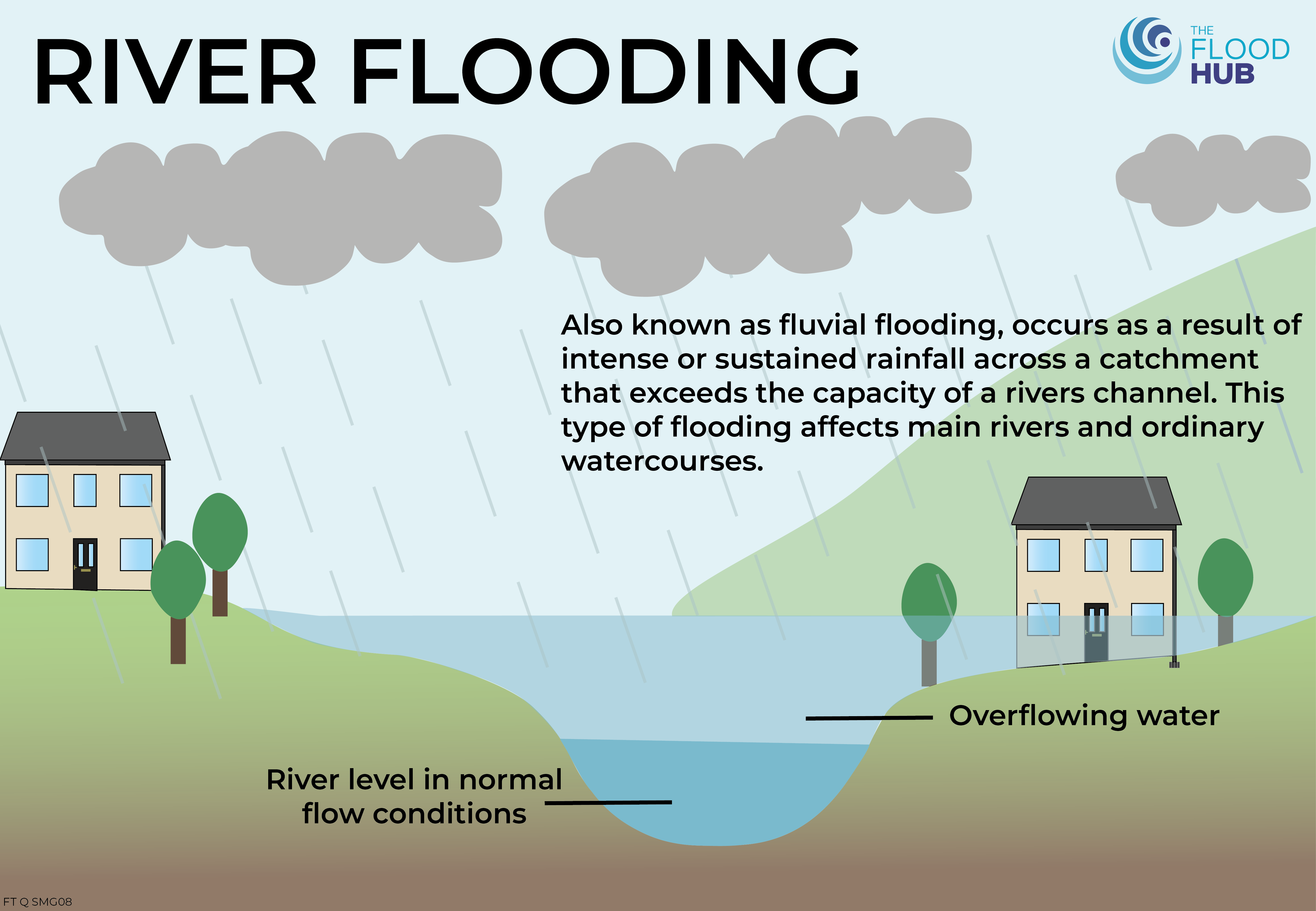
River flooding, also known as fluvial flooding, occurs as a result of intense or sustained rainfall across a catchment area and causes the capacity of the river to be exceeded. It can affect both main rivers and ordinary watercourses.
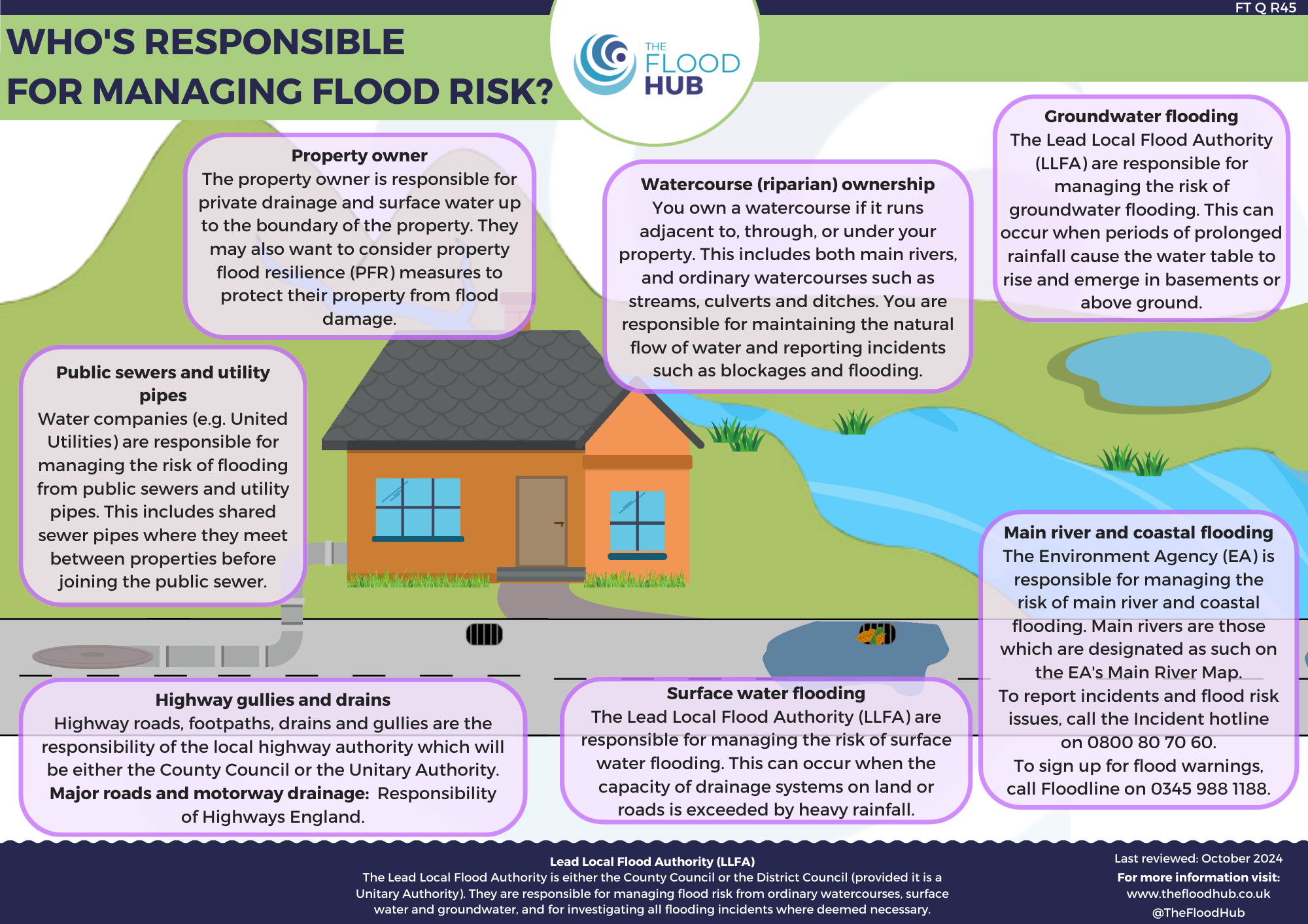
The Environment Agency is responsible for managing flood risk from main rivers, the sea and for the strategic overview of all flooding and coastal erosion management. They have a strategic overview of all sources of flooding and coastal erosion (as defined in the Flood and Water Management Act 2010). They lead on flood and coastal erosion risk management activities on main rivers and the coast. To report any blockages, flooding or pollution incidents, visit the GOV.UK website here or call their incident hotline on 0800 80 70 60.
Click here to find out what the Environment Agency do during an incident.
River Ribble during flooding in Ribchester, Lancashire
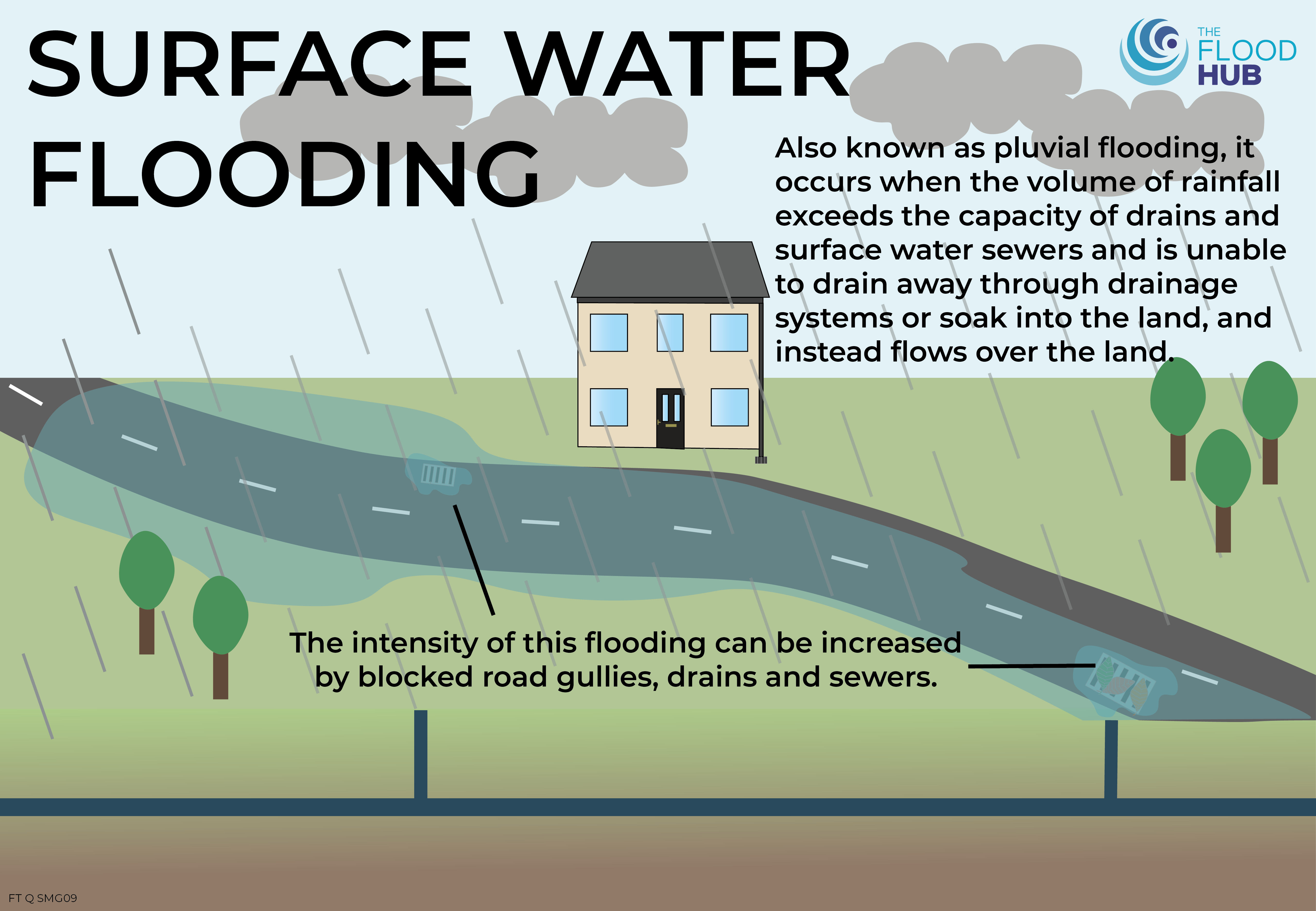
Surface Water Flooding
Pluvial flooding, also referred to as surface water flooding, happens when the ground can no longer absorb water or rainfall exceeds the drainage capacity of surface water sewers and drains, causing water to accumulate and flow overland instead of being absorbed. This type of flooding can be worsened by blocked road gullies, sewers, and drains, as well as saturated land and increased hard surfaces.
The Lead Local Flood Authority (LLFA) is responsible for managing the risk of flooding from surface water and producing local flood risk management strategies, as well as investigating and producing a Section 19 report for flooding incidents when deemed necessary. You should report this type of flooding to your LLFA which will either be the District Council, provided it is a Unitary Authority, or the County Council. Find your local council here.
FACT: The threat of surface water flooding has increased by 43% to 4.6 million (2024) since the Environment Agency’s last assessment (2018). In comparison, there is 2.7 million at risk from rivers and the sea. – Environment Agency
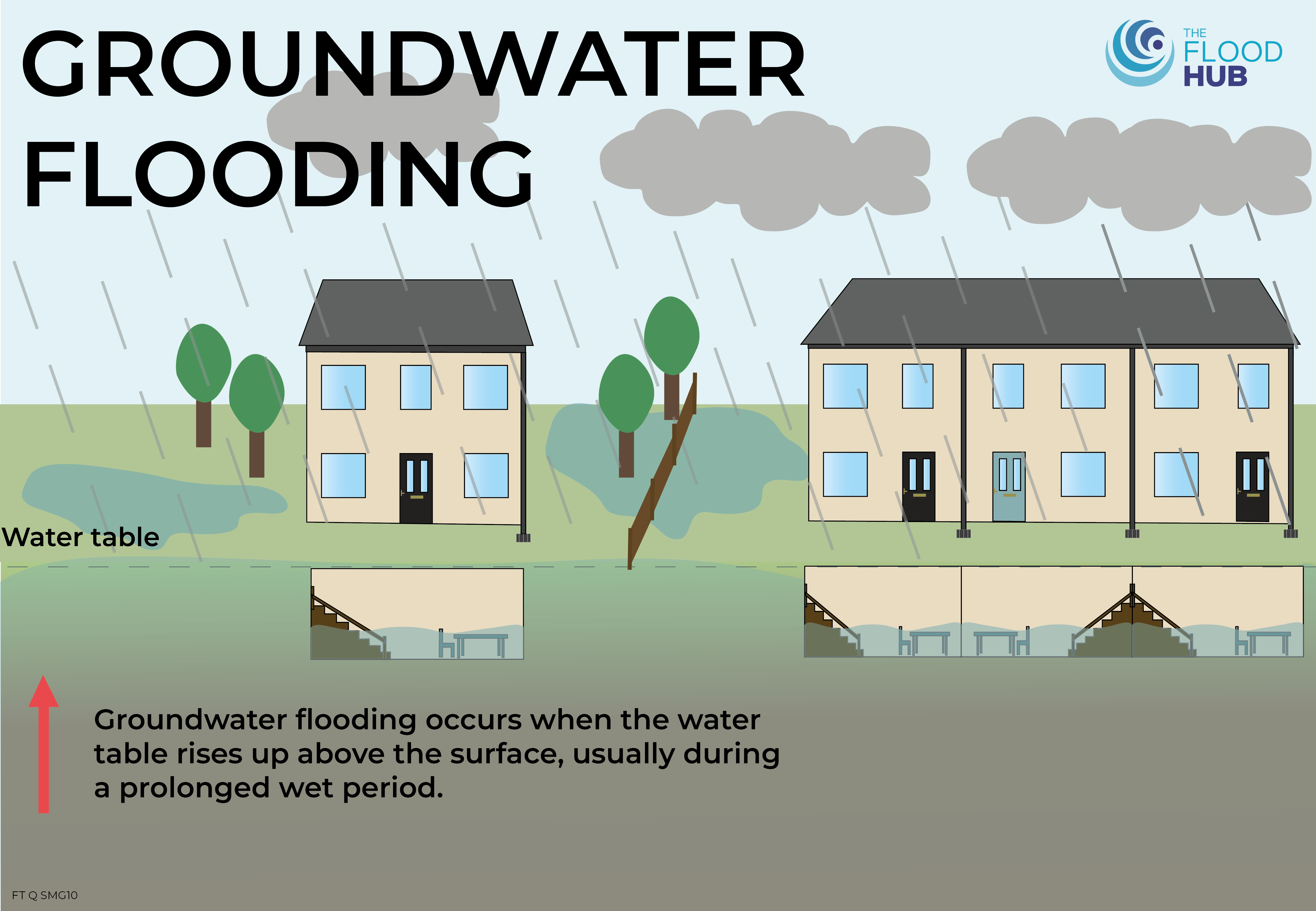
Groundwater Flooding
Groundwater flooding occurs when the water table rises above the surface, usually during a prolonged wet period. Low lying areas, areas near aquifers, and properties with cellars or basements are more likely to experience groundwater flooding. You can find out whether there are any groundwater flooding alerts or warnings here.
The Lead Local Flood Authority (LLFA) is responsible for managing the risk of flooding from groundwater and producing local flood risk management strategies, as well as investigating and producing a Section 19 report for flooding incidents when deemed necessary. You should report this type of flooding to your LLFA which will either be the District Council, provided it is a Unitary Authority, or the County Council. Find your local council here.
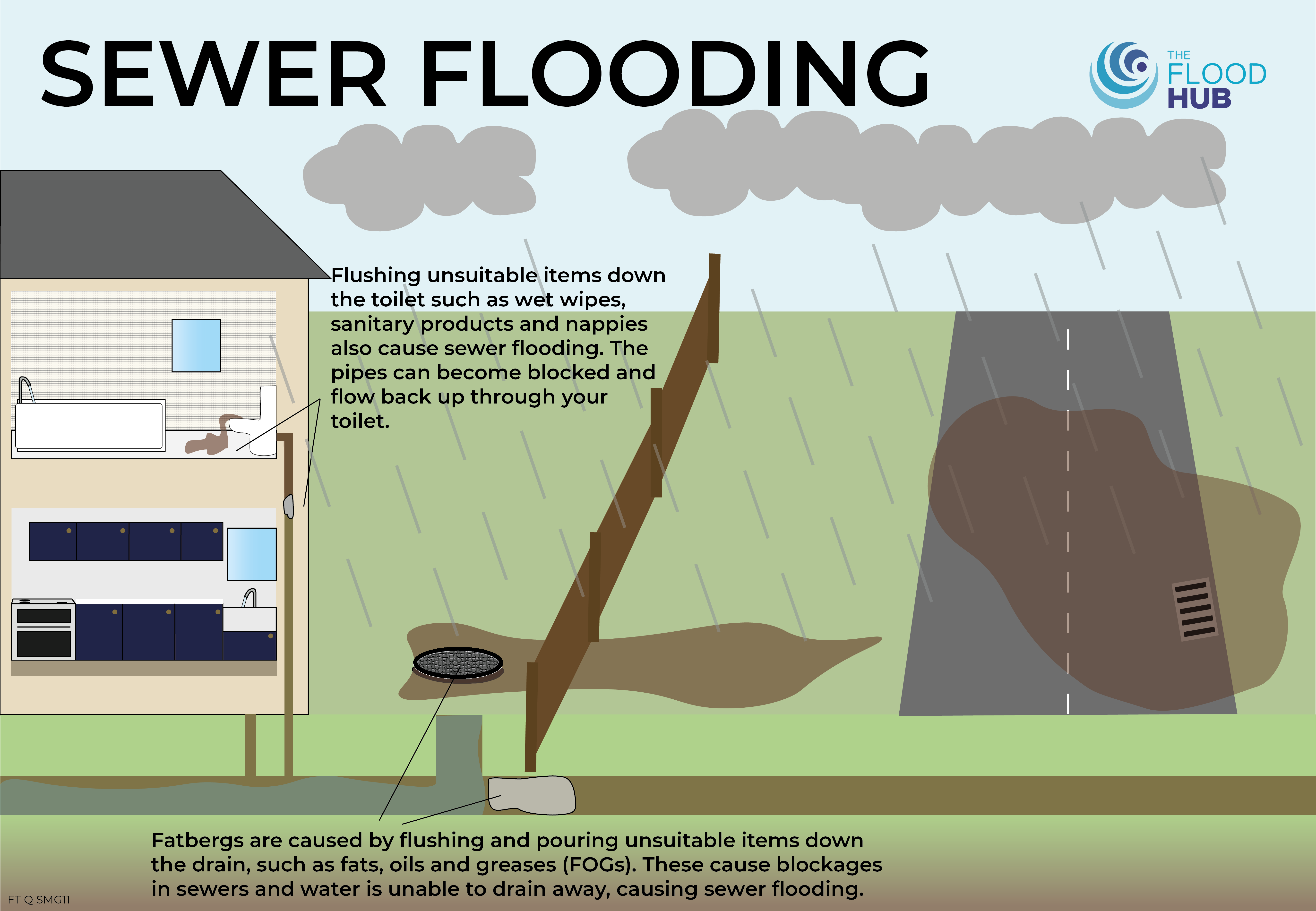
Sewer Flooding
Sewer flooding incidents usually happen as a result of blockages caused by the misuse of the sewerage system, for example, by flushing unsuitable items down the toilet. Heavy rainfall can also contribute to overloading the sewerage system, especially when there are blockages. It can be dangerous as contaminated sewage may end up in properties or rivers.
It is important that only the 3 P’s are flushed down the toilet (paper, pee and poo). Any other unsuitable items or fat, oil and grease (FOG) can lead to blockages and flooding. Check out our resource on ‘Sewers, Blockages and Flooding,’ here for more information.
Water and sewerage companies are responsible for managing the risk of flooding from public sewers and utility pipes. In the North West, this is United Utilities. To report sewer flooding call 03456 723 723, to report a leak or a burst water main call 0800 33 00 33, for blocked drains visit their website here, or visit this webpage for more information.
FACT: More than 3,000 homes are flooded in the UK every year because of fat, oil and grease (FOG) blockages and fatbergs – Southern Water.
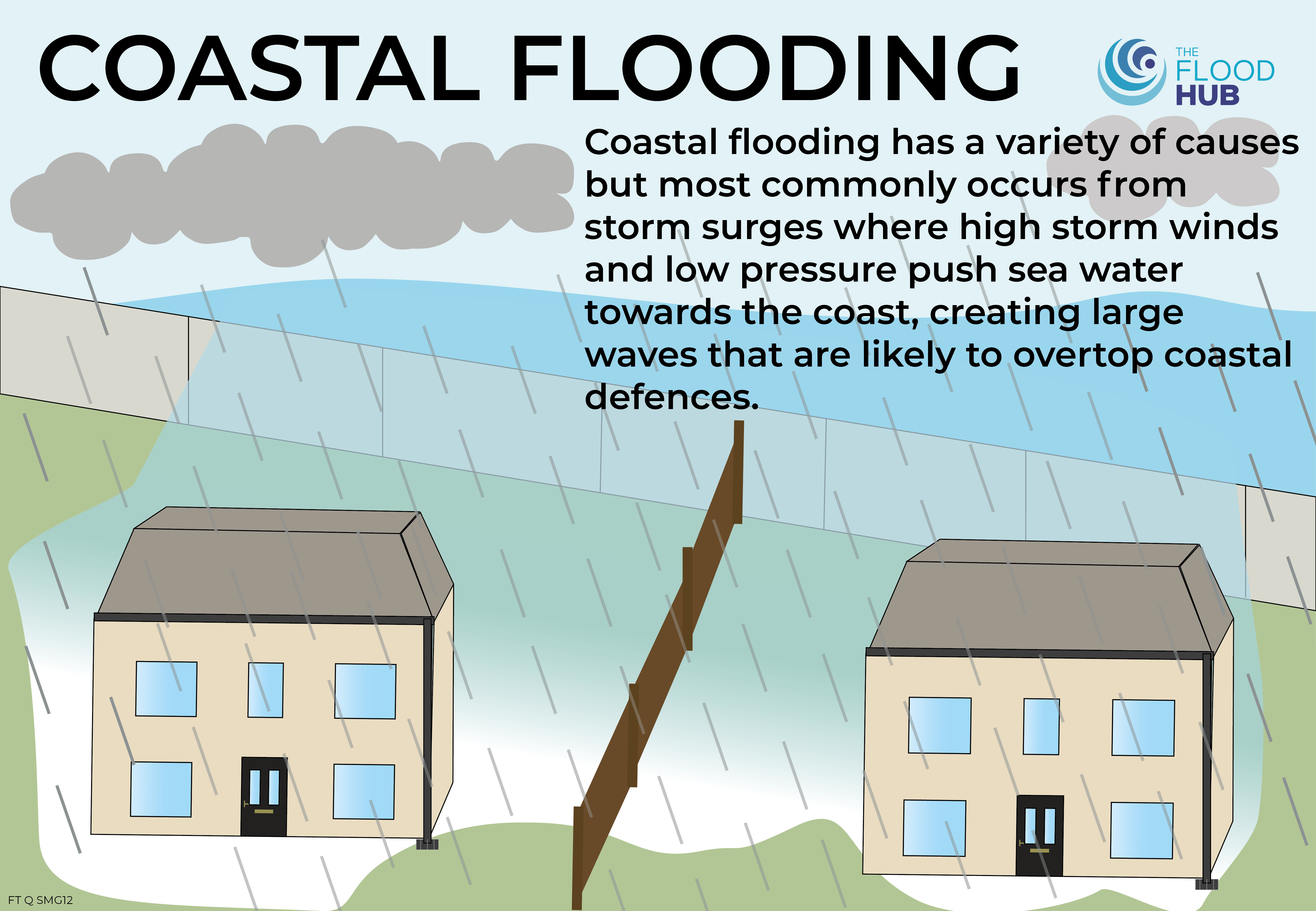
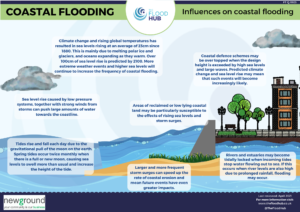
Coastal Flooding
Coastal flooding has a variety of causes but most commonly occurs from storm surges, where high storm winds and low pressure push sea water towards the coast, creating large waves that are likely to overtop coastal defences. Coastal erosion causes the coastline to retreat inland, increasing the risk of coastal flooding and the potential loss of land.
Climate change is causing rising sea levels of around 4mm per year, which may contribute to flooding, as not only does it make low lying land more vulnerable but it gives storm surges a higher starting point. Flooding may be more likely on developed land that has been reclaimed from the sea via coastal management. Even a small rise in sea levels may be enough to cause flooding in these areas.
The Environment Agency is responsible for managing flood risk from the sea, main rivers and for the strategic overview of all flooding and coastal erosion management. To report any blockages, flooding or pollution incidents, visit the GOV.UK website here or call their incident hotline on 0800 80 70 60.
Download our ‘Influences on coastal flooding’ resource here.
Fact: The Environment Agency’s updated assessment shows how coastal erosion risk is changing across our shorelines, with 3,500 properties expected to be in areas at risk of coastal erosion in the period up to 2055, increasing to about 10,100 properties by the end of the century.
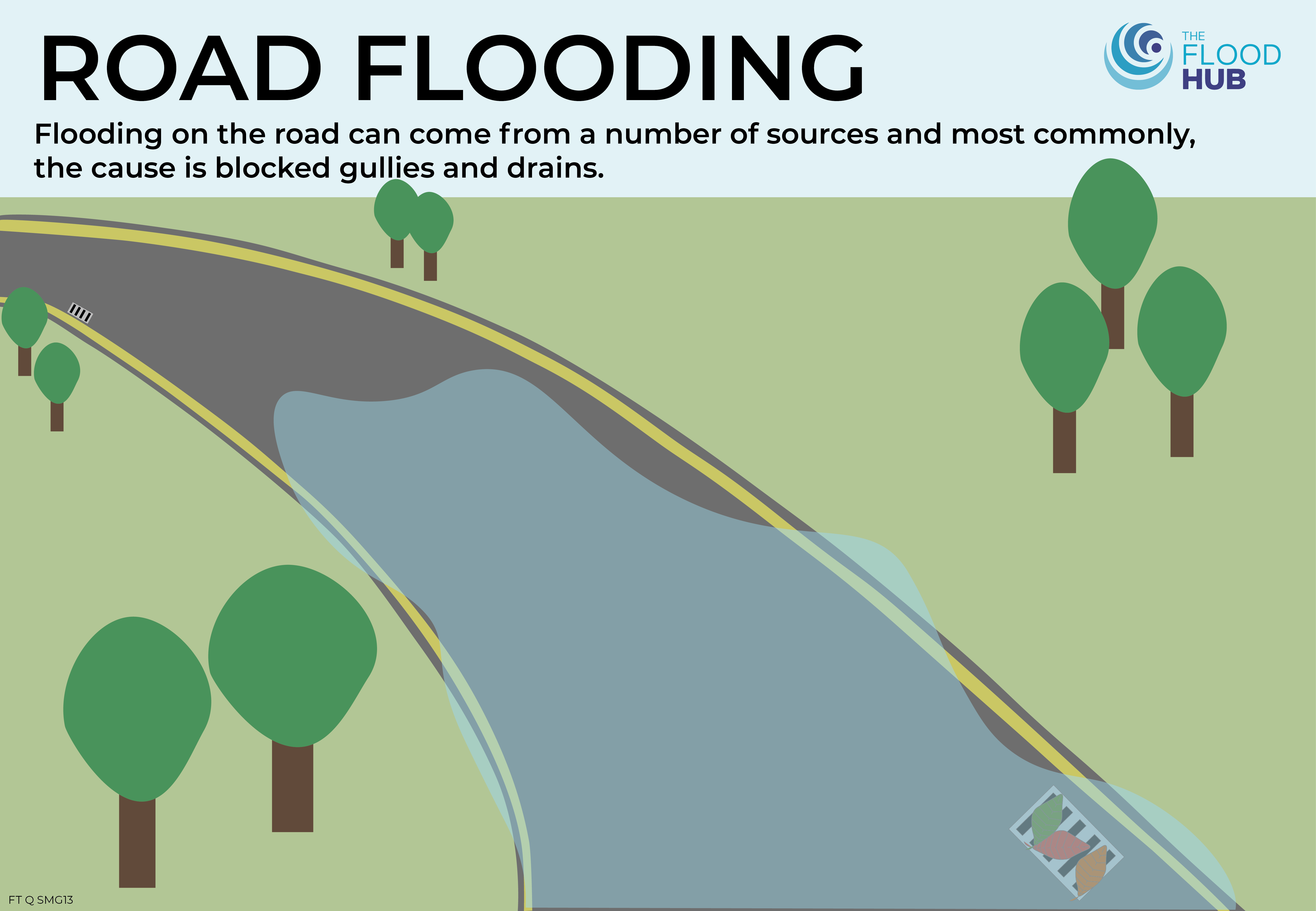
Road Flooding
Flooding on the road can come from a number of sources and most commonly from blocked gullies and drains and the exceeded capacity of the drainage system when there is heavy rainfall.
The highway authority are responsible for ensuring that there is no increased flood risk from any roads and road projects. For gullies and drains on main roads and smaller roads, the highway authority is usually the County Council or Unitary Authority. To report flooding to them, find your local council here. National Highways is the responsible highway authority for flooding on major roads and motorways.
Road flooding in Ribchester, March 2019
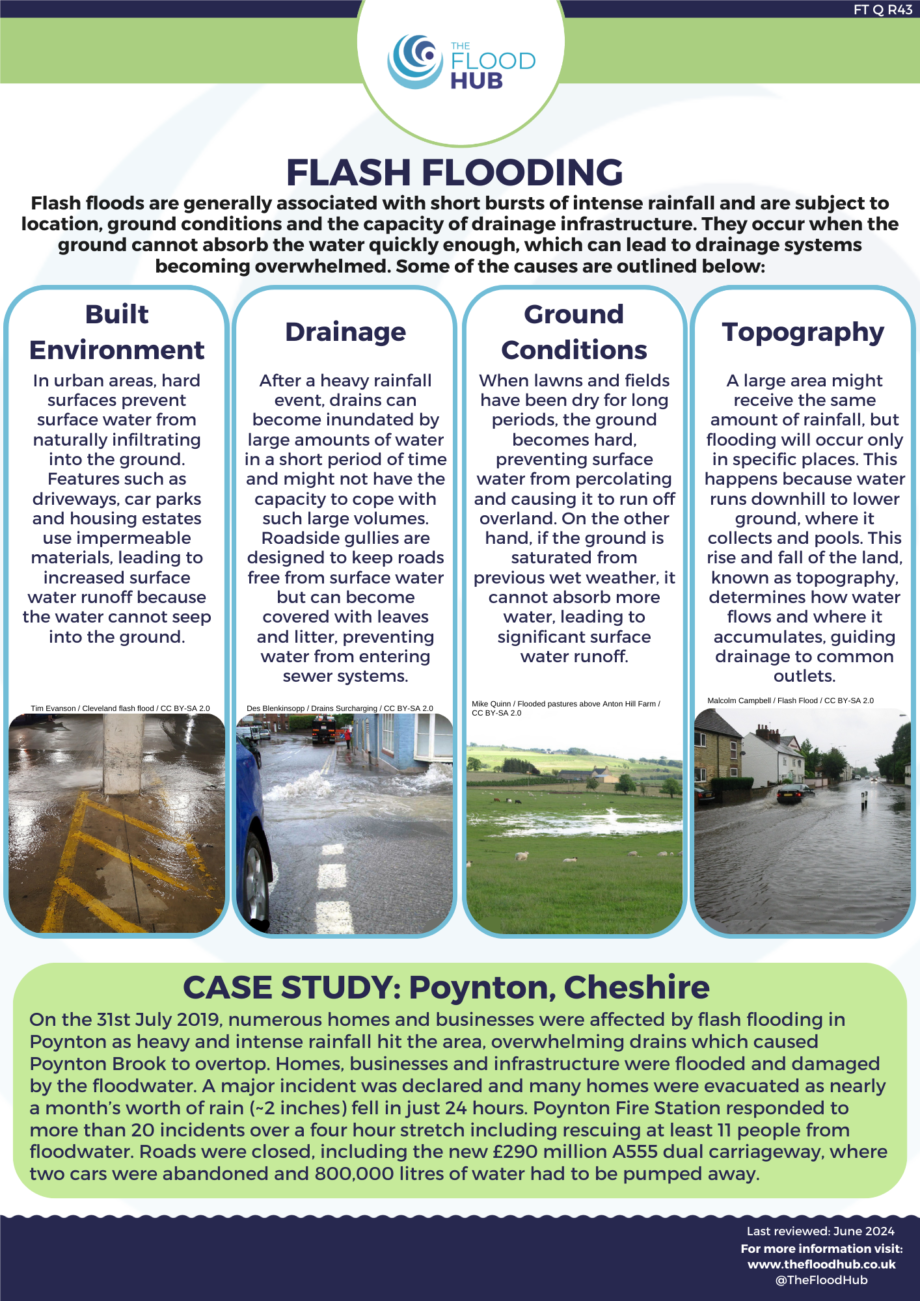
Flash Flooding
Flash flooding often happens without warning due to intense and heavy rainfall. Places that have gone through a long period of dry weather, as well as urban areas with a lot of hard surfaces, are at higher risk of flash flooding as the land can’t absorb the water. Locations situated near steep valleys are particularly vulnerable to this type of flooding.
The Environment Agency have put together some further information on flash flooding, click here to find out more.
The source of the flash flood will often determine who is responsible for managing the flood risk.
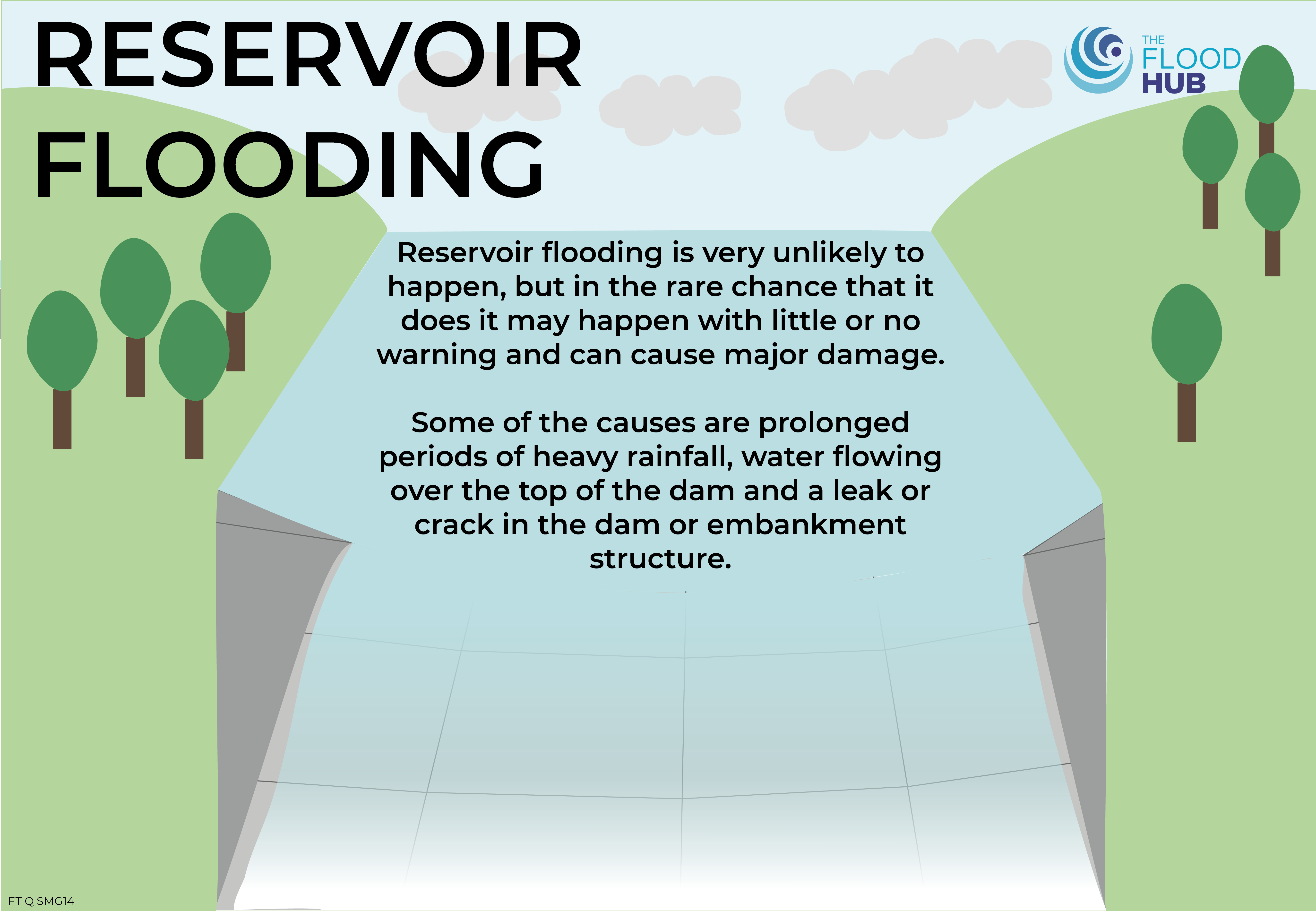
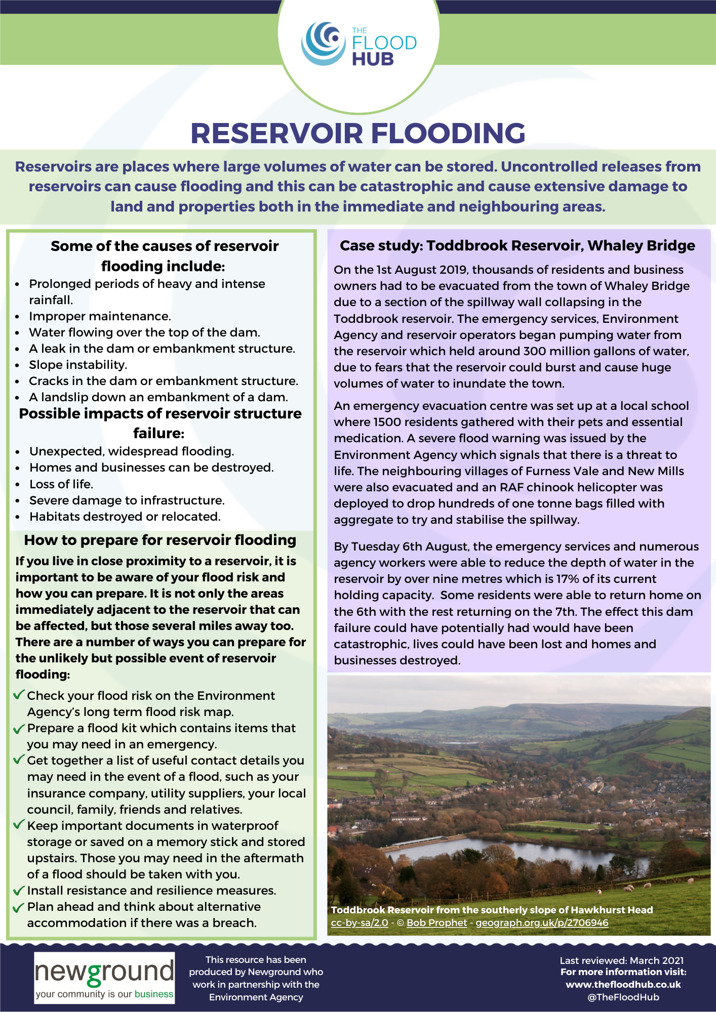
Reservoir flooding is very unlikely to happen, but in the rare chance that it does, it may happen with little or no warning and can cause major damage. Some of the causes of reservoir flooding include improper maintenance, a leak or crack in the dam or embankment structure, a landslip down the embankment of a dam and slope instability. Most large reservoirs are operated by water companies (United Utilities in the North West) or the Environment Agency, and are regularly monitored and inspected to ensure they are safe. Reservoir maps were created to help authorities and emergency services plan for the risk of reservoir flooding, by showing how far flood water would spread in a worst case scenario.
If you own or operate a reservoir, there are certain requirements which must be met and different sized reservoirs have different requirements. ‘Large raised reservoirs’ are those which hold at least 25,000 cubic metres of water above ground level and they must be registered with the Environment Agency.
Download our Reservoir Flooding one page summary here and our ‘Introduction to Reservoir Flooding’ booklet here.
Canal Flooding
Canal flooding occurs when the water levels are too high and over top, which can happen when locks are operated incorrectly or vandalised. Flooding from canals is rare, but even with the best controls in place there can sometimes be too much water to manage.
Incidents can be reported to the Canal and River Trust, during office hours, by calling 0303 040 4040. If the canal towpath is flooded or there is a failure of the canal bank, there is a 24 hr emergency contact number 0800 479 9947. If there is an emergency call 999.
Who's Responsible for Managing Flood Risk
Introduction
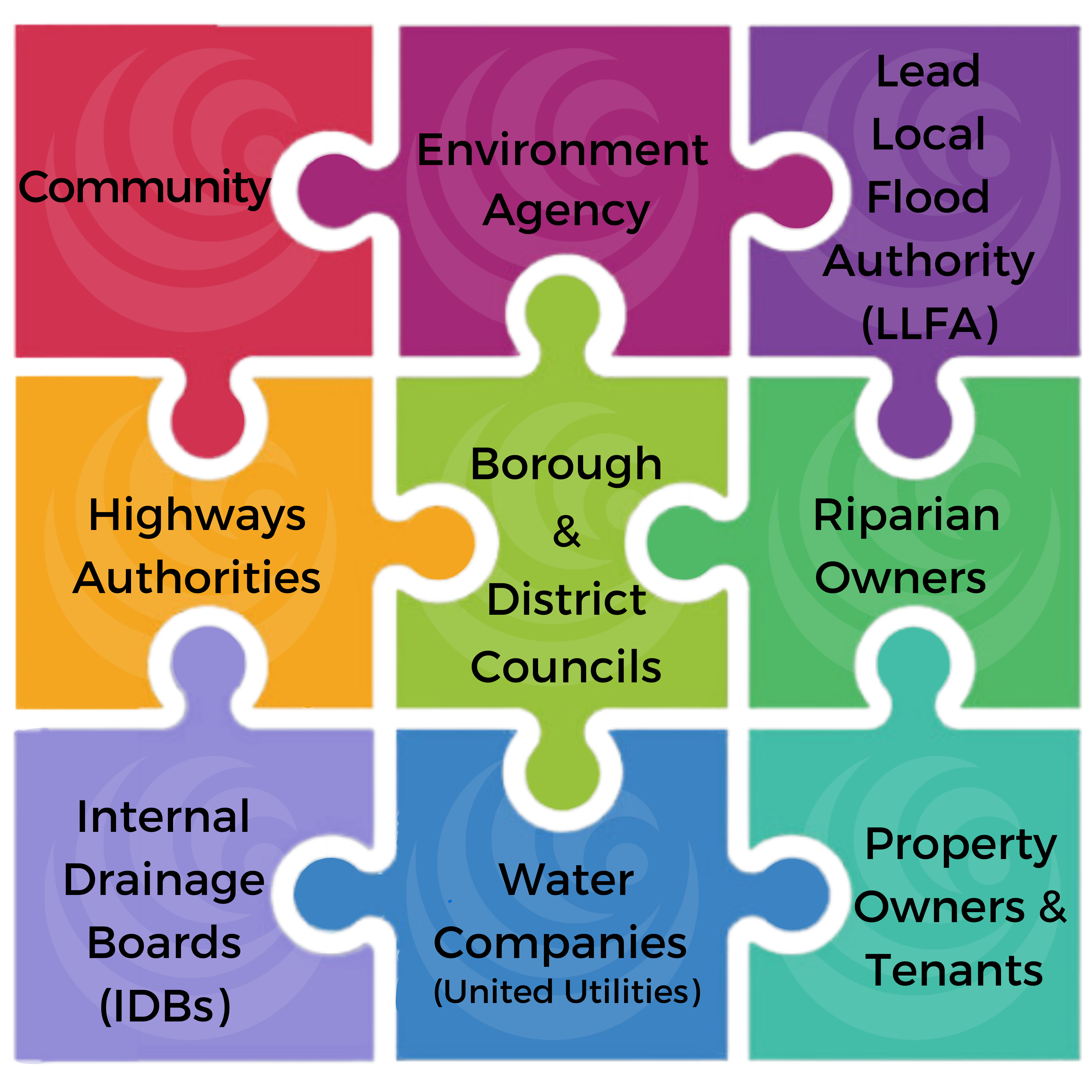
There are a number of ways that an area can flood; various Risk Management Authorities (RMAs) and individuals have a stake in managing flood risk from different sources.
The catchment-based approach to managing the risk of flooding looks at better managing the flow of water throughout the whole catchment by using a range of different interventions by various stakeholders. A whole catchment approach to flood management looks at flooding like a puzzle made up of lots of interconnected pieces, and it attempts to solve the puzzle by implementing multiple interventions which fit those pieces together.
For more information on how flood risk is managed and who is involved, please visit our page by clicking here.
For an overview on the types of flooding download the resource here, or for a summary of who’s responsible for managing flood risk from different sources, download the resource here.
Visit our ‘Report’ section here tor a straightforward guide on who to report the different types of flooding to.
Householders and Other Property Owners
Responsible for managing flood risk from:
Internal flooding e.g. caused by a burst water pipe.
Any damage caused by storm events.
All private drainage inside and up to the boundary of the property.
Householders and other property owners may wish to consider Property Flood Resilience (PFR) to better manage their properties’ flood risk.
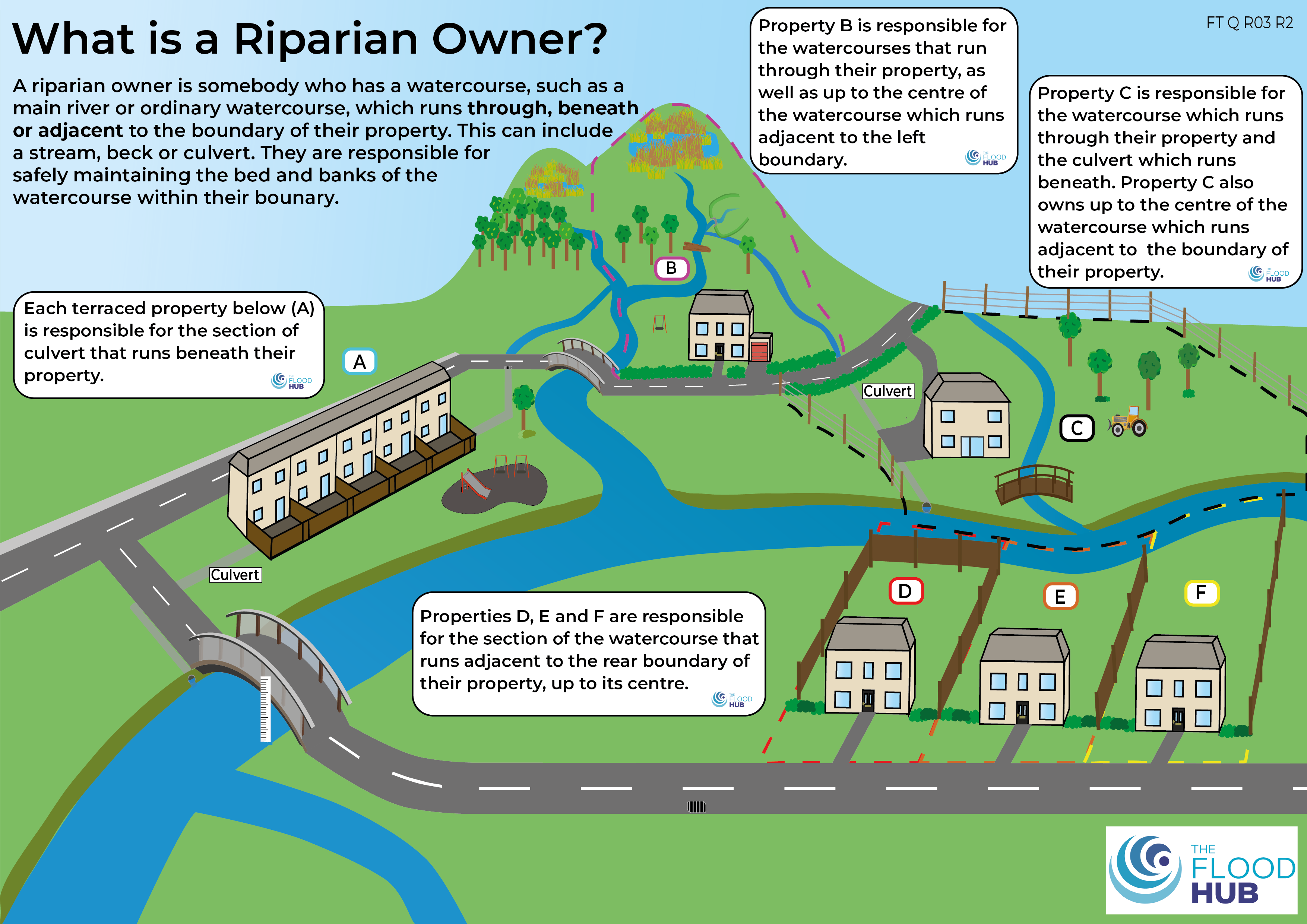
Riparian Owners
Also known as watercourse owners, riparian owners are responsible for maintaining watercourses that run through, beneath, or adjacent to their land, including culverts, ditches, brooks, dykes and streams. Flooding from these watercourses due to a lack of maintenance could lead to legal action. Find out more about watercourse ownership and responsibilities on our Landowner page here, or go directly to GOV.UK to the Environment Agency’s ‘Owning a watercourse’ guidance here.
See if you’re a riparian owner by downloading our ‘Are you a riparian owner?’ flowchart here.
Download our ‘What is Riparian Ownership?’ resource here.
Flood Warnings and Triggers
Flood Warnings
Flood alerts and warnings are a great way to keep up to date with the flood risk and the river and sea conditions in your area, allowing you to be pre-warned of any risks towards your property.
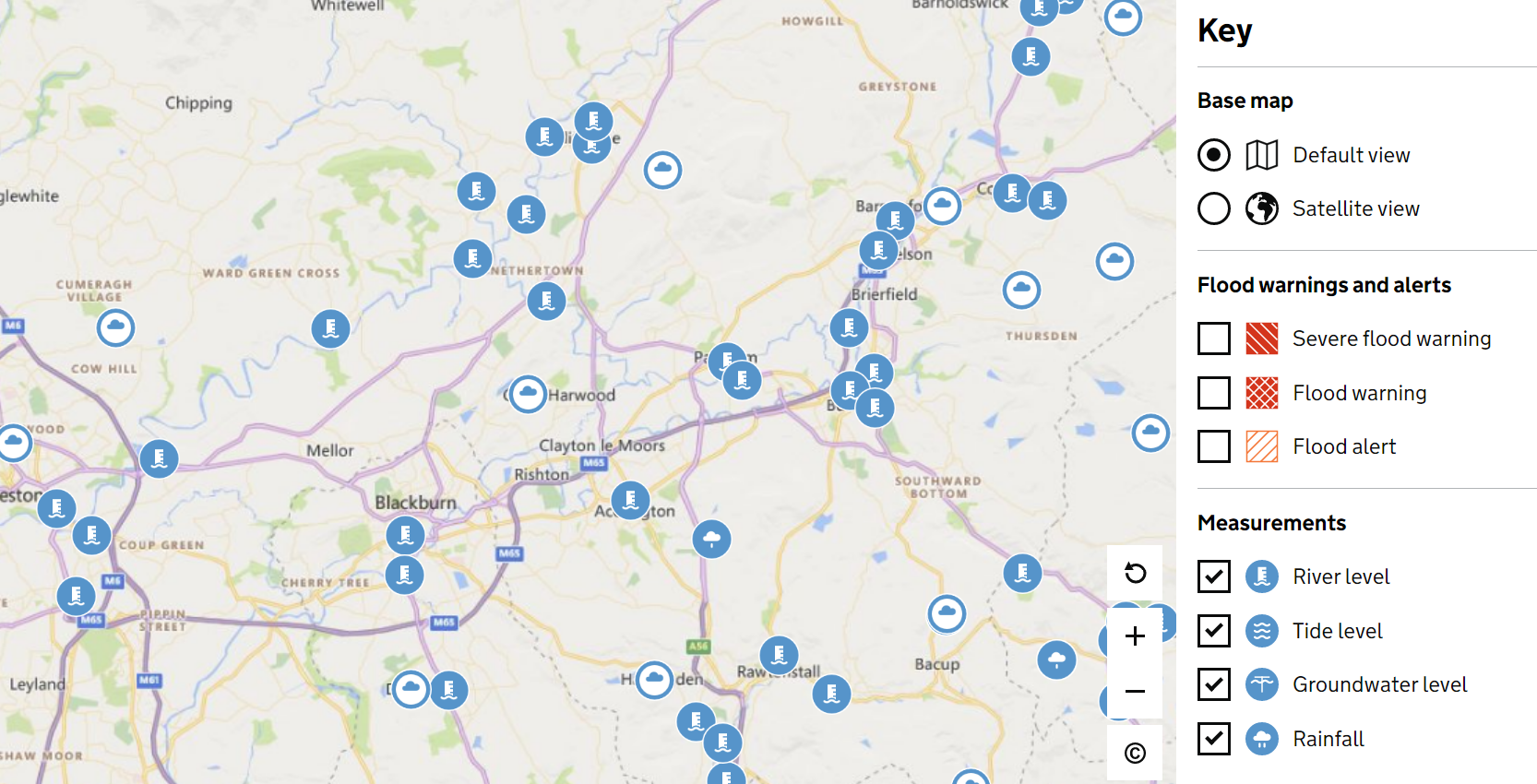
The Environment Agency Check for flooding service
The ‘Check for flooding’ service is provided by the Environment Agency and allows users to input their postcode and find out the:
current flood warnings or alerts
river, sea, groundwater and rainfall levels
flood risk in the next 5 days
Image of Live Flood Map which can be viewed via the Environment Agency’s ‘Check for Flooding’ service.
The page is regularly updated and provides information on the risk of flooding from rivers, the sea and groundwater only. There’s information on how to sign up for flood warnings and how to find out your risk of flooding from surface water.
The Environment Agency measures current river and sea levels across England via Environment Agency monitoring stations. For each river monitoring station there is a graph available that shows the threshold level which, if exceeded, means flooding may be possible at that location. These recorded river levels can act as a trigger for the Environment Agency Flood Alert and Warning service.
The Environment Agency offers a free Flood Warning Service that enables people in flood warning areas to receive flood alerts and warnings by telephone, text and email, even if you are not at home when they are sent. You can easily sign up to receive these warnings on the website or via telephone on 0345 988 1188 to give yourself more time to prepare for a flood. Understanding what each warning stage means is important in avoiding unnecessary panic and stress. These warnings cover the risk of flooding from main rivers and the sea, but do not cover flooding from surface water or sewer flooding.
Flood Alert: Flooding is possible. Stay vigilant and make early preparations for a potential flood.
Flood Warning:Flooding is expected. Immediate action is required to protect yourself and your property.
Severe Flood Warning:Severe flooding is expected. Significant risk to life and property. Prepare to evacuate and cooperate with emergency services.
It is important to note that not all areas at risk of flooding are covered by the Environment Agency’s Flood Warning Service.
For more information on the actions to take at the different flood alert and warning stages, see our flooding planning section here.
This flood warning resource outlines what steps to take should a flood warning be issued. Click here to download.
Video Player
Media error: Format(s) not supported or source(s) not found
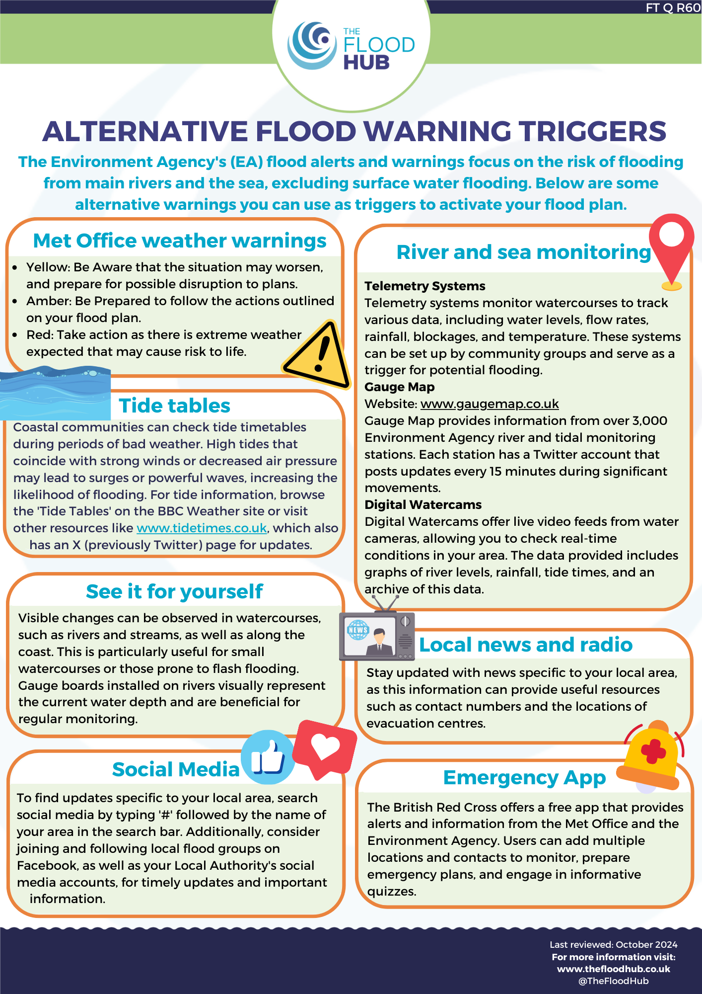
There are a range of ways to receive flood and weather warnings and keep up to date with your local flood risk, allowing you to act upon triggers to put your flood plan into place. As well as the Environment Agency’s flood warning service, here are some alternatives:
Met Office Weather Warnings
The Met Office provides a Weather Warning Service on their website that uses a colour coded system of warnings. The three warning levels are:
Yellow: Possible severe weather, plan ahead for potential disruption.
Amber: Increased risk of bad weather and danger to life, prepare to take action. *It is usually recommended to trigger your flood plan at this level*
Red: Extreme weather expected and risk to life; follow advice of emergency services.
You can download the MET Office app on your smartphone to receive notifications when a severe weather warning is issued. The app also provides access to a rainfall radar tool which can help predict heavy rainfall over the coming 5 days.
Digital watercams
Water cameras are present on all types of watercourses across the UK. There are many sites available online where you can search a map or enter a postcode to find a watercam near you. The cameras show live or regularly updated conditions of rivers and watercourses, with some also providing graphs of river levels, rainfall and tide times, as well as archive photos of past conditions.
Emergency App
The Emergency App from the British Red Cross provides information and alerts for flooding and other emergencies. You can tailor the app to notify you about weather conditions in certain places, and can add chosen contacts for those areas. There are other similar apps available that you may find useful.
News and radio
By keeping up to date with your local news and radio you will be more informed and prepared to act when severe weather occurs. You can do this by tuning in to local radio stations whilst driving and downloading news apps to receive newsflashes.
Gauge boards
Gauge boards show the current height of water on various rivers and watercourses. They are physical boards installed at specific locations on a watercourse and can usually be viewed from a river bank or crossing. In the absence of a gauge board you can familiarise yourself with the normal level of the watercourse so you can detect abnormally high water levels in times of flooding. These methods are useful when flooding is common in an area, as you can use certain water levels as a trigger for your flood plan.
Gauge boards by the River Ribble in Ribchester, Lancashire
Private flood level alarm systems
These alarm systems are designed to give you a more localised trigger and provide ample time to implement temporary defence measures. They are most suitable for properties with a watercourse nearby or on private land. They usually include an indoor alarm unit, and a water sensor installed at a location where rising floodwater will be detected early, well before flooding commences.
Click here to download our ‘Alternative Flood Warnings’ resource.
If Flooding is Expected
Quick actions if flooding is expected
Here are some quick steps you can take to try and minimise the damage from flooding and keep yourself safe…
If you have a flood kit or flood plan get them out and ready to use
Put property flood resilience measures such as flood barriers in place
Move items upstairs or to safety if you can
Move your car to safety if you can
Stay up to date with local weather and travel on the TV, radio or social media
If you need to evacuate…
Turn off your gas, electricity and water supplies if it is safe to do so
Follow advice from the emergency services
Move your family and pets to safety
Call 999 if you are in danger
For more detailed information about planning and preparing for flooding, visit our Household pagehere.
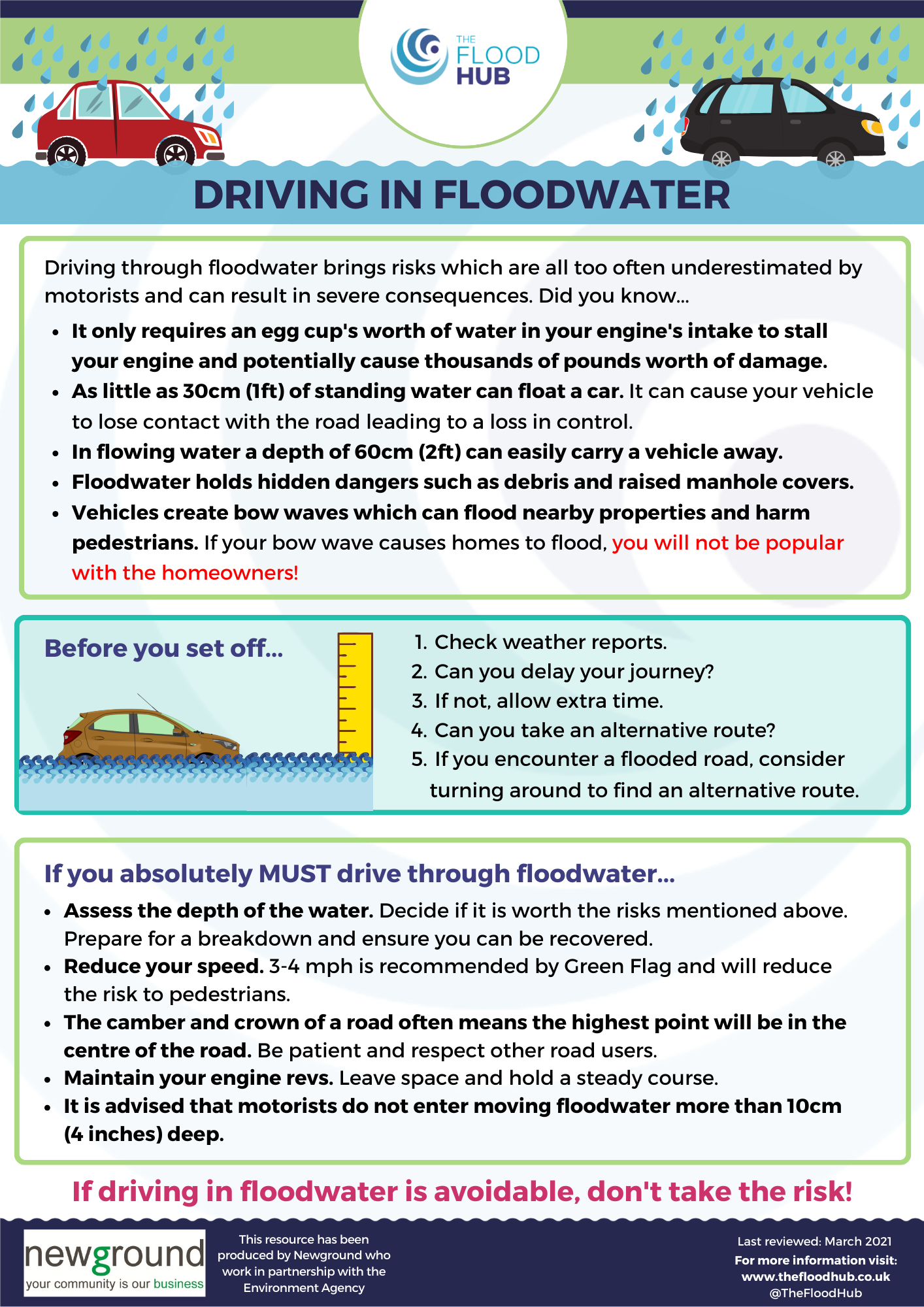
Driving through Floodwater
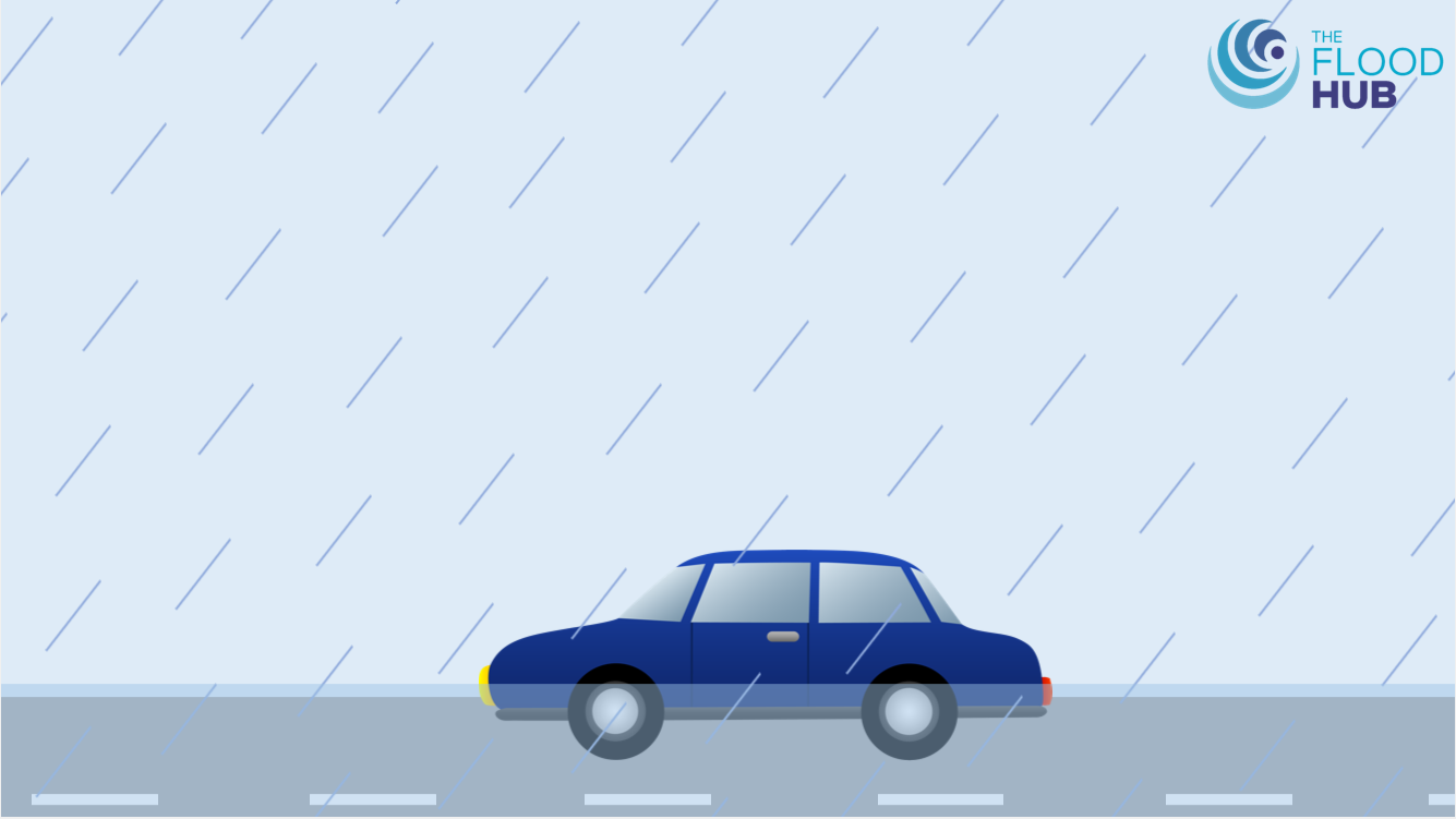
You should not attempt to drive if the roads are flooded. To avoid water damage, you should move your vehicle to higher ground if flooding is expected. If you feel that driving is unavoidable in severe weather conditions or if you are perhaps caught in heavy downpours and flash flooding, consider these points:
Check the news – Regional news bulletins will provide information about road closures and localised flooding. The Met Office will have live weather forecasts for the area and the Environment Agency’s flood alerts and warnings may be issued.
Delay the journey – Is it possible to delay the journey or take an alternative route to avoid the flooded area?
Water depth – It is advised that motorists do not enter flood water that is moving or more than 10cm (4 inches) deep.
Speed – 3-4 mph is recommended by Green Flag! Have some consideration for other road users and pedestrians. Drive at low speed to avoid or reduce bow waves, as these can flood other vehicles and cause greater amounts of water to enter properties, adding to flood damage.
Bow waves – Driving through flood water can create bow waves which can result in floodwater crossing doorway thresholds and entering air bricks. If your actions when driving through floodwater cause a property to flood, the homeowner will not thank you for it!
For more information, click here to read our blog or download our ‘Driving in Floodwater’ resource, which can be found by clicking here. Check out our animation below.
Video Player
Media error: Format(s) not supported or source(s) not found
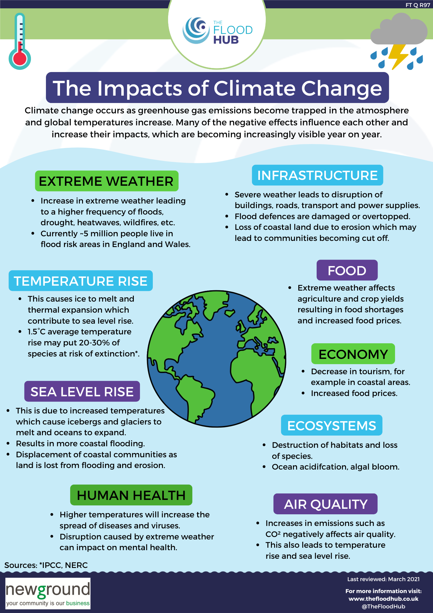
Climate change is increasing the risk of flooding to both coastal and inland communities. Over the last 10 years, record breaking rainfall and floods have become a new normal.
The world is facing a climate emergency as human activity has caused an increased rate in the release of greenhouse gases into the Earth’s atmosphere, largely resulting from the Industrial Revolution and the increased burning of fossil fuels. Increased emissions trap the sun’s energy in the atmosphere and cause a rise in global temperatures which results in the following effects becoming increasingly visible year on year:
Rising sea levels
More extreme weather including heat waves, storms and flooding.
Negative impacts on human health, air quality, food, the economy and ecosystems.
Disruption to infrastructure.
To check how climate change might increase the chance of flooding in your area, click here to view the ‘Long Term Flood Risk Map’.
Download our ‘Impacts of Climate Change’ resource here.
We also have our own KS2 Climate Change Education Package which can be found here.
To find out more about the climate emergency, visit the United National Environment Programme (UNEP) website here.
Rochdale Borough Council’s ‘Climate Conversations – Think global, act local – part one’ video.
With climate change, the total number of properties in areas at risk from rivers and the sea or surface water could increase to around 8 million by the middle of the century – or around one in four properties.