
This is a developing story and will be updated. For the most up-to-date information about the fire you can check:
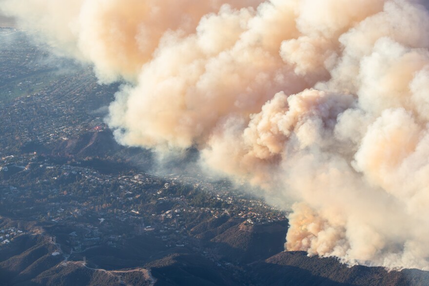
Containment of the massive Palisades Fire increased to 63% Tuesday as red flag conditions are expected to return.
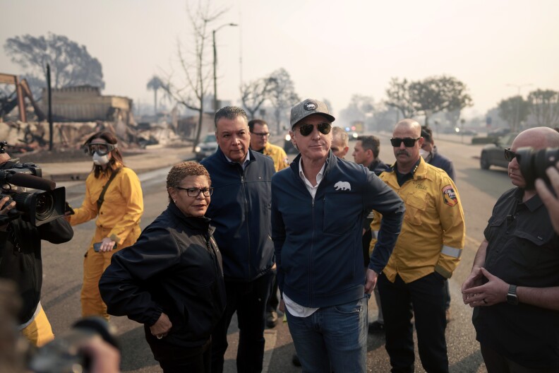
The death toll in the fire that devastated whole neighborhoods rose Tuesday to 11 people. Authorities continue to search the ruins with cadaver dogs.
As of Wednesday morning, sheriff's officials said in areas they patrol they are still investigating six missing people reports in the Palisades Fire.
LAPD officials said they've investigated 38 reports of missing people in the Palisades Fire, and 30 have been found safe. Authorities said they believe that of the eight still missing, three are "most likely" among the dead who have not yet been positively identified and five remain missing.
Roughly 5,000 structures are estimated to have been destroyed, about 700 damaged.
Repopulation begins in some areas
The Sheriff's Department said Thursday afternoon that some evacuation zones will be reopened to residents effective noon on Thursday, Jan. 16.
The following zones will be reopened to residents:
- Zone TOP-U001: North of Topanga Canyon Boulevard and South of Mulholland Dive
- Zone TOP-U002: North of Old Topanga Canyon Road and South of Summit to Summit Motorway
- Zone DRY-U026-A: North of Mulholland Highway and South of Stokes Canyon Road
- Zone RRC-U027-A: North of Red Rock Road and South of Calabasas Peak Motorway
"Resident access will be through the intersections of Mulholland Highway/Old Topanga Canyon Road, Civic Center Way/Malibu Canyon Road, and Mulholland Drive/Topanga Canyon Road," according to the LASD update.
On Friday, some areas under evacuation orders were open for residents.
Orders reduced to warnings:
- RMB-U030D and RMB-U030E in the Malibu Creek area along Malibu Canyon Road
- Areas bordering the 405 Freeway and Stone Canyon Reservoir: LOS-Q1118, LOS-Q0765, LOS-Q0778A, LOS-Q0798, LOS-Q0781-A, LOS-Q0782-A, LOS-Q0782-B
Areas reopened to only residents:
- LOS-Q0767-B along Mandeville Canyon
- LOS-Q0767-C which includes much of Sunset Blvd and Riviera Country Club
- LOS-Q0782-C which includes parts of Kenter Canyon
- Much of Topanga Canyon including zones TOP-U003, TOP-U004, TOP-U005, TOP-U006, TOP-U007B, TOP-U008A, TOP-U009B
- DRY-U026C along Stunt Road
- RRC-U027B
- MNT-U028B
- SDP-U029B
The sheriff's department said evacuees should have proof of residency when they try to re-enter and that only residents are currently allowed back in.
Here's what to know about returning home after a fire evacuation.

The basics
- Acreage: 23,713 acres
- Containment: 63%
- Structures damaged or destroyed: 5,000 estimated destroyed, about 700 damaged
- Structures threatened: 12,250
- Residents under evacuation warnings and orders: 20,000
- Cause: Unclear
- Injuries: Multiple significant injuries to both residents and firefighters
- Deaths: 11 civilians
What's next
We have some respite from fire weather conditions through Saturday.
This week, L.A. Councilmember Traci Park, who represents the area, told LAist 89.3's AirTalk program that officials will be asking "some very hard questions about what happens and what we are going to do to ensure that something like this never happens again."
"Because frankly," she added, "much of what occurred — even though this was an unusual weather event — what's predictable? The Pacific Palisades is in the very high fire severity zone."


Where things stand
Firefighters have been injured, as have a significant number of residents who didn't evacuate in time, according to authorities. That's in addition to at least 11 reported deaths.
After days of 0% containment, that number moved to 6% a week ago. Last Friday, it was at 22%.
We should note that the estimate of more than 5,000 structures damaged or destroyed is still preliminary and could change. The case is the same for the number of deaths — it takes time to identify remains and L.A. County Fire Department noted there have been more than a dozen missing person reports in their jurisdictions in both the Eaton and Palisades fires.
CalFire also cautioned against believing inaccurate social media posts. One claimed that people can come to California to join clean up efforts, but authorities warned this is false.
What we know about the deaths
L.A. County's medical examiner has confirmed 11 deaths in the Palisades Fire. One victim, Charles Mortimer, 84, died at a hospital.
Damage so far
Officials are mapping where homes and businesses have been lost.
Videos: What the damage looks like
Curfews in place
Curfews are now in place for fire areas from 6 p.m. to 6 a.m. until further notice.
The L.A. County Sheriff's department said they have made at least 22 arrests for people violating those curfews in the Palisades and Eaton fire areas, mostly on suspicion of looting.
Authorities warn that anyone who violates the curfew is subject to arrest for a misdemeanor offense, and may face jail time, fines, or both, officials said.
" All these individuals were not supposed to be there, meaning they had no business being there ," said LA County Sheriff Robert Luna at a press conference Saturday morning. "You go out there and you violate this curfew, you are going to spend time in jail. You're not going to get cited and released."
Emergency declarations
L.A. Mayor Karen Bass declared a state of emergency Tuesday night. Newsom also proclaimed a state of emergency in Los Angeles and Ventura counties on Tuesday after meeting with fire officials in Pacific Palisades.
President Joe Biden approved a Presidential Major Emergency Declaration on Wednesday to support the response to the wildfires. He said on social media that he’s directed the Department of Defense to provide additional personnel, and ten Navy helicopters with water buckets are on the way.
How we got here
Driven by strong winds, it turned into a nightmare scenario that many hoped would never come to pass: an unstoppable fire tearing through densely packed coastal neighborhoods positioned between steep mountains and the Pacific Ocean, with few ways in and out.
While the full extent of the damage is not yet known, it's clear that the storied coastal stretch of Pacific Coast Highway between Santa Monica and Malibu will never be the same. Long standing businesses, including the Reel Inn, a seafood restaurant located across the street from Topanga State Beach, have been destroyed.
The fire was reported around 10:20 a.m. on Tuesday and immediately began heading toward the community of Pacific Palisades, driven by 70 mph wind gusts. The fire grew from 10 acres to 200 acres in just minutes.
During the early hours of evacuations, some residents fleeing the fire were told by officers to abandon their cars and walk to safety.
Many were seen holding bags and pets as they made their way towards the ocean. Abandoned vehicles were then bulldozed to make room for emergency vehicles.
Total destruction in Malibu. These were beachfront homes on Pacific Coast Highway. #palisadesfire pic.twitter.com/DhQnJMmoUW
— Liz Kreutz (@LizKreutzNews) January 8, 2025

Evacuation map and orders
Evacuation zones are changing fast, so check out the most up to date, interactive map here.
Authorities on Tuesday announced certain areas would open for repopulation:
LA County Sheriff's Eaton Fire Update for Tuesday, January 21st, 2025: Repopulation and Safety Guidelines
— LA County Sheriffs (@LASDHQ) January 21, 2025
LASD announced evacuation warnings have been lifted for the following evacuation zone communities impacted by the Eaton Fire, effective 12:00 P.M. on Tuesday, January 21st,… pic.twitter.com/ArKB0lIkfh
Officials are pleading with people to avoid the wildfire areas, especially if you don’t live there.
Evacuation centers
Van Nuys Sherman Oaks Rec Center, 14201 Huston St., Sherman Oaks
Lanark Recreation Center, 21816 Lanark St, Canoga Park
Westwood Recreation Center: 1350 S. Sepulveda Blvd. (accepts small animals)
Pasadena Convention Center: 300 E Green St, Pasadena, CA 91101
El Camino Real Charter High School: 5440 Valley Circle Blvd., Woodland Hills, CA 91367
Pierce College: 6201 Winnetka Ave. Woodland Hills, CA 91371 (accepts large animals)
Los Angeles Equestrian Center: 480 Riverside Dr, Burbank, CA 91506 (accepts large animals)
Agoura Animal Shelter: 29525 Agoura Rd, Agoura Hills, CA 91301 (accepts small animals)

School closures
Santa Monica-Malibu USD has been closed since Thursday.
"We watch with all of you in disbelief the devastation and displacement caused by the Palisades fire, which continues to grow and evade containment," Superintendent Antonio Shelton wrote in a statement.
Nearly two dozen school districts are totally closed due to the wildfires — you can find a full list here.
The Los Angeles Unified School District also closed Thursday.
Palisades Charter Elementary School and Marquez Charter Elementary School were destroyed by the fire, an LAUSD spokesperson confirmed Wednesday afternoon.
LAUSD Superintendent Alberto Carvalho said that Palisades High suffered significant damage due to the fire.
Road closures
Many roads in the area are closed or restricted, including long stretched of Pacific Coast Highway and Topanga Canyon Road. For the most recent information, check out Sigalert.com or this Los Angeles County Public Works map.

Water quality and other impact
The Los Angeles Department of Water and Power replaced its boil water notice with a "Do Not Drink Notice" for the Palisades-area 90272 ZIP code and the area north of San Vicente Blvd. That means people in those areas should not drink or cook with tap water until the notice is lifted. Residents are still advised to limit water use to assist with firefighting efforts.
L.A. County Water Works District 29 has also issued a boil water advisory, according to L.A. County Supervisor Lindsey Horvath. This includes the Sunset Mesa community from Topanga Beach and Coastline Drive, to Shore Heights Drive, and from Topanga Canyon Road to Carbon Canyon Road in Malibu. You can call (800) 475-4357 for more information.

Listen to our Big Burn podcast
_
Fire resources and tips
If you have to evacuate
- Cheat sheet: Your very short guide to getting packed up right now to evacuate
- Cheat sheet: A very short guide for how to leave your house if you need to evacuate
If you have more time:
Things to consider
- Evacuation terms can be confusing. Here’s what they mean and how to sign up for alerts
- This is why fire officials don't want you to stay and defend your home
Navigating fire conditions
- Cheat sheet: Your very short guide to driving in high winds and fire danger
- High winds and fires mean power outages. Here's how to prep
How to help yourself and others
- Resources for SoCal fire victims, evacuees and first responders
- What to do — and not do — when you get home after a wildfire
- If you want to help fire victims, resist the urge to volunteer
- These are the steps fire victims need to take to make an insurance claim
Understanding how it got this bad


