
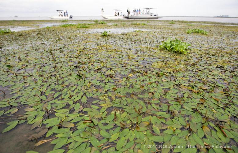


The stems of wetland plants formed a stubble across a wide swath of newly-created mud flat at the southern end of the Wax Lake Outlet near Morgan City, part of a new delta fed by the Atchafalaya and Red rivers along the center of Louisiana's coast.
An alligator floated just offshore Tuesday morning, as a group of state scientists and members of environmental groups explained how this growing delta represents the only significant addition of new land to the state's coastline in close to a century.
They said the new land, more than 18 square miles formed since the early 1970s, is providing hope that man-made sediment diversions along the Mississippi River could produce similar results by 2035, as predicted by the state's coastal Master Plan. It's also helping scientists design diversions to try to rebuild land elsewhere in the state.
"This is a diversion much more ambitious than what we've planned for the lower (Mississippi) river," said Paul Kemp, a coastal oceanographer and geologist and adjunct professor at Louisiana State University, as four boats gathered at the edge of one of the older islands formed by the sediment.
"The channel for the Atchafalaya River is 35-40 miles away. Sediment is coming that distance and crossing the Intracoastal Waterway to get here," he added.
Kemp also is a member of the board of the Southeast Louisiana Flood Protection Authority-East.
The sediment must first be washed through a 15-foot-deep lake before it drops down into a 120-foot hole near the end of the Wax Lake basin. Then it enters a 60-foot-deep channel until the channel slowly becomes more shallow near the new coastline, Kemp said.
"If we tried to design (a diversion) like that, they would say we were crazy," Kemp said.
The outlet was first dredged in 1941 to reduce spring flooding in Morgan City, which sits just to its east. But it was the 1973 Mississippi River flood that kicked off the ongoing delta growth.
By 1973, the diversion had filled a significant amount of the low land in its 60-mile journey to the coast. It carries 30 percent flow of Mississippi River water and sediment that comes down the Atchafalaya Delta from the Old River Control Structure north of Baton Rouge, combined with similar water and sediment from the Red River to the west.
Eventually, the bay at the end of the outlet became shallower, and then islands began to form. The new land continues to grow at a rate of about 4/5 of a square mile per year.
A bit north of the mud flat, a series of triangular islands are fronted by thick growths of willow trees on their northern end, far enough from the coast today for their roots to hold against frontal systems and hurricanes on higher ground that didn't exist a half-century ago.
"There's a lot of data that's been gathered on the delta here and all of that information is going into the tools we're using now to evaluate the diversions we are planning," said Bren Haase, assistant administrator of the Coastal Protection and Restoration Authority overseeing its diversion projects, and a wetland ecologist.
He said the information is being used to validate several computer models that planners are using to determine the potential land-building and environmental effects of the proposed diversions.
He said the planners are being mindful of significant differences between the Wax Lake delta-building and diversions proposed along the Mississippi. Unlike Wax Lake, where the water and sediment can travel long distances before entering the Gulf and forming land, the Mississippi diversions will receive water and sediment directly from the river.
"So, while the results -- what we see here -- is what we think we can achieve, the implementation may be different," Haase said.
But the success of Wax Lake Outlet is still promising.
"If this can happen on accident, what are the possibilities that we can plan and implement one of these things to try to do this?" Haase said. "That's the take-home message."
A key benefit to the Wax Lake land building is that the new wetlands it's creating are helping to reduce nutrients carried from the Mississippi that enter the Gulf, said Chris Macaluso, director of the Theodore Roosevelt Conservation Partnership's Center for Marine Fisheries.
The effect is not enough to halt the annual low oxygen dead zone that forms each spring off the state's coastline. But the new delta, with its shallower open water areas intermixed with new islands and mud flats, provides refuge from low oxygen for a variety of fisheries, he said.
"The nutrient-rich water gets out and mixes with the warm salt water and you get an algae bloom that, when it dies and sinks, it sucks the oxygen out of the lower part of the water column," Macaluso said.
"But there's a misconception that everything in the dead zone is dead. Yes, probably a quarter of the water column (offshore) is depleted of oxygen because of the decaying algae blooms," he said. "But you don't see that in the interior marshes. You don't see that where you've got freshwater interacting in a marsh setting."
Just like in the Wax Lake area, that's true at the site of the controversial Caernarvon Freshwater Diversion on the east bank of the Mississippi in Plaquemines Parish.
Built to freshen outer wetlands along the parish to increase production on public oyster beds, the diversion has been blamed for low oyster production on privately leased state water bottoms closer to the river during years when it is opened to its maximum extent.
Critics have said increases in nutrients in those areas from the proposed diversions will add to those oyster woes.
But Macaluso says Caernarvon's operation is telling a different story. After water from the diversion enters the square-shaped Big Mar, "the next place that gets Caernarvon water is Lake Lery, and there are crab traps from one end of Lake Lery to the other," he said. "If there was a dead zone on the bottom of the lake, there would be no need to put crab traps on the bottom of that lake. There would be no crabs."
Kemp said the benefits of diversions extend to surrounding marshes and islands far away from their targeted land-building areas. He noted that around Atchafalaya Bay, healthy salt marshes and brackish marshes are being sustained by mud carried to the bay that comes into the bay from the outlet.
"So you have this big rim around the bays that is essentially keeping up with sea level," said Kemp.
Captain Ivy St. Romain, owner of Blu Rebel Charters & Guide Service in Morgan City, said the outlet's land building, combined with improved fisheries management practices also has helped fisheries, despite the amount of fresh water it delivers to the coastal area.
"We used to go out and fish all day and maybe catch two or three reds," St. Romain said, referring to red drum, which tend to prefer brackish to salty water. "Now you can go out for an hour and come back with a couple of limits, they're so plentiful."
He said that in addition to fishing rules that have limited catches during some years, the silting that is creating new land has also created new fisheries habitat.
"You can actually go out and there's places you didn't have before," he said. "Your fish have places to hide. And there are lots of crab and lots of shrimp and they're all coming in."