

Sure, that’s your office cubicle. Your corner store. Maybe even the layout of your furniture in your living room. But that doesn’t mean that soon we won’t all be peering at it, too.
That is because two trends, location technology and crowdsourcing, may soon converge. If they do, our indoor lives will be mapped much as street addresses are today, challenging both conventional business practices and human intimacy.
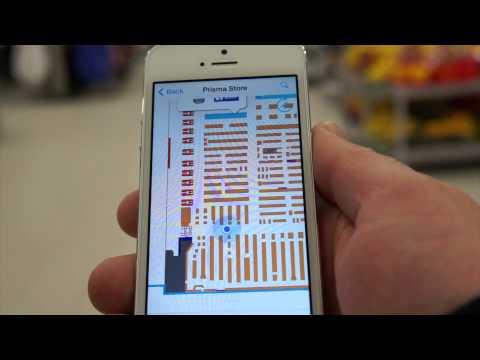
A Finnish company called IndoorAtlas has figured out that all buildings have a unique magnetic “fingerprint” — and has solved how to use that to determine locations inside a structure to within six feet. That is enough to take a consumer to a product in a crowded supermarket, or figure out the location of, say, a half-dozen workers in a building full of them. It’s also much better than cell phone towers can do.
The reason for the fingerprint is that the steel in buildings distorts the Earth’s magnetic field. Different amounts of steel, and changes in the magnetic field at different points on the globe, make each building’s distortion unique. Distance from the ground matters too, so it’s possible to tell when someone is in the same spot in an office, on different floors of a high rise.
IndoorAtlas scans a building to determine its fingerprint (it amounts to walking around a map of the floor plan, which is overlaid on a Google map). After that, anyone can use a smartphone’s compass to navigate the interior.
“The only place where it hasn’t worked so far was a wooden temple without a concrete floor,” said Wibe Wagemans, president of IndoorAtlas. After one scan, he says “everything is stored in the cloud. We can figure out if a store moves shelves by the new ways people walk through a building.”
IndoorAtlas has enjoyed some success selling the service to stores in Finland. In at least one case, shoppers can load their week’s shopping into their phones, and get interior directions about where every product is located, and how to efficiently walk through the store to get everything.
The company is hoping for bigger success with U.S. big box retailers, and hopes also to resell the service in Asia. There are also possible uses for locating things in warehouses and government archives (say goodbye to that “Raiders of the Lost Ark” problem).
The business plan of InsideAtlas is somewhat unorthodox: It will measure and store your building’s magnetic fingerprint in its computing cloud. Keeping it private, however, will cost $99 a month, per building. “It’s free if you want it public,” he said.
Moreover, he expects that soon enough other versions of magnetic fingerprinting will happen, and that crowds of individuals will contribute indoor information to public databases. “There is no reason we couldn’t walk through stores and do that, but we want to stay on good terms with retailers,” he said. “We do think there will be crowdsourced readings. It will create new use cases for us.”

Certainly, we’ve seen this kind of development already for our open public spaces. OpenStreetMap is an open source project that has, since 2004, been working on a editable online map of the world’s streets and other features, in a style something like Wikipedia. It is possible to add things to it like restaurant reviews or nearby parking.
Maps of building interiors, combining the visual logs of OpenSteetMap and the magnetic fingerprints, seem like something that could be easily cobbled together. At that point, a person could get directions that extend all the way to how to walk right to a person’s cubicle.
A company called Waze has been providing real-time traffic and driving directions, based on submissions by other users. Google bought Waze in 2013. Perhaps it could include real-time info on which elevators are working, or whether the burrito lady is grumpy.
All sorts of other information is moving to turn maps from static to dynamic objects. This week a company called Urban Engines started offering a way cities can see how heavily its buses and subways are being used, and how long people are waiting for transport, based on looking at fare card activity. Euclid Analytics and others look at foot traffic in places like malls, based on Wi-Fi signals to smartphones.

“The world is going to be incredibly optimized,” said Simon Thompson, the director of commercial relations at Esri, a company specializing in geospatial analysis. It already uses maps for predictive policing, forestry management and disaster preparedness. In the future, he said, “indoor knowledge will become a resource. Hospitals will manage equipment better. Sports stadiums will know where to put the beer taps.”
In an early case, ESRI mapped movements of shoppers in Melbourne, Australia, in a shop featuring out-of-style jeans. Twenty-two percent of people walking into the store immediately turned in the other direction. Two percent headed for them.
“Location is the new cookie,” Mr. Thompson said, referring to the software in a browser that tracks the websites people visit. “Stores will send sales associates into displays where people are lingering. Apartments will shrink, and re-use space better.”
It may be a smaller world, right down to the four walls of home, but there will be a lot more data collectors in it.