This week NASA will meet with officials from the California Department of Water Resources to talk drought.
The space agency tracks the levels of underground aquifers using satellites.
It plans to advise the state on how to keep those crucial water supplies from getting too low.
Related: NASA to focus on Earth in 2014 (photos)
But how exactly does a satellite in space monitor something as deep underground as an aquifer?
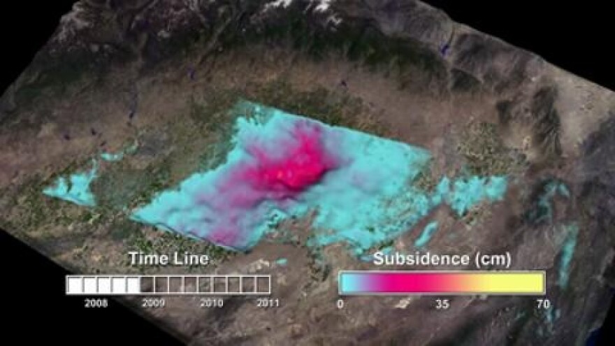
NASA geologist Tom Farr says one way involves sending radar signals down to earth. These signals can measure changes in surface elevation.
"As you pump water out of an aquifer the ground actually does subside or sink," Farr said, adding that when it rains and aquifers fill up the ground rises slightly.
In dry periods when more water is pumped, the ground can sink anywhere from a few inches to several feet, as the animation above demonstrates.
In fact, Farr says in the early 1950s, California drained aquifers in the Central Valley so much that the ground above one sank about 50 feet.
Another way NASA monitors groundwater levels is by measuring the mass of the Earth at various locations.
This approach relies on cleverly titled mission -- the Gravity Recovery and Climate Experiment, or GRACE for short.
It involves two satellites orbiting the earth that measure changes in gravity on the planet below. Scientists know that slight variations in gravity indicate a change in the mass of the planet at a given point.
They then subtract any mass from the region that may have come from falling snow or other surface phenomenon, and the change that's left can usually be attributed to a depletion of groundwater.
Both of these methods are important because draining too much water from an aquifer can undermine its ability to store more water.
“The aquifer system collapses to the point where it can no longer take in water," he said. "So you actually lose the ability to store water if you pump too much and it collapses too much.”
Farr added that as water levels drop and land areas sink, infrastructure like train tracks and aqueducts can be damaged.
These are some of the scenarios officials hope to avoid as the state continues sucking out water from underfoot.
NASA will be in Sacramento discussing these issues with the DWR Tuesday and Wednesday this week.