Charlottesville Fire Department Tracks Fire Hydrant Inspections with an All-in-One Mobile Work App
Paper-based fire hydrant inspections are now passé at the Charlottesville Fire Department in Virginia, having been recently replaced by a digital process that uses the ArcGIS Field Maps app.
In the past, firefighters took notes on paper detailing what repairs were needed to the hydrants and sent emails and made telephone calls to the city’s Public Works division to get the repairs done. This workflow was time-consuming.
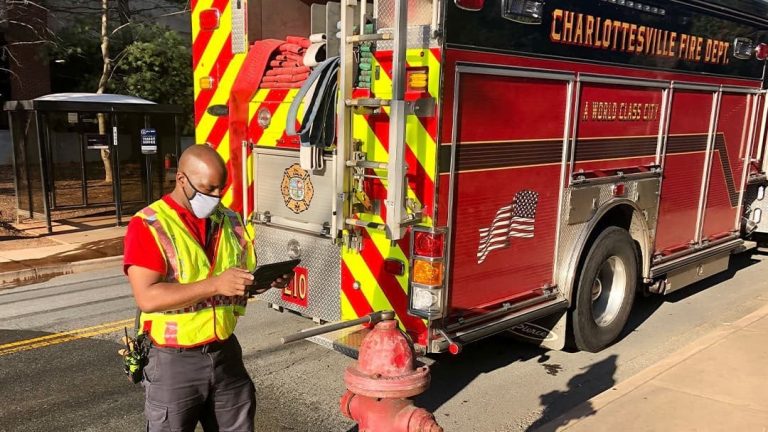
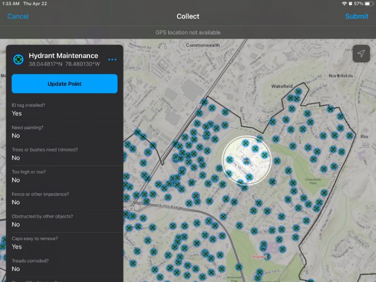
Today, it’s much easier and faster to complete the inspections. Firefighters assigned to the task use the ArcGIS Field Maps app to capture the hydrant’s location along with inspection information such as whether it passed or failed. If the hydrant failed inspection, the firefighter can note on the app’s form the reason for failure (e.g., hydrant cap difficult to remove, other objects are obstructing the hydrant, the hydrant needs paint, bushes or trees around the hydrant need trimming). If needed, photos and attachments can be added to the form, too. When the firefighter finishes the inspection, a feature layer in the city’s ArcGIS Online organization is updated with that information.
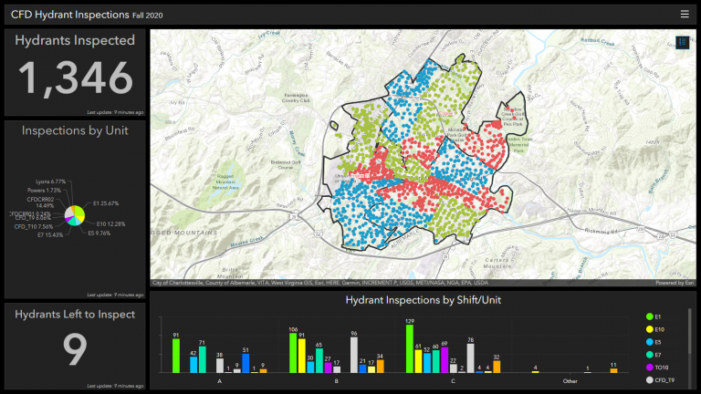
Using ArcGIS Dashboards, two dashboards were created—one for the Charlottesville Fire Department and the other for the Department of Public Works—that display the latest hydrant inspection information. Staff in Public Works, for example, can see at a glance which hydrants have been inspected and which ones have not been inspected. By clicking on the symbol for a specific hydrant on the map in the dashboard, they can see the information the firefighters submitted on why a hydrant failed inspection and send a team out to fix the issues.
The rollout of Field Maps has been a success. “I think it’s a game changer for the fire service,” said Joe Powers, MPA, CFO, who is deputy chief of community risk reduction for the City of Charlottesville. “It allows firefighters to record information and collect data [with one application].”
Hydrant Inspections Needed for Accreditation
Charlottesville Fire Department serves and protects the residents of Charlottesville and the students, faculty, and staff at the University of Virginia by providing comprehensive fire response, hazmat, and emergency medical services.
Accreditation is one aspect of delivering superior services. The model set forth by the Commission on Fire Accreditation International requires fire departments to foster an environment of continual improvement and sets the fire department apart by affirming that it meets the highest standards of excellence.
As an additional layer of review, the Insurance Services Office (ISO), a subsidiary of Verisk Analytics, creates ratings that calculate how well equipped fire departments are to put out fires in a community. The City of Charlottesville has a Class 1 ISO rating, which is the highest ISO rating granted by this body. One requirement necessary to uphold this rating is an annual inspection of fire hydrants within the Charlottesville city limits and at the University of Virginia.
After the Charlottesville Fire Department reorganized in the summer of 2020, Powers began to manage the department’s ISO rating and the different requirements needed to maintain it, including fire hydrant inspections.
The previous inspection method was a manual process that involved firefighters printing a spreadsheet with a list of fire hydrant locations, inspecting the hydrants in the field, and recording the findings on a piece of paper.
The firefighter conducting inspections would then transfer the findings to a form and email it to the Charlottesville Public Works division, which maintains the fire hydrants. The firefighter would then follow up with a phone call to confirm any needed repairs. The public works department would then create a work order to complete the fixes.
In an effort to move away from the manual inspection process, Lucas Lyons, a systems performance analyst for Charlottesville Fire Department, created a digital hydrant inspections process using a mobile data collection app. However, the app had limitations and didn’t allow for advanced enhancements or features.
According to Lyons, the digital hydrant inspections process was adequate, but firefighters were asking for changes that would have required a developer to make. “I found we quickly hit walls, and I became somewhat frustrated by the limited features within [the app],” Lyons said.
Also, the City of Charlottesville uses a spatial database to organize all the data in the city, but according to Lyons, user permissions were a challenging obstacle.
“We have a master hydrant point file, and I had no ability to edit that and neither did the firefighters,” Lyons said. “It kind of took some lobbying to get access to things like that. The database is just a legacy system. It’s not very open and editable, making collaboration difficult.”
With improvement needed in the digital inspection process, Powers began to search for a more efficient method that would save the firefighters valuable time and enable them to more expediently complete inspections.
Charlottesville Fire Department Collaborates with Esri
To establish an easy and efficient method that was simple for firefighters to use, Powers began working with Renee Bernstein, public safety solution engineer at Esri, and Mike Cox, director of fire and emergency medical services (EMS) solutions at Esri. Cox and Bernstein suggested testing a new product that would streamline hydrant inspection: ArcGIS Field Maps. ArcGIS Field Maps is an app designed to enable mobile workers to view their organization’s digital maps, collect and edit data, and capture location tracks.
Powers wanted to tie in the hydrant record with the inspection performed and move away from a paper-based process, so the combination of capabilities—like mobile data collection and editing—seemed to be exactly what the department needed.
“We knew Charlottesville had obstacles it was trying to find solutions for. We also knew that Chief Powers and Lucas [Lyons] were pretty progressive and would . . . be good storytellers for the use of technology to improve day-to-day operations,” Cox said. “So it just seemed like a perfect fit for an early rollout of Field Maps to a fire department.”
Bernstein recalls that Powers and Lyons indicated that some Field Maps app users might not be familiar with GIS or Esri and would need a simplified process. “When you can simplify everything you need into one application, like Field Maps, that’s a huge thing,” Bernstein said.
Lyons created the solution with just a feature layer of the hydrants, and the app has inspections grouped by A, B, and C shifts and by unit, enabling firefighters to see what inspections other shifts have completed. Lyons made it a priority to ensure that all the work was divided equitably among each shift. Also, the zones are color coded to provide quick information at a glance; for example, green zones include hydrants that have already been inspected.
“With Field Maps, you have a way to collect data without having to go through this whole process of [asking], Where should this data live? You just need to set up a feature layer, and you’re good to go—and I like that,” Lyons said. “I think we’ll have more and better data in the future [by] having an application like this in users’ hands.”
After Powers and Lyons received some Field Maps training from Esri, Powers used a teleconferencing service to create a three-minute training video to educate the firefighters on Field Maps. The video showed Lyons using the app and walking through a hydrant inspection, and the fire department’s normal documentation for inspections was included with it. Powers said the app was so straightforward that firefighters were out inspecting hydrants using an iPad or mobile device the same day they received the training.
A Simple-to-Use App
Since the successful implementation of Field Maps, the Charlottesville FD has plans to deploy it every year in May to inspect city fire hydrants. Charlottesville firefighters have been able to expediently inspect all the hydrants—which number more than 1,300—even with schedule limitations, such as no inspections on weekends. According to Powers, the streamlined process has helped decrease the workload while still increasing productivity.
“Almost all of our fire departments have some sort of mobile technology, either in their pocket or in the front seat of a fire truck, and we can deploy Field Maps on those pieces of technology,” said Powers. “And [firefighters are] done with collecting data before they get back to the station. We had the opportunity through Field Maps to refine our entire process and make it firefighter-friendly.”
The simple deployment of Field Maps was an added benefit of using this all-in-one mobile work app. Lyons said Field Maps was a strong app to begin with, so he and Powers were confident they were launching a solution that would work.
“We made a few little tweaks to [the app] once we were out on the street testing hydrants. Then we deployed it to our firefighters, who were testing hydrants within hours, and there were very few questions. It’s relatively simple,” said Lyons.
The simplified digital inspections process has also saved valuable time for the firefighters, allowing them to perform other activities. Powers said the daily calendar of a firefighter is filled with everything from hazmat training to physical fitness and online training. And with the added responsibility of hydrant inspections, it takes them out of the firehouse and away from other tasks. Now, with a streamlined process, firefighters can more easily do the inspections and move on.
“From a staffing perspective, my fire [crews] are not spending as much time on the street doing hydrant inspections because they’re not writing it all down,” Powers said. “They’re doing it one time, and it’s done. They can do other activities rather than sitting there doing emails, making phone calls, and scanning paper work.”
He added, “When you say we’re going to increase your productivity and save you time, it’s almost a pipe dream. But with Field Maps and the hydrant inspections, that’s exactly what we did.”
The ability to visualize hydrant inspection data in real time and see where hydrants were being inspected, and by what crews and shifts, was another significant benefit. Seeing all completed inspections eliminated the duplication of work because it was easy to see work that had already been done. Lyons said that building the online dashboard, which helps organize the information, was an intuitive process that only took an hour because of the reliable data. Previously, dashboards created with a different data visualization program took from two to four hours.
“In the past, administrators and the crews didn’t have that kind of insight, said Lyons. So it was just when the last hydrant was inspected and that form was turned in, then the whole process was done. But now we can track in real time how that’s happening using dashboards.”
The real-time updates with Field Maps have also improved communications with Charlottesville Public Works. The data collected in Field Maps and the documentation of inspections are given to the public works department in real time, which allows staff to more quickly create work orders for repairs.
The Charlottesville Fire Department plans to expand its use of Field Maps, including using it to track the installation of free smoke alarms through a city program. Powers believes that from an administrative level, team members have gained a huge amount of organizational equity because they saw the opportunity to improve an inefficient process for firefighters.
“One of the big benefits is the goodwill of our workforce [members], who now believe in technology and see it can work. Whenever we can show a win and show that life is easier with technology, that’s good, because that hasn’t always been the case,” Lyons said.
About the author