My last series of blog posts explained some of the challenges facing Montgomery County’s economy. I discussed how encouraging walkable, compact, mixed-use development can help us grow our tax base, control housing costs and improve the quality of life for all our residents. This “New Suburbanism,” however, is about more than economic competitiveness. It helps in addressing our most challenging environmental issues, including climate change and pollution from vehicle emissions and stormwater runoff.
Take a look at these charts from the Planning Department’s most recent Mobility Assessment Report:
Between 2005 and 2015, Montgomery County grew by more than 100,000 people. While our total vehicle miles traveled (VMT) has increased in the last few years as our population and jobs base have grown, our per capita VMT was in a steady decline for years and has only recently begun to tick upwards again. What’s happening here?
Well, here’s a map you may have seen before:
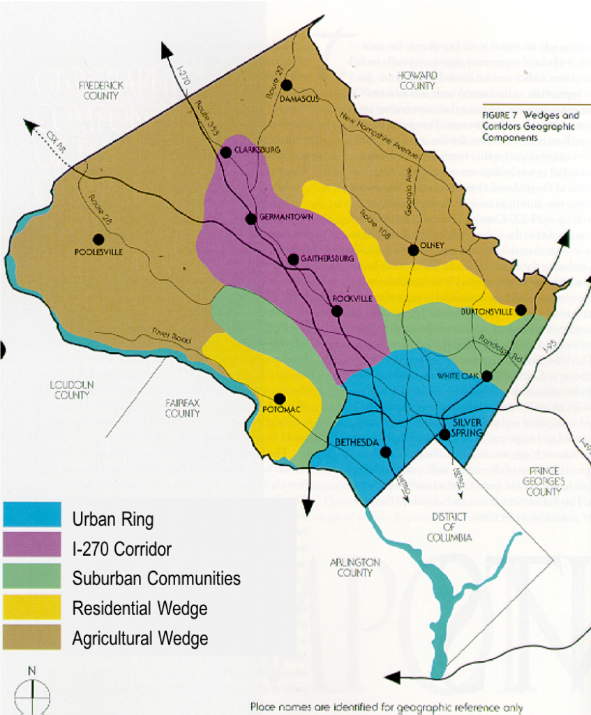
Wedges and Corridors Geographic Components, from Montgomery County’s 1964 General Plan: “…On Wedges and Corridors”
Montgomery County’s 1964 General Plan, commonly known as the “Wedges and Corridors” plan, calls for the most intensive development to be focused in the “urban ring” (most of the area south of Randolph Road) and the I-270 corridor with the “residential wedges” and “suburban communities” set aside for lower density, single-family development.
The outlying parts of the county were intended to remain devoted mainly to agriculture. Eventually, this idea was reinforced via the creation of the Agricultural Reserve, which establishes a set of incentives and land use controls limiting development and encouraging farming within its boundaries.
Compare the 1964 plan map with this map showing daily household VMT by policy area:
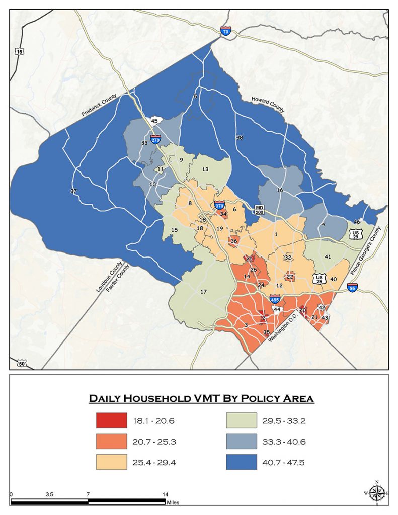
Daily Household Vehicle Miles Traveled By Policy Area, Source: Montgomery County Planning Department’s Travel 4 Transportation Demand Model, 2010
For the most part, development in Montgomery County has been consistent with the General Plan’s original vision, with density levels highest in the urban ring. If you look closely, you can see that the very lowest VMT households (in red) are located in the areas immediately surrounding Metrorail stations in Rockville, Bethesda, Friendship Heights and Silver Spring. These areas have excellent access to transit and compact development with a mix of uses, so it’s no surprise people who live in these areas drive less than people who live in lower-density areas without convenient access to high quality transit.
But what about the orange areas inside the Beltway and up the I-270 corridor? Households in these neighborhoods have relatively low VMT levels, even though they are not in a central business district or located next to a Metro station. While these households are unlikely to be able to give up their cars, many of their daily needs are still just a short drive away. In contrast, the areas in green and blue are more sparsely developed and in some cases quite rural or exurban – so residents not only need to drive, they need to drive long distances to get to work, school and shopping.
The transportation sector is now the largest producer of greenhouse gas emissions and energy-intensive industries are not heavily represented in Montgomery County, so decreasing VMT by reducing the number and length of vehicle trips is the best opportunity we have at the local level to help solve climate change.
New Suburbanism is also a big help in reducing stormwater runoff, the other major environmental challenge facing local government. Runoff from impervious surfaces (like parking lots, streets and roofs) flows into our streams and rivers, carrying sediment and other pollutants that degrade water quality.
According to the Chesapeake Bay Foundation, stormwater runoff is the fastest growing source of pollution in the Chesapeake Bay (agriculture is another major source of pollutants, and non-point sources such as nitrogen from auto emissions are also important). Maryland has some of the strongest stormwater management rules in the country and these rules require new development (including redevelopment) to use environmental site design (ESD) and best management practices (BMPs) to capture and treat stormwater runoff before it enters our waterways.
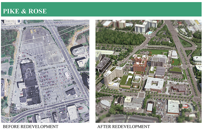
The dramatic impact of these stormwater rules can be seen in these before-and-after images of Pike & Rose, the redevelopment of a strip shopping center on Rockville Pike near the White Flint Metro Station into a mixed-use center that combines residential, retail and office space.
Size: 8.78 Acres
77% Runoff Reduction
Runoff Rates:
Pre-construction runoff: 78,722.36 cu/ft
Treatment Provided: 60,555.66 cu/ft
Post-construction runoff: 18,166.70 cu/ft
On the left is an image of the old strip center anchored by Toys ‘R’ Us. This image shows the massive amount of surface parking – and accompanying expanse of asphalt – characteristic of old school suburban retail development. The site was almost entirely covered with impervious surfaces, so every drop of rainwater that fell on the shopping center and its parking lot carried pollutants, trash and sediment directly into storm drains, streams – and ultimately the Chesapeake Bay.
On the right is a photo of the same site taken last year. When fully built out, the Pike & Rose redevelopment project will include approximately 1.5 million square feet of office and retail space and almost 1800 apartments, condominiums, and hotel rooms. Unlike the strip center it replaced, Pike & Rose was built according to modern stormwater rules, meaning that it must contain or treat stormwater onsite.
The visual difference between the two images is stark. Green roofs, landscaping and small parks are incorporated throughout Pike & Rose, while the old strip center didn’t have a speck of green. The most important differences, however, are in the techniques used to control runoff. These include vegetative buffers, permeable paving and underground wells.
Together, these methods are designed to approximate the stormwater absorption and treatment capabilities of a healthy forest as closely as possible. The stormwater management strategies used at Pike & Rose now provide for the infiltration or treatment of 77% of the rainwater that can be expected to fall on the site during a 2-year storm, or 2 inches of rain in a 24- hour period. This means that almost half a million gallons of polluted runoff that would otherwise be flowing into storm drains and streams after a very heavy rain is now treated onsite. This solution isn’t perfect, but it’s a dramatic improvement over the performance of the old strip center, which had no stormwater controls at all.
Modern stormwater rules ensure that new development on these sites will help reverse decades of environmental damage resulting from an absence of comprehensive stormwater management. In fact, redevelopment of these outdated suburban strip centers covered in acres of asphalt surface parking provides the only opportunity for improving their environmental performance – in the absence of redevelopment it is both economically infeasible and physically impossible to retrofit them with modern stormwater management infrastructure.
In Montgomery County, we have very little land available for greenfield development, i.e., the construction of housing or other structures on property that is currently undeveloped. We do have many older shopping centers and other properties that could potentially be redeveloped to provide needed housing, updated commercial buildings and new parks and open spaces.
Higher-density development in transit-oriented urban areas like downtown Bethesda and Silver Spring and infill redevelopment of suburban strip centers and underutilized parking lots aren’t just good for our economy and quality of life. By dramatically reducing vehicle miles traveled and the volume of polluted stormwater runoff, this kind of compact, mixed-use and walkable development is, overwhelmingly, an environmental net positive.
In my next post, I’ll discuss how constraints imposed by natural features, legal limitations and economic factors shape future development opportunities.
Robert Smythe
Is the Purple Line corridor development required to meet strict standards for retention of storm water on-site, both along the tracks and at the stations?
Casey Anderson
Yes, the Purple Line (and other public infrastructure projects, including the Hogan administration’s proposals to add lanes to I-270 and I-495) are subject to the same stormwater requirements applicable to projects involving private property.