At a Glance
- Invest 99-L developed into Tropical Storm Nine on Sunday evening.
- This system will continue to bring locally heavy rain to parts of Cuba and South Florida through Sunday night.
- Details such as intensity and location of any possible landfall remain uncertain.
Invest 99-L developed into Tropical Storm Nine on Sunday evening. For continued updates on this system, refer to this article.
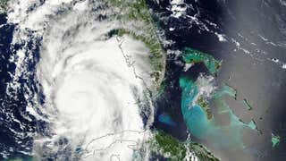
Invest 99-L, a tropical disturbance we've been following for about 10 days, is likely to develop into a tropical depression or tropical storm early this week in the Gulf of Mexico. Residents and visitors along the eastern Gulf Coast and in Florida should continue to stay updated with the latest information on this system the next few days.
Even though this system hasn't developed into a tropical cyclone yet, it has been impactful.
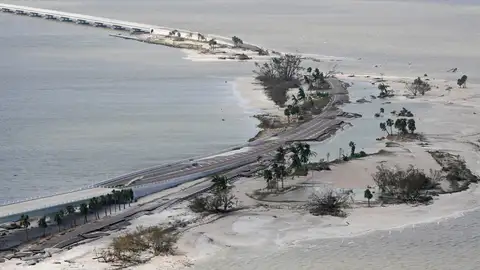
Late last week, more than 1,700 people were displaced from their homes in the Dominican Republic due to heavy rainfall. In the near-term, rain and gusty winds will affect parts of Cuba and far southern Florida through Monday.
(MORE: What is an Invest?)
Wind shear, the change in wind speed and/or direction with height, has hampered any attempt of 99-L to consolidate convection near a surface low-pressure center the last few days.
Wind shear tends to inhibit the development of tropical cyclones by blowing the convection away from any area of low pressure trying to form.
However, Invest 99-L will move into an environment that may have less wind shear early this week, allowing it to develop further.
(MORE: Hurricane Central)
A consensus of our guidance suggests the disturbance should still move west-northwest and then turn more north with time the next several days.
The National Hurricane Center (NHC) says this system now has a medium to high chance of development into a tropical depression or tropical storm over the next 2-5 days.
(MORE: Why Tropical Waves Are Important During the Hurricane Season)
South Florida and Cuba: Rain, Gusty Winds Expected
As mentioned before, the main threat to South Florida and Cuba through Monday will be pockets of locally heavy rain and flash flooding. Winds could be gusty at times, as well.
Some areas will likely pick up over 3 inches of rain, possibly in a short period of time, triggering flooding, particularly in urban areas. Locally, five or more inches of rain could fall in southwest Florida or the Florida Keys.
(FORECAST: Miami | Key West | Tampa)
Parts of Cuba saw 3-5 inches of rainfall on Saturday from heavy thunderstorms associated with 99-L.
The low will pull tropical moisture into central Florida early this week where locally heavy rain is also possible.
Gulf Coast Threat Ahead?
Upper-level high pressure is now established over the East Coast of the United States.
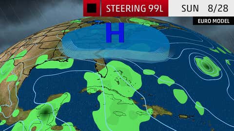
The area of low pressure associated with 99-L will continue to be steered into the southeast Gulf of Mexico by the clockwise flow around this high into Monday.
As mentioned before, atmospheric conditions may become more favorable for development Monday in the southeast Gulf of Mexico, the National Hurricane Center says.
The aforementioned upper-level high is expected to weaken by Tuesday. This will allow the system, and/or its moisture, to get pulled north and then northeast toward the eastern Gulf Coast, potentially moving inland sometime late in the week.
The intensity of any system approaching the eastern Gulf Coast late this week remains extremely uncertain. It could range from an undeveloped low to a tropical storm or even a hurricane.
(MORE: Where Every U.S. Hurricane Has Hit Since 1985 | Record Gulf Hurricane Drought)
Regardless of the system's ultimate intensity, rainfall flooding looms as a significant threat along or near its track.
(MORE: Rainfall Flood Concern for Saturated Gulf Coast)
A rather expansive swath of the Gulf Coast region, not simply Louisiana, but also parts of the Florida Panhandle and Texas, have been soaked in August.
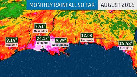
The threat of heavy rainfall is not a function of tropical cyclone intensity, but rather the system's slow movement and availability of deep, tropical moisture, as we saw with an unnamed system earlier this month triggering Louisiana's epic flooding.
Any wind and/or storm surge impacts from this system will ultimately depend on the exact intensity and track of the system late this week.
For now, if you have interests anywhere along the eastern Gulf Coast and in Florida, check back with us at weather.com for any important forecast changes in the days ahead.
(MORE: Most Intense U.S. Landfalls Have Happened in a 17-Day Period)
Regardless of Invest 99-L's future, now is a good time to make sure you have a plan before a hurricane hits.
MORE ON WEATHER.COM: Retired Atlantic Hurricane Names