Benign weather conditions continue as high pressure remains in charge. Still chilliest with the highest risk of frost in the southeast corner.
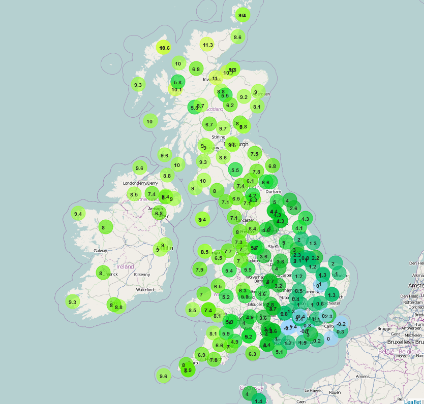
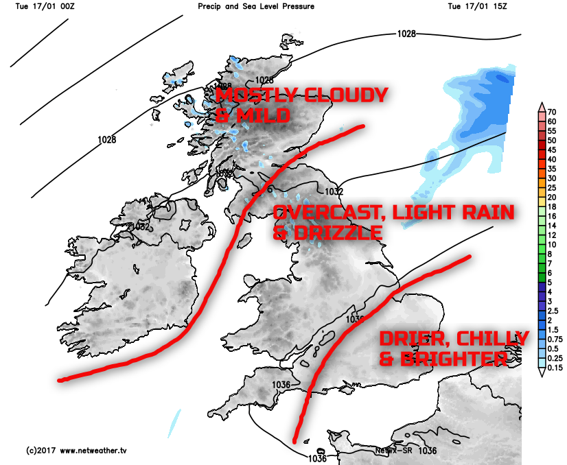
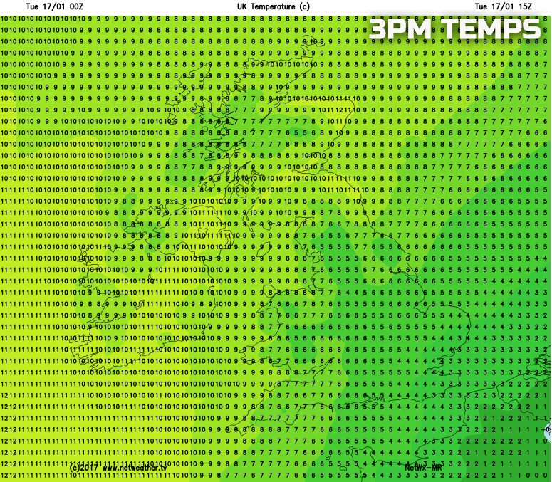
It’s a cloudy start to Tuesday across many areas of the UK as the benign and settled conditions, in association with an area of high pressure, continues to dominate. Some cloud breaks, along with a colder Continental air mass, across SE of England in particular has meant a local frost here and with a minimum temperature of -1C being recorded at Gatwick, Farnborough and Manston for example, whilst other areas of S England have seen minimum temperatures fall near to freezing. In complete contrast though are much milder conditions across the north of the UK with an overnight minimum temperature of 10C at Tiree Island in Scotland, along with many areas in Scotland not having a temperature below 9C. A weak weather front is also in evidence in parts of S Scotland and N England and this will become slow moving here bringing some nuisance value light rain and drizzle throughout the day. Emphasis though is on a lot of dry weather, but clearly with a lot of cloud and some further low cloud and hill fog too, especially across S Scotland and N England in associating with the light precipitation. The contrast in temperature is highlighted well by our observation map from a little earlier.
Through the remainder of Tuesday and it is across SE England that best of the conditions will be. This region of the UK remains near to a colder, clearer air mass over in the near Continent and, as a result, it is here that best of the cloud breaks will be through the day. As a result some bright or sunny spells are possible across E Anglia and SE England after the chilly start. For most of the UK though the story of the last day or so continues and that is for mainly dry, but mostly cloudy conditions to continue and it will remain very mild across the north and west of the UK in particular in association with a SW’ly wind. However, the region of light rain and drizzle is also expected to remain slow moving across parts of N England though the afternoon
Temperatures, as indicated, will be mild or very mild across many northern and western areas of the UK with ‘double figure’ maximum temperatures likely. This will be in contrast to more southern and south-eastern England though where it will be chilly, with temperatures, locally at least, several degrees lower than further north, as highlighted on the below weather chart for mid-afternoon.
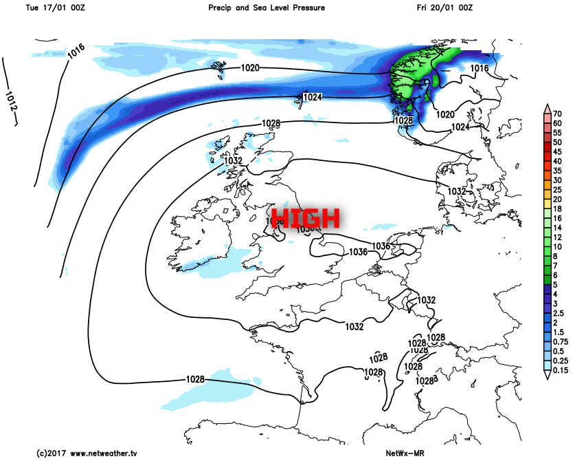
Looking further ahead through the rest of the week and, overall, very little change in the weather is expected. High pressure will continue to dominate across all areas of the UK through the second half of the week in what is known as a ‘blocking pattern’. As a result, day-to-day changes in the weather aren’t expected to be significant, and the main uncertainty is cloud amounts and distribution. It is likely that further cloud breaks will be in evidence though across more southern and south-eastern areas of the UK which will lead to some chilly nights with local frost, but with then some bright or sunny intervals by day. For most of the UK though the outlook is a mainly dry one, with an on-going significant amount of cloud which will, unfortunately, mean further overcast and grey conditions at times. There is some evidence to suggest that across England and Wales at least the somewhat colder and clearer conditions may make some progress northwards to allow for chilly temperatures to develop more widespread across England and Wales, when compared with Scotland and Ireland, perhaps with more of a risk of slight frosts by night too. Our medium range weather model highlights the broader weather pattern well during the end of the week with high pressure dominating keeping weather systems at bay to the north and west.
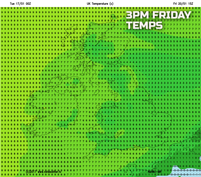
The general trend towards less-mild conditions is highlighted well on the below chart too, again especially across England and Wales, with maximum temperatures for Friday likely to be around 4C to 6C, though still somewhat milder across Scotland and Ireland.
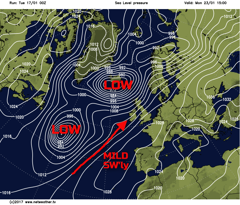
This settled and benign period of weather is expected to continue into the coming weekend as well at the moment, but look further ahead, within the longer term, and there is growing evidence to suggest that during the final week or so of January a change to far more unsettled conditions is likely. High pressure is expected to decline and this allowing a more mobile and active period of weather to develop across the UK, perhaps along with a very mild SW’ly air mass as well, so change is on the horizon, but not for several days yet.