to some kind of ill-defined ownership of all the waters that lie within the famous ‘nine-dash line’.
The judgment has been eagerly awaited by those in the region and beyond — especially in Washington — who hope and expect to see China’s claims rejected by the court. But what difference will the judgment make, even assuming — as most experts do — that it will go against China on the key issues? Beijing has refused to acknowledge the court’s jurisdiction, took no part in the hearings and has repeatedly declared that it will ignore its findings.
Would that do China any harm? The United States, with its friends and allies, think that a formal ruling by an internationally recognised court will increase the moral and diplomatic pressure on China to cease pressing its territorial and maritime claims so assertively. Washington seems convinced that faced with a negative judgment, Beijing would finally decide that the diplomatic damage to its standing in Southeast Asia has become unbearable.
But the most recent evidence all points the other way. In mid-June, China apparently forced ASEAN foreign ministers into a highly embarrassing retraction of a relatively mildly worded joint statement alluding to the South China Sea as ‘an issue in the relations and cooperation between ASEAN and China’. The statement was hurriedly withdrawn just three hours after it was issued. That hardly suggests that China feels the need to start lowering the diplomatic temperature.
Then at the end of June, China allowed tensions to escalate with Southeast Asia’s most important power, Indonesia. Beijing vigorously protested against Indonesia’s robust response to Chinese fishing vessels operating in what Jakarta claims is Indonesia’s exclusive economic zone around the Natuna Islands, but which also fall within Beijing’s nine-dash line claim.
China’s reaction in turn prompted surprisingly stern actions from Indonesia. President Joko Widodo ordered the Indonesian National Armed Forces (TNI) to deploy more forces to the region and made a high-profile visit there himself with senior Cabinet ministers to underline Jakarta’s seriousness. But Beijing doesn’t seem too worried.
Again, there is no sign here that China’s leaders are starting to feel the diplomatic pressure.
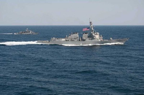
And that raises the obvious question: what happens next if China simply ignores the court’s ruling? In particular, what does Washington do? Clearly Washington is prepared for trouble. Over the last few months, it has responded to what it sees as Beijing’s destabilising militarisation of the situation by sending substantial new forces of its own into the region. This has culminated in the deployment of two US aircraft carrier strike groups off the Philippines.
This is the biggest overt display of US military power in the Western Pacific since it sent two carriers to face down China in the Taiwan Crisis of 1996. It is plainly intended to send an unmistakable message of Washington’s resolve.
But resolve to do what, exactly?
Let’s look at two scenarios. In one, China does nothing more in response to the court’s judgment than issue a strongly worded rejection. It does not back off from anything it has been doing, but takes no immediate, overt additional steps to expand its presence or strengthen its position in the contested areas. In this case, without any provocative Chinese actions to respond to, it is hard to see what the United States could do with all the military force it has assembled.
In the other scenario, China decides it has to make a more forceful response to an adverse judgment in The Hague. For example, it might announce the imposition of an Air Defence Identification Zone over the South China Sea, the way it did in the East China Sea in 2013.
Or it might start to build an artificial island and create a new base on Scarborough Shoals, as it has done on other features in recent years. China seized Scarborough Shoals, which lie quite close to Manila, from the Philippines in 2012.
The United States has plainly warned China against taking either of these steps, and its big military deployments are obviously designed to back these warnings up. They appear to send the message that the United States would be willing to meet with armed force any move by China to further extend its hold in the South China Sea.
That kind of none-too-subtle threat worked 20 years ago over Taiwan. But back then, China had no credible way to sink a US carrier, and the economic costs of a rupture with Beijing seemed manageable. Things are very different now: any military clash with today’s well-armed and economically vital China would carry almost incalculable strategic risks and economic costs.
It is hard to imagine the cool and calculating President Barack Obama accepting such costs and risks. That a new president will be elected in November and will take office in the White House in January 2017 merely adds to the uncertainty for Washington.
That means the threat implied by high-profile US military deployments may just be a bluff. And this raises the question: what happens if Beijing tries to call Washington’s bluff, and presses ahead with a highly provocative move like those mentioned above?
Washington would then face a disastrous choice. Either it backs down, thereby acknowledging China’s growing regional ascendency and the corresponding decline of US leadership, or it launches into an armed clash which might well escalate into a major conflict. Would Beijing risk this by calling Washington’s bluff?
Well, let’s hope not, but the possibility is there, and it makes the situation potentially very dangerous indeed.
Hugh White is Professor in the Strategic and Defence Studies Centre at The Australian National University.
A version of this article first appeared here on The Straits Times.
Professor White refers to Indonesia’s ‘claim’ to an EEZ around the Natunas. Rather than simply a claim, Indonesia appears rightfully to have such an EEZ. Does Professor White dispute Indonesia’ the simple fact that Indonesia has sovereignty over the Natunas? Even China doesn’t do that.
The only ‘claim’ in the fishing vessel issue is China’s claim that its fishermen were harvesting fish in a traditional fishing ground. Such a claim is contrary to UNCLOS. China may negotiate the exercise of traditional fishing rights in the area by means of an agreement with Indonesia, which Malaysia, for example, has done.
Some day, Professor White should offer us his analysis of the implications of the nine-dash line, if possible without mentioning ‘Washington’ a single time.
Professor White’s assertion that allegedly “China seized Scarborough Shoals, which lie quite close to Manila, from the Philippines in 2012” is seriously flawed and thus has no merit.
If he cares to revise the 1898 Treaty of Paris, the 1900 Treaty of Washington and the 1930 Convention between the United States and Great Britain, he will discover that they described the western limit of the Philippine territory as 118 degrees East longitude.
But as the map shows, China’s islands and reefs in the Spratly, Paracel, Pratas, Zhongsha, which include the Macclesfield bank and Huangyan Dao (Scarborough shoal) are all due West of that 118 degrees East longitude
The 1982 UN Convention on the Law of the Sea (Unclos) deals with the law of the sea only and not law of the land. It does not have any power pertaining to matters concerning sovereignty or delimitation of maritime boundary.
After a 12 year negotiation to remove Unclos’s power over sovereignty and to allow states to declare that they exclude compulsory arbitration on delimitation under Article 298, Unclos came into force in 1994 but it did not award the Philippines or any littoral state with any island or features or shoal it did not own prior to 1982 as it has no such power to do so.
On 28 April 1952, Japan returned the Spratly and Paracel back to the ROC, under the Treaty of Peace, by extension to China under the one-China policy, recognized by Asean, Australia, the US, Japan and Russia.
“China’s Declaration on the territorial Sea, promulgated (on 4 Sept) 1958, says in part,
The breadth of the Territorial Sea of the People’s Republic of China shall be twelve nautical miles. This applies to all territories of the People’s Republic of China, including the Chinese mainland and its coastal islands, as well as Taiwan and its surrounding islands, the Penghu Islands, the Dongsha Islands, the Xisha Islands, the Zhongsha Islands [italics added], the Nansha Islands and all other islands belonging to China which are separated from the mainland and its coastal islands by the high seas. (Wikipedia).”
On 14 Sept, Prime Minister Pham Van Dong wrote a letter to Premier Zhou Enlai to acknowledge that “the Government of the Democratic Republic of Vietnam recognizes and supports the Declaration of the Government of the People’s Republic of China on China’s territorial sea made on 4 September 1958.”
Later, Mr Pham tried to explain his so-called alleged ‘wrongdoing’. That was published in the 16 March 1979 issue of the ‘Far Eastern Economic Review’, in which he said that the reason he did what he did was because it was ‘wartime’.
But it was already on record that on 15 June 1956, Mr Pham Van Dong said “From the historical point of view, these islands are Chinese territory” (See the Beijing Review 30 March 1979, p20 and the Far East Economic Review,16 March 1979, p11).
The Philippines, Malaysia, the US, Japan, Australia did not object to China’s 12nm territorial water Declaration in 1958.
It was the corrupt President Ferdinand Marcos who annexed 8 features in the Spratly on 11 June 1978, using Presidential Decree 1596, under the pretext they were terra nullius, which had no basis under any law.
The Philippine navy even ran aground an old rusty Navy ship on Second Thomas Shoal to stake its illegal claim and yet China had acted with restraint and wanted to negotiate with the Arroyo and Aquino administrations for a win-win solution but they betrayed China. Aquino took China to the Permanent Court of Arbitration at the Hague, which, paradoxically, has no power to decide on sovereignty or matters relating to delimitation (maritime boundary), already declared by China in 2006.
The Philippines’ claim to the Scarborough shoal was based on the false premise that it lies within the EEZ of the Philippines. This is a logical fallacy because if it were true then the Singapore island, which lies only 3 nm from the southern coast of Malaysia, could also be claimed by Kuala Lumpur. This is not true.
The truth is when Unclos came into force in 1994 it did not award any littoral state like the Philippines with any island or reef or shoal within its EEZ.
If another nation owns an island in the EEZ of another nation then the resultant maritime boundary is equidistant from both baselines under Article 15 of Unclos.
China owns the Spratly and Paracel (returned by Japan in 1952) as well as the Pratas and Zhongsha group (which include the Macclesfield bank and Scarborough shoal).
And post 1994 Unclos, the Philippines has no legitimate claim over the Scarborough shoal.
Excuse me KTTAN, but you seem to be trying to make some sort of argument based on many faulty assumptions and incorrect historical fallacies.
For example, you seem to have assumed that the Philippines was a signatory of the 1898 Treaty of Paris, the 1900 Treaty of Washington and the 1930 Convention between the US and UK, and should somehow still abide by these documents. If the Philippines did this, it will actually enlarge its territorial sea much farther out, beyond the 12-nautical mile limit set by UNCLOS. You seem to be ignorant of the fact that the Philippines have long replaced its 1935 Commonwealth Constitution, which did feature the boundaries set by the Treaty of Paris, and have long since enacted its Republic Act (RA) 9522 Baselines Law, which places its maritime territorial boundaries in line with UNCLOS.
You also seem to have assumed that the outlandish rumour that the Treaty of Paris or Treaty of Washington or Convention between the US and UK actually placed the “western limit of the Philippine territory at 118 degrees East longitude.”
This is of course, a complete fallacy.
Anyone can Google the treaties and convention that you tried to cite, albeit sloppily, to find for themselves that none of them placed the “western limit of the Philippine territory as 118 degrees East longitude.”
Yes, the 118th meridian east was mentioned a number of times, though not as the “western limit of the Philippine territory,” but rather as belonging to a set of coordinates creating a polyline running east-west and north-south of the archipelago, going as far west as the 116th meridian east, demolishing your argument.
Anyone with the most basic knowledge of cartography would have easily realized that if the western limit if Philippine territory was the 118th meridian east, this would cut the Philippine island of Palawan in half. Anyone can Google 118th meridian east to verify this for themselves.
It should also be remembered that the 1900 Treaty of Washington explicitly provided that: “Spain relinquishes to the United States all title and claim of title; which she may have had at the time of the conclusion of the Treaty of Peace of Paris, to any and all islands belonging to the Philippine Archipelago, lying outside the lines described in Article III of that Treaty,” thereby increasing the amount of Philippine territorial sea than previously described in 1898.
So are you actually arguing that the Philippines should be entitled to more territorial seas than what has been set in UNCLOS?
The above are just a few examples of the many fallacies that need to be rejected in your very long post. Readers would therefore be very well advised to check the veracity of the rest of your supposed “facts.”
Thank you.
1 Whether the Philippines was a signatory of the 1898 Treaty did not matter as it was a colony of Spain and then the US.
2 Under Article III the coordinates described the boundaries. It did go to the 116th for a few degrees parallel before going back to 118th for most of the degrees parallel. That is why most people refer to the 118th, rather than the 116th.
3 When a Philippine ex-Senator wanted to annex the Spratly in 1933 this was what the US Secretary of State Cordell Hull, wrote on 20 August 1933, stating that, “the islands of the Philippine group which the United States acquired from Spain by the treaty of 1898, were only those within the limits described in Article III”, and that, referring to the relevant Spratly islands, “It may be observed that […] no mention has been found of Spain having exercised sovereignty over, or having laid claim to, any of these islands”.
Why did he not mention the 1900 treaty?
4 So in August 1933 the Philippines did not own any of the Spratlys, despite the 1900 treaty giving it more territorial space but are you claiming that, by a miracle, in 1994 when Unclos came into force the Philippines started to own the Spratly?
Can Unclos award the Philippines with the Spratly Islands or was it due to annexation via Marcos’ Presidential Decree 1596 and named them the Kalayaan Islands Group?
5 Can you give coordinates to show how the Republic Act (RA) 9522 Baselines Law placed its maritime territorial boundaries in line with UNCLOS?
The author writes:
“Then at the end of June, China allowed tensions to escalate with Southeast Asia’s most important power, Indonesia. Beijing vigorously protested against Indonesia’s robust response to Chinese fishing vessels operating in what Jakarta claims is Indonesia’s exclusive economic zone around the Natuna Islands, but which also fall within Beijing’s nine-dash line claim.”
Clarification: No, the Natuna islands do not fall within Beijing’s nine or ten (or nth) dash claim. What Beijing is trying to project is the perception that its (i.e., China’s) maritime boundaries overlap with Indonesia’s. By doing this (and sending from time to time its Coast Guard), Beijing is trying to establish that “fait accompli” that its maritime boundaries really overlap with Indonesia’s. Of course, this can only happen IF Beijing’s 9/10/nth dash line claim has basis in international law.
In view of the Tribunal’s decision, now, why will there be an overlap?
I think what needs to be clarified is who decided that the Natuna Islands have a 200 nm EEZ? Is it Unclos or is it a unilateral proclamation by the Indonesia Govt?
If it is by the latter is it legal?
If the tribunal declared on 12 July that no feature in the Spratly (including the 46 ha Taiping island) is an island according to Article 121 (3) and therefore do not qualify for a 200nm EEZ why should that not apply to the Natuna islands as well?
The US unilaterally declared that Baker and Howland islands in the South Pacific which are uninhabited, with no fresh water and are now bird sanctuaries, have a 200nm EEZ though the US has not yet ratified Unclos.
Does it mean that under Article 121 (3) of Unclos, these two uninhabited US islands qualify for a 200 nm EEZ too? Hardly.
Therefore, in my humble opinion, as a result of the tribunal’s cavalier ruling, the maritime boundary of the Natuna islands is now questionable.
@KTTAN: Why do you find the “need” to have the Natuna Islands’ status clarified when it is not located anywhere near any competing claims?
Itu Aba’s status needed to be clarified because it had been unilaterally annexed by a foreign occupation force while inside another country’s Exclusive Economic Zone.
Also, unless Baker and Howland islands are inside Kiribati’s EEZ, there is no dispute needing a clarification of their EEZs legal status.
Any suggestion that such a need exists would be purely political–which ironically is the same allegation that China contemptuously accuses the PCA Tribunal’s ruling of being, without any evidence.
If China truly thinks that she is being wronged by the other SCS claimants, then China should sue them in the ICJ.
Beijing’s bizarre refusal to do so only shows how little faith it has in any true verifiable, historical evidence to support its case in any international court.
This is most likely why China would prefer to bombard online comments sections, instead of submitting a solid case before an international court:
China does not have a solid case that can pass the scrutiny of an international court whereas it can sound impressive in comments sections that do not really solve anything.
1 “Why do you find the “need” to have the Natuna Islands’ status clarified..”
This is because the cavalier ruling of the Tribunal has opened a Pandora’s Box. If Natuna, like Itu Aba (Taiping Island), is not able to support human habitation or economic on its own then (though it can) it has only a 12nm territory water. Ditto for Baker and Howland Island and Okinotori atoll.
2 After WWII when Itu Aba was taken back from the Japanese by the ROC in 1946, there was only a 3 nm territorial water. Where did you get the 200nm EEZ from? It is a creature from Unclos 1982.
3 And was it legal for President Marcos to annex 8 features in the Spratly in 1978, using a Presidential decree and renaming them the Kalayaan Island Group, which is at least 80nm West from Palawan? At the material time there was no Unclos. The Philippines only had a 12nm territorial water, up from 3nm before that.
3 Lawfare cannot solve sovereignty or delimitation issues. Get used to it.