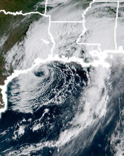


Rain associated with Tropical Storm Harvey has started to smack southeastern Louisiana, with heavy rainfall expected Tuesday as the storm continues its slow churn in the Gulf of Mexico
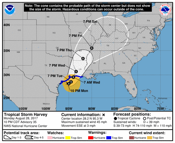
At 7 a.m. Tuesday, Harvey was moving toward the east-northeast at 3 mph with maximum sustained winds of 45 mph, according to the National Hurricane Center. Little change in strength is forecast during the next 48 hours.
The storm's motion should continue with a slow turn toward the northeast Tuesday. The NHC said Harvey's center is expected to be just offshore of the middle and upper coasts of Texas through Tuesday night before moving inland over the northwestern Gulf coast on Wednesday.

IMPACTS

The biggest threat to south Louisiana and remains flash flooding.
The National Weather Service placed south Louisiana in a moderate to high risk of excessive rainfall through Tuesday as rain bands from Harvey move across the area.
Rainfall amounts of 5-10 inches in southeast Louisiana, coastal Mississippi and Alabama are projected through the end of the week.
Locally, Baton Rouge is expected to receive 4-6 inches of rain; New Orleans is expecting 4-10 inches.
In southwest Louisiana, 10 to 15 inches of rain is expected over the next two days, in addition to the 8 inches that fell Monday, National Weather Service meteorologist Donald Jones said from the agency's Lake Charles Office.
But Jones warns of strong bands of rain, which will sporadically ride on the outskirts of Harvey, that could drop heavier downpours on different localities. Those high volumes of rain will continue to pose flash flooding — and more extensive flooding — risks for much of the state, especially in the southwest portion, Jones said. They also bring with them a threat of tornadoes, he said.
A flash flood watch remains in effect through 7 p.m. Thursday.
Can't see the video below? Click here.
RADAR
MORE INFORMATION

With Tropical Storm Harvey still making its slow and unpredictable crawl along the Texas coa…

As disaster strikes in Texas, several nonprofit and religious organizations in Baton Rouge h…

Three men from St. Tammany Parish had just arrived in Houston when they spotted an elderly w…

As Tropical Storm Harvey threatens south Louisiana and brings heavy rain and flood potential…

President Donald Trump is planning to travel to Louisiana this weekend to see the effects of…

The devastating flooding Hurricane Harvey is causing in Houston and southwest Louisiana is a…