


A stretch of the Ashley River in Charleston's Neck Area where a large development has long been planned could become a new spot for kayaking, boardwalk strolling and docking at a marina.
Those plans are detailed in a permit application filed by Highland Resources, the latest company working to clean up the once-industrialized site and build new homes and businesses there.
The Magnolia development was first announced in the early 2000s and has been supported by the city of Charleston. A 23-acre city park is already planned for near the proposed boardwalk, kayak dock and marina.
“The vision for the connection to the water originally came from Mayor Riley and then Mayor Tecklenburg," said David Bodenman, Highland's president and interim CEO.
The approved plans for the development require Magnolia to include a large city park with public access to the water.
“The city’s plan for Magnolia for at least 15 years has been to build a small city within our city and to have a large public promenade along the water," said Jacob Lindsey, director of Charleston's Department of Planning, Preservation and Sustainability.
"These will be public spaces," he said. “We’re looking forward to a major addition to the city’s park system."
One of the early steps is the permitting Highland Resources is pursuing from the Army Corps of Engineers and the S.C. Department of Health and Environmental Control.
The permit seeks approval to build a river overlook dubbed Heriot Overlook, a marsh boardwalk called Kings Grant Boardwalk, and a public pier identified as Landing Lane Pier. A marina known as Parker Heights Marina also needs approval. They would be located at the end of Braswell Street.
“These facilities are ways to enhance the access to the park," Bodenman said. “If you’re a day boater or a kayaker or want to catch a water taxi, or you just want to take your child and walk down a pier and fish or enjoy nature, it will be publicly accessible."

The Army Corps has initially determined the work would not adversely impact fish habitat.
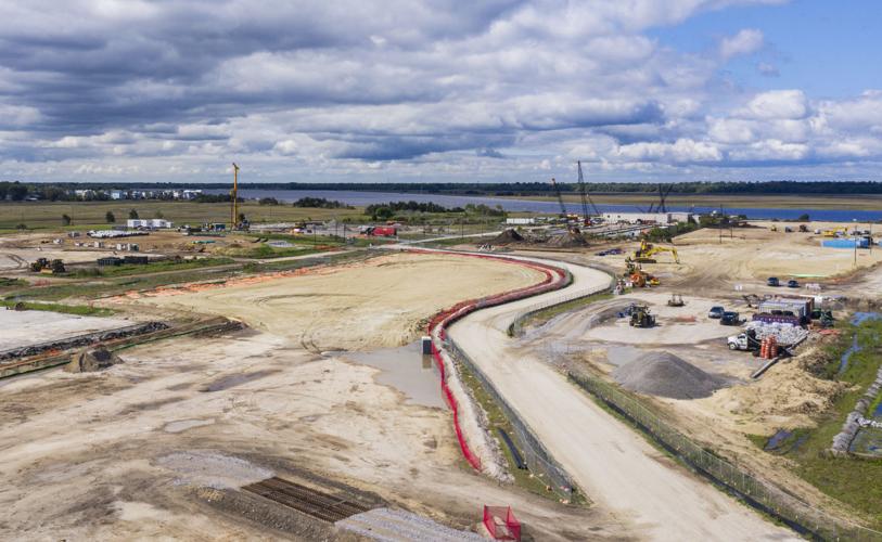
Right now the 200-acre Magnolia site, with 133 acres of high ground, is not much to look at. Located between Interstate 26 and the Ashley River, it's been the site of an extensive environmental cleanup operation that began nearly 20 years ago to deal with contamination left behind by fertilizer manufacturing and other industry.

The latest stages of that $77 million cleanup involve bringing in thousands of truckloads of dirt to provide a protective layer and raise the site by up to 3 feet.
At the same time, utility lines needed for the development are being installed, and roads are being prepared.
The development plans approved years ago by Charleston allow 3,500 residential units there, along with 1.27 million square feet of office and retail space and 690 hotel rooms.
The development approved by the city requires some housing to be affordable for people with moderate or low incomes.
Charleston's support for the project included construction of an $8 million bridge to the site, which earned the nickname "Bridge to Nowhere" after development stalled for years during the Great Recession.

“We are finally going to see public park spaces and waterfront spaces at Magnolia," Lindsey said.
Bodenman said the permitting process for the waterfront features have been in progress for a while. It could be two or three years before the facilities are under construction.

The city of Charleston built an $8 million bridge in 2010 to connect to the Magnolia development, but amid the recession the project stalled and ended in bankruptcy. The bridge appears on Google Maps as "Bridge to Nowhere." Lauren Petracca/Staff
“The work will more likely occur when we near completion on bringing roads and utilities to the waterfront," he said. "We’re working on all those things, but they aren’t done yet."
Bodenman said Highland Resources is using existing city parks on the water as models for their plans, including Waterfront Park, White Point Garden and Brittlebank Park.
Lindsey said the city will be involved in design review as plans move forward.


