
DENVER — High temperatures reached the upper 60s on Tuesday in Denver, only a few degrees from the record high of 72 degrees set in 1953.
The Front Range will stay dry Tuesday night with light snow showers developing in Colorado’s western mountains.
Snow intensity will pick up in the mountains Wednesday afternoon.
The heaviest snow accumulation will occur Wednesday across the Western Slope ski areas, including Steamboat Springs, Snowmass, Aspen, Crested Butte, Powderhorn, Monarch, Silverton, Purgatory and Wolf Creek.
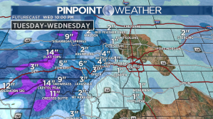
The central and eastern mountains will see lighter accumulations but will still accumulate a few inches.
Rain showers will move into the Front Range by Wednesday afternoon and will change over to a rain/snow mix and snow as temperatures get colder in the evening.
Most of metro Denver will not see any snow accumulation, but the south and west sides of the city could see small amounts less than an inch.
Snow showers will wrap up in the mountains, Front Range and eastern Plains by early Thursday morning.
High temperatures on Wednesday will drop to the low 50s and will fall quickly through the afternoon.
Temperatures will be in the 40s for the rest of the week and into the weekend with dry conditions expected.
Monday will bring another chance of snow showers to the Front Range.
 Pinpoint Weather Meteorologists Dave Fraser, Greg Dutra, Jessica Lebel, Matt Makens, and Chris Tomer.[/caption]
Pinpoint Weather has been independently certified as Colorado’s Most Accurate Forecast by WeatheRate.
We’re tracking weather today on FOX31 Denver and Channel 2 News — and when conditions are bad we send out the Weather Beast.


