The CLINT concept
CLINT is organised in a bottom-up structure with four macro components:
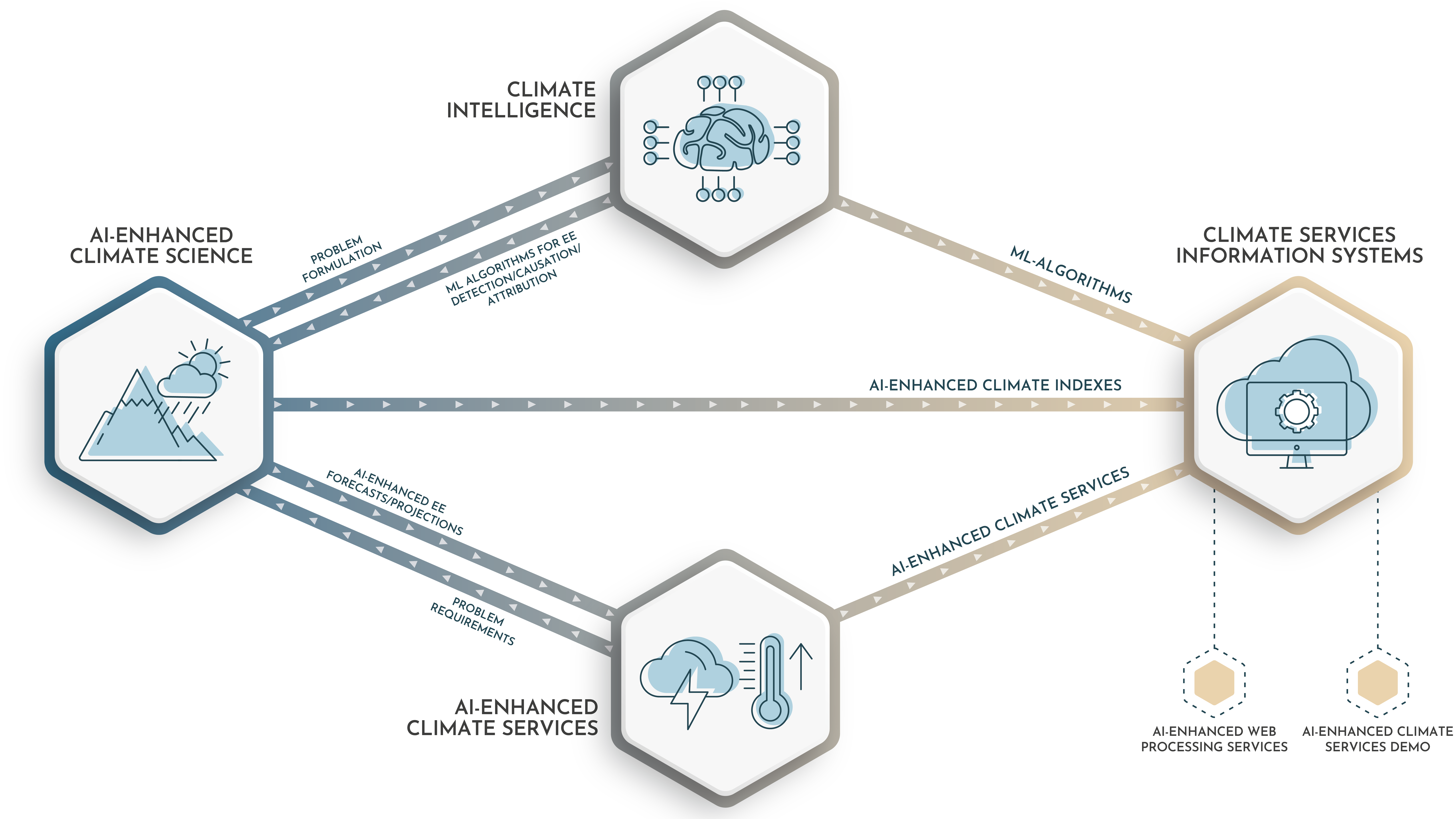
- Climate Intelligence, designing new Machine Learning algorithms to process big climatological data sets;
- AI-enhanced Climate Science, advancing the state-of-the-art on detection, causation, and attribution of extreme climate events.
- AI-enhanced Climate Services, to be developed at the EU continental scale across the water, energy, and food (WEF) Nexus and on selected climate change hotspots.
- Climate Services Information Systems to be deployed as web processing services based on advanced open software and data standards and as a commercial demo.
These four components are tightly interconnected. The Climate Science part of CLINT will be supported by innovative ML algorithms developed in the Climate Intelligence component. The benefit of using AI-enhanced Climate Science will be demonstrated by quantifying the value of the resulting AI-enhanced CS on the WEF Nexus at the continental scale in order to strengthen EU climate-related policies. Moreover, the input and applicability of the AI-enhanced CS on strengthening adaptive capacity will be assessed at the local scale in different Climate Change Hotspots covering a diversity of areas where climate change signals overlap with exposed and vulnerable communities. Lastly, CLINT will develop Climate Services Information Systems supporting both the access and the efficient processing of existing climate data according to the most advanced open software and data standards.
The extreme events
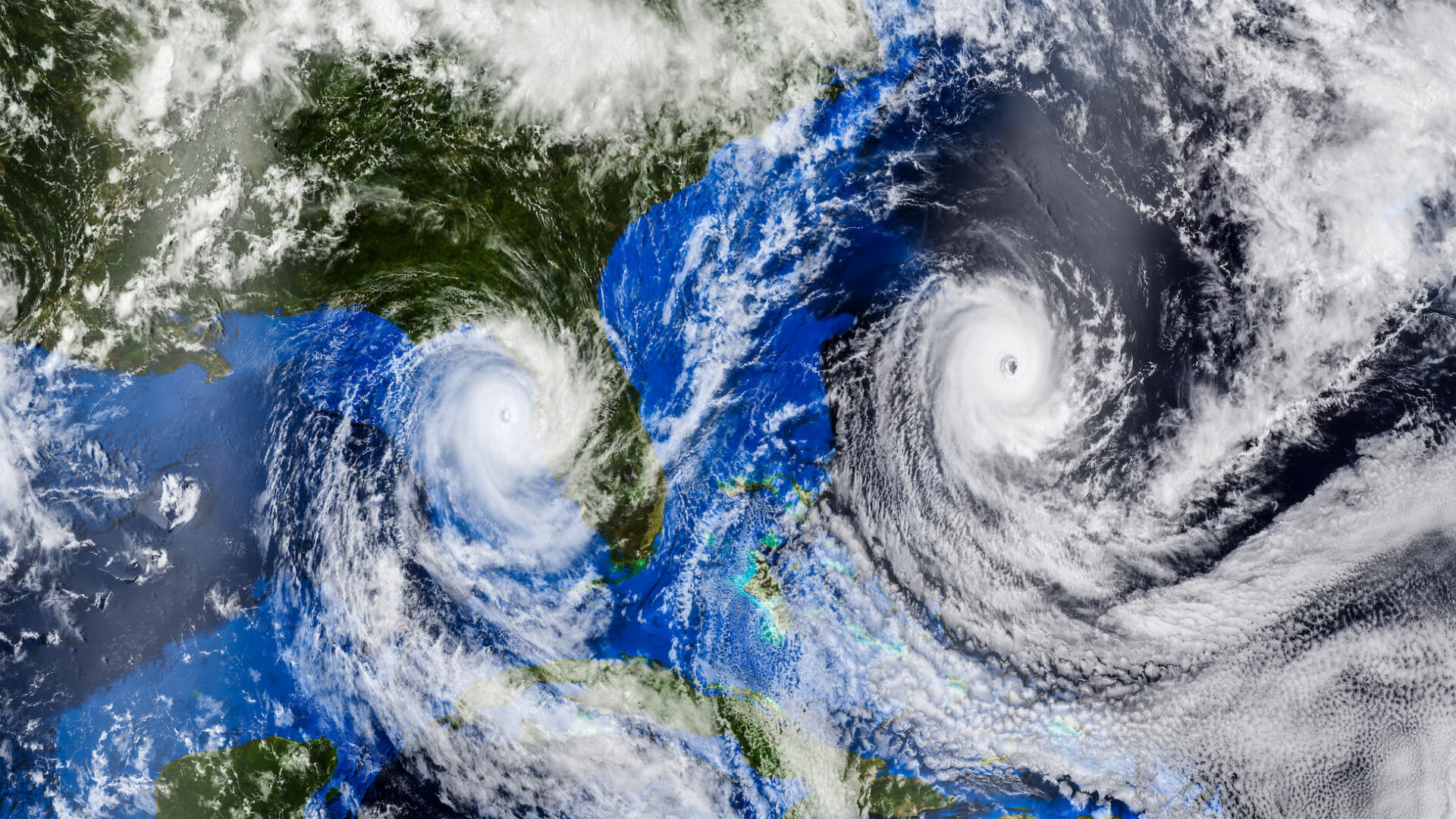
Although tropical cyclones develop along the tropical belt, their extratropical transition phase in the Atlantic basin is of great interest for European countries due to its role in determining extreme precipitation events over the western coast of Europe. Several European countries also have economic interests in areas traditionally affected by tropical cyclones (TCs). Different indices have been developed to estimate tropical cyclone activity based on large-scale atmospheric variables. However, while such indices well represent the annual cycle of TC count, they do not properly capture the interannual variability and long term tendencies of this metric. CLINT will:
- investigate the role of the different index components (i.e., atmospheric variables) for tropical cyclone counts, to support the ML-based formulation of new indices that better support tropical cyclone detections;
- enhance tropical cyclone predictions by using AI to identify key aspects of the 3-dimensional atmospheric structure preceding the genesis of tropical cyclones;
- assess the emergent European risks from extreme wind and precipitation and associated flooding from changes in extra-tropical transition of tropical cyclones induced by climate warming.
Heatwaves can severely impact ecosystems, human communities, and key socio-economic sectors. In agriculture and food production, very hot daytime temperatures can compromise yield even in presence of established irrigation plans, while recurrent episodes of elevated night temperatures (warm nights) may favour the proliferation of pests and the diffusion of diseases. Energy demand is also affected both during the day (when energy demand peaks) and at night (when, contrary to normal conditions, the demand does not drop significantly). The frequency of heatwaves and warm nights is projected to increase sharply even in a mitigated global warming scenario. Recent studies have focused on quantifying heatwave characteristics based on maximum daily temperature or daily mean temperature and warm nights based on minimum daily temperature. However, these indices do not take into account the spatial structure and time-evolving patterns of heatwaves, which are useful when assessing the affected areas and associated impacts. CLINT will:
- improve the understanding of what processes drive heatwaves and warm nights with a focus on subseasonal to seasonal time scales, by combining information from large-scale meteo-climatic fields as well as local land surface variables via ML algorithms.
- use the understanding of their multiple causal factors to generate improved subseasonal to seasonal forecasts of heatwaves and warm nights.
- contribute to developing AI-enhanced climate services that will better inform local adaptation strategies and policies within the WEF Nexus for future changes in heatwaves.
A drought, defined as a temporary but significant decrease in water availability, is a slowly developing natural phenomenon that can occur in all climatic zones. Although drought management has been extensively studied, traditional drought indices often yield imprecise information on detecting critical events and their associated impacts. This is due to the difficulty of capturing the complexity of extreme drought dynamics that evolve over diverse temporal and spatial scales, including short-term meteorological droughts, medium-term agricultural droughts, and long-term hydrological droughts, as well as the non-physical aspects related to droughts (water management, irrigation, etc.). Moreover, an increase in drought severity and frequency is expected from future climate projections. Although many regions over Europe are somewhat adapted to droughts, climate change projections estimate many of these regions will be taken beyond the breaking point. CLINT will:
- enhance the detection of extreme drought events by defining impact-based drought indices with ML algorithms that link the observed impacts of extreme droughts (e.g. reduction of electricity production or crop failures) with the candidate drivers of the event, including climatic, meteorological, and hydrological variables over different spatial and temporal scales, and
- focus on specific Climate Change Hotspots that are particularly vulnerable to water supply: semiarid regions, river deltas, and snow-dependent river basins.
Human and natural systems are often able to cope with a single extreme event, but they might be unable to sustain compound events (i.e., a combination of events, not necessarily extremes, that lead to significant impacts) and concurrent events (i.e., different types of events occurring within a specific temporal lag, as well as events of the same type in two different locations within a specific time period). Therefore, compound and concurrent events can expose humans and ecosystems to disproportionately increased risk compared to single extreme events. From a risk perspective, the primary concern relates to events with additive or even multiplicative effects. These effects can result from mutually reinforcing cycles between individual events, such as extreme droughts and heatwaves, linked through soil moisture and evaporation. Alternatively, they may develop through induced responses at distant areas of significant impact to the global system as in the case of concurrent hot extremes during summer 2018. CLINT will:
- prompt AI advances in the detection and characterization of the spatio-temporal evolution of compound events at the European scale and will explore global teleconnection mechanisms responsible for concurrent events, and
- bring improved understanding of concurrent events by uncovering key drivers and exploring their interaction and interdependence.
The CC hotspots
The selected climate change hotspots include semiarid regions (Southern Africa, Iberian Peninsula), river deltas (the Netherlands), and snow-dependent river basins (Italian Alps). These hotspots were selected because they are prone to severe impacts from EE under current and future climate conditions, and because they display a wide range of socio-economic development and adaptive challenges.
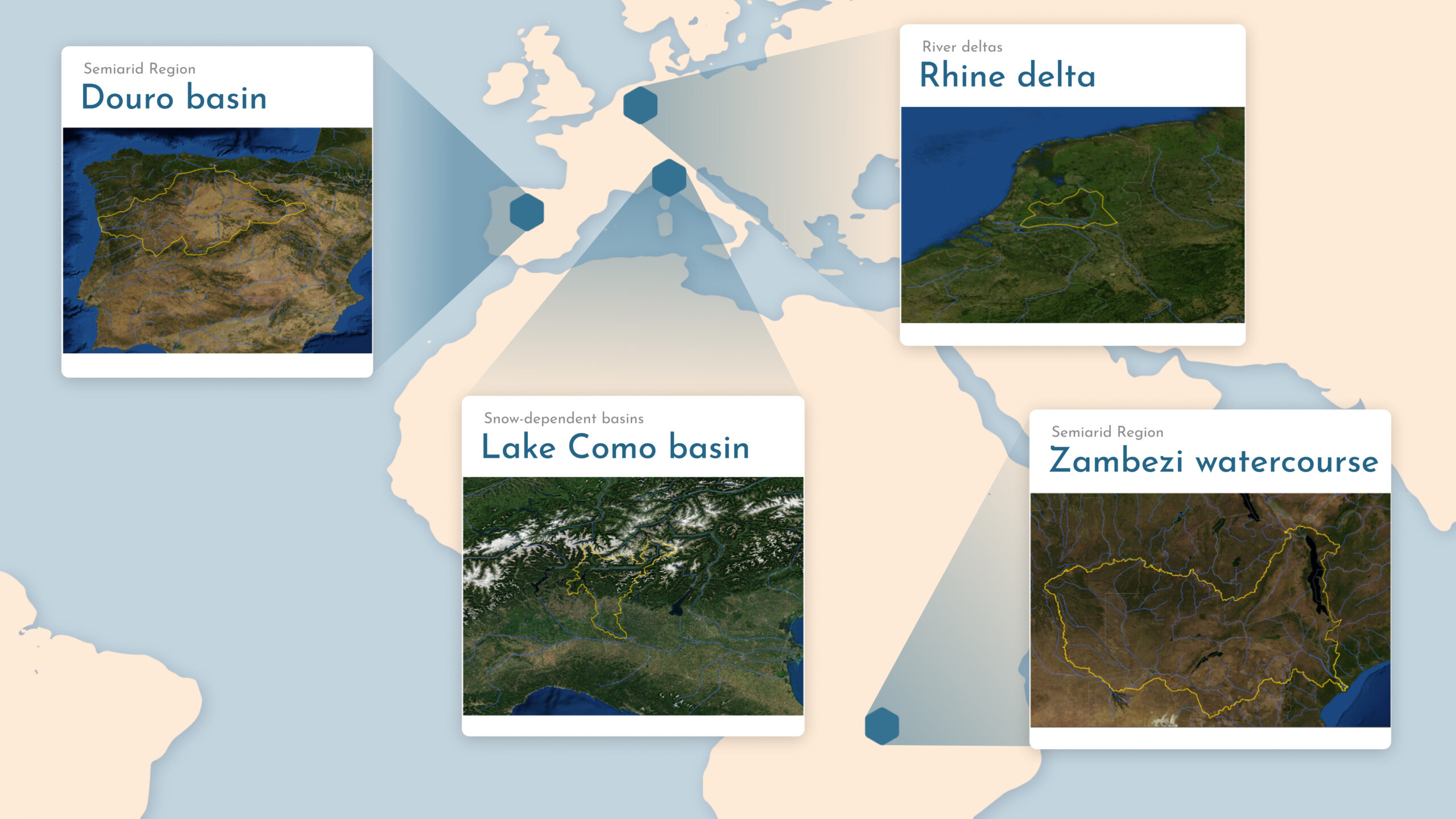
The Douro River Basin is the largest river basin in the Iberia Peninsula. It stretches over 98,000 km2 and is shared by Spain (80% of its territory) and Portugal (20%). The Spanish part of the basin (Douro River Basin District) is markedly rural and is scarcely populated. There are over 65 large dams that are used to satisfy the water demands in the basin, the hydropower of which corresponds to about 22% of Spain’s installed hydropower capacity. Droughts are one of the most recurrent and high-impact extreme events affecting the region, due to the uneven distribution of limited water resources and the strong dependence of irrigated crops and hydropower production. For example, the severe 2016/2017 drought affected the agricultural production of different crops in Spain, including tomatoes and wine grapes, and hydroelectric power production reached a historical minimum. CLINT will provide AI-enhanced seasonal-to-subseasonal hydroclimatic forecasts of extreme droughts for informing decisions about water allocation among users and the application of restrictions to established e-flows in case of extreme drought.
CLINT will consider two local water authorities in the Rhine Delta of the Netherlands, both susceptible to droughts: the Rijnland water board, which covers an area of about 1000 km2 in western Netherlands, and the Rijn en IJssel water board, which covers an area of 2000 km2 in eastern Netherlands. CLINT will provide AI-enhanced seasonal-to-subseasonal hydroclimatic forecasts of extreme droughts to support these two water authorities’ risk-based management of surface water allocation, alternative surface water supply routes, and groundwater abstraction. Drought adaptation strategies will also be studied using AI-enhanced climate projections for extreme droughts. Historically, however, the Netherlands have been fighting floods more often than droughts. In recent years, several cyclones landed on the European west-coast while being classified as tropical cyclones almost all the way up to landfall. It is not well understood how these storms are different from ones that do not make landfall in Europe, nor whether they will affect flood risk in the Netherlands. CLINT will provide climate projections for tropical cyclones and their extra-tropical transition towards the European coast to study implications for the Dutch rivers, lakes, and coast.
Located in the Italian Alps, the Lake Como basin is a highly controlled water system, including a large regulated lake serving a wide irrigation-fed cultivated area (1,320 km2). The hydro-meteorological regime is typical of sub-alpine regions, characterized by dry periods in winter and summer, and flow peaks in late spring and autumn fed by snowmelt and rainfall, respectively. The regulation of the lake is driven by two primary competing objectives: water supply, mainly for irrigation, and flood control along the lake shores. The agricultural districts downstream prefer to store snowmelt in the lake to satisfy the peak summer water demands, when the natural inflow is insufficient to meet irrigation requirements. Yet, storing such water increases the lake level and, consequently, the flood risk. Additional interests are related to navigation, fishing, tourism, and ecosystems, that further challenge the existing water management strategies and motivate the search for more efficient solutions relying on hydroclimatic services. CLINT will provide AI-enhanced seasonal-to-subseasonal hydroclimatic forecasts of extreme droughts indices for informing the operation of the lake that will contribute to improve the reliability of the irrigation supply, particularly in facing severe dry conditions, as well as to mitigate existing conflicts between competing sectors. CLINT will also generate AI-enhanced seasonal-to-subseasonal forecasts of heatwaves and warm nights, including compound events, to inform agricultural practices.
The Zambezi river basin is the fourth largest basin in Africa, with an area of 1.32 million km2 shared by eight countries (Angola, Botswana, Malawi, Mozambique, Namibia, Tanzania, Zambia, and Zimbabwe) and populated by almost 40 million inhabitants. The high runoff in the upper part of the basin combined with a fall of more than 1000 m during its course to the ocean provide a good opportunity for hydropower production. Existing irrigated areas cover about 182,000 ha; major cultivated crops are sugar cane, rice, wheat, and maize. CLINT will provide AI-enhanced seasonal-to-subseasonal hydroclimatic forecasts of extreme droughts for informing the multipurpose operation of the system (i.e. dams and irrigation diversions) that will contribute to improving the system performance in terms of hydropower production and irrigation supply, as well as to mitigating existing conflicts between these competing sectors. In addition, CLINT will generate an AI-enhanced warning system for tropical cyclones to improve flood preparedness in Mozambique, a region exposed to tropical cyclone impacts as demonstrated by the recent experience of the Cyclone Ida in 2019, which resulted in an estimated 1.85 million people in need of humanitarian assistance and protection.