With one of the strongest El Niños on record, and given last winter's cold, snowy East and generally warm, dry West, we've assembled the five biggest questions about the upcoming winter in the U.S.
We'll do our best to provide some insight on each. However, note that long-range forecasts have inherent uncertainty, no two El Niños, even strong El Niños, are alike, and there are other factors at play that could, at times, mask or overwhelm El Niño's influence on the weather pattern this winter.
1) Will the Western Drought Finally Be Quenched?
As of early December, a large swath of the West, including California, the Great Basin, interior Northwest and parts of the northern Rockies were in drought.
In California, the multi-year drought has been exceptional, with reservoirs receiving little, if any, recharge from the paltry Sierra snowpack last winter and spring. This followed the driest year on record for the Golden State in 2013.
(MORE: Folsom Lake Reaches Record Low)

Snowpack in the Cascades and parts of the Rockies was also paltry last winter and spring,
Four of five previous strong El Niño winters were wetter than average (as classified by Jan Null, a consulting meteorologist based in the San Francisco Bay Area) in California. However, the anomalies were mixed in the Pacific Northwest and Cascades.
When examining each month individually during strong El Niños (see the bottom of this article from late November), California's precipitation typically picks up in January, continuing into March, while the Pacific Northwest tends to dry out later in the winter.
So, there is hope the subtropical or southern-branch jet stream, typically turbo-charged during strong El Niños, will deliver long-awaited relief for at least some in the West.
However, it's worth noting winter was relatively dry during the 1965-66 strong El Niño in California. In addition, heavy rainfall can occur with or without El Niño present and that was the case in the winter preceding the strong 1997-1998 El Niño.
2) Will New England Get a Break This Winter?


We understand if "snow" is a four-letter word not allowed to be spoken for those still with memories of a record-setting snowy 2014-2015 season in parts of New England.
And that came along with stubborn, persistent cold that gripped much of the Northeast.
The past two strong El Niños have been much warmer than average in New England. However, the three previous strong El Niños were near or colder than typical.
This is a clear example of other factors in play. In New England's winter, one of the most prominent factors is the presence or absence of blocking high pressure aloft in the North Atlantic Ocean near Greenland, referred to as the North Atlantic Oscillation.
When present, the high pressure over or near Greenland blocks the jet stream from flowing west to east, allowing it to plunge south in the eastern U.S., bringing ample cold air with it.
Predicting this in any winter is difficult. However, in the late-November winter outlook, WSI, a division of The Weather Company, noted "the only winters that have had big North Atlantic blocking since 1970 were within two years of a solar minimum" and the next solar minimum isn't expected for approximately five years.
Furthermore, as we noted in our El Niño seasonal snowfall piece, it is the degree of North Atlantic Ocean blocking that seems to play a strong role on whether a strong El Niño's season either brings very little snow (little blocking) or brings near- or above-average snowfall, not only in New England but also farther south in the Mid-Atlantic states.
It isn't just about snow, however.
One of the most destructive ice storms in history hammered New England and eastern Canada in early January 1998, during the strongest El Niño on record.
While temperatures in most of New England were generally "warmer than average" for early January, just enough cold air was held in place, topped by an impressive tap of moisture from the Gulf of Mexico.
This is further proof that a potential "warmer" winter doesn't necessarily preclude significant winter storms, including ice storms.
3) Is the Midwest Winter a Dud?
We've already seen one of the heaviest November snowstorms of record (Winter Storm Bella), followed by a central Plains ice storm (Winter Storm Cara), then another blanket of snow (Winter Storm Delphi), some of which were also hit by Bella.
Yet winter could end up being a dud in the nation's heartland.
So far, December kicked off with a massive warm-up, setting records as far north as northern Manitoba, including the Nation's Icebox, International Falls, Minnesota.
(MORE: What a Warmer December Means)
The two strongest El Niños on record prior to this winter, 1997-98 and 1982-83, both were much warmer than average over the entire Midwest and Plains states.
However, two other previous strong El Niños, 1972-73 and 1965-66 were quite cold, especially in the Plains, and 1957-58 was cold in the Great Lakes and Ohio Valleys, but warm in the northern Plains.
So, confidence is highest for a warm winter in the northern Plains and Upper Midwest.
But does that necessarily mean less snow?
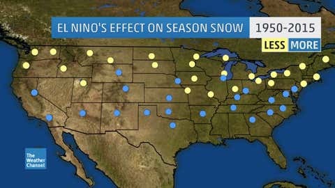
In general, strong El Niños tend to actually enhance season snow in parts of the central Plains, particularly if North Atlantic blocking isn't dominant.
(MORE: El Niño & Seasonal Snow)
Remember, it can still be warmer than average, but if average is only, say, the low to mid 20s, that could still be warm enough for snow to pile up.
Conversely, a swath from the Great Lakes into the Upper Midwest and Northern Plains sees a marked reduction in snow in strong El Niño seasons.
4) A Bigger Southern Snow and Ice Threat?


We've seen several instances the past few winters of what would seem to be relatively little wintry precipitation by northern standards bringing major southern cities to a halt.
(FLASHBACK: Atlanta's Gridlock)
So, given the southern branch jet stream's dominance, it's worth exploring if this puts the South at a greater risk of snow or ice storms this winter.
Examining January and February, the two months in which snow or ice in the South is generally at its highest probability, the five strongest El Niños were near or wetter than average from Texas to the Carolinas, but also colder than average in that same swath.
While the precipitation and temperature regimes may be intertwined (precipitation keeps temperatures cool), taken at face value, this would suggest a higher risk of snow and ice storms.
But some (not all) strong El Niño winters -- such as the last two events in 1997-98 and 1982-83 -- can be much warmer and less snowy than average over the northern tier of states.
If 2015-2016 follows these previous two events, this would suggest the cold air making it into the South may not be as refrigerated, given either less cold air and/or less snowpack to the north to help keep the air cold. As many in the South well know, it's a fine line between 29 degrees and an ice storm or 33 degrees and a cold rain.
Air that may be "warmer than average" in the northern states only has to be "cold enough" for snow or ice in the South. Furthermore, if the North Atlantic blocking we mentioned earlier is a bit stronger at the right time, colder air would pour into the South to intercept that active subtropical jet stream and voilà, a snow or ice storm.
So, despite all the talk of relative warmth possible elsewhere this winter, keep an eye out for at least one, if not more, southern snow or ice events.
5) A "Severe" Sunshine State?

With a farther south storm track and stronger subtropical jet stream, could Florida see more severe weather than usual?
The National Weather Service in Tallahassee, Florida, examined tornado counts from 1950-2009 in El Niño, La Niña and neutral seasons. They also parsed out El Niño seasons by strength.
They found a pronounced uptick in tornadoes during strong El Niño seasons in central and south Florida from November through April, with more than double the tornadoes of La Niña, neutral and even weak or moderate El Niño seasons.
Instead of mainly non-severe bands of rain or thunderstorms immediately ahead of cold fronts in other winters and springs, wind shear more favorable for supercell thunderstorms and tornadoes would be higher during a strong El Niño in central and south Florida.
No such correlation was found by NWS in north Florida, southern Alabama or south Georgia, however, as severe outbreaks can occur in those locations any winter or spring, regardless of El Niño or its intensity.
Florida’s deadliest tornado outbreak happened in February 1998, during the strongest El Niño of record.
Seven tornadoes struck central Florida late at night on February 22, three of which were rated F3. Twenty-four were killed in Kissimmee and a total of 42 lives were lost in the outbreak.
This is not to say that one or more such outbreaks will occur in this strong El Niño winter or spring, but rather that the chances are higher.
Unfortunately for vacationers and residents alike, what is more certain is a wetter “dry season” in the Sunshine State.
The majority of strong El Niños in the past have been wetter than average over much of Florida from December through March.
As of this writing, Miami has already chalked up one of its record wettest Decembers, and the wettest since 1905. This month is already wetter than the 9.02 inches received in August 2015, a month that lies in the heart of Florida's wet season.
The Southeast River Forecast Center, in the NWS-Tallahassee study, also found river flood events in the Sunshine State from 1975 to 2006 to be over four times as numerous during strong El Niños as during neutral seasons.
MORE ON WEATHER.COM: Snowflakes Closeup (PHOTOS)