As the I/ITSEC 2021 conference nears, both Esri and Presagis are collaborating on a demonstration showcasing route analysis through simulation. Each company’s domain expertise and technology create a unique opportunity to solve complex problems in digital twin generation for military training, scenario analysis, and asset tracking.
Esri’s geospatial technology and the ArcGIS ecosystem provide the foundation for mapping, generating accurate data, and projecting real-world coordinate space. In addition, Presagis provides simulation toolkits for real-time interactive location intelligence solutions through STAGE, a widely adopted commercial off-the-shelf Computer-Generated Forces (CGF) solution.
It’s an exciting time, and we’re ready to help developers forge new technology through the convergence of GIS and simulation. This article will provide you with context for the need, the use of technologies for defense simulation, the tools being provided by Esri and Presagis, and a summary of the demonstration being presented at I/ITSEC.
A Need for Accurate Digital Environments
Seeing a growing need in the defense space to rapidly deploy a digital twin to analysts and field operators, both Esri and Presagis have embarked on a mission to find solutions that will provide a realistic and accurate representation of our world. One that rapidly converges numerous streams of different – and sometimes unstructured – data into one cohesive environment that can be analyzed.
The use of GIS provides a canvas for spatial context that can include terrain tiles, I3S or photogrammetry, and authoritative features rich with metadata. Combining authoritative data and mesh contextually onto a GIS canvas provides scope and context for complex environments that need spatial recognition. And since real-world training requires real-world accuracy, an accurate geospatial context is required to build simulators in the defense space.
Scope and context of real-world data forged by GIS analysts provide developers the power to build digital twins, stakeholders the visuals to support complex planning, and field operators the logistics to execute operations.
Scenarios requiring GIS workflows can include the determination of safe passage through a valley by using Line of Sight, predetermining vantage points through Viewsheds, and laying the foundation for realistic cities with transportation networks and utility systems.
This ultimately means developers can build authoritative systems on top of a GIS foundation in their projects. This GIS foundation provided by Esri fuels the spatial context for simulation to run analysis and game engines to visualize the data.
This convergence of GIS and game engines is happening now with the ArcGIS Maps SDK for game engines.
ArcGIS Maps SDK for game engines
Historically, importing GIS terrain and data into a game engine has been a complicated process. The GIS ecosystem is complex and requires expertise in its formats, terminology, and tools. The ArcGIS Maps SDK plugin is going to alleviate the lift for developers to converge authoritative GIS into simulators built with game engines.
This means bringing in tiles and features, from terrain to photogrammetry, will be easier. Developers will be able to either use the plugin interface in Unreal Engine or Unity, or they’ll be able to generate custom solutions with the SDK through code.
The plugin’s UI will enable users on all fronts, both non-developers, and developers, to incorporate the Esri GIS ecosystem into their projects. And the SDK will provide extensive power to developers to code custom solutions utilizing GIS data.
Highlights
- First, there are two products, ArcGIS Maps SDK for Unity and ArcGIS Maps SDK for Unreal Engine.
- Both are available as plugins to provide direct access to ArcGIS services and data.
- Both local and global experiences are available.
- Geospatial data support
- Scene layers from 3D object and integrated mesh, based on the I3S specification
- Raster tile layers such as basemaps with imagery
- Elevation layers to represent terrain
Read more about features for the ArcGIS Maps SDK here

Convergence of GIS, Simulation, & Game Engines
GIS, Simulation, and Game Engines provide value to both developers and projects by enabling rapid visualization, accurate geospatial context, and analysis.
As we discussed above, the ArcGIS Maps SDK streamlines the process to import Esri GIS data into the game engine. Compiling game engine projects with GIS streams of both static and live data is powerful, and it will light up synthetic environments with real-world assets and terrain in your simulator.
This convergence is powerful, and it means projects utilizing GIS can be visualized in the game engine and ultimately experienced with a desktop, XR, mobile, or the web. This device’s flexibility brings the experience from the operations room to the field.
These experiences can include deployment of various 3D environments to the field for operators to train on, tabletop display for scenario planning or logistics, and analysis of real-world locations using simulation.
Esri and Presagis have been working together to develop GIS and simulation solutions, in fact, we’ll be demonstrating one of these solutions at our booth at I/ITSEC 2021 discussed in the section below.
ArcGIS Maps SDK & Presagis STAGE Demo
With the visualization capabilities of the ArcGIS Maps SDK powered by Unreal Engine and intelligent real-time traffic simulation from Presagis STAGE, the user can drive analysis of traffic and transportation assets to determine the fastest route to a target location. The simulation and visualization are live and real-time, allowing users to view each vehicle in 3D. With live simulation, user interaction can modify traffic conditions while the simulation is running.
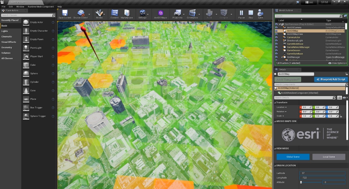
More specifically, this demo shows how exploratory analysis can be used to visualize changes to traffic patterns during the simulation by isolating various sectors of the city into cubic chunks (ie. extruded cells). These cubic chunks are rendered with various intensities of color to display average traffic density and extruded to show average traffic speed in an area. Furthermore, the “hero” asset, shown as an emergency response vehicle, moves toward the target location based on variables presented by the street system and defined by traffic conditions. All of this information can be used to visually assess and better understand the impact of traffic variables, barriers, and behavior on the movement of a specific asset through a real-world environment.
Get Started
To learn more about Esri ArcGIS Maps SDK or Presagis STAGE, and view the demonstration, stop by either the Esri or Presagis booth at ITSEC.
And lastly, we invite you to use the following link to join the ArcGIS Maps SDK for game engines beta program: http://esriurl.com/a4ge


Article Discussion: