When I was around 8 or 9, on a family vacation with two of my cousins. We visited Cedar Breaks and Bryce Canyon. Both amazing parks and great memories. With winter here Cedar Breaks is to cold to visit but… “I am dreaming of warm camping, just like the ones I use to know. Where the treetops glisten and children listen to hear the birds tweet…”
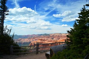
Located close to I-15 near Cedar City, Cedar Breaks National Monument contains a steep, bowl-shaped cliff face eroded into the west side of the Markagunt Plateau, similar to Bryce Canyon National Park (though much less visited), with colorful strata and many strange rock shapes. The Southern Paiute called Cedar Brakes translates to “the place where the rocks are sliding down all the time.”
Cedar Breaks National Monument is excited to have the designation of Cedar Breaks as an International Dark Sky Park. This distinction recognizes Cedar Breaks as a sanctuary of natural darkness and for the opportunity to provide visitors the enjoyment of the night sky. Far from any metro light pollution and high in altitude makes sleeping under the stars a night to remember.
—- Location —-
Cedar Breaks National Monument can be reached from four directions. In the north, UT 143 climbs quite steeply from Parowan on I-15, passing the Brian Head ski resort and into the northern part of the national monument, then turning away west, through more hilly woodland to Panguitch near Red Canyon. The other road is UT 14, approaching from Cedar City up a steep canyon – it ascends 4,000 feet in 18 miles, and once past the turning to Cedar Breaks continues to US 89 at Long Valley Junction. The nearest city with regular airline service is Las Vegas, Nevada. To get to Cedar Breaks National Monument from Las Vegas, follow I-15 north till you get to exit 57 and follow UT-130 to UT-14 in Cedar City, Utah. Follow UT-14 to UT-148 and follow UT-148 into the National Monument. UT-148 will remain open until snow forces its closure. Until that time regular traffic is permitted, but caution is advised in winter conditions.
—- Park Camping —-
Camp at 10,000 feet elevation! Camping is available approximately from mid-June to mid-September. Each site has a picnic table and fire pit or grill. There are also restrooms with showers, chopped firewood, and water spigots. Note that the campground opening and closing dates may be slightly earlier or later and is subject to favorable weather. Point Supreme Campground has 25 campsites and accommodates both tents and RVs. There is not a dump station located within the campground. Nearby dump stations are located at Duck Creek on Highway 14, and a free dump station at Panguitch on Highway 143, and KOA, in Cedar City. The nearest local store is located in Brian Head (eight miles north of the campground). Brian Head also has WiFi access, several small restaurants, and a gas pump (credit card only). Duck Creek (ten miles south-east of the campground) and Panguitch (33 miles from the campground) have gas.
—- Free Camping —-
Based on https://freecampsites.net/#!cedar%20breaks%20utah there are 15 free campsites within 20 miles of Cedar Breaks National Monument.
—- Area Camping —-
http://www.rvparkreviews.com/regions/utah/cedar-city/point-supreme-campground-nps
https://www.hipcamp.com/discover/utah/cedar-breaks
https://www.campendium.com/point-supreme-campground
https://koa.com/campgrounds/cedar-city/local-area/attractions/
https://www.allstays.com/Campgrounds-details/31104.htm
http://www.motorhome.com/motorhome-travel/national-parks/cedar-city-utah
—- Hiking & Biking —-
Within the national monument, there are several hiking trails. Sunset trail is an easy two-mile round trip paved trail. This path is great for children, the elderly and those using mobility devices. Spectra Point/Ramparts Overlook trail, at 10,500 feet, is rated as a moderately strenuous trail. The spectra Point Overlook trip is only two miles round-trip whereas the Ramparts Overlook hike is four-miles round-trip. In contrast, the Alpine Ponds Trail has no major viewpoints of the formations but instead encounters trees, meadows, flowers, and wildlife en route to a tranquil pool fed by melting snow and is an easy two mile loop. Just beyond the north edge of the monument, a longer trail (Rattlesnake Creek) drops 2,500 feet in four miles through forests of fir, spruce, and aspen into the Ashdown Gorge Wilderness. Hikers should be well versed in reading a map as trail markers are sometimes poor or non-existent on the Rattlesnake Creek Trail.
https://www.nps.gov/cebr/planyourvisit/hiking.htm
https://www.hikingproject.com/directory/8012827/cedar-breaks-national-monument
https://www.alltrails.com/parks/us/utah/cedar-breaks-national-monument
http://www.utahmountainbiking.com/idx-main.htm
https://www.mtbproject.com/directory/8010491/utah
http://www.discovermoab.com/biking.htm
—- Things to do —-
Utah’s Patchwork Parkway National Scenic Byway (S.R. 143), Markagunt High Plateau Scenic Byway (S.R. 14) and Cedar Breaks Scenic Byway (S.R. 148):
This high-elevation and densely forested area of Southern Utah offers a particularly unique leaf peeping experience this fall. During June and July, a fire consumed 70,000 acres near the area of Brian Head, though the town and resort were fortunately saved. In many ways, the patches of charred backdrop make the contrast of the multitude of spared trees even more dramatic. Yes, you will see fire damage along Utah’s Patchwork Parkway National Scenic Byway, but you will also see maples and aspens, golden and fiery red, rising triumphantly — almost a tribute to their fallen soldiers — along with your journey up to a 10,000-foot plateau. Remarkably, this area connects three scenic byways and features the outstanding Cedar Breaks National Monument — the topmost rise of the geological Grand Staircase. You can also experience the sparkling white beauty of winter at Cedar Breaks! There are many activities available for those who are unafraid of a little cold weather! Once the first heavy snowfall closes Utah Highway 148 (roughly mid-November to late May) it becomes a groomed trail through the monument for visitors to ski, snowshoe and snowmobile. For more info on accessing the park in winter, visit our Winter Access page.
https://www.nps.gov/cebr/planyourvisit/winter-access.htm
http://www.utah.com/snowmobile/cedar_mtn.htm
https://www.visitcedarcity.com/cedar-breaks-national-monument/
https://arsl.info/activities-attractions-in-southern-utah/
http://www.bwpbrianheadhotel.com/Attractions-Brian-Head-Utah.php
—- References —-
https://en.wikipedia.org/wiki/Cedar_Breaks_National_Monument
https://www.nps.gov/cebr/index.htm
https://www.visitutah.com/places-to-go/state-andsouthern/cedar-breaks
https://www.nationalparks.org/explore-parks/cedar-breaks-national-monument
https://www.nationalparkstraveler.org/2017/07/short-introduction-cedar-breaks-national-monument


