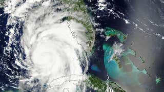
Despite Tropical Storm Erika's demise on Saturday morning, its remnant moisture is still bringing locally heavy rain to the Southeast U.S., including Florida, through early this week. Also playing a role in the threat for locally heavy rain in the Southeast is a southward dip in the jet stream over the region that is helping to transport moisture northward.
(RECAP: Tropical Storm Erika)


It is difficult to pinpoint exactly which locations will see the heaviest rainfall, but a general swath from the Florida peninsula to the eastern Carolinas may see heavy rainfall at times into early Tuesday.
While this sounds like welcome news to parts of South Florida and the Deep South currently in drought, rain rates of several inches per hour in the heaviest rain clusters could quickly trigger flash flooding.
Slow-moving thunderstorms along the South Carolina coast on Monday morning resulted in flash flooding near the Charleston area. Water rescues and road closures were reported in the area and some homes and businesses had water entering them. The Charleston airport had seen 6.43 inches of rain on Monday through 10:00 a.m. EDT, making it the second wettest August day on record there. It's also the fifth wettest day of any month on record, there.
(MORE: Flooding Reported Near Charleston)
Parts of central Florida, particularly around the Tampa/St. Pete metro area, were soaked with heavy rain in recent weeks. Therefore, any clusters of heavy rain, there, would quickly trigger flash flooding and worsen existing river flooding.
In addition to the threat for heavy rainfall, a moderate risk of life-threatening rip currents continues from the east coast of Florida to North Carolina.
About 5 inches of rain was measured in southeast Florida near Cooper City and Weston in the 24 hours ending 11 a.m. EDT Sunday and near St. Augustine, Florida, 4.3 inches of rain was reported on Sunday. Farther south, Miami recorded just under 3 inches of rain over the weekend. In addition, a thunderstorm wind gust of 51 mph was reported northwest of Key West at Smith Shoal Light.
(MORE: Could Erika Quench Three Droughts?)
Street flooding was also reported due to the heavy rainfall in Gainesville, Florida as well as near St. Augustine on Sunday evening.
Erika's Flooding History
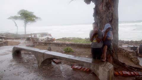
Intense rainfall impacted the Dominican Republic on Friday, with a personal weather station in Barahona reporting over 24 inches of rain. That station also reported an astonishing 8.80 inches of rain in one hour from 8 p.m. to 9 p.m. Friday.
A band of torrential rain also resulted in deadly flash flooding on the island of Dominica in the Lesser Antilles, Thursday. Roads were washed out, homes were damaged and an airport flooded.
(MORE: Flooding Hits Dominica)
Canefield Airport near the capital of Roseau, Dominica, picked up 12.64 inches (322.4 millimeters) of rain in a 12-hour period ending just before 2 p.m. EDT Thursday.
Bands of locally heavy rain currently over Haiti will shift to parts of Cuba, Jamaica and the possibly the Bahamas by late-day Saturday.
Historically, some of the highest death tolls with Caribbean tropical cyclones have occurred in these situations.
The National Weather Service in San Juan, Puerto Rico, said some parts of the island had already picked up 3 to 4.5 inches of rainfall in Erika's rainbands as of early Friday morning.
MORE ON WEATHER.COM: Tropical Storm Erika (PHOTOS)