When the Northwest Arkansas Regional Planning Commission developed the new Razorback Regional Greenway, it created more than a network of shared-use trails for area cyclists, runners and walkers from Fayetteville to Bella Vista. The greenway is also a tourist attraction.

For instance, some friends and I were attracted. After the greenway's grand opening May 2, I read about the 36-mile route in the Arkansas Democrat-Gazette, watched a video by Northwest Arkansas Democrat-Gazette photographer David Gottschalk (on.fb.me/1MSy9Zg), and thought, "This sounds like a great destination for my next cycling adventure."
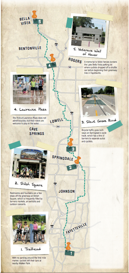
And so June 11, after dropping off a return shuttle vehicle at Bella Vista, our little group of cycling friends met at Walker Park on 15th Street in Fayetteville, prepared to ride the greenway.
Cyclists can begin their trek at the northern or southern terminus of the Razorback Regional Greenway, or any point in between, but I'm one of those people who believes you haven't officially ridden the entire route unless you begin at the marker labeled 0 (zero). That is not at Walker Park. The trail passes Walker Park, but the official first milepost is 0.55 mile south.
As there's no parking at the first milepost, our group left vehicles at Walker Park and pedaled 0.55 mile south for a photo op at the "official" trailhead.
Standing at the marker, I noticed another path stretching away to the west and was curious where it might lead. Matt Mihalevich, trails coordinator for the city of Fayetteville, tells me that this is the Town Branch Trail, which also begins at the greenway's Mile 0. Currently this city path travels west 0.8 mile to Greathouse Park.
Mihalevich said the city's shared-use trail-building crew is working on extending Town Branch Trail west to Razorback Road. Later it will continue farther west and then north toward Interstate 49 and Martin Luther King Jr. Boulevard. Yet another trail in the works, to be called Cato Springs Trail, will extend from Greathouse Park south to connect with the new regional park.
Backtracking on the greenway from Mile 0 to 15th Street, we found that the bicycle/pedestrian traffic lights for the crossing at 15th were installed but are not yet functioning. We crossed with caution.
The 12-foot-wide paved trail borders the lush green lawns of Walker Park, the second park added to the city parks system, in 1949.
TUNNELING
Soon we were passing through a tunnel (about 100 feet long) under Martin Luther King Jr. Boulevard, the first of many tunnels designed to provide cyclists safe crossings when the trail intersects major highways.
Everything looks different when touring a city on a bike trail. I have visited Fayetteville often over the past 40 years, but this time I saw a different place.
As you pedal past the sign for a spur trail to the Fayetteville Public Library, you are riding the Frisco Trail. Mihalevich told me this is the oldest existing section of trail utilized by the Razorback Regional Greenway network, and it was completed in 2005.
Next the Razorback Regional Greenway routes you past the Walton Arts Center and through downtown Fayetteville.
Our touring group paused after crossing Dickson Street for a photo in front of the historic Frisco Railroad Depot, which now houses a Chipotle Mexican Grill. Only 3 miles into our ride, it was too early for a pit stop at any of the many restaurants in the area. As I pedaled onward, I peered mournfully across the street at the Hog Haus Brewing Co.
Walkers, runners and other cyclists appeared well-educated in the proper trail etiquette of staying right and always announcing passing on their left. Even in heavily congested areas, other trail users we encountered were courteous and friendly.
After exiting downtown Fayetteville, the Razorback Regional Greenway routes cyclists along creeks and through flowering woodsy areas. I rode past thistles more than 6 feet tall and fields of delicate Queen Anne's lace in full bloom.
As the Arkansas summer heat continued to mount, everyone enjoyed the lengthy, cool tunnels that passed under I-49 -- especially the 650-foot tunnel under Fulbright Expressway, the longest pedestrian tunnel in the state. The shade from the trees that border much of the Razorback Regional Greenway also was greatly appreciated.
SIGNS OF CHANGE
Cyclists will notice a number of different names of the trail signs along the greenway. Many of these names, such as Frisco Trail and Scull Creek Trail, denote in-town commuter links created by cities and later linked to make the greenway.
Just continue to watch for the "Northwest Arkansas Razorback Greenway" signs, and you will have no problem following the route. Of course, the official name of the trail network is now Razorback Regional Greenway, so those signs could change.
As a backup, I recommend using the smartphone-friendly trail map at nwatrails.org. Select the Razorback Regional Greenway trail from the drop-down menu, and then scroll to the interactive map. The map includes icons for various points of interest along the route.
Currently the map is accessed using the browser on a smartphone. However, Misty Murphy, regional trail coordinator for the Northwest Arkansas Council, says an application is being developed that would show where a user is on the route, provide easy directions and highlight more trailside attractions.
Murphy predicts the app will be available by summer's end.
HANDY FACILITIES
The Razorback Regional Greenway passes the picturesque shores of Lake Fayetteville and Springdale Lake. At Lake Fayetteville, the bridge crosses at the spillway, providing a great place to pause and enjoy the waterfall.
If you are in need of a bicycle repair, the Lewis & Clark Oufitters bike shop is a short pedal to your left after crossing the dam.
In downtown Springdale, the greenway passes through Shiloh Square. The plaza includes an open air space for activities such as farmers market, art exhibits, outdoor concerts and other events open to the public.
The area also includes clean public restrooms and a water fountain. Water and restrooms also are available in many of the parks the trail passes, but the Shiloh Square facilities are conveniently located beside the trail.
As you leave downtown Springdale, the greenway passes the lush Magnolia Gardens and a historical marker about the area's Civil War involvement.
While riding along the pathway on Silent Grove Road, you get to experience a first for the state, a cycle track.
As Murphy explained it, "They put the street on a diet."
This is a process where they take an existing street and, either by eliminating a center turn lane or reducing wide shoulders, create an adjoining two-way bike path, with a barrier for protection between the cyclists and the automobile traffic.
At Mile 26, we had a bit of trouble figuring out where to go. After riding through a tunnel passing under West New Hope Road, just as you crest a small hill, watch for a quick turn to the right and a transition onto sidewalks. There is a sign for the turn, but it is easy to miss.
Murphy says planners are working on a reroute to provide a more bike-friendly experience. The reroute will also bypass the sidewalks.
You may need to pull out your phone to review your location on the map at this point. This is also a good area to watch for a potential lunch break.
ROUTE FINDING
We had a harder time spotting greenway signs as we rode through Rogers and Bentonville. Murphy said signs are planned, but in the meantime, users once again may need to consult the website map.
The greenway takes riders right through each city's historic downtown. Bentonville's downtown has a well maintained square, with a centrally located Civil War statue and water fountain providing a good place to stop for a bit.
If you are in need of repairs, Phat Tire Bike Shop is right on the square.
Pick up an ice cream sundae at The Spark Cafe Soda Fountain on the square (dress code will not be a problem as long as you keep your shoes on), relax on a bench in the shade, and you will think that the ride couldn't possibly get any better. That is, until you exit the square and pass The Rink at Lawrence Plaza.
The Rink is a public "splash pad," with jets of water randomly squirting out of the ground. According to the sign, no bicycles are allowed; however, it did not say anything about overheated cyclists. We frolicked among children and sprays of water.
Leaving The Rink refreshed and re-energized, we enjoyed a pleasant ride under the canopy of trees at Compton Gardens and Crystal Bridges Museum of American Art.
The Razorback Regional Greenway can be used to reach off-road mountain bike trails in this area, including the Slaughter Pen system. (See the July 29, 2013, edition of ActiveStyle for my guide to the trails.)
The influence of the art museum is felt as you pedal past sculptures along the trail.
ALMOST DONE
To the north of the museum, Wishing Springs is a pleasant setting to leisurely reflect back on your Razorback Regional Greenway Adventure. Shortly after crossing a bridge over Wishing Springs, your Razorback Regional Greenway Adventure comes to an end at the parking area for Lake Bella Vista.
A Veterans Wall of Honor borders the parking area. This memorial honors veterans from the Revolutionary War through the war on terrorism.
We noticed that the final Razorback Greenway marker read Mile 37. Not wanting the eventual expense and trouble of moving mile markers after planned extensions and reroutes have been implemented, the commission factored in the distance for its first set of signs.
Freelancer Bob Robinson is the author of Bicycling Guide to the Mississippi River Trail and Bicycling Guide to the Lake Michigan Trail.
ActiveStyle on 07/06/2015