How Nobel Systems’ DigAlert Module Streamlines Workflow Processes
The State of California’s DigAlert was created in 1976 after a deadly accident during a utility excavation in Culver City. After another casualty occurred nine years later, it became law for excavators to report to DigAlert before breaking ground.
The process requires excavators and utility members to physically locate and mark work areas and utility lines with specific methods. Utilities further need to mark lines using AWPA color codes and be accurate within 24 inches of either side of buried lines.
This manual delineation of work areas can take a great deal of time and expense. To address this workload, Nobel Systems, a GIS Cloud Solutions company, developed the mobile DigAlert GIS Module.
Nobel Systems Simplifies DigAlert Process
The DigAlert Module simplifies the process for municipalities, water districts and excavators in locating, defining, and reporting future excavations to city or state agencies.
The DigAlert Module simplifies the process for municipalities, water districts and excavators in locating, defining, and reporting future excavations to city or state agencies.
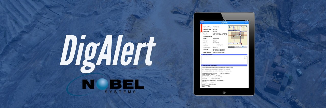
Nobel Systems’ DigAlert is a mobile Geographic Information System workflow process solution that is iPad compatible with fieldwork mobility that improves communications between utility excavators in the field and the DigAlert provider.
The DigAlert Module automatically receives alert tickets from the DigAlert provider, then extracts and synchronizes information to be queried and viewed by the field crews within the mobile device.
Synchronization and Streamlined Workflow
DigAlert uses a synchronization framework that ensures that the most up-to-date tickets—whether complete or in the process—are available in the field and at the company home office automatically.
It does this while notifying colleagues and supervisors that a checkout ticket is in progress. Field crews can make comments or choose from a customizable drop-down menu, along with taking and attaching photos to the ticket. Once the user has filled out the form, they can change the status to complete. This will notify all other users the ticket has been completed and remove it from the list.
The City of Monrovia’s Public Works Division staff uses the DigAlert module to map and manage the City’s Underground Service Alerts (USAs).
City officials have been so satisfied with the system they have contracted for additional Nobel Systems GIS products and services, which includes the company’s flagship product, GeoViewer Online, to meet their ever-evolving maintenance and operational needs.
To learn more about Nobel Systems DigAlert Module and its other GIS and Cloud Solutions, visit Nobel-Systems.com