The colorful sandstone cliffs of Pictured Rocks National Lakeshore is one of the places I have driven close to but never had a chance to stop at and spend a while, but it is on my bucket list.
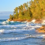
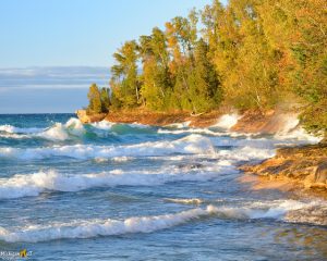
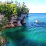
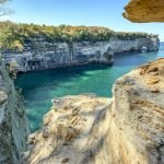
Pictured Rocks National Lakeshore, is full of colorful sandstone cliffs that line the southern shore of Lake Superior in the Upper Peninsula of Michigan. The area extends for some 40 miles northeast of the city of Munising and is about 6 miles across at its widest point. It comprises a 114-square-mile landscape of dunes, beaches, lakes, waterfalls, forests, and shoreline. The national lakeshore is managed in two zones for a total of 73,235 acres. The Shoreline Zone is owned by the National Park Service and includes 33,929 acres. The Inland Buffer Zone is a mixture of State of Michigan, Forestland Group, and other private lands encompassing 39,306 acres. Pictured Rocks were named for the colored stains on the cliff faces produced by dripping groundwater containing iron and other minerals. The cliffs rise 50 to 200 feet above the shoreline. Most of the land is forested with mixed northern hardwoods, fir, spruce, jack pine, and hemlock; stands of white pine were logged to depletion in the early 1900s.
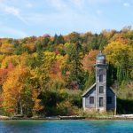
For fifteen miles above Munising, Michigan, sandstone cliffs, some two hundred feet high, rise above Lake Superior and form the beginning for Pictured Rocks. These were dangerous cliffs and waters for travelers. In 1658 trapper Pierre Esprit Radisson the fur trader made this risky passage and noted that his Native American companions made an offering of tobacco to the local spirit of the cliffs. After the fur traders traversed the waterways, settlements began to sprout up along the lake. The logging industry, which had exhausted the white pines of New England by the 1840s while building the nation, sought new supplies. Michigan provided that. The first logging in the Pictured Rocks zone began in 1877 by Joseph Weller; by 1879, he shipped 150,000 cubic feet of wood. By 1882, Weller’s operation was surpassed by Thomas G. Sullivan. In three years, Sullivan cut 50 million feet of white pine. By 1895, a light (Au Sable Light Station) was installed to assist navigation with a light saving station under construction by 1898, manned by the U.S. Life Saving Service until 1940. In October 1966, Congress passed a bill authorizing the establishment of the Pictured Rocks National Lakeshore. This was America’s first National Lakeshore.
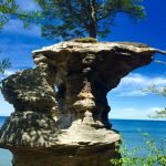
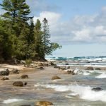
To get the best view of the rocks from the land you should visit the overlooks at Miners Castle, the east end of Miners Beach, and the Lakeshore Trail that runs the length of the park. If you like to hike you will enjoy the nine-mile Chapel Loop trail. This Trail offers views from the highest points of the cliffs. If you do plan to hike atop the cliffs use caution. The Cliffs are soft sandstone some reaching heights of 200 feet which pose a danger especially if the cliffs are undercut by erosion, so stay back from the cliff edge. Whether your visit to the Pictured Rocks Lakeshore lasts only an hour or if you stay for a week or two, you might want to begin your visit at one of the visitor centers located in Munising and Grand Marais. Here you can pick up numerous amounts of brochures and any additional information you need to make your visit outstanding. Near Munising visitors also can view Grand Island, most of which is included in the Grand Island National Recreation Area and is preserved separately. Pictured Rocks National Lakeshore had around half a million visitors last year. Also part of Pictured Rocks National Lakeshore is the Beaver Basin Wilderness which is a United States Wilderness Area. It covers an area of 11,740 acres. It borders 13 miles of Lake Superior shoreline. The North Country Trail has 8.4 miles of trail in the wilderness area.
—- Location —-
Pictured Rocks National Lakeshore is located on the south shore of Lake Superior in Michigan’s Upper Peninsula, between the towns of Munising (west) and Grand Marais (east). Access the west side of the park via Michigan highways M-28 and M-94 to Munising. State highway M-77 leads to Grand Marais on the east side. Alger County Road H-58 runs parallel and through the park, providing access to spur roads that lead to scenic overlooks, trailheads, campgrounds, beaches, etc. Many roads are closed in winter due to snow. Grass airfields are located near Grand Marais and Munising. Regularly scheduled commercial airline service arrives at Marquette, Escanaba, and Sault Ste. Marie, Michigan. (The Marquette airport was an Air Force base and has some international flights as well as daily flights to Detroit or Chicago).
—- Park Camping —-
Pictured Rocks National Lakeshore campsites are rustic and do not have electric, telephone, water, or sewer hookups. Campsites provide a picnic table, fire ring with grill grate, and tent pad. The campgrounds have vault toilets and well water. Typically there is no cell phone reception. There are three campgrounds within Pictured Rocks National Lakeshore. Little Beaver Lake Campground is a small campground having 8 sites. One campsite is disabled accessible. Single unit vehicles in excess of 36 feet and vehicle/trailer combined units in excess of 42 feet are prohibited at Little Beaver because of the small campsites and the narrow, twisting, hilly access road. Hurricane River Campground is a 21-site campground. Because the turning radius is limited within this campground, it is recommended that single vehicles be no more than 36 feet and vehicle/trailer combined length to be no more than 42 feet. Eleven campsites are available in the lower campground loop and ten in the upper loop. Both loops include one disabled accessible campsite. Several campsites are designated as generator-free. Twelvemile Beach Campground has 36 sites which are located on a high sandy plateau above Twelvemile Beach on Lake Superior. The most popular sites have a lake view. Because of the turning radius within this campground, it is recommended that there be only single vehicles no more than 36 feet and vehicle/trailer combined length no more than 42 feet. There are two disabled accessible campsites. Generator use is prohibited in the campground’s west loop. There are three sets of stairs to the beach as well as a day-use picnic area and parking.
—- Free Camping —-
Based on https://freecampsites.net/#!pictured%20rocks%20national%20lakeshore&research=1 there are 10 free campsites within 43 miles of Pictured Rocks National Lakeshore.
—- Area Camping —-
https://www.hipcamp.com/discover/michigan/pictured-rocks/2-tents,vans,trailers?
https://koa.com/campgrounds/pictured-rocks/
https://www.allstays.com/Campgrounds-details/21616.htm
https://www.nps.gov/piro/planyourvisit/nearby-Michigan-state-forest-campgrounds.htm
https://www.fs.usda.gov/activity/hiawatha/recreation/camping-cabins
https://www.nps.gov/piro/planyourvisit/grand-Marais-area-campground.htm
—- Hiking & Biking & Kayaking —-
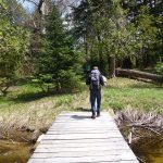
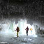
Pictured Rocks National Lakeshore offers some 100 miles of trails. There are several trails to hike in the National Lakeshore including Miners Falls Trail – Length: 1.2 miles round trip. This easy rolling trail takes you through the forest to view the park’s most powerful waterfall from either an upper or lower platform. Chapel Basin/Mosquito Falls Area – Length: Varies, from 2 miles round trip (Mosquito Falls) to 10 miles round trip. A number of different trails and hikes lead through pristine forests to spectacular views of cliffs, beaches, waterfalls, and the famous Chapel Rock. Consult a map of the area before you go. Beaver Basin Wilderness – Length: Varies, 3.2 miles to 5.5 miles round trip. Several hikes can be made in the Beaver Lake area leaving from the trailing parking lot just before Little Beaver Lake Campground. Consult a map of the area before you go. Au Sable Light Station – Length: 3.0 miles round trip. Take an easy walk along the shore from Hurricane River Campground to this isolated Lake Superior lighthouse. Exposed shipwreck remains may be viewed along the way. Guided tours of the lighthouse are provided in summer. Bicycles, including mountain bikes, are not permitted on trails within Pictured Rocks National Lakeshore. The nearby Hiawatha National Forest and Grand Island National Recreation Area offer many opportunities for trail and mountain biking.
https://www.nps.gov/piro/planyourvisit/dayhikes.htm
https://www.alltrails.com/parks/us/michigan/pictured-rocks-national-lakeshore
https://www.hikingproject.com/directory/8014074/pictured-rocks-national-lakeshore
https://www.mtbproject.com/directory/8014074/pictured-rocks-national-lakeshore
https://www.mbtn.org/trails/
https://www.nps.gov/piro/planyourvisit/kayaking.htm
—- Things to do —-
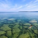
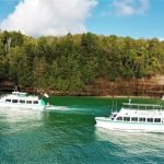
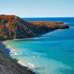
After decades as a sand and gravel road then five years of construction, Alger County H-58 between Grand Marais and Munising was completely paved in 2010, creating one of the most beautiful drives in the Great Lakes region. The road has been engineered as a slow speed, scenic drive through the lakeshore, accessing such popular sites as Sable Falls, Log Slide, Hurricane River, and Twelvemile Beach. Also, some of the best scuba diving in the Midwest can be found in and around Pictured Rocks National Lakeshore. Snorkeling and scuba diving are permitted throughout the lakeshore. Scuba diving is popular in Lake Superior, especially within the Alger Underwater Preserve, a state preserve created to protect the submerged cultural resources. Pictured Rocks Cruises, Inc., offers non-stop narrated boat tours of the spectacular sandstone cliffs within Pictured Rocks National Lakeshore. Each cruise is 2-1/2 to 3 hours long and travels approximately 40 miles round trip. There are also many waterfalls scattered throughout this Park.
https://www.nps.gov/piro/planyourvisit/boat-tour.htm
https://www.nps.gov/piro/planyourvisit/waterfalls.htm
http://www.hiawathashideaway.com/index.php?page=Attractions#anchor
http://www.ohranger.com/pictured-rocks
https://www.michigan.org/article/trip-idea/list-favorite-things-do-pictured-rocks-road-trip
https://www.thingstodointheup.com/pictured-rocks-expert/
—- References —-
https://www.nps.gov/piro/index.htm
https://en.wikipedia.org/wiki/Pictured_Rocks_National_Lakeshore
https://www.munising.org/attractions/pictured-rocks/
https://www.nationalparks.org/connect/scenery-pictured-rocks-national-lakeshore

-
- PICTURED ROCKS NATIONAL LAKESHORE – 2016: Photographer Bryan Mitchell was this years Artist in Residence at Pictured Rocks National Lakeshore in the Upper Peninsula of Michigan from Oct. 1-16, 2016 near Munising, Michigan. (Photo by Bryan Mitchell/Special to Detroit News)