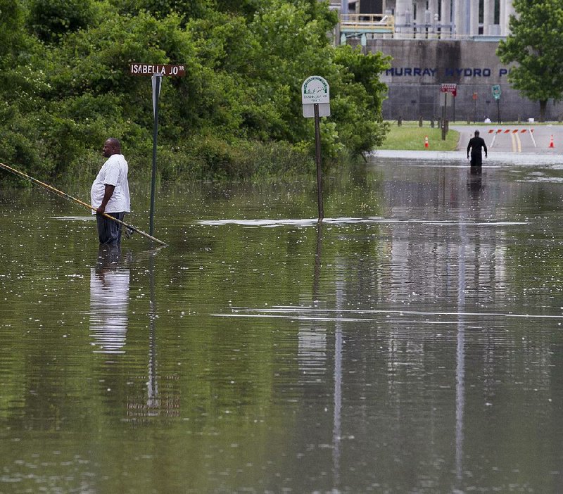
Rising waters forced the closure early Tuesday of three locks and dams on the Arkansas River, holding up barge traffic and flooding low-lying areas.
Storms over the weekend and Monday dumped rain — 8 to 9 inches in places — into the Arkansas River Valley, sending a torrent of runoff, silt and debris into the river, which is now making its way downstream.
“The tugboats’ roadways are under water,” said a worker at the Arthur V. Ormond Lock and Dam in Morrilton who would not give his name. “We had to shut traffic down. There is no navigable point of reference for them. They could actually end up in a farmer’s field.”
Locks and dams at Toad Suck and Fort Smith also closed because of the high waters, said Laurie Driver, a spokesman for the U.S. Army Corps of Engineers. The Fort Smith lock and dam reopened later Tuesday.
“It’s not safe for most of the traffic out there,” she said.
The Corps issued a smallcraft advisory Friday.
The National Weather Service in North Little Rock issued a flood advisory for Little Rock, saying low areas of the Clinton Presidential Center and the William E. “Bill” Clark Wetlands are forecast to flood by this afternoon.
The Arkansas River reached 18.9 feet in Little Rock on Tuesday afternoon and is likely to crest at 21 feet by 1 p.m. today. Flood stage there is 23 feet. The river at Pine Bluff is forecast to crest at 41.9 feet Thursday morning. Flood stage there is 42 feet.
River stages are the comparative level of the surface of a river or stream above an established, standardized gauge at a certain point, rather than a measurement of a river’s depth.
Torrential rains fell in the western half of Arkansas over four days as a cold front inched its way across the state. Fort Smith reported 9.14 inches of rain in a 96-hour period ending at 7 a.m. Monday. De Queen had 8.73 inches of rain, and Russellville recorded 5.93 inches over the same period.
The storm system also spawned a tornado that killed two people late Sunday in Nashville. Authorities said Michael Mooneyhan, 29, and his wife, Melissa, 28, were killed when the twister smashed their mobile home in the western part of the Howard County town about 11:30 p.m. Sunday.
Their 1-year-old daughter, Emily, survived the storm. Firefighters found her beneath the rubble of the destroyed home Sunday night near her parents’ bodies, Nashville Mayor Billy Ray Jones said.
A National Weather Service survey team from Shreveport rated the tornado an EF2, with wind speeds of up to 125 mph. The twister traveled 6.7 miles through Nashville, cutting a 400-yardwide path.
“We’re digging out,” Jones said Tuesday. “We’ve had lots of people helping with the cleanup. We’ve had lots of people from way off sending money for [the Mooneyhans’] funeral. It’s a big deal. There’s a lot of concern.”
Much of the rainfall’s runoff filled creeks, spillways and rivers, ripping culverts out of county roads and leading to several rescue operations.
About 50 people searched for but did not find a 19-yearold Crawford County man who slipped and fell Monday into the swift-running Frog Bayou, Crawford County’s emergency services coordinator Dennis Gilstrap said Tuesday.
The man, whom Gilstrap did not identify, went to the Grotto Hole on the bayou off Arkansas 282 between Alma and Mountainburg with two teenage girls about 3:30 p.m. Monday to swim.
Witnesses said the man slipped into the swift waters and disappeared. Gilstrap said the rapid waters made it difficult for searchers to maneuver boats.
Water receded Tuesday in mountainous Yell County, where flash flooding Sunday and early Monday resulted in a rescue by the Yell County Mounted Patrol.
Four Arkansas Tech University students from Japan tried Sunday evening to cross a water-covered bridge off Arkansas 22 about 3 miles west of Dardanelle when fast-moving waters washed their car off the roadway.
When rescuers arrived, “the car was fully submerged in the floodwaters with only about 6 inches of the roof visible,” said Tom Berryhill, the patrol’s rescue instructor.
Rescue crews were preparing to use a tanker truck, when water flipped the car over and “threw” the women closer to the shore in shallower water. Rescuers quickly grabbed the women as the car tumbled downstream about 200 yards.
The Arkansas River at Dardanelle crested at 37 feet Tuesday, the eighth-highest mark recorded there.
The muddy Arkansas River churned Tuesday, while sightseers gathered on the rocky banks in North Little Rock to watch debris swirl in the turbulent current.
“It’s flowing very fast,” said Anita Ward, owner of the Dam Riverboat Co., on the riverfront. “We’ve got trees coming down.”
Ward said the high waters forced the cancellation of her company’s paddleboat tours of the river.
“We may get more rain Thursday,” she said. “The river’s not wanting to go down.”
The National Weather Service in North Little Rock is calling for a chance of rain Thursday for much of the state.
“How much rain remains to be seen,” meteorologist Dave Scheibe said. “It shouldn’t be heavy rain, but it may slow down the river’s receding.”
High waters also forced the closures of boat ramps, camping grounds and picnic areas at Jacksonport State Park, Daisy State Park, Millwood State Park and Moro Bay State Park, said Joan Ellison, a spokesman for the state parks department.
“This is part of park management,” she said. “We take all safety precautions necessary. We will open them back up as quickly as possible, but our visitors’ safety is the priority.”
Visitors can check park status updates at the parks website at: arkansasstateparks.com arkansasstateparks.com.
Blanchard Springs Caverns, 15 miles northwest of Mountain View, will be closed Thursday while Entergy Arkansas crews repair storm-damaged transformers at the visitor center and the wastewater treatment plant.
The park will reopen Friday, said Terence Peck, a spokesman for the Ouachita, Ozark and St. Francis National Forests.
Officials expected the Arkansas River to continue receding this week farther upstream. The river was forecast to crest at 31.5 feet at its last gauge in Pendleton before emptying into the Mississippi River at 1 p.m. Thursday.
“Flows are receding at the upper end of the river,” Driver said.
She said the river’s gauge at Ozark measured the stream flow at 200,000 cubic feet per second earlier this week. On Friday, it is likely to recede to 145,000 cubic feet per second. Normally, the river flows at 20,000 cubic feet per second, she said.
Driver said the river’s rise is the fourth-highest measured since the opening of the McClellan-Kerr Arkansas River Navigation System in 1971.
“The water all eventually goes down the river,” Driver said. “There’s been lots of water. It has to go somewhere.”
Information for this article was contributed by Dave Hughes and Debra Hale-Shelton of the Arkansas Democrat-Gazette.