
Take a guided tour of UK skies
17 November 2014Following the success of our two data visualisations – Europe 24 and North Atlantic Skies – we’ve taken a lot of time to think about where to go next – it’s been a typical case of ‘difficult second album syndrome’.
Both Europe 24 and North Atlantic Skies were designed to give an overview of the daily complexity and volumes of air traffic across the UK and Europe and to do so in a way that was cinematic and exciting to watch. I think we were able to do that to great effect, but we now want to take you a little deeper.
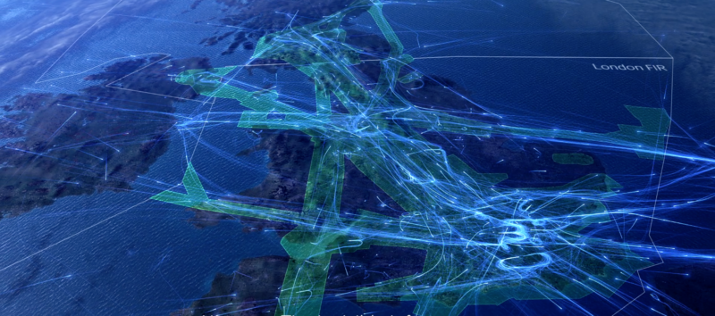
We are therefore very excited to publish UK 24 – your guided tour to some of what makes UK aviation work.
Our airspace is busy, complex and there is a lot going on. Each year we manage around 2.2 million movements, peaking at over 8,000 a day (although there are around 7,000 on this particular day), with only 5.5 seconds delay per flight attributable to NATS. Obviously there are the flows of large aircraft from the airports into and out of the UK, but there is also a lot of activity outside controlled airspace. UK 24 is designed to help visualise the breadth and depth of UK aviation and why airspace is such an important asset.
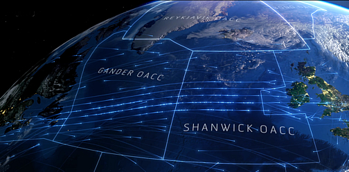
The day starts with the bow wave of transatlantic traffic heading towards the UK on their organised and separated tracks. This is quickly joined by traffic from Europe and the first waves of departures from UK airports. Over a short period of time the traffic levels grow to show the main trunk roads of airspace as well as the hubs around London, Manchester and central Scotland.

We then move to give a unique view of the holding stacks over London and how they are a fundamental part of the Heathrow operation, providing the constant flow of traffic that makes it the world’s busiest dual runway airport with 1,350 movements a day.
Our tour then take us around the UK, including the other major airports, our two control centres in Swanwick and Prestwick, some general aviation traffic and examples of military training off the east coast of England and near to North Wales. We then dwell on the spider’s web of helicopter tracks that originate from Aberdeen, taking people and vital supplies to and from the North Sea oil and gas rigs.

We hope you enjoy this insight into the complexity and beauty of a day of UK air traffic and the value of airspace as the invisible infrastructure that makes it all work.
Incidentally, we’ve also produced a more simple static video showing an overview of the UK that you can watch here too.
Let us know what you think.
Value of aviation to the UK economy
The aviation sector and its supply chain generates over £20bn per year in economic output and directly employs circa 220,000 people. At Heathrow alone, goods worth £133 billion were shipped in and out last year, more than the combined value of goods transiting through the UK’s two largest ports, Felixstowe and Southampton.
Aviation is on average a much more productive sector than the rest of the economy; each pound spent on upgrading our aviation infrastructure is expected to generate over £5 in return. In addition aviation is a significant growth sector within key regions for UK trade, for example China, the Middle East and Turkey have ambitious plans to more than double their capacity.
Without additional capacity in the UK, we risk the rapid growth in traffic and its associated commerce being focused elsewhere.
You may also be interested in...
North Atlantic Skies – The gateway to Europe
Read more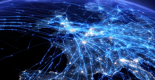
Europe 24 – an air traffic data visualisation
Read moreComments
Please respect our commenting policy and guidelines when posting on this website.
17.11.2014
13:40
Steve Balfour
‘Second album’ Brendan? Are you sure this is not a re-released ‘de-luxe edition’? I’ve had something very similar on my hard-drive for about 9 months. I fact, I nearly used it at a presentation a week-or-so back, but we ran out of time. Hope you’re well.
17.11.2014
18:07
Rob
Why always mention Heathrow? What Gatwick has achieved, with regards to movements per hour, under NATS control is more impressive (speaking as a non-approach, LTMA controller). The fact we have the busiest single and dual runway operations within 20 miles of each other is also worthy of mention. All in all, another impressive video.
17.11.2014
18:43
ross savage
Fantastic visual, absolutely mesmerising!
Ross, BA Dispatch LHR
17.11.2014
22:58
Paul, Airservices
Superb! Great work, guys – very impressive…
18.11.2014
06:32
Linda James
What a wonderful experience 🙂
18.11.2014
07:47
Roly
Glad Aberdeen has been included to show that it is not a quiet little airfield in N.E. Scotland!
18.11.2014
11:57
Paul Dickerson
There are a couple of places where there appears to a high altitude aircraft following a perfectly circular hold over the Yorkshire/Durham area and over the Shetland/Orkney area – what are these?
18.11.2014
13:50
Jimbo
where is London Southend Airport?
18.11.2014
14:22
Paul Beauchamp
Senior Communications Manager, Brand PR & Marketing CommunicationsHi Paul, thanks for commenting. These are military training AWACS – Airborne Warning and Control System – flights. You can read more about them here: http://en.wikipedia.org/wiki/Airborne_early_warning_and_control. I hope that helps. Paul
14:22
Paul Beauchamp
Senior Communications Manager, Brand PR & Marketing Communications18.11.2014
16:20
kechhahalkhabar
Absolutely loved watching this 🙂
18.11.2014
18:51
Peter Heath
Fascinating viewing Brendan! Shame its not longer – could watch it over and over again
18.11.2014
18:57
Susie
Really great film, I loved watching it. Does anyone know what the accompanying sound track is called please?
18.11.2014
19:11
Bryan
Is this derived from internal only data? I have been curious about mapping 2 dimensionally, hot spot areas of the U.S. for elementary school purposes.
18.11.2014
19:51
chris allan
A great visualisation of a world that is taken for granted by most travelling public, yet one that has taken decades to create.
19.11.2014
05:38
Graham
Does any one know the name of the music being played on the video ?
19.11.2014
10:31
Matthew Mills
Head of Digital CommsThank you for your feedback everyone.
For info – the music is called ‘Golden Mile’ from an album called ‘Inspiration’ and is credited to Marc Vickers, Paul Plant, Jem Godfrey and Ian Wish.
It’s available from Focus Music: http://www.focusmusic.com/
10:31
Matthew Mills
Head of Digital Comms19.11.2014
11:27
Scott Rayne
Gatwick is just NOT London. So please continue to NOT mention Gatwick. I hate Gatwick! If there is no TUBE connection, you CANNOT be a London hub. Heathrow and London City are by far the ONLY airport you SHOULD invest in further. FORGET Gatwick, it’s far by car, far by rail and far BEHIND the levels of service you get at London City and Heathrow! I am GLAD you DID NOT mention Gatwick! Hoora!
19.11.2014
11:54
Kevin
Amazing
19.11.2014
12:50
Mrs M Green
My daughter worked at Nats and her hubby works at controlling air traffic, so we are interested in their work. Had no idea it was so busy up there, brilliant viewing fastinating stuff. Respect to all who keep our airways safe.
From Madeleine Green.
19.11.2014
13:01
Maria
Why is the north of England completely missing from this video?
19.11.2014
21:45
Alex
I would love to see a similar visualization of how weather affects air traffic such as when winds shift to the East, requiring a reversal of the normal flow of arrival and departure traffic.
19.11.2014
22:16
JetForMe
Any chance you could do a beautiful version of this animation ? Watching the storm cells move through, and the planes be vectored around them, is mesmerizing. It doesn’t have to be ATL, but I don’t know if other airports have the same volume of traffic and weather.
Thank you.
19.11.2014
22:59
Commsguy
What a superb video – Comms professional from an unrelated discipline!
19.11.2014
23:03
peter Goulding
Absolutely brilliant. Worth watching more than just a few times.
20.11.2014
13:33
danielpaul94
Wow. 🙂
20.11.2014
19:20
Steve Algieri
Just had to say as a visualisation, this series has been some of the most beautiful I’ve ever seen. Really great job.
20.11.2014
20:33
SAC
Amazing and very inspiring visualisation!
21.11.2014
04:26
Arvind
Awesome information and beautifully visualized! As a data scientist, I am very curious to understand what software was used to produce these 3-d spatial visualizations. Could you share?
21.11.2014
10:19
TAP
Jimbo, FYI SEN is to the right of LHR.
21.11.2014
13:50
Matthew Mills
Head of Digital Comms@Arvind
Our visualisations are made using a combination of bespoke and commercially available software.
A custom made Java program reformats our radar and flight plan data into something that Maya 3D can work with. It’s then a case of taking layers from Maya 3D and compositing them in After Effects and then editing with captions, music etc. in Final Cut X.
13:50
Matthew Mills
Head of Digital Comms23.11.2014
21:46
stan russell
brilliantly done, very interesting, very well put together and very scary. only glad is it is you and not me and as a frequent flyer in the skies over london every week, keep up the good work!!
25.11.2014
16:21
Sam Morton IOM
Wow! Really interesting. Thanks for publishing.
26.11.2014
15:54
Raymond Dunthorne
Great work, stunning visual and important final paragraph re: the value of aviation to the UK economy.
With economic growth looking like it’s coming from Asia, North and South America over coming years, the rampant political dithering around airport expansion (obviously both Heathrow AND Gatwick need an additional runway) could cost the UK dearly.
Didn’t it look like Dubai was going to have more international movements than Heathrow this year?
My respect goes to the entire aviation industry, its commitment, professionalism and relentlessly high standards.
The incumbent and one or two previous UK Governments should apologise to us all for consistent lack of vision.
03.12.2014
22:17
Mike McSharry
I saw the UK visualisation last week.
A few days ago I wanted to teach some year 5 pupils about how networks are all around them and your visualisation would have been incredible.
Unfortunately it is on Vimeo (which i use for other reasons) which is completely blocked in many schools.
Is there any way I could get a copy of the video on to my own site, which is not blocked. Obviously I would give all accreditation to your organisation.
04.12.2014
13:18
Paul Beauchamp
Senior Communications Manager, Brand PR & Marketing CommunicationsHi Mike, thanks for your comment and it sounds like a great idea. The video is also available on YouTube if that helps (https://www.youtube.com/watch?v=a8CQ29yWvZI) or alternatively if you can access Vimeo away from work you can download the file directly from the page:
[vimeo 110348926 w=600 h=338]I hope that works and let us know how it goes down with your pupils! Paul
13:18
Paul Beauchamp
Senior Communications Manager, Brand PR & Marketing Communications13.12.2014
20:29
Vincent
Hi!
First of all, kudos for these gobsmacking videos. Breath-taking. Really.
Everything is right from the illumination of the Sun, the aerial photography projected on the DEM to the size of the planes, the colors, transparency and persistence of the trajectories, the 3D polygonal R or F-zone representation, etc. Awesome.
As a chief editor of a (French) magazine dedicated to GIS, I’d be delighted to write an article on the technical aspects of these first-class videos: software used – GIS, database if any – graphical choices, time passed on the footage, etc. Would that be possible?
Thanks and carry on the good job, both in the skies above and here over the Internet!
31.12.2014
22:46
Bernie Regan
What a brilliant visualisation of the air traffic picture above us. Seriously impressed. Excellent work….
21.03.2015
23:17
Marlene Sonnenberg
Seriously amazing! Well done to the traffic controllers.
20.04.2015
09:37
Stephen Brown
Fantastic!
I would have liked it to finish with the Westbound North Atlantic flow as it started with the Eastbound North Atlantic flow.
23.04.2015
13:29
becky
Who were the illustrators behind this? It’s amazing!
24.04.2015
09:22
Paul Beauchamp
Senior Communications Manager, Brand PR & Marketing CommunicationsHi Becky, we worked with a fantastic company in Bristol called 422 South – http://422.com/
09:22
Paul Beauchamp
Senior Communications Manager, Brand PR & Marketing Communications25.11.2015
15:00
Rais. Ahmed
It’s a very complex system, made easy for aircraft movement in such massive air traffic.
19.01.2016
20:16
william
Between 16.20hrs and 16.50hrs today tues. 19th jan 2016 i saw twelve multi-engined large jets being flown south to north about five miles west of worcester city, they were almost in formation, i.e. fyling at the same altitude and on the same flite path, i have never seen that in this area over the last thirty years, any ideas?
06.04.2016
14:28
tracy thompson
I find all of your comments infuriating, beautiful???, you should try living under one of these flight paths. The film clip has just highlighted how much air traffic is passing overhead. Today flights are passing over Cardigan in West Wales continuously the noise is horrendous a constant roaring as planes pass above with very few breaks. Over the years this has increased to an unacceptable noise level. This area of the UK you would expect to be peaceful. To be honest I am sick of it and also infuriated because I have been trawling round the NATS site for an hour or more trying to find information as to why so many air craft are concentrated over this area and why they are not spread out across the UK north to south to give people a bit of peace. Can anyone tell me who I contact to get more info. I rang the number provided and it just rang and rang and then cut out. I want detailed info on flight paths, what height air craft is flying, at what height they should be flying at, who I can speak to about my concerns and how I can campaign to have traffic no longer concentrated so much in one area.??????
15.04.2016
12:25
michael king
I live in Central Scotland and frequently the transatlantic traffic overflies us
Could you tell me what the frequency is to listen to ATC for transatlantic traffic
20.04.2016
18:06
js
I live in monmouthshire on the same westbound Atlantic Flightpath and have also been trying to find out why this concentration of aircraft has happened since autumn 2014. One every three minutes, often several at once. I have written to everyone I can think of and always receive the same reply…that aircraft above 25,000ft are barely audible and that it is not therefore deemed necessary to undertake any analyses of the acoustic impact of concentrated Flightpaths in rural areas. Please undertake acoustic survey work and please consider using the new navigation technology to rotate concentrated flightpaths everywhere, not just close to the London airports. We all share responsibility to reduce emissions but in principle it cannot be right to accept PBN is problematic below 7,000 ft but somehow not a problem above 7,000ft, regardless of ambient noise level.
01.07.2016
17:16
Jon
These NATS visualizations are the best and most realistic in their presentation. Unlike the FAA and their unrealistic 2-dimensional replays, where each aircraft symbol depicted is the equivalent of 30 miles long! In an misleading attempt to make U.S. skies appear completely “covered” by aircraft. (rolls eyes)
24.11.2016
15:53
matthew craig
it seems no one is willing to accept the FACT that aircraft at 35 to 40 000 ft are noisy on the ground the flight path over the cardigan area is audiable at up to 58db down the teifi valley many of these flights could be given a much shorter route over the sea why are the authorities in denial ? a reply from someone at nats would be appreciated .
28.01.2019
15:44
Jo Grundy
We live in Cumbria and are interested and concerned to know whether planes are allowed to fly over Sellafield?
17.10.2020
18:05
baladuhan
JTM have the capacity to move air cargo globally. In addition, we leverage other logistics services as needed to assist with air shipments