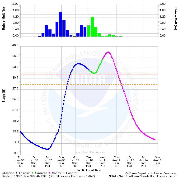
Update, 7:30 a.m. Wednesday:The California-Nevada River Forecast Center's latest estimate of the Russian River's crest at Guerneville says the waterway will peak at about 5½ feet over flood stage. That's down 2 feet from the forecast last night for a 39.8-foot crest, which would have significantly widened the inundated area. The CNRFC's next forecast is due out at 9 a.m.
Update, 10:35 p.m.: The California-Nevada River Forecast Center has updated its forecast for flooding on the Russian River at Guerneville -- and it's not good news for communities along the waterway's lower reaches.
The new forecast, released after 9 p.m., estimates the river will rise to 39.8 feet by Wednesday evening, then recede to below flood level Thursday afternoon. The new forecast is 7.8 feet above flood stage.
Earlier in the day, Sonoma County issued an evacuation advisory based on a flood level of 38.3 feet and estimated about 100 structures would be affected, on top of the 550 that have already been flooded. We don't have a figure yet on how many additional homes and businesses could be in the water as the flood approaches 40 feet. Here's a snippet from the general description of flood impacts from the river forecast center:
39.0 Feet: Significant flooding is expected to occur along the lower portions of the Russian River. River Road, along with a few houses, will flood at the town of Hacienda. Armstrong Woods Road, 4th Street, and Mill Street are forecast to flood. The village of Northwood Grove and Monte Rio School are expected to become inundated.
40.0 Feet: Major flooding is expected along the Russian River. Many roads in Guerneville, Monte Rio, Rio Nido, and Hacienda will be flooded.
Update, 9:30 p.m.: Downpours throughout the Bay Area prompted a series of flash flood warnings and ongoing worries about flooding along the Russian River.
Sponsored
During the day, flood warnings or flash flood warnings were in force through Wednesday morning for dozens of communities in every Bay Area county as prolonged heavy rain fell on terrain already saturated by storms last week and over the weekend.
The National Weather Service issued flash flood warnings as creeks rose rapidly in parts of Sonoma, Marin, Napa, Alameda, Santa Clara and Santa Cruz counties. Early Tuesday evening, flood sirens warned residents in flood-prone areas of the Marin communities of Fairfax, San Anselmo and Ross to move to higher ground as local creeks reached capacity.
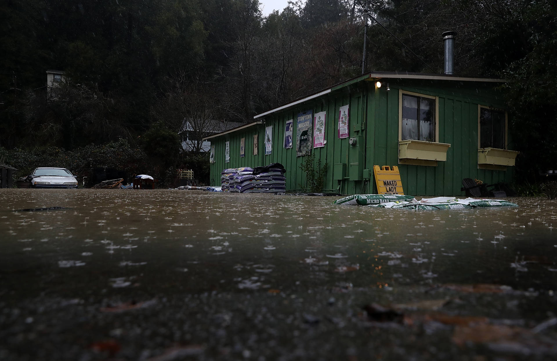
As the main body of Tuesday's storm passed to the east Tuesday evening -- yes, it really looks like the pounding is over for the time being -- Sonoma County still appears to have suffered the most severe impacts of the deluge.
The county lists 45 road closures due to flooding, slides and downed trees or power lines. Large swaths of agricultural land are under water. County officials say that at least 550 homes and businesses near the Russian River near Guerneville have been flooded -- a number expected to grow by at least 100 as the river reaches a crest forecast to be 6 feet over flood stage on Wednesday evening.
Scattered showers are expected overnight into Wednesday, followed by a weaker storm Thursday that could still drop another 1 to 2 inches at the Bay Area's wettest locations.
Some precipitation highlights for the 24 hours ending at 9 p.m. Tuesday:
Venado (Sonoma County): 6.40 inches Kentfield (Marin County): 6.11 Boulder Creek (Santa Cruz Mountains): 5.24 inches St. Mary's College (Moraga): 5.02 inches Vollmer Peak (Berkeley Hills): 3.30 inches
Urban totals include:
Santa Rosa: 2.92 inches San Rafael: 3.86 inches Richmond: 1.96 inches Downtown San Francisco: 1.21 inches Oakland International Airport: 1.53 inches San Jose International Airport: .60 inches
Original post: Another day, another relentless rainy torrent.
Our third major storm of 2017, fueled once more by subtropical moisture, has dumped heavy rain across most of the Bay Area. Occasionally heavy precipitation is expected to continue late into the evening before breaking up into scattered showers Wednesday.
The major concern in the region is flooding, and much of the attention is focused in the North Bay, especially the lower Russian River in Sonoma County. During the course of the day, the National Weather Service issued flood and flash flood warnings for large swaths of the county, including areas near Healdsburg, Geyserville, Sebastopol, Santa Rosa, Petaluma and the town of Sonoma. On the other end of the Bay Area, the service issued a flash flood warning for parts of Los Gatos as Lexington Reservoir reached capacity and sent water into Los Gatos Creek.
In western Sonoma County, the Russian River crested at 3 feet above flood stage in Guerneville on Monday, flooding hundreds of homes and businesses in the resort town and nearby communities. After the river receded to just above flood stage today, the California-Nevada River Forecast Center says the Russian is expected to rise to about 6½ over flood stage by Wednesday evening, inundating even more property.
California-Nevada Forecast center forecast for Russian River at Guerneville. (CNRFC)
After a brief break from the major weekend storm, heavy rain resumed across the watershed late Monday and continued without respite Tuesday.
Among locations widely watched for gauging the intensity of rainfall that will wind up as runoff cascading into the Russian River are Venado, in the hills west of Healdsburg, and Cazadero, in the hills north of the river near the community of Duncans Mills.
For the month so far, Venado has recorded about 24 inches of rain for a total of 69.48 inches since Oct. 1, the start of California's official water year.
Unofficially -- meaning from our own reading of Department of Water Resources and National Weather Service numbers -- that ranks Venado as No. 3 on the list of rainiest places in the state so far this water year. No. 1 appears to be Four Trees, a place in the mountains of Plumas County, which had gotten 73.52 inches as of midnight Monday; No. 2 is the Mattole River hamlet of Honeydew, in western Humboldt County, with 70.24
Sponsored
This post will be updated.
lower waypoint
Stay in touch. Sign up for our daily newsletter.
To learn more about how we use your information, please read our privacy policy.
window.__IS_SSR__=true
window.__INITIAL_STATE__={"attachmentsReducer":{"audio_0":{"type":"attachments","id":"audio_0","imgSizes":{"kqedFullSize":{"file":"https://ww2.kqed.org/news/wp-content/themes/KQED-unified/img/audio_bgs/background0.jpg"}}},"audio_1":{"type":"attachments","id":"audio_1","imgSizes":{"kqedFullSize":{"file":"https://ww2.kqed.org/news/wp-content/themes/KQED-unified/img/audio_bgs/background1.jpg"}}},"audio_2":{"type":"attachments","id":"audio_2","imgSizes":{"kqedFullSize":{"file":"https://ww2.kqed.org/news/wp-content/themes/KQED-unified/img/audio_bgs/background2.jpg"}}},"audio_3":{"type":"attachments","id":"audio_3","imgSizes":{"kqedFullSize":{"file":"https://ww2.kqed.org/news/wp-content/themes/KQED-unified/img/audio_bgs/background3.jpg"}}},"audio_4":{"type":"attachments","id":"audio_4","imgSizes":{"kqedFullSize":{"file":"https://ww2.kqed.org/news/wp-content/themes/KQED-unified/img/audio_bgs/background4.jpg"}}},"placeholder":{"type":"attachments","id":"placeholder","imgSizes":{"thumbnail":{"file":"https://ww2.kqed.org/wp-content/uploads/sites/10/2018/01/GettyImages-896326950-160x96.jpg","width":160,"height":96,"mimeType":"image/jpeg"},"medium":{"file":"https://ww2.kqed.org/wp-content/uploads/sites/10/2018/01/GettyImages-896326950-800x478.jpg","width":800,"height":478,"mimeType":"image/jpeg"},"large":{"file":"https://ww2.kqed.org/wp-content/uploads/sites/10/2018/01/GettyImages-896326950-1020x610.jpg","width":1020,"height":610,"mimeType":"image/jpeg"},"fd-lrg":{"file":"https://ww2.kqed.org/wp-content/uploads/sites/10/2018/01/GettyImages-896326950-1920x1148.jpg","width":1920,"height":1148,"mimeType":"image/jpeg"},"fd-med":{"file":"https://ww2.kqed.org/wp-content/uploads/sites/10/2018/01/GettyImages-896326950-1180x705.jpg","width":1180,"height":705,"mimeType":"image/jpeg"},"fd-sm":{"file":"https://ww2.kqed.org/wp-content/uploads/sites/10/2018/01/GettyImages-896326950-960x574.jpg","width":960,"height":574,"mimeType":"image/jpeg"},"post-thumbnail":{"file":"https://ww2.kqed.org/wp-content/uploads/sites/10/2018/01/GettyImages-896326950-672x372.jpg","width":672,"height":372,"mimeType":"image/jpeg"},"twentyfourteen-full-width":{"file":"https://ww2.kqed.org/wp-content/uploads/sites/10/2018/01/GettyImages-896326950-1038x576.jpg","width":1038,"height":576,"mimeType":"image/jpeg"},"xxsmall":{"file":"https://ww2.kqed.org/wp-content/uploads/sites/10/2018/01/GettyImages-896326950-240x143.jpg","width":240,"height":143,"mimeType":"image/jpeg"},"xsmall":{"file":"https://ww2.kqed.org/wp-content/uploads/sites/10/2018/01/GettyImages-896326950-375x224.jpg","width":375,"height":224,"mimeType":"image/jpeg"},"small":{"file":"https://ww2.kqed.org/wp-content/uploads/sites/10/2018/01/GettyImages-896326950-520x311.jpg","width":520,"height":311,"mimeType":"image/jpeg"},"xlarge":{"file":"https://ww2.kqed.org/wp-content/uploads/sites/10/2018/01/GettyImages-896326950-1180x705.jpg","width":1180,"height":705,"mimeType":"image/jpeg"},"full-width":{"file":"https://ww2.kqed.org/wp-content/uploads/sites/10/2018/01/GettyImages-896326950-1920x1148.jpg","width":1920,"height":1148,"mimeType":"image/jpeg"},"guest-author-32":{"file":"https://ww2.kqed.org/wp-content/uploads/sites/10/2018/01/GettyImages-896326950-32x32.jpg","width":32,"height":32,"mimeType":"image/jpeg"},"guest-author-50":{"file":"https://ww2.kqed.org/wp-content/uploads/sites/10/2018/01/GettyImages-896326950-50x50.jpg","width":50,"height":50,"mimeType":"image/jpeg"},"guest-author-64":{"file":"https://ww2.kqed.org/wp-content/uploads/sites/10/2018/01/GettyImages-896326950-64x64.jpg","width":64,"height":64,"mimeType":"image/jpeg"},"guest-author-96":{"file":"https://ww2.kqed.org/wp-content/uploads/sites/10/2018/01/GettyImages-896326950-96x96.jpg","width":96,"height":96,"mimeType":"image/jpeg"},"guest-author-128":{"file":"https://ww2.kqed.org/wp-content/uploads/sites/10/2018/01/GettyImages-896326950-128x128.jpg","width":128,"height":128,"mimeType":"image/jpeg"},"detail":{"file":"https://ww2.kqed.org/wp-content/uploads/sites/10/2018/01/GettyImages-896326950-150x150.jpg","width":150,"height":150,"mimeType":"image/jpeg"},"kqedFullSize":{"file":"https://ww2.kqed.org/wp-content/uploads/sites/10/2018/01/GettyImages-896326950-e1514998105161.jpg","width":1920,"height":1148}}},"news_11982923":{"type":"attachments","id":"news_11982923","meta":{"index":"attachments_1591205162","site":"news","id":"11982923","found":true},"title":"Elementary boy reads alone next to window","publishDate":1713126369,"status":"inherit","parent":11982920,"modified":1713126575,"caption":"An elementary student reads on his own in class.","credit":"Allison Shelley/American Education","altTag":"A young boy wearing a white hoodie and black pants reads a book while sitting down.","description":null,"imgSizes":{"medium":{"file":"https://cdn.kqed.org/wp-content/uploads/sites/10/2024/04/Reading-book-2048x1468-1-800x573.jpg","width":800,"height":573,"mimeType":"image/jpeg"},"large":{"file":"https://cdn.kqed.org/wp-content/uploads/sites/10/2024/04/Reading-book-2048x1468-1-1020x731.jpg","width":1020,"height":731,"mimeType":"image/jpeg"},"thumbnail":{"file":"https://cdn.kqed.org/wp-content/uploads/sites/10/2024/04/Reading-book-2048x1468-1-160x115.jpg","width":160,"height":115,"mimeType":"image/jpeg"},"1536x1536":{"file":"https://cdn.kqed.org/wp-content/uploads/sites/10/2024/04/Reading-book-2048x1468-1-1536x1101.jpg","width":1536,"height":1101,"mimeType":"image/jpeg"},"post-thumbnail":{"file":"https://cdn.kqed.org/wp-content/uploads/sites/10/2024/04/Reading-book-2048x1468-1-672x372.jpg","width":672,"height":372,"mimeType":"image/jpeg"},"twentyfourteen-full-width":{"file":"https://cdn.kqed.org/wp-content/uploads/sites/10/2024/04/Reading-book-2048x1468-1-1038x576.jpg","width":1038,"height":576,"mimeType":"image/jpeg"},"full-width":{"file":"https://cdn.kqed.org/wp-content/uploads/sites/10/2024/04/Reading-book-2048x1468-1-1920x1376.jpg","width":1920,"height":1376,"mimeType":"image/jpeg"},"kqedFullSize":{"file":"https://cdn.kqed.org/wp-content/uploads/sites/10/2024/04/Reading-book-2048x1468-1.jpg","width":2048,"height":1468}},"fetchFailed":false,"isLoading":false},"news_11982958":{"type":"attachments","id":"news_11982958","meta":{"index":"attachments_1591205162","site":"news","id":"11982958","found":true},"title":"DSC_0183","publishDate":1713195865,"status":"inherit","parent":11982940,"modified":1713196211,"caption":"Demonstrators shut down the southbound lanes of I-880 Monday morning in West Oakland. The protesters, engaging in a multi-city 'economic blockade in solidarity with Palestine,' marched from the West Oakland BART station to the 7th Street on-ramp and onto the freeway.","credit":"Beth LaBerge/KQED","altTag":null,"description":null,"imgSizes":{"medium":{"file":"https://cdn.kqed.org/wp-content/uploads/sites/10/2024/04/DSC_0183-800x533.jpg","width":800,"height":533,"mimeType":"image/jpeg"},"large":{"file":"https://cdn.kqed.org/wp-content/uploads/sites/10/2024/04/DSC_0183-1020x680.jpg","width":1020,"height":680,"mimeType":"image/jpeg"},"thumbnail":{"file":"https://cdn.kqed.org/wp-content/uploads/sites/10/2024/04/DSC_0183-160x107.jpg","width":160,"height":107,"mimeType":"image/jpeg"},"1536x1536":{"file":"https://cdn.kqed.org/wp-content/uploads/sites/10/2024/04/DSC_0183-1536x1024.jpg","width":1536,"height":1024,"mimeType":"image/jpeg"},"post-thumbnail":{"file":"https://cdn.kqed.org/wp-content/uploads/sites/10/2024/04/DSC_0183-672x372.jpg","width":672,"height":372,"mimeType":"image/jpeg"},"twentyfourteen-full-width":{"file":"https://cdn.kqed.org/wp-content/uploads/sites/10/2024/04/DSC_0183-1038x576.jpg","width":1038,"height":576,"mimeType":"image/jpeg"},"kqedFullSize":{"file":"https://cdn.kqed.org/wp-content/uploads/sites/10/2024/04/DSC_0183.jpg","width":1620,"height":1080}},"fetchFailed":false,"isLoading":false},"news_11983096":{"type":"attachments","id":"news_11983096","meta":{"index":"attachments_1591205162","site":"news","id":"11983096","found":true},"title":"Pamela Price, candidate for Alameda County District Attorney, talks to the Chronicle editorial board on Wednesday, May 23, 2018 in San Francisco, Calif.","publishDate":1713229084,"status":"inherit","parent":11983091,"modified":1713229219,"caption":"Alameda County District Attorney Pamela Price was in office less than six months before the recall campaign was launched against her.","credit":"Lea Suzuki/The San Francisco Chronicle via Getty Images","altTag":null,"description":null,"imgSizes":{"medium":{"file":"https://cdn.kqed.org/wp-content/uploads/sites/10/2024/04/GettyImages-1322368723-800x534.jpeg","width":800,"height":534,"mimeType":"image/jpeg"},"large":{"file":"https://cdn.kqed.org/wp-content/uploads/sites/10/2024/04/GettyImages-1322368723-1020x680.jpeg","width":1020,"height":680,"mimeType":"image/jpeg"},"thumbnail":{"file":"https://cdn.kqed.org/wp-content/uploads/sites/10/2024/04/GettyImages-1322368723-160x107.jpeg","width":160,"height":107,"mimeType":"image/jpeg"},"post-thumbnail":{"file":"https://cdn.kqed.org/wp-content/uploads/sites/10/2024/04/GettyImages-1322368723-672x372.jpeg","width":672,"height":372,"mimeType":"image/jpeg"},"twentyfourteen-full-width":{"file":"https://cdn.kqed.org/wp-content/uploads/sites/10/2024/04/GettyImages-1322368723-1024x576.jpeg","width":1024,"height":576,"mimeType":"image/jpeg"},"kqedFullSize":{"file":"https://cdn.kqed.org/wp-content/uploads/sites/10/2024/04/GettyImages-1322368723.jpeg","width":1024,"height":683}},"fetchFailed":false,"isLoading":false},"news_11981910":{"type":"attachments","id":"news_11981910","meta":{"index":"attachments_1591205162","site":"news","id":"11981910","found":true},"title":"240404-FORCED STERILIZATION-MOONLIGHT_03-KQED","publishDate":1712251371,"status":"inherit","parent":0,"modified":1712966037,"caption":"Moonlight Pulido at her home in Carson on Feb. 10, 2024. While incarcerated in 2005, a doctor performed a hysterectomy on Pulido without her consent. A law required California to involve survivors in memorializing the state's history of forced sterilization. Survivors say that didn’t happen — so they undertook their own project of healing.","credit":"Cayla Mihalovich for KQED","altTag":null,"description":null,"imgSizes":{"medium":{"file":"https://cdn.kqed.org/wp-content/uploads/sites/10/2024/04/240404-FORCED-STERILIZATION-MOONLIGHT_03-KQED-800x533.jpg","width":800,"height":533,"mimeType":"image/jpeg"},"large":{"file":"https://cdn.kqed.org/wp-content/uploads/sites/10/2024/04/240404-FORCED-STERILIZATION-MOONLIGHT_03-KQED-1020x680.jpg","width":1020,"height":680,"mimeType":"image/jpeg"},"thumbnail":{"file":"https://cdn.kqed.org/wp-content/uploads/sites/10/2024/04/240404-FORCED-STERILIZATION-MOONLIGHT_03-KQED-160x107.jpg","width":160,"height":107,"mimeType":"image/jpeg"},"1536x1536":{"file":"https://cdn.kqed.org/wp-content/uploads/sites/10/2024/04/240404-FORCED-STERILIZATION-MOONLIGHT_03-KQED-1536x1024.jpg","width":1536,"height":1024,"mimeType":"image/jpeg"},"post-thumbnail":{"file":"https://cdn.kqed.org/wp-content/uploads/sites/10/2024/04/240404-FORCED-STERILIZATION-MOONLIGHT_03-KQED-672x372.jpg","width":672,"height":372,"mimeType":"image/jpeg"},"twentyfourteen-full-width":{"file":"https://cdn.kqed.org/wp-content/uploads/sites/10/2024/04/240404-FORCED-STERILIZATION-MOONLIGHT_03-KQED-1038x576.jpg","width":1038,"height":576,"mimeType":"image/jpeg"},"full-width":{"file":"https://cdn.kqed.org/wp-content/uploads/sites/10/2024/04/240404-FORCED-STERILIZATION-MOONLIGHT_03-KQED-1920x1280.jpg","width":1920,"height":1280,"mimeType":"image/jpeg"},"kqedFullSize":{"file":"https://cdn.kqed.org/wp-content/uploads/sites/10/2024/04/240404-FORCED-STERILIZATION-MOONLIGHT_03-KQED.jpg","width":2000,"height":1333}},"fetchFailed":false,"isLoading":false},"news_11982570":{"type":"attachments","id":"news_11982570","meta":{"index":"attachments_1591205162","site":"news","id":"11982570","found":true},"title":"240410-HMB Farmworkers-TH-01-KQED","publishDate":1712777321,"status":"inherit","parent":0,"modified":1712959311,"caption":"Cornelio sits on the porch of a Half Moon Bay guesthouse, where he has a temporary room, on March 14, 2024. He survived the mass shooting at a local mushroom farm in January 2023 but continues to work there. He says he hopes the city can build safe, affordable homes for farmworkers like himself.","credit":"Tyche Hendricks/KQED","altTag":null,"description":null,"imgSizes":{"medium":{"file":"https://cdn.kqed.org/wp-content/uploads/sites/10/2024/04/240410-HMB-Farmworkers-TH-01-KQED-800x533.jpg","width":800,"height":533,"mimeType":"image/jpeg"},"large":{"file":"https://cdn.kqed.org/wp-content/uploads/sites/10/2024/04/240410-HMB-Farmworkers-TH-01-KQED-1020x680.jpg","width":1020,"height":680,"mimeType":"image/jpeg"},"thumbnail":{"file":"https://cdn.kqed.org/wp-content/uploads/sites/10/2024/04/240410-HMB-Farmworkers-TH-01-KQED-160x107.jpg","width":160,"height":107,"mimeType":"image/jpeg"},"1536x1536":{"file":"https://cdn.kqed.org/wp-content/uploads/sites/10/2024/04/240410-HMB-Farmworkers-TH-01-KQED-1536x1024.jpg","width":1536,"height":1024,"mimeType":"image/jpeg"},"post-thumbnail":{"file":"https://cdn.kqed.org/wp-content/uploads/sites/10/2024/04/240410-HMB-Farmworkers-TH-01-KQED-672x372.jpg","width":672,"height":372,"mimeType":"image/jpeg"},"twentyfourteen-full-width":{"file":"https://cdn.kqed.org/wp-content/uploads/sites/10/2024/04/240410-HMB-Farmworkers-TH-01-KQED-1038x576.jpg","width":1038,"height":576,"mimeType":"image/jpeg"},"full-width":{"file":"https://cdn.kqed.org/wp-content/uploads/sites/10/2024/04/240410-HMB-Farmworkers-TH-01-KQED-1920x1280.jpg","width":1920,"height":1280,"mimeType":"image/jpeg"},"kqedFullSize":{"file":"https://cdn.kqed.org/wp-content/uploads/sites/10/2024/04/240410-HMB-Farmworkers-TH-01-KQED.jpg","width":2000,"height":1333}},"fetchFailed":false,"isLoading":false},"news_11982872":{"type":"attachments","id":"news_11982872","meta":{"index":"attachments_1591205162","site":"news","id":"11982872","found":true},"title":"evan-low-joe-simitian-recount","publishDate":1712965459,"status":"inherit","parent":11982871,"modified":1713194609,"caption":"TK Nguyen does quality control for flattened mail-in ballots at the Santa Clara Registrar of Voters on Feb. 19, 2020.","credit":"Beth LaBerge/KQED","altTag":null,"description":null,"imgSizes":{"medium":{"file":"https://cdn.kqed.org/wp-content/uploads/sites/10/2024/04/022_KQED_RegistrarofVoters_SantaClara_02192020_9021_qut-800x533.jpg","width":800,"height":533,"mimeType":"image/jpeg"},"large":{"file":"https://cdn.kqed.org/wp-content/uploads/sites/10/2024/04/022_KQED_RegistrarofVoters_SantaClara_02192020_9021_qut-1020x679.jpg","width":1020,"height":679,"mimeType":"image/jpeg"},"thumbnail":{"file":"https://cdn.kqed.org/wp-content/uploads/sites/10/2024/04/022_KQED_RegistrarofVoters_SantaClara_02192020_9021_qut-160x107.jpg","width":160,"height":107,"mimeType":"image/jpeg"},"1536x1536":{"file":"https://cdn.kqed.org/wp-content/uploads/sites/10/2024/04/022_KQED_RegistrarofVoters_SantaClara_02192020_9021_qut-1536x1022.jpg","width":1536,"height":1022,"mimeType":"image/jpeg"},"post-thumbnail":{"file":"https://cdn.kqed.org/wp-content/uploads/sites/10/2024/04/022_KQED_RegistrarofVoters_SantaClara_02192020_9021_qut-672x372.jpg","width":672,"height":372,"mimeType":"image/jpeg"},"twentyfourteen-full-width":{"file":"https://cdn.kqed.org/wp-content/uploads/sites/10/2024/04/022_KQED_RegistrarofVoters_SantaClara_02192020_9021_qut-1038x576.jpg","width":1038,"height":576,"mimeType":"image/jpeg"},"kqedFullSize":{"file":"https://cdn.kqed.org/wp-content/uploads/sites/10/2024/04/022_KQED_RegistrarofVoters_SantaClara_02192020_9021_qut.jpg","width":1920,"height":1278}},"fetchFailed":false,"isLoading":false},"news_11982837":{"type":"attachments","id":"news_11982837","meta":{"index":"attachments_1591205162","site":"news","id":"11982837","found":true},"title":"240406-PeskinCampaignKickoff-056-BL_qut","publishDate":1712955983,"status":"inherit","parent":11982832,"modified":1712956001,"caption":"Board of Supervisors president Aaron Peskin poses for photos after a rally to announce his campaign for mayor of San Francisco in Chinatown’s Portsmouth Square in San Francisco on April 6, 2024.","credit":"Beth LaBerge/KQED","altTag":null,"description":null,"imgSizes":{"medium":{"file":"https://cdn.kqed.org/wp-content/uploads/sites/10/2024/04/240406-PeskinCampaignKickoff-056-BL_qut-800x533.jpg","width":800,"height":533,"mimeType":"image/jpeg"},"large":{"file":"https://cdn.kqed.org/wp-content/uploads/sites/10/2024/04/240406-PeskinCampaignKickoff-056-BL_qut-1020x680.jpg","width":1020,"height":680,"mimeType":"image/jpeg"},"thumbnail":{"file":"https://cdn.kqed.org/wp-content/uploads/sites/10/2024/04/240406-PeskinCampaignKickoff-056-BL_qut-160x107.jpg","width":160,"height":107,"mimeType":"image/jpeg"},"1536x1536":{"file":"https://cdn.kqed.org/wp-content/uploads/sites/10/2024/04/240406-PeskinCampaignKickoff-056-BL_qut-1536x1024.jpg","width":1536,"height":1024,"mimeType":"image/jpeg"},"post-thumbnail":{"file":"https://cdn.kqed.org/wp-content/uploads/sites/10/2024/04/240406-PeskinCampaignKickoff-056-BL_qut-672x372.jpg","width":672,"height":372,"mimeType":"image/jpeg"},"twentyfourteen-full-width":{"file":"https://cdn.kqed.org/wp-content/uploads/sites/10/2024/04/240406-PeskinCampaignKickoff-056-BL_qut-1038x576.jpg","width":1038,"height":576,"mimeType":"image/jpeg"},"kqedFullSize":{"file":"https://cdn.kqed.org/wp-content/uploads/sites/10/2024/04/240406-PeskinCampaignKickoff-056-BL_qut.jpg","width":1920,"height":1280}},"fetchFailed":false,"isLoading":false},"news_11982976":{"type":"attachments","id":"news_11982976","meta":{"index":"attachments_1591205162","site":"news","id":"11982976","found":true},"title":"240408-FCIDublin-012-BL_qut","publishDate":1713200608,"status":"inherit","parent":11982973,"modified":1713204708,"caption":"The closure comes after a judge ordered independent third-party oversight of the scandal-plagued prison. ","credit":"Beth LaBerge/KQED","altTag":null,"description":null,"imgSizes":{"medium":{"file":"https://cdn.kqed.org/wp-content/uploads/sites/10/2024/04/240408-FCIDublin-012-BL_qut-800x533.jpg","width":800,"height":533,"mimeType":"image/jpeg"},"large":{"file":"https://cdn.kqed.org/wp-content/uploads/sites/10/2024/04/240408-FCIDublin-012-BL_qut-1020x680.jpg","width":1020,"height":680,"mimeType":"image/jpeg"},"thumbnail":{"file":"https://cdn.kqed.org/wp-content/uploads/sites/10/2024/04/240408-FCIDublin-012-BL_qut-160x107.jpg","width":160,"height":107,"mimeType":"image/jpeg"},"1536x1536":{"file":"https://cdn.kqed.org/wp-content/uploads/sites/10/2024/04/240408-FCIDublin-012-BL_qut-1536x1024.jpg","width":1536,"height":1024,"mimeType":"image/jpeg"},"post-thumbnail":{"file":"https://cdn.kqed.org/wp-content/uploads/sites/10/2024/04/240408-FCIDublin-012-BL_qut-672x372.jpg","width":672,"height":372,"mimeType":"image/jpeg"},"twentyfourteen-full-width":{"file":"https://cdn.kqed.org/wp-content/uploads/sites/10/2024/04/240408-FCIDublin-012-BL_qut-1038x576.jpg","width":1038,"height":576,"mimeType":"image/jpeg"},"kqedFullSize":{"file":"https://cdn.kqed.org/wp-content/uploads/sites/10/2024/04/240408-FCIDublin-012-BL_qut.jpg","width":1920,"height":1280}},"fetchFailed":false,"isLoading":false},"news_11976827":{"type":"attachments","id":"news_11976827","meta":{"index":"attachments_1591205162","site":"news","id":"11976827","found":true},"title":"240215-PRESCHOOLSUSPENSION-24-BL-KQED","publishDate":1708641117,"status":"inherit","parent":0,"modified":1713225146,"caption":"Danielle Jorgenson, known to students as Teacher Dani, works with students in a garden during a preschool class at Los Medanos College Child Study Center in Pittsburg, California, on Feb. 15, 2024.","credit":"Beth LaBerge/KQED","altTag":null,"description":null,"imgSizes":{"medium":{"file":"https://cdn.kqed.org/wp-content/uploads/sites/10/2024/02/240215-PRESCHOOLSUSPENSION-24-BL-KQED-800x533.jpg","width":800,"height":533,"mimeType":"image/jpeg"},"large":{"file":"https://cdn.kqed.org/wp-content/uploads/sites/10/2024/02/240215-PRESCHOOLSUSPENSION-24-BL-KQED-1020x680.jpg","width":1020,"height":680,"mimeType":"image/jpeg"},"thumbnail":{"file":"https://cdn.kqed.org/wp-content/uploads/sites/10/2024/02/240215-PRESCHOOLSUSPENSION-24-BL-KQED-160x107.jpg","width":160,"height":107,"mimeType":"image/jpeg"},"1536x1536":{"file":"https://cdn.kqed.org/wp-content/uploads/sites/10/2024/02/240215-PRESCHOOLSUSPENSION-24-BL-KQED-1536x1024.jpg","width":1536,"height":1024,"mimeType":"image/jpeg"},"post-thumbnail":{"file":"https://cdn.kqed.org/wp-content/uploads/sites/10/2024/02/240215-PRESCHOOLSUSPENSION-24-BL-KQED-672x372.jpg","width":672,"height":372,"mimeType":"image/jpeg"},"twentyfourteen-full-width":{"file":"https://cdn.kqed.org/wp-content/uploads/sites/10/2024/02/240215-PRESCHOOLSUSPENSION-24-BL-KQED-1038x576.jpg","width":1038,"height":576,"mimeType":"image/jpeg"},"full-width":{"file":"https://cdn.kqed.org/wp-content/uploads/sites/10/2024/02/240215-PRESCHOOLSUSPENSION-24-BL-KQED-1920x1280.jpg","width":1920,"height":1280,"mimeType":"image/jpeg"},"kqedFullSize":{"file":"https://cdn.kqed.org/wp-content/uploads/sites/10/2024/02/240215-PRESCHOOLSUSPENSION-24-BL-KQED.jpg","width":2000,"height":1333}},"fetchFailed":false,"isLoading":false},"forum_2010101905394":{"type":"attachments","id":"forum_2010101905394","meta":{"index":"attachments_1591205162","site":"forum","id":"2010101905394","found":true},"title":"GettyImages-637529776 (1)","publishDate":1713214647,"status":"inherit","parent":2010101905392,"modified":1713214711,"caption":"Are you concerned you’re spending too much time on your smartphone?","credit":"bobmadbob via Getty Images","altTag":null,"description":null,"imgSizes":{"medium":{"file":"https://cdn.kqed.org/wp-content/uploads/sites/43/2024/04/GettyImages-637529776-1-800x450.jpg","width":800,"height":450,"mimeType":"image/jpeg"},"large":{"file":"https://cdn.kqed.org/wp-content/uploads/sites/43/2024/04/GettyImages-637529776-1-1020x574.jpg","width":1020,"height":574,"mimeType":"image/jpeg"},"thumbnail":{"file":"https://cdn.kqed.org/wp-content/uploads/sites/43/2024/04/GettyImages-637529776-1-160x90.jpg","width":160,"height":90,"mimeType":"image/jpeg"},"medium_large":{"file":"https://cdn.kqed.org/wp-content/uploads/sites/43/2024/04/GettyImages-637529776-1-768x432.jpg","width":768,"height":432,"mimeType":"image/jpeg"},"1536x1536":{"file":"https://cdn.kqed.org/wp-content/uploads/sites/43/2024/04/GettyImages-637529776-1-1536x864.jpg","width":1536,"height":864,"mimeType":"image/jpeg"},"post-thumbnail":{"file":"https://cdn.kqed.org/wp-content/uploads/sites/43/2024/04/GettyImages-637529776-1-672x372.jpg","width":672,"height":372,"mimeType":"image/jpeg"},"twentyfourteen-full-width":{"file":"https://cdn.kqed.org/wp-content/uploads/sites/43/2024/04/GettyImages-637529776-1-1038x576.jpg","width":1038,"height":576,"mimeType":"image/jpeg"},"kqedFullSize":{"file":"https://cdn.kqed.org/wp-content/uploads/sites/43/2024/04/GettyImages-637529776-1.jpg","width":1920,"height":1080}},"fetchFailed":false,"isLoading":false},"news_11263562":{"type":"attachments","id":"news_11263562","meta":{"index":"attachments_1591205162","site":"news","id":"11263562","found":true},"title":"Guerneville-Russian River flooding","publishDate":1484080212,"status":"inherit","parent":11263556,"modified":1484080300,"caption":"Floodwaters surround a nursery on Tuesday in Guerneville as the Russian River continues to run above flood stage. ","credit":"Justin Sullivan/Getty Images","description":null,"imgSizes":{"thumbnail":{"file":"https://ww2.kqed.org/app/uploads/sites/10/2017/01/GettyImages-631415354-160x104.jpg","width":160,"height":104,"mimeType":"image/jpeg"},"medium":{"file":"https://ww2.kqed.org/app/uploads/sites/10/2017/01/GettyImages-631415354-800x519.jpg","width":800,"height":519,"mimeType":"image/jpeg"},"large":{"file":"https://ww2.kqed.org/app/uploads/sites/10/2017/01/GettyImages-631415354-1020x662.jpg","width":1020,"height":662,"mimeType":"image/jpeg"},"fd-lrg":{"file":"https://ww2.kqed.org/app/uploads/sites/10/2017/01/GettyImages-631415354-1920x1246.jpg","width":1920,"height":1246,"mimeType":"image/jpeg"},"fd-med":{"file":"https://ww2.kqed.org/app/uploads/sites/10/2017/01/GettyImages-631415354-1180x766.jpg","width":1180,"height":766,"mimeType":"image/jpeg"},"fd-sm":{"file":"https://ww2.kqed.org/app/uploads/sites/10/2017/01/GettyImages-631415354-960x623.jpg","width":960,"height":623,"mimeType":"image/jpeg"},"post-thumbnail":{"file":"https://ww2.kqed.org/app/uploads/sites/10/2017/01/GettyImages-631415354-672x372.jpg","width":672,"height":372,"mimeType":"image/jpeg"},"twentyfourteen-full-width":{"file":"https://ww2.kqed.org/app/uploads/sites/10/2017/01/GettyImages-631415354-1038x576.jpg","width":1038,"height":576,"mimeType":"image/jpeg"},"xxsmall":{"file":"https://ww2.kqed.org/app/uploads/sites/10/2017/01/GettyImages-631415354-240x156.jpg","width":240,"height":156,"mimeType":"image/jpeg"},"xsmall":{"file":"https://ww2.kqed.org/app/uploads/sites/10/2017/01/GettyImages-631415354-375x243.jpg","width":375,"height":243,"mimeType":"image/jpeg"},"small":{"file":"https://ww2.kqed.org/app/uploads/sites/10/2017/01/GettyImages-631415354-520x337.jpg","width":520,"height":337,"mimeType":"image/jpeg"},"xlarge":{"file":"https://ww2.kqed.org/app/uploads/sites/10/2017/01/GettyImages-631415354-1180x766.jpg","width":1180,"height":766,"mimeType":"image/jpeg"},"full-width":{"file":"https://ww2.kqed.org/app/uploads/sites/10/2017/01/GettyImages-631415354-1920x1246.jpg","width":1920,"height":1246,"mimeType":"image/jpeg"},"guest-author-32":{"file":"https://ww2.kqed.org/app/uploads/sites/10/2017/01/GettyImages-631415354-32x32.jpg","width":32,"height":32,"mimeType":"image/jpeg"},"guest-author-50":{"file":"https://ww2.kqed.org/app/uploads/sites/10/2017/01/GettyImages-631415354-50x50.jpg","width":50,"height":50,"mimeType":"image/jpeg"},"guest-author-64":{"file":"https://ww2.kqed.org/app/uploads/sites/10/2017/01/GettyImages-631415354-64x64.jpg","width":64,"height":64,"mimeType":"image/jpeg"},"guest-author-96":{"file":"https://ww2.kqed.org/app/uploads/sites/10/2017/01/GettyImages-631415354-96x96.jpg","width":96,"height":96,"mimeType":"image/jpeg"},"guest-author-128":{"file":"https://ww2.kqed.org/app/uploads/sites/10/2017/01/GettyImages-631415354-128x128.jpg","width":128,"height":128,"mimeType":"image/jpeg"},"detail":{"file":"https://ww2.kqed.org/app/uploads/sites/10/2017/01/GettyImages-631415354-150x150.jpg","width":150,"height":150,"mimeType":"image/jpeg"},"jmtc-small-thumb":{"file":"https://ww2.kqed.org/app/uploads/sites/10/2017/01/GettyImages-631415354-280x150.jpg","width":280,"height":150,"mimeType":"image/jpeg"},"kqedFullSize":{"file":"https://ww2.kqed.org/app/uploads/sites/10/2017/01/GettyImages-631415354-e1484080314191.jpg","width":1920,"height":1246}},"fetchFailed":false,"isLoading":false}},"audioPlayerReducer":{"postId":"stream_live"},"authorsReducer":{"byline_news_11982920":{"type":"authors","id":"byline_news_11982920","meta":{"override":true},"slug":"byline_news_11982920","name":"\u003ca href=\"https://edsource.org/author/dlambert\">Diana Lambert\u003c/a>, \u003ca href=\"https://edsource.org/author/jfensterwald\">John Fensterwald\u003c/a> and \u003ca href=\"https://edsource.org/author/zstavely\">Zaidee Stavely\u003c/a>","isLoading":false},"byline_news_11982828":{"type":"authors","id":"byline_news_11982828","meta":{"override":true},"slug":"byline_news_11982828","name":"Cayla Mihalovich","isLoading":false},"dmarks":{"type":"authors","id":"182","meta":{"index":"authors_1591205172","id":"182","found":true},"name":"David Marks","firstName":"David","lastName":"Marks","slug":"dmarks","email":"dmarks@kqed.org","display_author_email":false,"staff_mastheads":["news"],"title":"KQED Editor","bio":"David Marks is a senior digital editor for KQED News. \u003c/a>Reach him at dmarks@kqed.org.","avatar":"https://secure.gravatar.com/avatar/b88bd6227ce6cb96ae33fefaf42b2a29?s=600&d=blank&r=g","twitter":"divadskram","facebook":null,"instagram":null,"linkedin":null,"sites":[{"site":"","roles":["editor"]},{"site":"arts","roles":["editor"]},{"site":"news","roles":["administrator"]},{"site":"mindshift","roles":["editor"]},{"site":"stateofhealth","roles":["editor"]},{"site":"science","roles":["editor"]},{"site":"forum","roles":["editor"]},{"site":"perspectives","roles":["administrator"]},{"site":"liveblog","roles":["editor"]}],"headData":{"title":"David Marks | KQED","description":"KQED Editor","ogImgSrc":"https://secure.gravatar.com/avatar/b88bd6227ce6cb96ae33fefaf42b2a29?s=600&d=blank&r=g","twImgSrc":"https://secure.gravatar.com/avatar/b88bd6227ce6cb96ae33fefaf42b2a29?s=600&d=blank&r=g"},"isLoading":false,"link":"/author/dmarks"},"gmarzorati":{"type":"authors","id":"227","meta":{"index":"authors_1591205172","id":"227","found":true},"name":"Guy Marzorati","firstName":"Guy","lastName":"Marzorati","slug":"gmarzorati","email":"gmarzorati@KQED.org","display_author_email":true,"staff_mastheads":["news"],"title":"Correspondent","bio":"Guy Marzorati is a correspondent on KQED's California Politics and Government Desk, based in San Jose. Guy joined KQED in 2013, and reports on state and local politics. He produces KQED's weekly radio show and podcast \u003cem>Political Breakdown \u003c/em>and KQED's digital voter guide. Guy is a graduate of Santa Clara University.","avatar":"https://secure.gravatar.com/avatar/e7038b8dbfd55b104369b76b1cd0b9de?s=600&d=mm&r=g","twitter":"guymarzorati","facebook":null,"instagram":null,"linkedin":null,"sites":[{"site":"","roles":["editor"]},{"site":"news","roles":["editor"]},{"site":"forum","roles":["editor"]},{"site":"elections","roles":["editor"]},{"site":"liveblog","roles":["editor"]}],"headData":{"title":"Guy Marzorati | KQED","description":"Correspondent","ogImgSrc":"https://secure.gravatar.com/avatar/e7038b8dbfd55b104369b76b1cd0b9de?s=600&d=mm&r=g","twImgSrc":"https://secure.gravatar.com/avatar/e7038b8dbfd55b104369b76b1cd0b9de?s=600&d=mm&r=g"},"isLoading":false,"link":"/author/gmarzorati"},"minakim":{"type":"authors","id":"243","meta":{"index":"authors_1591205172","id":"243","found":true},"name":"Mina Kim","firstName":"Mina","lastName":"Kim","slug":"minakim","email":"mkim@kqed.org","display_author_email":false,"staff_mastheads":["news"],"title":"Host, Forum","bio":"Mina Kim is host of the 10 a.m. statewide hour of Forum; a live daily talk show for curious Californians on issues that matter to the state and nation, with a particular emphasis on race and equity.\r\n\r\nBefore joining the Forum team, Mina was KQED’s evening news anchor, and health reporter for The California Report. Her award-winning work has included natural disasters in Napa and gun violence in Oakland. Mina grew up in St. John’s, Newfoundland.","avatar":"https://secure.gravatar.com/avatar/145ce657a2d08cb86d93686beb958982?s=600&d=blank&r=g","twitter":"mkimreporter","facebook":null,"instagram":null,"linkedin":null,"sites":[{"site":"news","roles":["contributor"]},{"site":"stateofhealth","roles":["author"]},{"site":"forum","roles":["editor"]}],"headData":{"title":"Mina Kim | KQED","description":"Host, Forum","ogImgSrc":"https://secure.gravatar.com/avatar/145ce657a2d08cb86d93686beb958982?s=600&d=blank&r=g","twImgSrc":"https://secure.gravatar.com/avatar/145ce657a2d08cb86d93686beb958982?s=600&d=blank&r=g"},"isLoading":false,"link":"/author/minakim"},"tychehendricks":{"type":"authors","id":"259","meta":{"index":"authors_1591205172","id":"259","found":true},"name":"Tyche Hendricks","firstName":"Tyche","lastName":"Hendricks","slug":"tychehendricks","email":"thendricks@kqed.org","display_author_email":true,"staff_mastheads":["news"],"title":"KQED Senior Editor, Immigration","bio":"\u003cspan style=\"font-weight: 400;\">Tyche Hendricks is KQED’s senior editor for immigration, leading coverage of the policy and politics that affect California’s immigrant communities. Her work for KQED’s radio and online audiences is also carried on NPR and other national outlets. She has been recognized with awards from the Radio and Television News Directors Association, the Society for Professional Journalists; the Education Writers Association; the Best of the West and the National Federation of Community Broadcasters. Before joining KQED in 2010, Tyche spent more than a dozen years as a newspaper reporter, notably at the \u003c/span>\u003ci>\u003cspan style=\"font-weight: 400;\">San Francisco Chronicle\u003c/span>\u003c/i>\u003cspan style=\"font-weight: 400;\">. At different times she has covered criminal justice, government and politics and urban planning. Tyche has taught in the MFA Creative Writing program at the University of San Francisco and at UC Berkeley’s Graduate School of Journalism, where she was co-director of a national immigration symposium for professional journalists. She is the author of \u003c/span>\u003ci>\u003cspan style=\"font-weight: 400;\">The Wind Doesn't Need a Passport: Stories from the U.S.-Mexico Borderlands\u003c/span>\u003c/i>\u003cspan style=\"font-weight: 400;\"> (University of California Press). \u003c/span>","avatar":"https://secure.gravatar.com/avatar/b8ee458e2731c2d43df86882ce17267e?s=600&d=blank&r=g","twitter":"tychehendricks","facebook":null,"instagram":null,"linkedin":null,"sites":[{"site":"news","roles":["editor"]},{"site":"stateofhealth","roles":["editor"]}],"headData":{"title":"Tyche Hendricks | KQED","description":"KQED Senior Editor, Immigration","ogImgSrc":"https://secure.gravatar.com/avatar/b8ee458e2731c2d43df86882ce17267e?s=600&d=blank&r=g","twImgSrc":"https://secure.gravatar.com/avatar/b8ee458e2731c2d43df86882ce17267e?s=600&d=blank&r=g"},"isLoading":false,"link":"/author/tychehendricks"},"ecruzguevarra":{"type":"authors","id":"8654","meta":{"index":"authors_1591205172","id":"8654","found":true},"name":"Ericka Cruz Guevarra","firstName":"Ericka","lastName":"Cruz Guevarra","slug":"ecruzguevarra","email":"ecruzguevarra@kqed.org","display_author_email":true,"staff_mastheads":["news"],"title":"Producer, The Bay Podcast","bio":"Ericka Cruz Guevarra is host of \u003ca href=\"https://www.kqed.org/podcasts/thebay\">\u003cem>The Bay\u003c/em>\u003c/a> podcast at KQED. Before host, she was the show’s producer. Her work in that capacity includes a three-part reported series on policing in Vallejo, which won a 2020 excellence in journalism award from the Society of Professional Journalists. Ericka has worked as a breaking news reporter at Oregon Public Broadcasting, helped produce the Code Switch podcast, and was KQED’s inaugural Raul Ramirez Diversity Fund intern. She’s also an alumna of NPR’s Next Generation Radio program. Send her an email if you have strong feelings about whether Fairfield and Suisun City are the Bay.","avatar":"https://secure.gravatar.com/avatar/25e5ab8d3d53fad2dcc7bb2b5c506b1a?s=600&d=blank&r=g","twitter":"NotoriousECG","facebook":null,"instagram":null,"linkedin":null,"sites":[{"site":"arts","roles":["subscriber"]},{"site":"news","roles":["editor"]},{"site":"futureofyou","roles":["subscriber"]},{"site":"stateofhealth","roles":["subscriber"]},{"site":"science","roles":["editor"]},{"site":"forum","roles":["subscriber"]}],"headData":{"title":"Ericka Cruz Guevarra | KQED","description":"Producer, The Bay Podcast","ogImgSrc":"https://secure.gravatar.com/avatar/25e5ab8d3d53fad2dcc7bb2b5c506b1a?s=600&d=blank&r=g","twImgSrc":"https://secure.gravatar.com/avatar/25e5ab8d3d53fad2dcc7bb2b5c506b1a?s=600&d=blank&r=g"},"isLoading":false,"link":"/author/ecruzguevarra"},"amontecillo":{"type":"authors","id":"11649","meta":{"index":"authors_1591205172","id":"11649","found":true},"name":"Alan Montecillo","firstName":"Alan","lastName":"Montecillo","slug":"amontecillo","email":"amontecillo@kqed.org","display_author_email":false,"staff_mastheads":["news"],"title":"KQED Contributor","bio":"Alan Montecillo is editor of \u003cem>\u003ca href=\"http://kqed.org/thebay\">The Bay\u003c/a>, \u003c/em>a local news and storytelling podcast from KQED. He's worked as a senior talk show producer for WILL in Champaign-Urbana, Illinois, and was the founding producer and editor of \u003cem>Racist Sandwich\u003c/em>, a podcast about food, race, class, and gender. He is a Filipino-American from Hong Kong and a graduate of Reed College in Portland, Oregon.","avatar":"https://secure.gravatar.com/avatar/d5e4e7a76481969ccba76f4e2b5ccabc?s=600&d=blank&r=g","twitter":"alanmontecillo","facebook":null,"instagram":null,"linkedin":null,"sites":[{"site":"","roles":["editor"]},{"site":"news","roles":["editor"]}],"headData":{"title":"Alan Montecillo | KQED","description":"KQED Contributor","ogImgSrc":"https://secure.gravatar.com/avatar/d5e4e7a76481969ccba76f4e2b5ccabc?s=600&d=blank&r=g","twImgSrc":"https://secure.gravatar.com/avatar/d5e4e7a76481969ccba76f4e2b5ccabc?s=600&d=blank&r=g"},"isLoading":false,"link":"/author/amontecillo"},"jrodriguez":{"type":"authors","id":"11690","meta":{"index":"authors_1591205172","id":"11690","found":true},"name":"Joe Fitzgerald Rodriguez","firstName":"Joe","lastName":"Fitzgerald Rodriguez","slug":"jrodriguez","email":"jrodriguez@kqed.org","display_author_email":true,"staff_mastheads":["news"],"title":"Reporter and Producer","bio":"Joe Fitzgerald Rodriguez is a reporter and digital producer for KQED covering politics. Joe most recently wrote for the \u003cem>San Francisco Examiner\u003c/em> as a political columnist covering The City. He was raised in San Francisco and has spent his reporting career in his beloved, foggy, city by the bay. Joe was 12-years-old when he conducted his first interview in journalism, grilling former San Francisco Mayor Willie Brown for the Marina Middle School newspaper, \u003cem>The Penguin Press, \u003c/em>and he continues to report on the San Francisco Bay Area to this day.","avatar":"https://secure.gravatar.com/avatar/2247beb0564c1e9c62228d5649d2edac?s=600&d=blank&r=g","twitter":"FitztheReporter","facebook":null,"instagram":"https://www.instagram.com/fitzthereporter/","linkedin":null,"sites":[{"site":"","roles":["editor"]},{"site":"arts","roles":["editor"]},{"site":"news","roles":["editor"]},{"site":"science","roles":["editor"]},{"site":"elections","roles":["editor"]},{"site":"liveblog","roles":["editor"]}],"headData":{"title":"Joe Fitzgerald Rodriguez | KQED","description":"Reporter and Producer","ogImgSrc":"https://secure.gravatar.com/avatar/2247beb0564c1e9c62228d5649d2edac?s=600&d=blank&r=g","twImgSrc":"https://secure.gravatar.com/avatar/2247beb0564c1e9c62228d5649d2edac?s=600&d=blank&r=g"},"isLoading":false,"link":"/author/jrodriguez"},"afinney":{"type":"authors","id":"11772","meta":{"index":"authors_1591205172","id":"11772","found":true},"name":"Annelise Finney","firstName":"Annelise","lastName":"Finney","slug":"afinney","email":"afinney@kqed.org","display_author_email":true,"staff_mastheads":["news"],"title":"Weekend Reporter","bio":"Annelise reports on reparations and daily news for the weekend desk. She is also the co-producer the Sunday Music Drop, a radio series featuring Bay Area musicians. She joined KQED in 2021 as a general assignment reporter and is an alumna of KALW's Audio Academy. She was born and raised in the East Bay and holds a B.A. in Urban Studies from Barnard College.","avatar":"https://secure.gravatar.com/avatar/5fded66cae47704cdfc5021cde0f3aa4?s=600&d=blank&r=g","twitter":"sharkfinney","facebook":null,"instagram":null,"linkedin":null,"sites":[{"site":"news","roles":["editor"]}],"headData":{"title":"Annelise Finney | KQED","description":"Weekend Reporter","ogImgSrc":"https://secure.gravatar.com/avatar/5fded66cae47704cdfc5021cde0f3aa4?s=600&d=blank&r=g","twImgSrc":"https://secure.gravatar.com/avatar/5fded66cae47704cdfc5021cde0f3aa4?s=600&d=blank&r=g"},"isLoading":false,"link":"/author/afinney"},"mesquinca":{"type":"authors","id":"11802","meta":{"index":"authors_1591205172","id":"11802","found":true},"name":"Maria Esquinca","firstName":"Maria","lastName":"Esquinca","slug":"mesquinca","email":"mesquinca@kqed.org","display_author_email":false,"staff_mastheads":[],"title":"Producer, The Bay","bio":"María Esquinca is a producer of The Bay. Before that, she was a New York Women’s Foundation IGNITE Fellow at Latino USA. She worked at Radio Bilingue where she covered the San Joaquin Valley. Maria has interned at WLRN, News 21, The New York Times Student Journalism Institute and at Crain’s Detroit Business as a Dow Jones News Fund Business Reporting Intern. She is an MFA graduate from the University of Miami. In 2017, she graduated from the Walter Cronkite School of Journalism and Mass Communication with a Master of Mass Communication. A fronteriza, she was born in Ciudad Juárez, Chihuahua, Mexico and grew up in El Paso, Texas.","avatar":"https://secure.gravatar.com/avatar/77cedba18aae91da775038ba06dcd8d0?s=600&d=blank&r=g","twitter":"@m_esquinca","facebook":null,"instagram":null,"linkedin":null,"sites":[{"site":"news","roles":["editor"]}],"headData":{"title":"Maria Esquinca | KQED","description":"Producer, The Bay","ogImgSrc":"https://secure.gravatar.com/avatar/77cedba18aae91da775038ba06dcd8d0?s=600&d=blank&r=g","twImgSrc":"https://secure.gravatar.com/avatar/77cedba18aae91da775038ba06dcd8d0?s=600&d=blank&r=g"},"isLoading":false,"link":"/author/mesquinca"},"daisynguyen":{"type":"authors","id":"11829","meta":{"index":"authors_1591205172","id":"11829","found":true},"name":"Daisy Nguyen","firstName":"Daisy","lastName":"Nguyen","slug":"daisynguyen","email":"daisynguyen@kqed.org","display_author_email":true,"staff_mastheads":["news"],"title":"KQED Contributor","bio":"Daisy Nguyen is KQED's early childhood education reporter. She focuses on the pandemic’s effect on young children; the child care crisis and its effects on families, caregivers and the economy; and how policy decisions affect individual lives and communities. Her work has appeared on NPR, Marketplace and Here & Now. She worked at The Associated Press for 20 years, covering breaking news throughout California.","avatar":"https://secure.gravatar.com/avatar/2da2127c27f7143b53ebd419800fd55f?s=600&d=blank&r=g","twitter":"@daisynguyen","facebook":null,"instagram":null,"linkedin":null,"sites":[{"site":"news","roles":["author"]}],"headData":{"title":"Daisy Nguyen | KQED","description":"KQED Contributor","ogImgSrc":"https://secure.gravatar.com/avatar/2da2127c27f7143b53ebd419800fd55f?s=600&d=blank&r=g","twImgSrc":"https://secure.gravatar.com/avatar/2da2127c27f7143b53ebd419800fd55f?s=600&d=blank&r=g"},"isLoading":false,"link":"/author/daisynguyen"},"sjohnson":{"type":"authors","id":"11840","meta":{"index":"authors_1591205172","id":"11840","found":true},"name":"Sydney Johnson","firstName":"Sydney","lastName":"Johnson","slug":"sjohnson","email":"sjohnson@kqed.org","display_author_email":false,"staff_mastheads":["news"],"title":"KQED Reporter","bio":"Sydney Johnson is a general assignment reporter at KQED. She previously reported on public health and city government at the San Francisco Examiner, and before that, she covered statewide education policy for EdSource. Her reporting has won multiple local, state and national awards. Sydney is a graduate of the University of California, Berkeley and lives in San Francisco.","avatar":"https://secure.gravatar.com/avatar/97855f2719b72ad6190b7c535fe642c8?s=600&d=blank&r=g","twitter":"sydneyfjohnson","facebook":null,"instagram":null,"linkedin":null,"sites":[{"site":"news","roles":["editor"]}],"headData":{"title":"Sydney Johnson | KQED","description":"KQED Reporter","ogImgSrc":"https://secure.gravatar.com/avatar/97855f2719b72ad6190b7c535fe642c8?s=600&d=blank&r=g","twImgSrc":"https://secure.gravatar.com/avatar/97855f2719b72ad6190b7c535fe642c8?s=600&d=blank&r=g"},"isLoading":false,"link":"/author/sjohnson"},"danbrekke":{"type":"authors","id":"222","meta":{"index":"authors_1591205172","id":"222","found":true},"name":"Dan Brekke","firstName":"Dan","lastName":"Brekke","slug":"danbrekke","email":"dbrekke@kqed.org","display_author_email":true,"staff_mastheads":["news","science"],"title":"KQED Editor and Reporter","bio":"Dan Brekke is a reporter and editor for KQED News, responsible for coverage of topics ranging from California water issues to the Bay Area's transportation challenges. In a newsroom career that began in Chicago in 1972, Dan has worked for \u003cem>The San Francisco Examiner,\u003c/em> Wired and TechTV and has been published in The New York Times, The New York Times Magazine, Business 2.0, Salon and elsewhere.\r\n\r\nSince joining KQED in 2007, Dan has reported, edited and produced both radio and online features and breaking news pieces. He has shared as both editor and reporter in four Society of Professional Journalists Norcal Excellence in Journalism awards and one Edward R. Murrow regional award. He was chosen for a spring 2017 residency at the Mesa Refuge to advance his research on California salmon.\r\n\r\nEmail Dan at: \u003ca href=\"mailto:dbrekke@kqed.org\">dbrekke@kqed.org\u003c/a>\r\n\r\n\u003cstrong>Twitter:\u003c/strong> \u003ca href=\"https://twitter.com/danbrekke\" rel=\"noopener noreferrer\">twitter.com/danbrekke\u003c/a>\r\n\u003cstrong>Facebook:\u003c/strong> \u003ca href=\"https://www.facebook.com/danbrekke\" rel=\"noopener noreferrer\">www.facebook.com/danbrekke\u003c/a>\r\n\u003cstrong>LinkedIn:\u003c/strong> \u003ca href=\"https://www.linkedin.com/in/danbrekke\" rel=\"noopener noreferrer\">www.linkedin.com/in/danbrekke\u003c/a>","avatar":"https://secure.gravatar.com/avatar/c8126230345efca3f7aa89b1a402be45?s=600&d=mm&r=g","twitter":"danbrekke","facebook":null,"instagram":"https://www.instagram.com/dan.brekke/","linkedin":"https://www.linkedin.com/in/danbrekke/","sites":[{"site":"news","roles":["administrator","create_posts"]},{"site":"stateofhealth","roles":["editor"]},{"site":"science","roles":["editor"]},{"site":"quest","roles":["contributor"]},{"site":"food","roles":["contributor"]},{"site":"forum","roles":["contributor"]},{"site":"liveblog","roles":["editor"]}],"headData":{"title":"Dan Brekke | KQED","description":"KQED Editor and Reporter","ogImgSrc":"https://secure.gravatar.com/avatar/c8126230345efca3f7aa89b1a402be45?s=600&d=mm&r=g","twImgSrc":"https://secure.gravatar.com/avatar/c8126230345efca3f7aa89b1a402be45?s=600&d=mm&r=g"},"isLoading":false,"link":"/author/danbrekke"}},"breakingNewsReducer":{},"campaignFinanceReducer":{},"firebase":{"requesting":{},"requested":{},"timestamps":{},"data":{},"ordered":{},"auth":{"isLoaded":false,"isEmpty":true},"authError":null,"profile":{"isLoaded":false,"isEmpty":true},"listeners":{"byId":{},"allIds":[]},"isInitializing":false,"errors":[]},"navBarReducer":{"navBarId":"news","fullView":true,"showPlayer":false},"navMenuReducer":{"menus":[{"key":"menu1","items":[{"name":"News","link":"/","type":"title"},{"name":"Politics","link":"/politics"},{"name":"Science","link":"/science"},{"name":"Education","link":"/educationnews"},{"name":"Housing","link":"/housing"},{"name":"Immigration","link":"/immigration"},{"name":"Criminal Justice","link":"/criminaljustice"},{"name":"Silicon Valley","link":"/siliconvalley"},{"name":"Forum","link":"/forum"},{"name":"The California Report","link":"/californiareport"}]},{"key":"menu2","items":[{"name":"Arts & Culture","link":"/arts","type":"title"},{"name":"Critics’ Picks","link":"/thedolist"},{"name":"Cultural Commentary","link":"/artscommentary"},{"name":"Food & Drink","link":"/food"},{"name":"Bay Area Hip-Hop","link":"/bayareahiphop"},{"name":"Rebel Girls","link":"/rebelgirls"},{"name":"Arts Video","link":"/artsvideos"}]},{"key":"menu3","items":[{"name":"Podcasts","link":"/podcasts","type":"title"},{"name":"Bay Curious","link":"/podcasts/baycurious"},{"name":"Rightnowish","link":"/podcasts/rightnowish"},{"name":"The Bay","link":"/podcasts/thebay"},{"name":"On Our Watch","link":"/podcasts/onourwatch"},{"name":"Mindshift","link":"/podcasts/mindshift"},{"name":"Consider This","link":"/podcasts/considerthis"},{"name":"Political Breakdown","link":"/podcasts/politicalbreakdown"}]},{"key":"menu4","items":[{"name":"Live Radio","link":"/radio","type":"title"},{"name":"TV","link":"/tv","type":"title"},{"name":"Events","link":"/events","type":"title"},{"name":"For Educators","link":"/education","type":"title"},{"name":"Support KQED","link":"/support","type":"title"},{"name":"About","link":"/about","type":"title"},{"name":"Help Center","link":"https://kqed-helpcenter.kqed.org/s","type":"title"}]}]},"pagesReducer":{},"postsReducer":{"stream_live":{"type":"live","id":"stream_live","audioUrl":"https://streams.kqed.org/kqedradio","title":"Live Stream","excerpt":"Live Stream information currently unavailable.","link":"/radio","featImg":"","label":{"name":"KQED Live","link":"/"}},"stream_kqedNewscast":{"type":"posts","id":"stream_kqedNewscast","audioUrl":"https://www.kqed.org/.stream/anon/radio/RDnews/newscast.mp3?_=1","title":"KQED Newscast","featImg":"","label":{"name":"88.5 FM","link":"/"}},"news_11982920":{"type":"posts","id":"news_11982920","meta":{"index":"posts_1591205157","site":"news","id":"11982920","found":true},"guestAuthors":[],"slug":"california-legislature-halts-science-of-reading-mandate-prompting-calls-for-thorough-review","title":"California Legislature Halts 'Science of Reading' Mandate, Prompting Calls for Thorough Review","publishDate":1713126849,"format":"standard","headTitle":"California Legislature Halts ‘Science of Reading’ Mandate, Prompting Calls for Thorough Review | KQED","labelTerm":{},"content":"\u003cp>A bill that would have required California teachers to use the “science of reading,” which spotlights phonics, to teach children to read has died without a hearing.\u003c/p>\n\u003cp>\u003ca class=\"external\" href=\"https://legiscan.com/CA/bill/AB2222/2023\" target=\"_blank\" rel=\"noopener\">Assembly Bill 2222\u003c/a>, authored by Assemblymember Blanca Rubio (D-Baldwin Park) will not advance in the Legislature this year, according to Assembly Speaker Robert Rivas, who described the state’s student reading and literacy rates as “a serious problem,” adding that the bill should receive a “methodical” review by all key groups before there is a “costly overhaul” of how reading is taught in California.[pullquote size=\"medium\" align=\"right\" citation=\"Martha Hernandez, executive director, Californians Together\"]‘We know that addressing equity and literacy outcomes is a high priority for California and that our state is not yet where it needs to be with literacy outcomes for all students.’[/pullquote]\u003c/p>\n\u003cp>“I want the Legislature to study this problem closely, so we can be sure stakeholders are engaged and, most importantly, that all students benefit, especially our diverse learners,” Rivas said in a statement to EdSource, referring to English learners.\u003c/p>\n\u003cp>The bill, which had the support of the California State PTA, state NAACP and more than 50 other organizations, hit a snag two weeks ago when the California Teachers Association — the state’s largest teachers union — sent a letter stating its opposition to the bill to Assembly Education Committee Chairman Al Muratsuchi.\u003c/p>\n\u003cp>The\u003ca class=\"external\" href=\"https://edsource.org/wp-content/uploads/2024/04/EarllyLit-AB2222-CTA-no-032824.pdf\" target=\"_blank\" rel=\"noopener\"> union claimed\u003c/a> that the proposed legislation would duplicate and potentially undermine current literacy initiatives, would not meet the needs of English learner students and would cut teachers out of decisions, especially on curriculum.\u003c/p>\n\u003cp>[ad fullwidth]\u003c/p>\n\u003cp>Rubio, who could not be reached late Thursday\u003cstrong>,\u003c/strong> told EdSource last week that Muratsuchi asked her to work with the teachers union on a compromise.\u003c/p>\n\u003cp>Marshall Tuck, CEO of EdVoice, an advocacy nonprofit co-sponsoring the bill, said he was surprised the bill didn’t get a hearing considering the importance of the issue.[aside postID=\"news_11982196,news_11969236,news_11972684\" label=\"Related Stories\"]\u003c/p>\n\u003cp>“We understand it’s a tough budget year, but we also believe that the most important priority for the education budget is helping our kids learn how to read,” he said.\u003c/p>\n\u003cp>But he called the move to table the bill a “bump in the road.”\u003c/p>\n\u003cp>“When we launched with Assemblymember Rubio and the sponsors behind this, we knew it might be a multi-year effort,” he said. “So you get up tomorrow and keep it moving forward.”\u003c/p>\n\u003cp>Advocates say that it is imperative that California mandates this change in reading instruction. In 2023, just 43% of California third-graders met the academic standards on the state’s standardized test in 2023. Only 27.2% of Black students, 32% of Latino students and 35% of low-income children were reading at grade level, compared with 57.5% of white, 69% of Asian and 66% of non-low-income students.\u003c/p>\n\u003cp>“The California NAACP was right; this is a civil rights issue,” said Kareem Weaver, a member of the Oakland NAACP Education Committee and co-founder of the literacy advocacy group FULCRUM. “And you don’t play politics with civil rights. The misinformation and ideological posturing on AB 2222 effectively leveraged the politics of fear. We have to do better, for kids’ sake, and can’t give up.”\u003c/p>\n\u003ch2>What is the science of reading?\u003c/h2>\n\u003cp>The science of reading refers to research-based teaching strategies that reflect how the brain learns to read. While it includes phonics-based instruction, which teaches children to decode words by sounding them out, it also includes four other pillars of literacy instruction: phonemic awareness, identifying distinct units of sounds, vocabulary, comprehension and fluency. It is based on research on how the \u003ca href=\"https://edsource.org/2023/why-theres-more-to-the-science-of-reading-than-phonics/695976\">brain connects \u003c/a>letters with sounds when learning to read.\u003c/p>\n\u003cp>The legislation would have gone against the state policy of local control that gives school districts authority to select curriculum and teaching methods as long as they meet state academic standards. Currently, the state encourages, but does not mandate, districts to incorporate instruction in the science of reading in the early grades.\u003c/p>\n\u003cp>Along with mandating the science of reading approach to instruction, AB 2222 would have required that all TK to fifth-grade teachers, literacy coaches and specialists take a 30-hour-minimum course in reading instruction by 2028. School districts and charter schools would purchase textbooks from an approved list endorsed by the State Board of Education.\u003c/p>\n\u003ch2>English learner advocates opposed bill\u003c/h2>\n\u003cp>It appears lawmakers heard the pleas of advocates for English learners who opposed the bill.\u003c/p>\n\u003cp>“We know that addressing equity and literacy outcomes is a high priority for California and that our state is not yet where it needs to be with literacy outcomes for all students,” said Martha Hernandez, executive director of Californians Together, one of the organizations that opposed the bill. “AB 2222 is not the prescription that is needed for our multilingual, diverse state.”\u003c/p>\n\u003cp>She said she is willing to work with lawmakers for a literacy plan based on reading research but that “centrally addresses” the needs of English learners.\u003c/p>\n\u003cp>California’s proposed legislation to adopt the science of reading approach to early literacy would have been in sync with other states that have passed similar legislation. States nationwide are rejecting balanced literacy as failing to effectively teach children how to read since it de-emphasizes explicit instruction in phonics and instead trains children to use pictures to identify words on sight, also known as three-cueing.\u003c/p>\n\u003cp>Muratsuchi had until the end of the day Thursday to put the bill on the calendar for the April 17 meeting of the Assembly Education Committee. It would then have had to be heard by the Assembly Higher Education Committee before the April 26 deadline for legislators to get bills with notable fiscal impacts to the Appropriations Committee. Now, the bill will have to be reintroduced next year to get a hearing.\u003c/p>\n\u003cp>“It’s really too bad. Lots of kids are not being well-served now. But on the other hand, I hope this will be an opportunity to regroup and present a more robust version of the bill,” said Claude Goldenberg, a Stanford University professor emeritus of education who supported the bill.\u003c/p>\n\u003cp>Goldenberg said a future version of the bill should include a “more comprehensive definition” of the “science of reading” and should make clear that this includes research on teaching reading to all students, including English learners.\u003c/p>\n\u003cp>“English learners, for example, would benefit if teachers knew and used research that is part of the science of reading and applies whether they’re learning in their home language or in English. Same for children with limited literacy opportunities outside of school and children having difficulty learning to read,” Goldenberg said.\u003c/p>\n\u003ch2>‘Backroom politics’\u003c/h2>\n\u003cp>Lori DePole, co-state director of Decoding Dyslexia CA, one of the supporters of the bill, expressed frustration Thursday evening over the decision to table it.\u003c/p>\n\u003cp>“It is shameful that when more than half of CA kids aren’t reading at grade level that our legislators are okay with the status quo, and they have killed this literacy legislation without even allowing it to be heard,” she said in a statement.\u003c/p>\n\u003cp>“… CA kids’ futures are too important to allow backroom politics to silence this issue. We will no longer accept lip service in addressing our literacy crisis. It is time for action, and we aren’t going away.”\u003c/p>\n\u003cp>Advocates for students with dyslexia support the phonics-based teaching methods as especially effective for children with a learning disability.\u003c/p>\n\u003cp>Muratsuchi said he supports the science of reading. “However, we need to make sure that we do this right by serving the needs of all California students, including our English learners,” he said in a statement to EdSource. “California is the most language-diverse state in the country, and we need to develop a literacy instruction strategy that works for all of our students.\u003c/p>\n\u003cp>“I thank Speaker Robert Rivas for his decision to pursue a more deliberative process involving all education stakeholders before enacting a costly overhaul of how reading is taught statewide,” he said.\u003c/p>\n\u003cp>[ad floatright]\u003c/p>\n\u003cp>\u003cem>EdSource reporter Karen D’Souza contributed to this report.\u003c/em>\u003c/p>\n\n","blocks":[],"excerpt":"A bill that would have required California teachers to teach children to read using the 'science of reading,' which spotlights phonics, has died without a hearing.","status":"publish","parent":0,"modified":1713209199,"stats":{"hasAudio":false,"hasVideo":false,"hasChartOrMap":false,"iframeSrcs":[],"hasGoogleForm":false,"hasGallery":false,"hasHearkenModule":false,"hasPolis":false,"paragraphCount":32,"wordCount":1415},"headData":{"title":"California Legislature Halts 'Science of Reading' Mandate, Prompting Calls for Thorough Review | KQED","description":"A bill that would have required California teachers to teach children to read using the 'science of reading,' which spotlights phonics, has died without a hearing.","ogTitle":"","ogDescription":"","ogImgId":"","twTitle":"","twDescription":"","twImgId":""},"source":"EdSource","sourceUrl":"https://edsource.org/","sticky":false,"nprByline":"\u003ca href=\"https://edsource.org/author/dlambert\">Diana Lambert\u003c/a>, \u003ca href=\"https://edsource.org/author/jfensterwald\">John Fensterwald\u003c/a> and \u003ca href=\"https://edsource.org/author/zstavely\">Zaidee Stavely\u003c/a>","excludeFromSiteSearch":"Include","showOnAuthorArchivePages":"No","articleAge":"0","path":"/news/11982920/california-legislature-halts-science-of-reading-mandate-prompting-calls-for-thorough-review","audioTrackLength":null,"parsedContent":[{"type":"contentString","content":"\u003cdiv class=\"post-body\">\u003cp>\u003cp>A bill that would have required California teachers to use the “science of reading,” which spotlights phonics, to teach children to read has died without a hearing.\u003c/p>\n\u003cp>\u003ca class=\"external\" href=\"https://legiscan.com/CA/bill/AB2222/2023\" target=\"_blank\" rel=\"noopener\">Assembly Bill 2222\u003c/a>, authored by Assemblymember Blanca Rubio (D-Baldwin Park) will not advance in the Legislature this year, according to Assembly Speaker Robert Rivas, who described the state’s student reading and literacy rates as “a serious problem,” adding that the bill should receive a “methodical” review by all key groups before there is a “costly overhaul” of how reading is taught in California.\u003c/p>\u003c/div>","attributes":{"named":{},"numeric":[]}},{"type":"component","content":"‘We know that addressing equity and literacy outcomes is a high priority for California and that our state is not yet where it needs to be with literacy outcomes for all students.’","name":"pullquote","attributes":{"named":{"size":"medium","align":"right","citation":"Martha Hernandez, executive director, Californians Together","label":""},"numeric":[]}},{"type":"contentString","content":"\u003cdiv class=\"post-body\">\u003cp>\u003c/p>\n\u003cp>“I want the Legislature to study this problem closely, so we can be sure stakeholders are engaged and, most importantly, that all students benefit, especially our diverse learners,” Rivas said in a statement to EdSource, referring to English learners.\u003c/p>\n\u003cp>The bill, which had the support of the California State PTA, state NAACP and more than 50 other organizations, hit a snag two weeks ago when the California Teachers Association — the state’s largest teachers union — sent a letter stating its opposition to the bill to Assembly Education Committee Chairman Al Muratsuchi.\u003c/p>\n\u003cp>The\u003ca class=\"external\" href=\"https://edsource.org/wp-content/uploads/2024/04/EarllyLit-AB2222-CTA-no-032824.pdf\" target=\"_blank\" rel=\"noopener\"> union claimed\u003c/a> that the proposed legislation would duplicate and potentially undermine current literacy initiatives, would not meet the needs of English learner students and would cut teachers out of decisions, especially on curriculum.\u003c/p>\n\u003cp>\u003c/p>\u003c/div>","attributes":{"named":{},"numeric":[]}},{"type":"component","content":"","name":"ad","attributes":{"named":{"label":"fullwidth"},"numeric":["fullwidth"]}},{"type":"contentString","content":"\u003cdiv class=\"post-body\">\u003cp>\u003c/p>\n\u003cp>Rubio, who could not be reached late Thursday\u003cstrong>,\u003c/strong> told EdSource last week that Muratsuchi asked her to work with the teachers union on a compromise.\u003c/p>\n\u003cp>Marshall Tuck, CEO of EdVoice, an advocacy nonprofit co-sponsoring the bill, said he was surprised the bill didn’t get a hearing considering the importance of the issue.\u003c/p>\u003c/div>","attributes":{"named":{},"numeric":[]}},{"type":"component","content":"","name":"aside","attributes":{"named":{"postid":"news_11982196,news_11969236,news_11972684","label":"Related Stories "},"numeric":[]}},{"type":"contentString","content":"\u003cdiv class=\"post-body\">\u003cp>\u003c/p>\n\u003cp>“We understand it’s a tough budget year, but we also believe that the most important priority for the education budget is helping our kids learn how to read,” he said.\u003c/p>\n\u003cp>But he called the move to table the bill a “bump in the road.”\u003c/p>\n\u003cp>“When we launched with Assemblymember Rubio and the sponsors behind this, we knew it might be a multi-year effort,” he said. “So you get up tomorrow and keep it moving forward.”\u003c/p>\n\u003cp>Advocates say that it is imperative that California mandates this change in reading instruction. In 2023, just 43% of California third-graders met the academic standards on the state’s standardized test in 2023. Only 27.2% of Black students, 32% of Latino students and 35% of low-income children were reading at grade level, compared with 57.5% of white, 69% of Asian and 66% of non-low-income students.\u003c/p>\n\u003cp>“The California NAACP was right; this is a civil rights issue,” said Kareem Weaver, a member of the Oakland NAACP Education Committee and co-founder of the literacy advocacy group FULCRUM. “And you don’t play politics with civil rights. The misinformation and ideological posturing on AB 2222 effectively leveraged the politics of fear. We have to do better, for kids’ sake, and can’t give up.”\u003c/p>\n\u003ch2>What is the science of reading?\u003c/h2>\n\u003cp>The science of reading refers to research-based teaching strategies that reflect how the brain learns to read. While it includes phonics-based instruction, which teaches children to decode words by sounding them out, it also includes four other pillars of literacy instruction: phonemic awareness, identifying distinct units of sounds, vocabulary, comprehension and fluency. It is based on research on how the \u003ca href=\"https://edsource.org/2023/why-theres-more-to-the-science-of-reading-than-phonics/695976\">brain connects \u003c/a>letters with sounds when learning to read.\u003c/p>\n\u003cp>The legislation would have gone against the state policy of local control that gives school districts authority to select curriculum and teaching methods as long as they meet state academic standards. Currently, the state encourages, but does not mandate, districts to incorporate instruction in the science of reading in the early grades.\u003c/p>\n\u003cp>Along with mandating the science of reading approach to instruction, AB 2222 would have required that all TK to fifth-grade teachers, literacy coaches and specialists take a 30-hour-minimum course in reading instruction by 2028. School districts and charter schools would purchase textbooks from an approved list endorsed by the State Board of Education.\u003c/p>\n\u003ch2>English learner advocates opposed bill\u003c/h2>\n\u003cp>It appears lawmakers heard the pleas of advocates for English learners who opposed the bill.\u003c/p>\n\u003cp>“We know that addressing equity and literacy outcomes is a high priority for California and that our state is not yet where it needs to be with literacy outcomes for all students,” said Martha Hernandez, executive director of Californians Together, one of the organizations that opposed the bill. “AB 2222 is not the prescription that is needed for our multilingual, diverse state.”\u003c/p>\n\u003cp>She said she is willing to work with lawmakers for a literacy plan based on reading research but that “centrally addresses” the needs of English learners.\u003c/p>\n\u003cp>California’s proposed legislation to adopt the science of reading approach to early literacy would have been in sync with other states that have passed similar legislation. States nationwide are rejecting balanced literacy as failing to effectively teach children how to read since it de-emphasizes explicit instruction in phonics and instead trains children to use pictures to identify words on sight, also known as three-cueing.\u003c/p>\n\u003cp>Muratsuchi had until the end of the day Thursday to put the bill on the calendar for the April 17 meeting of the Assembly Education Committee. It would then have had to be heard by the Assembly Higher Education Committee before the April 26 deadline for legislators to get bills with notable fiscal impacts to the Appropriations Committee. Now, the bill will have to be reintroduced next year to get a hearing.\u003c/p>\n\u003cp>“It’s really too bad. Lots of kids are not being well-served now. But on the other hand, I hope this will be an opportunity to regroup and present a more robust version of the bill,” said Claude Goldenberg, a Stanford University professor emeritus of education who supported the bill.\u003c/p>\n\u003cp>Goldenberg said a future version of the bill should include a “more comprehensive definition” of the “science of reading” and should make clear that this includes research on teaching reading to all students, including English learners.\u003c/p>\n\u003cp>“English learners, for example, would benefit if teachers knew and used research that is part of the science of reading and applies whether they’re learning in their home language or in English. Same for children with limited literacy opportunities outside of school and children having difficulty learning to read,” Goldenberg said.\u003c/p>\n\u003ch2>‘Backroom politics’\u003c/h2>\n\u003cp>Lori DePole, co-state director of Decoding Dyslexia CA, one of the supporters of the bill, expressed frustration Thursday evening over the decision to table it.\u003c/p>\n\u003cp>“It is shameful that when more than half of CA kids aren’t reading at grade level that our legislators are okay with the status quo, and they have killed this literacy legislation without even allowing it to be heard,” she said in a statement.\u003c/p>\n\u003cp>“… CA kids’ futures are too important to allow backroom politics to silence this issue. We will no longer accept lip service in addressing our literacy crisis. It is time for action, and we aren’t going away.”\u003c/p>\n\u003cp>Advocates for students with dyslexia support the phonics-based teaching methods as especially effective for children with a learning disability.\u003c/p>\n\u003cp>Muratsuchi said he supports the science of reading. “However, we need to make sure that we do this right by serving the needs of all California students, including our English learners,” he said in a statement to EdSource. “California is the most language-diverse state in the country, and we need to develop a literacy instruction strategy that works for all of our students.\u003c/p>\n\u003cp>“I thank Speaker Robert Rivas for his decision to pursue a more deliberative process involving all education stakeholders before enacting a costly overhaul of how reading is taught statewide,” he said.\u003c/p>\n\u003cp>\u003c/p>\u003c/div>","attributes":{"named":{},"numeric":[]}},{"type":"component","content":"","name":"ad","attributes":{"named":{"label":"floatright"},"numeric":["floatright"]}},{"type":"contentString","content":"\u003cdiv class=\"post-body\">\u003cp>\u003c/p>\n\u003cp>\u003cem>EdSource reporter Karen D’Souza contributed to this report.\u003c/em>\u003c/p>\n\n\u003c/div>\u003c/p>","attributes":{"named":{},"numeric":[]}}],"link":"/news/11982920/california-legislature-halts-science-of-reading-mandate-prompting-calls-for-thorough-review","authors":["byline_news_11982920"],"categories":["news_18540","news_8"],"tags":["news_32584","news_2960","news_33603"],"affiliates":["news_33681"],"featImg":"news_11982923","label":"source_news_11982920"},"news_11982940":{"type":"posts","id":"news_11982940","meta":{"index":"posts_1591205157","site":"news","id":"11982940","found":true},"guestAuthors":[],"slug":"protesters-shut-down-880-freeway-in-oakland-as-part-of-economic-blockade-for-gaza","title":"Protesters Shut Down I-880 Freeway in Oakland as Part of 'Economic Blockade' for Gaza","publishDate":1713193980,"format":"standard","headTitle":"Protesters Shut Down I-880 Freeway in Oakland as Part of ‘Economic Blockade’ for Gaza | KQED","labelTerm":{"site":"news"},"content":"\u003cp>\u003cstrong>Update, 2:05 p.m.: \u003c/strong>\u003cbr>\nAs traffic starts moving again — albeit slowly through previously blocked sections of Interstate 880 in Oakland and U.S. 101 over the Golden Gate Bridge — officials with the California Highway Patrol said certain methods used by protesters necessitated an “intricate operation” and made things particularly difficult for law enforcement.\u003c/p>\n\u003cp>In a \u003ca href=\"https://www.facebook.com/220921013407304/posts/823018529864213\">statement posted to Facebook\u003c/a>, CHP said the protesters who shut down northbound I-880 at Embarcadero had chained themselves to 55-gallon drums filled with cement. The protesters who shut down the Golden Gate Bridge chained themselves to stationary vehicles, the statement said.\u003c/p>\n\u003cp>CHP officials said arrests of protesters who blocked southbound I-880 in West Oakland and refused orders to disperse are ongoing. Approximately 20 people were arrested at the Golden Gate Bridge, according to the statement, and CHP promised arrests of the protesters who chained themselves to the drums of cement.\u003c/p>\n\u003cfigure id=\"attachment_11983082\" class=\"wp-caption aligncenter\" style=\"max-width: 1620px\">\u003cimg loading=\"lazy\" decoding=\"async\" src=\"https://cdn.kqed.org/wp-content/uploads/sites/10/2024/04/DSC_0378.jpg\" alt=\"\" width=\"1620\" height=\"1080\" class=\"size-full wp-image-11983082\" srcset=\"https://cdn.kqed.org/wp-content/uploads/sites/10/2024/04/DSC_0378.jpg 1620w, https://cdn.kqed.org/wp-content/uploads/sites/10/2024/04/DSC_0378-800x533.jpg 800w, https://cdn.kqed.org/wp-content/uploads/sites/10/2024/04/DSC_0378-1020x680.jpg 1020w, https://cdn.kqed.org/wp-content/uploads/sites/10/2024/04/DSC_0378-160x107.jpg 160w, https://cdn.kqed.org/wp-content/uploads/sites/10/2024/04/DSC_0378-1536x1024.jpg 1536w\" sizes=\"(max-width: 1620px) 100vw, 1620px\">\u003cfigcaption class=\"wp-caption-text\">California Highway Patrol officers arrest a demonstrator who joined approximately 300 protesters in blocking southbound I-880 in West Oakland Monday morning. \u003ccite>(Beth LaBerge/KQED)\u003c/cite>\u003c/figcaption>\u003c/figure>\n\u003cp>\u003cstrong>Update, 1:10 p.m.: \u003c/strong>\u003cbr>\nTraffic is trickling through on northbound I-880 in Oakland. \u003ca href=\"https://x.com/mike_dewald/status/1779944935065780401\">Two lanes are now open\u003c/a>, but protesters and CHP officers remain on the roadway.\u003c/p>\n\u003cp>One lane of southbound I-880 in West Oakland has just been reopened, with two lanes remaining blocked, according to CHP.\u003c/p>\n\u003cp>Meanwhile, in San Francisco, \u003ca href=\"https://x.com/CHPMarin/status/1779953159387091040\">both directions of the Golden Gate Bridge are open again\u003c/a> after protesters blocked traffic for more than four hours.\u003c/p>\n\u003cp>\u003cstrong>Original story: \u003c/strong>\u003cbr>\nBeginning shortly before 7 a.m. Monday, protesters blocked all lanes of the northbound I-880 freeway in Oakland north of the 23rd Ave exit to decry Israel’s ongoing military assault and blockade of Gaza.\u003c/p>\n\u003cp>Dozens of activists converged on the freeway and sat in the roadway, with CHP officers in riot gear \u003ca href=\"https://x.com/mike_dewald/status/1779873179584147818\">gathering in front of and behind the demonstrators\u003c/a>.\u003c/p>\n\u003cp>Another group of approximately 300 protesters marched from the West Oakland BART station\u003ca href=\"https://x.com/MsHossaini/status/1779884027052544407\"> onto southbound I-880 via the 7th Street on-ramp\u003c/a> at about 8 a.m., effectively shutting down both directions of the freeway through Oakland. By 9:45 a.m. California Highway Patrol officers were attempting to disperse the demonstrators. At least one protester \u003ca href=\"https://x.com/MsHossaini/status/1779909917874544736\">has been arrested\u003c/a>.\u003c/p>\n\u003cp>“Calls for a ceasefire and for aid to be let in [to Gaza] have been unheard,” said Hay Sha Wiya Falcon, a Bay Area-based Lakota activist who joined the West Oakland demonstrators. “It’s very clear if you look at who’s funding our representatives… money is what talks to them. And I think to have this worldwide economic blockade, which has spread to 55 cities and six continents, the world is speaking very loudly about what we want to see, and that’s a liberated Palestine.”\u003c/p>\n\u003cp>Monday’s action is part of a \u003ca href=\"https://www.a15action.com/\">multi-city coordinated economic protest\u003c/a>, referred to as A15, aiming to disrupt local and global economies in order to put pressure on people and governments to divest from Israel and weapons manufacturers that supply its military.\u003c/p>\n\u003cfigure id=\"attachment_11982967\" class=\"wp-caption aligncenter\" style=\"max-width: 1620px\">\u003cimg loading=\"lazy\" decoding=\"async\" class=\"size-full wp-image-11982967\" src=\"https://cdn.kqed.org/wp-content/uploads/sites/10/2024/04/DSC_0209.jpg\" alt=\"\" width=\"1620\" height=\"1080\" srcset=\"https://cdn.kqed.org/wp-content/uploads/sites/10/2024/04/DSC_0209.jpg 1620w, https://cdn.kqed.org/wp-content/uploads/sites/10/2024/04/DSC_0209-800x533.jpg 800w, https://cdn.kqed.org/wp-content/uploads/sites/10/2024/04/DSC_0209-1020x680.jpg 1020w, https://cdn.kqed.org/wp-content/uploads/sites/10/2024/04/DSC_0209-160x107.jpg 160w, https://cdn.kqed.org/wp-content/uploads/sites/10/2024/04/DSC_0209-1536x1024.jpg 1536w\" sizes=\"(max-width: 1620px) 100vw, 1620px\">\u003cfigcaption class=\"wp-caption-text\">Traffic backs up as protesters shut down the southbound lanes of I-880 Monday morning in West Oakland, just before the Broadway/Alameda off-ramp. \u003ccite>(Beth LaBerge/KQED)\u003c/cite>\u003c/figcaption>\u003c/figure>\n\u003cp>“Oakland remains a place where we rebel against all of the injustices carried out in the interest of the US led, global economy. We must do that now for Palestine,” organizers of the event in Oakland \u003ca href=\"https://www.instagram.com/p/C5gKqW9u4uu/?igsh=MzRlODBiNWFlZA%3D%3D\">wrote in an Instagram post\u003c/a> ahead of the protest. “Clog the arteries of capital! Free Palestine!”\u003c/p>\n\u003cp>“I’m a health care worker, and one of the things that has been most disturbing to me about the genocide that’s happening in Palestine is the total disregard for human life,” said Mike Sweeney, who joined the West Oakland protesters. “The Israeli military is essentially… destroying every pillar of health and wellness in Palestine, destroying hospitals… specifically targeting centers of healing [including] doctors and nurses. I’ve never seen this level of violence in my life. And so that’s why I’m here.”\u003c/p>\n\u003cp>\u003ca href=\"https://www.instagram.com/a15actions/?g=5\">On Instagram\u003c/a>, A15 organizers said their effort was born out of “frustration with symbolic actions” and that their goals are to “cause impact to the global economy complicit in genocide.”\u003c/p>\n\u003cp>Related actions are planned throughout the Bay Area on Monday, including at \u003ca href=\"https://www.instagram.com/p/C5rJEdEul1K/?igsh=MzRlODBiNWFlZA%3D%3D\">Warm Springs Bart station at 5:30 p.m.\u003c/a>, when protesters plan to march to the Fremont Tesla factory.\u003c/p>\n\u003cp>In San Francisco, dozens of protesters \u003ca href=\"https://www.nbcbayarea.com/news/local/san-francisco/protest-golden-gate-bridge/3510362/\">shut down all southbound lanes across the Golden Gate Bridge\u003c/a> at 7:30 a.m. Organizers also plan to hold a rally at noon in United Nations Plaza and march to the Internal Revenue Service offices to hold a teach-in.\u003c/p>\n\u003cp>https://twitter.com/KCBSAMFMTraffic/status/1779899457674576271\u003c/p>\n\u003cp>[ad fullwidth]\u003c/p>\n\u003cp>Outside the Bay Area, protesters demonstrated similar economic blockades on Monday in Seattle, San Diego, Philadelphia, San Antonio, Chicago, Tallahassee and internationally in Mexico City, Melbourne, Ho Chi Minh City, Johannesburg and others.\u003c/p>\n\u003cp>Numerous protests blocking major freeways and other transportation arteries had occurred around the Bay Area since Israel announced its military operations in Gaza, following Hamas’ attack on October 7 when approximately 1,200 Israelis were killed and 250 were taken hostage.\u003c/p>\n\u003cp>According to the Gaza Health Ministry, \u003ca href=\"https://apnews.com/article/israel-palestinians-gaza-west-bank-7e75e1ef8f5307946d24f8b9a190fd66\">more than 33,000 Palestinians have now been killed\u003c/a> and millions displaced by more than six months of heavy Israeli attacks on the besieged territory. Gaza remains under military blockade by Israel, with \u003ca href=\"https://press.un.org/en/2024/sc15658.doc.htm\">members of the UN Security Council reiterating concerns over imminent famine\u003c/a> there and calling for “the immediate lifting of all barriers to the delivery of humanitarian aid at scale to the civilian population.”\u003c/p>\n\u003cfigure id=\"attachment_11982969\" class=\"wp-caption aligncenter\" style=\"max-width: 1620px\">\u003cimg loading=\"lazy\" decoding=\"async\" class=\"size-full wp-image-11982969\" src=\"https://cdn.kqed.org/wp-content/uploads/sites/10/2024/04/DSC_0201.jpg\" alt=\"\" width=\"1620\" height=\"1080\" srcset=\"https://cdn.kqed.org/wp-content/uploads/sites/10/2024/04/DSC_0201.jpg 1620w, https://cdn.kqed.org/wp-content/uploads/sites/10/2024/04/DSC_0201-800x533.jpg 800w, https://cdn.kqed.org/wp-content/uploads/sites/10/2024/04/DSC_0201-1020x680.jpg 1020w, https://cdn.kqed.org/wp-content/uploads/sites/10/2024/04/DSC_0201-160x107.jpg 160w, https://cdn.kqed.org/wp-content/uploads/sites/10/2024/04/DSC_0201-1536x1024.jpg 1536w\" sizes=\"(max-width: 1620px) 100vw, 1620px\">\u003cfigcaption class=\"wp-caption-text\">Protesters stand on the roadway of southbound I-880 in West Oakland Monday morning. \u003ccite>(Beth LaBerge/KQED)\u003c/cite>\u003c/figcaption>\u003c/figure>\n\u003cp>Past Bay Area pro-Palestinian protests have included a \u003ca href=\"https://www.kqed.org/news/11967536/protesters-calling-for-gaza-ceasefire-block-bay-bridges-westbound-lanes\">shutdown of the upper deck of the Bay Bridge\u003c/a> in November to call for a cease-fire; in January, activists attempted to climb aboard and delayed a military supply shift from departing the \u003ca href=\"https://www.sfchronicle.com/bayarea/article/port-of-oakland-protest-18603166.php\">Port of Oakland\u003c/a>; and pro-Palestinian activists \u003ca href=\"https://www.kqed.org/news/11976328/protesters-briefly-block-highway-101-in-sf-call-for-end-to-war-in-gaza\">briefly blocked Highway 101 in San Francisco\u003c/a> in February.\u003c/p>\n\u003cp>In March, \u003ca href=\"https://www.kqed.org/news/11979206/protesters-demanding-gaza-cease-fire-block-international-terminal-at-sfo\">protesters at San Francisco International Airport’s international terminal\u003c/a> called for a cease-fire in Gaza and demanded divestment from the Israeli military.\u003c/p>\n\u003cp>United Nations officials have warned of a genocide in Gaza. Speaking at the UN Human Rights Council in Geneva last week, UN Special Rapporteur Francesca Albanese presented a report entitled “Anatomy of a Genocide.”\u003c/p>\n\u003cp>“There are reasonable grounds to believe that the threshold indicating the commission of the crime of genocide … has been met,” she said, according to UN News.\u003c/p>\n\u003cp>\u003cem>This story has been updated. \u003c/em>\u003c/p>\n\u003cp>\u003cem>KQED’s Annelise Finney and Sara Hossaini contributed to this story.\u003c/em>\u003c/p>\n\u003cp>[ad floatright]\u003c/p>\n","blocks":[],"excerpt":"Related actions are planned throughout the Bay Area on Monday, including in San Francisco and Fremont.","status":"publish","parent":0,"modified":1713225347,"stats":{"hasAudio":false,"hasVideo":false,"hasChartOrMap":false,"iframeSrcs":[],"hasGoogleForm":false,"hasGallery":false,"hasHearkenModule":false,"hasPolis":false,"paragraphCount":27,"wordCount":1151},"headData":{"title":"Protesters Shut Down I-880 Freeway in Oakland as Part of 'Economic Blockade' for Gaza | KQED","description":"Related actions are planned throughout the Bay Area on Monday, including in San Francisco and Fremont.","ogTitle":"","ogDescription":"","ogImgId":"","twTitle":"","twDescription":"","twImgId":""},"sticky":false,"excludeFromSiteSearch":"Include","articleAge":"0","path":"/news/11982940/protesters-shut-down-880-freeway-in-oakland-as-part-of-economic-blockade-for-gaza","audioTrackLength":null,"parsedContent":[{"type":"contentString","content":"\u003cdiv class=\"post-body\">\u003cp>\u003cp>\u003cstrong>Update, 2:05 p.m.: \u003c/strong>\u003cbr>\nAs traffic starts moving again — albeit slowly through previously blocked sections of Interstate 880 in Oakland and U.S. 101 over the Golden Gate Bridge — officials with the California Highway Patrol said certain methods used by protesters necessitated an “intricate operation” and made things particularly difficult for law enforcement.\u003c/p>\n\u003cp>In a \u003ca href=\"https://www.facebook.com/220921013407304/posts/823018529864213\">statement posted to Facebook\u003c/a>, CHP said the protesters who shut down northbound I-880 at Embarcadero had chained themselves to 55-gallon drums filled with cement. The protesters who shut down the Golden Gate Bridge chained themselves to stationary vehicles, the statement said.\u003c/p>\n\u003cp>CHP officials said arrests of protesters who blocked southbound I-880 in West Oakland and refused orders to disperse are ongoing. Approximately 20 people were arrested at the Golden Gate Bridge, according to the statement, and CHP promised arrests of the protesters who chained themselves to the drums of cement.\u003c/p>\n\u003cfigure id=\"attachment_11983082\" class=\"wp-caption aligncenter\" style=\"max-width: 1620px\">\u003cimg loading=\"lazy\" decoding=\"async\" src=\"https://cdn.kqed.org/wp-content/uploads/sites/10/2024/04/DSC_0378.jpg\" alt=\"\" width=\"1620\" height=\"1080\" class=\"size-full wp-image-11983082\" srcset=\"https://cdn.kqed.org/wp-content/uploads/sites/10/2024/04/DSC_0378.jpg 1620w, https://cdn.kqed.org/wp-content/uploads/sites/10/2024/04/DSC_0378-800x533.jpg 800w, https://cdn.kqed.org/wp-content/uploads/sites/10/2024/04/DSC_0378-1020x680.jpg 1020w, https://cdn.kqed.org/wp-content/uploads/sites/10/2024/04/DSC_0378-160x107.jpg 160w, https://cdn.kqed.org/wp-content/uploads/sites/10/2024/04/DSC_0378-1536x1024.jpg 1536w\" sizes=\"(max-width: 1620px) 100vw, 1620px\">\u003cfigcaption class=\"wp-caption-text\">California Highway Patrol officers arrest a demonstrator who joined approximately 300 protesters in blocking southbound I-880 in West Oakland Monday morning. \u003ccite>(Beth LaBerge/KQED)\u003c/cite>\u003c/figcaption>\u003c/figure>\n\u003cp>\u003cstrong>Update, 1:10 p.m.: \u003c/strong>\u003cbr>\nTraffic is trickling through on northbound I-880 in Oakland. \u003ca href=\"https://x.com/mike_dewald/status/1779944935065780401\">Two lanes are now open\u003c/a>, but protesters and CHP officers remain on the roadway.\u003c/p>\n\u003cp>One lane of southbound I-880 in West Oakland has just been reopened, with two lanes remaining blocked, according to CHP.\u003c/p>\n\u003cp>Meanwhile, in San Francisco, \u003ca href=\"https://x.com/CHPMarin/status/1779953159387091040\">both directions of the Golden Gate Bridge are open again\u003c/a> after protesters blocked traffic for more than four hours.\u003c/p>\n\u003cp>\u003cstrong>Original story: \u003c/strong>\u003cbr>\nBeginning shortly before 7 a.m. Monday, protesters blocked all lanes of the northbound I-880 freeway in Oakland north of the 23rd Ave exit to decry Israel’s ongoing military assault and blockade of Gaza.\u003c/p>\n\u003cp>Dozens of activists converged on the freeway and sat in the roadway, with CHP officers in riot gear \u003ca href=\"https://x.com/mike_dewald/status/1779873179584147818\">gathering in front of and behind the demonstrators\u003c/a>.\u003c/p>\n\u003cp>Another group of approximately 300 protesters marched from the West Oakland BART station\u003ca href=\"https://x.com/MsHossaini/status/1779884027052544407\"> onto southbound I-880 via the 7th Street on-ramp\u003c/a> at about 8 a.m., effectively shutting down both directions of the freeway through Oakland. By 9:45 a.m. California Highway Patrol officers were attempting to disperse the demonstrators. At least one protester \u003ca href=\"https://x.com/MsHossaini/status/1779909917874544736\">has been arrested\u003c/a>.\u003c/p>\n\u003cp>“Calls for a ceasefire and for aid to be let in [to Gaza] have been unheard,” said Hay Sha Wiya Falcon, a Bay Area-based Lakota activist who joined the West Oakland demonstrators. “It’s very clear if you look at who’s funding our representatives… money is what talks to them. And I think to have this worldwide economic blockade, which has spread to 55 cities and six continents, the world is speaking very loudly about what we want to see, and that’s a liberated Palestine.”\u003c/p>\n\u003cp>Monday’s action is part of a \u003ca href=\"https://www.a15action.com/\">multi-city coordinated economic protest\u003c/a>, referred to as A15, aiming to disrupt local and global economies in order to put pressure on people and governments to divest from Israel and weapons manufacturers that supply its military.\u003c/p>\n\u003cfigure id=\"attachment_11982967\" class=\"wp-caption aligncenter\" style=\"max-width: 1620px\">\u003cimg loading=\"lazy\" decoding=\"async\" class=\"size-full wp-image-11982967\" src=\"https://cdn.kqed.org/wp-content/uploads/sites/10/2024/04/DSC_0209.jpg\" alt=\"\" width=\"1620\" height=\"1080\" srcset=\"https://cdn.kqed.org/wp-content/uploads/sites/10/2024/04/DSC_0209.jpg 1620w, https://cdn.kqed.org/wp-content/uploads/sites/10/2024/04/DSC_0209-800x533.jpg 800w, https://cdn.kqed.org/wp-content/uploads/sites/10/2024/04/DSC_0209-1020x680.jpg 1020w, https://cdn.kqed.org/wp-content/uploads/sites/10/2024/04/DSC_0209-160x107.jpg 160w, https://cdn.kqed.org/wp-content/uploads/sites/10/2024/04/DSC_0209-1536x1024.jpg 1536w\" sizes=\"(max-width: 1620px) 100vw, 1620px\">\u003cfigcaption class=\"wp-caption-text\">Traffic backs up as protesters shut down the southbound lanes of I-880 Monday morning in West Oakland, just before the Broadway/Alameda off-ramp. \u003ccite>(Beth LaBerge/KQED)\u003c/cite>\u003c/figcaption>\u003c/figure>\n\u003cp>“Oakland remains a place where we rebel against all of the injustices carried out in the interest of the US led, global economy. We must do that now for Palestine,” organizers of the event in Oakland \u003ca href=\"https://www.instagram.com/p/C5gKqW9u4uu/?igsh=MzRlODBiNWFlZA%3D%3D\">wrote in an Instagram post\u003c/a> ahead of the protest. “Clog the arteries of capital! Free Palestine!”\u003c/p>\n\u003cp>“I’m a health care worker, and one of the things that has been most disturbing to me about the genocide that’s happening in Palestine is the total disregard for human life,” said Mike Sweeney, who joined the West Oakland protesters. “The Israeli military is essentially… destroying every pillar of health and wellness in Palestine, destroying hospitals… specifically targeting centers of healing [including] doctors and nurses. I’ve never seen this level of violence in my life. And so that’s why I’m here.”\u003c/p>\n\u003cp>\u003ca href=\"https://www.instagram.com/a15actions/?g=5\">On Instagram\u003c/a>, A15 organizers said their effort was born out of “frustration with symbolic actions” and that their goals are to “cause impact to the global economy complicit in genocide.”\u003c/p>\n\u003cp>Related actions are planned throughout the Bay Area on Monday, including at \u003ca href=\"https://www.instagram.com/p/C5rJEdEul1K/?igsh=MzRlODBiNWFlZA%3D%3D\">Warm Springs Bart station at 5:30 p.m.\u003c/a>, when protesters plan to march to the Fremont Tesla factory.\u003c/p>\n\u003cp>In San Francisco, dozens of protesters \u003ca href=\"https://www.nbcbayarea.com/news/local/san-francisco/protest-golden-gate-bridge/3510362/\">shut down all southbound lanes across the Golden Gate Bridge\u003c/a> at 7:30 a.m. Organizers also plan to hold a rally at noon in United Nations Plaza and march to the Internal Revenue Service offices to hold a teach-in.\u003c/p>\u003c/p>\u003c/div>","attributes":{"named":{},"numeric":[]}},{"type":"component","content":"","name":"singleTwitterStatus","attributes":{"named":{"id":"1779899457674576271"},"numeric":[]}},{"type":"contentString","content":"\u003cdiv class=\"post-body\">\u003cp>\n\u003cp>\u003c/p>\u003c/div>","attributes":{"named":{},"numeric":[]}},{"type":"component","content":"","name":"ad","attributes":{"named":{"label":"fullwidth"},"numeric":["fullwidth"]}},{"type":"contentString","content":"\u003cdiv class=\"post-body\">\u003cp>\u003c/p>\n\u003cp>Outside the Bay Area, protesters demonstrated similar economic blockades on Monday in Seattle, San Diego, Philadelphia, San Antonio, Chicago, Tallahassee and internationally in Mexico City, Melbourne, Ho Chi Minh City, Johannesburg and others.\u003c/p>\n\u003cp>Numerous protests blocking major freeways and other transportation arteries had occurred around the Bay Area since Israel announced its military operations in Gaza, following Hamas’ attack on October 7 when approximately 1,200 Israelis were killed and 250 were taken hostage.\u003c/p>\n\u003cp>According to the Gaza Health Ministry, \u003ca href=\"https://apnews.com/article/israel-palestinians-gaza-west-bank-7e75e1ef8f5307946d24f8b9a190fd66\">more than 33,000 Palestinians have now been killed\u003c/a> and millions displaced by more than six months of heavy Israeli attacks on the besieged territory. Gaza remains under military blockade by Israel, with \u003ca href=\"https://press.un.org/en/2024/sc15658.doc.htm\">members of the UN Security Council reiterating concerns over imminent famine\u003c/a> there and calling for “the immediate lifting of all barriers to the delivery of humanitarian aid at scale to the civilian population.”\u003c/p>\n\u003cfigure id=\"attachment_11982969\" class=\"wp-caption aligncenter\" style=\"max-width: 1620px\">\u003cimg loading=\"lazy\" decoding=\"async\" class=\"size-full wp-image-11982969\" src=\"https://cdn.kqed.org/wp-content/uploads/sites/10/2024/04/DSC_0201.jpg\" alt=\"\" width=\"1620\" height=\"1080\" srcset=\"https://cdn.kqed.org/wp-content/uploads/sites/10/2024/04/DSC_0201.jpg 1620w, https://cdn.kqed.org/wp-content/uploads/sites/10/2024/04/DSC_0201-800x533.jpg 800w, https://cdn.kqed.org/wp-content/uploads/sites/10/2024/04/DSC_0201-1020x680.jpg 1020w, https://cdn.kqed.org/wp-content/uploads/sites/10/2024/04/DSC_0201-160x107.jpg 160w, https://cdn.kqed.org/wp-content/uploads/sites/10/2024/04/DSC_0201-1536x1024.jpg 1536w\" sizes=\"(max-width: 1620px) 100vw, 1620px\">\u003cfigcaption class=\"wp-caption-text\">Protesters stand on the roadway of southbound I-880 in West Oakland Monday morning. \u003ccite>(Beth LaBerge/KQED)\u003c/cite>\u003c/figcaption>\u003c/figure>\n\u003cp>Past Bay Area pro-Palestinian protests have included a \u003ca href=\"https://www.kqed.org/news/11967536/protesters-calling-for-gaza-ceasefire-block-bay-bridges-westbound-lanes\">shutdown of the upper deck of the Bay Bridge\u003c/a> in November to call for a cease-fire; in January, activists attempted to climb aboard and delayed a military supply shift from departing the \u003ca href=\"https://www.sfchronicle.com/bayarea/article/port-of-oakland-protest-18603166.php\">Port of Oakland\u003c/a>; and pro-Palestinian activists \u003ca href=\"https://www.kqed.org/news/11976328/protesters-briefly-block-highway-101-in-sf-call-for-end-to-war-in-gaza\">briefly blocked Highway 101 in San Francisco\u003c/a> in February.\u003c/p>\n\u003cp>In March, \u003ca href=\"https://www.kqed.org/news/11979206/protesters-demanding-gaza-cease-fire-block-international-terminal-at-sfo\">protesters at San Francisco International Airport’s international terminal\u003c/a> called for a cease-fire in Gaza and demanded divestment from the Israeli military.\u003c/p>\n\u003cp>United Nations officials have warned of a genocide in Gaza. Speaking at the UN Human Rights Council in Geneva last week, UN Special Rapporteur Francesca Albanese presented a report entitled “Anatomy of a Genocide.”\u003c/p>\n\u003cp>“There are reasonable grounds to believe that the threshold indicating the commission of the crime of genocide … has been met,” she said, according to UN News.\u003c/p>\n\u003cp>\u003cem>This story has been updated. \u003c/em>\u003c/p>\n\u003cp>\u003cem>KQED’s Annelise Finney and Sara Hossaini contributed to this story.\u003c/em>\u003c/p>\n\u003cp>\u003c/p>\u003c/div>","attributes":{"named":{},"numeric":[]}},{"type":"component","content":"","name":"ad","attributes":{"named":{"label":"floatright"},"numeric":["floatright"]}},{"type":"contentString","content":"\u003cdiv class=\"post-body\">\u003cp>\u003c/p>\n\u003c/div>\u003c/p>","attributes":{"named":{},"numeric":[]}}],"link":"/news/11982940/protesters-shut-down-880-freeway-in-oakland-as-part-of-economic-blockade-for-gaza","authors":["11840","182"],"categories":["news_8"],"tags":["news_27626","news_6631","news_20517"],"featImg":"news_11982958","label":"news"},"news_11983091":{"type":"posts","id":"news_11983091","meta":{"index":"posts_1591205157","site":"news","id":"11983091","found":true},"guestAuthors":[],"slug":"recall-of-alameda-county-district-attorney-pamela-price-qualifies-for-a-vote","title":"Recall of Alameda County District Attorney Pamela Price Qualifies for a Vote","publishDate":1713229338,"format":"standard","headTitle":"Recall of Alameda County District Attorney Pamela Price Qualifies for a Vote | KQED","labelTerm":{"site":"news"},"content":"\u003cp>The recall campaign against Alameda County District Attorney Pamela Price submitted enough valid signatures to qualify for an election, the Alameda County Registrar of Voters announced Monday. The Alameda County Board of Supervisors will decide when to hold a recall election.\u003c/p>\n\u003cp>Save Alameda for Everyone, or SAFE, submitted 123,374 signatures supporting the recall to the registrar’s office on March 4. SAFE began organizing its campaign less than six months after Price took office and claims the progressive reforms Price is carrying out are decreasing public safety. Price supporters say the reforms are essential to creating a more fair justice system and argue increases in crime are more directly linked to underlying social conditions, like poverty and mental health.\u003c/p>\n\u003cp>The registrar found that 74,757 of the signatures met the validation requirements, surpassing the county’s 73,195 threshold. Almost 49,000 signatures were invalidated. The registrar will present the results to the supervisors on April 30.\u003c/p>\n\u003cp>The results come after the registrar \u003ca href=\"https://www.kqed.org/news/11979648/hand-count-of-recall-petitions-pushes-test-of-alameda-county-district-attorney-down-the-line\">decided in March to complete a manual review of the signatures\u003c/a> after a sample review \u003ca href=\"https://www.acvote.org/acvote-assets/01_homepage/PDFs/recallsignaturecountupdate.pdf\">did not conclusively find\u003c/a> that the collected signatures met the required amount to qualify.\u003c/p>\n\u003cp>The Board of Supervisors is required by state law to decide an election date within 14 days of the registrar completing their count. If the supervisors fail to select a date, county election officials will have five days to choose.\u003c/p>\n\u003cp>[ad fullwidth]\u003c/p>\n\u003cp>Recall supporters have asked for an election to be held as soon as possible. It’s unclear whether the supervisors will apply county or state guidelines in deciding when to hold a recall election. \u003ca href=\"https://www.kqed.org/news/11978242/measure-b-to-change-alameda-county-recall-rules-leads-by-large-margin-in-early-returns\">Alameda County voters approved the county’s adoption of state recall rules in March\u003c/a> after the registrar began tabulating signatures.\u003c/p>\n\u003cp>State guidelines require recall elections to be scheduled between 88 and 125 calendar days from the registrar’s announcement. This would land an election in July or August.\u003c/p>\n\u003cp>Under county rules, an election must be held within 35 to 40 days from the announcement but does not specify business days or calendar days. Depending on how the supervisors interpret the charter, county rules could land an election as early as May or as late as July.\u003c/p>\n\u003cp>Recall opponents have said they would prefer a recall election to occur in November, citing experts who say general elections tend to draw a larger turnout and produce more progressive results.\u003c/p>\n\u003cp>State rules allow recall elections to be scheduled up to 180 days in the future if it can be consolidated with a regularly scheduled election. This is designed to save money. The registrar estimates a special election could cost around $20 million.\u003c/p>\n\u003cp>Short of suing the county and delaying the election scheduling with a protracted court battle, a Price recall election that coincides with November’s presidential election is unlikely.\u003c/p>\n\u003cp>Joshua Spivak, a recall expert and senior research fellow at the California Constitution Center at Berkeley Law, said the conventional wisdom about higher turnout in general elections may not apply to recalls. He pointed to the recalls of three state governors — Gavin Newsom and Gray Davis in California, Scott Walker in Wisconsin — all saw greater turnout in the special elections.\u003c/p>\n\u003cp>“If it’s like a ‘who cares’ election and you know who’s going to win, the turnout is going to be low,” Spivak told KQED. “If a lot of people are paying attention, then turnout may be high.”\u003c/p>\n\u003cp>Ultimately, the outcome of a Price recall may have more to do with whether enough people pay attention to the issue rather than when an election is held.\u003c/p>\n\u003cp>Money to host campaign events and run ads is necessary to gain people’s attention. This is where the recall campaign, \u003ca href=\"https://oaklandside.org/2024/02/02/recall-campaign-district-attorney-pamela-price-alameda-county-who-is-funding/\">funded primarily by wealthy real estate investors\u003c/a>, has the upper hand. As of the last campaign filing at the end of January, recall supporters had more than $400,000 in the bank. Price’s Protect the Win campaign is so low on cash that it let the contract with its campaign manager expire. The campaign had under $50,000 in January.\u003c/p>\n\u003cp>Recalls that make it to the ballot tend to be successful, Spivak said.\u003c/p>\n\u003cp>\u003c/p>\n\u003cp>“The challenge is getting to the ballot. If they get to the ballot, about 61% of recalls nationwide result in removal, and another 6% result in resignation,” he added. “So you’re talking two-thirds of the time.”\u003c/p>\n\n","blocks":[],"excerpt":"The Alameda County Board of Supervisors will decide when to hold a recall election.","status":"publish","parent":0,"modified":1713291170,"stats":{"hasAudio":false,"hasVideo":false,"hasChartOrMap":false,"iframeSrcs":[],"hasGoogleForm":false,"hasGallery":false,"hasHearkenModule":false,"hasPolis":false,"paragraphCount":19,"wordCount":750},"headData":{"title":"Recall of Alameda County District Attorney Pamela Price Qualifies for a Vote | KQED","description":"The Alameda County Board of Supervisors will decide when to hold a recall election.","ogTitle":"","ogDescription":"","ogImgId":"","twTitle":"","twDescription":"","twImgId":""},"sticky":false,"excludeFromSiteSearch":"Include","articleAge":"0","path":"/news/11983091/recall-of-alameda-county-district-attorney-pamela-price-qualifies-for-a-vote","audioTrackLength":null,"parsedContent":[{"type":"contentString","content":"\u003cdiv class=\"post-body\">\u003cp>\u003cp>The recall campaign against Alameda County District Attorney Pamela Price submitted enough valid signatures to qualify for an election, the Alameda County Registrar of Voters announced Monday. The Alameda County Board of Supervisors will decide when to hold a recall election.\u003c/p>\n\u003cp>Save Alameda for Everyone, or SAFE, submitted 123,374 signatures supporting the recall to the registrar’s office on March 4. SAFE began organizing its campaign less than six months after Price took office and claims the progressive reforms Price is carrying out are decreasing public safety. Price supporters say the reforms are essential to creating a more fair justice system and argue increases in crime are more directly linked to underlying social conditions, like poverty and mental health.\u003c/p>\n\u003cp>The registrar found that 74,757 of the signatures met the validation requirements, surpassing the county’s 73,195 threshold. Almost 49,000 signatures were invalidated. The registrar will present the results to the supervisors on April 30.\u003c/p>\n\u003cp>The results come after the registrar \u003ca href=\"https://www.kqed.org/news/11979648/hand-count-of-recall-petitions-pushes-test-of-alameda-county-district-attorney-down-the-line\">decided in March to complete a manual review of the signatures\u003c/a> after a sample review \u003ca href=\"https://www.acvote.org/acvote-assets/01_homepage/PDFs/recallsignaturecountupdate.pdf\">did not conclusively find\u003c/a> that the collected signatures met the required amount to qualify.\u003c/p>\n\u003cp>The Board of Supervisors is required by state law to decide an election date within 14 days of the registrar completing their count. If the supervisors fail to select a date, county election officials will have five days to choose.\u003c/p>\n\u003cp>\u003c/p>\u003c/div>","attributes":{"named":{},"numeric":[]}},{"type":"component","content":"","name":"ad","attributes":{"named":{"label":"fullwidth"},"numeric":["fullwidth"]}},{"type":"contentString","content":"\u003cdiv class=\"post-body\">\u003cp>\u003c/p>\n\u003cp>Recall supporters have asked for an election to be held as soon as possible. It’s unclear whether the supervisors will apply county or state guidelines in deciding when to hold a recall election. \u003ca href=\"https://www.kqed.org/news/11978242/measure-b-to-change-alameda-county-recall-rules-leads-by-large-margin-in-early-returns\">Alameda County voters approved the county’s adoption of state recall rules in March\u003c/a> after the registrar began tabulating signatures.\u003c/p>\n\u003cp>State guidelines require recall elections to be scheduled between 88 and 125 calendar days from the registrar’s announcement. This would land an election in July or August.\u003c/p>\n\u003cp>Under county rules, an election must be held within 35 to 40 days from the announcement but does not specify business days or calendar days. Depending on how the supervisors interpret the charter, county rules could land an election as early as May or as late as July.\u003c/p>\n\u003cp>Recall opponents have said they would prefer a recall election to occur in November, citing experts who say general elections tend to draw a larger turnout and produce more progressive results.\u003c/p>\n\u003cp>State rules allow recall elections to be scheduled up to 180 days in the future if it can be consolidated with a regularly scheduled election. This is designed to save money. The registrar estimates a special election could cost around $20 million.\u003c/p>\n\u003cp>Short of suing the county and delaying the election scheduling with a protracted court battle, a Price recall election that coincides with November’s presidential election is unlikely.\u003c/p>\n\u003cp>Joshua Spivak, a recall expert and senior research fellow at the California Constitution Center at Berkeley Law, said the conventional wisdom about higher turnout in general elections may not apply to recalls. He pointed to the recalls of three state governors — Gavin Newsom and Gray Davis in California, Scott Walker in Wisconsin — all saw greater turnout in the special elections.\u003c/p>\n\u003cp>“If it’s like a ‘who cares’ election and you know who’s going to win, the turnout is going to be low,” Spivak told KQED. “If a lot of people are paying attention, then turnout may be high.”\u003c/p>\n\u003cp>Ultimately, the outcome of a Price recall may have more to do with whether enough people pay attention to the issue rather than when an election is held.\u003c/p>\n\u003cp>Money to host campaign events and run ads is necessary to gain people’s attention. This is where the recall campaign, \u003ca href=\"https://oaklandside.org/2024/02/02/recall-campaign-district-attorney-pamela-price-alameda-county-who-is-funding/\">funded primarily by wealthy real estate investors\u003c/a>, has the upper hand. As of the last campaign filing at the end of January, recall supporters had more than $400,000 in the bank. Price’s Protect the Win campaign is so low on cash that it let the contract with its campaign manager expire. The campaign had under $50,000 in January.\u003c/p>\n\u003cp>Recalls that make it to the ballot tend to be successful, Spivak said.\u003c/p>\n\u003cp>\u003c/p>\n\u003cp>“The challenge is getting to the ballot. If they get to the ballot, about 61% of recalls nationwide result in removal, and another 6% result in resignation,” he added. “So you’re talking two-thirds of the time.”\u003c/p>\n\n\u003c/div>\u003c/p>","attributes":{"named":{},"numeric":[]}}],"link":"/news/11983091/recall-of-alameda-county-district-attorney-pamela-price-qualifies-for-a-vote","authors":["11772"],"categories":["news_8","news_13"],"tags":["news_260","news_17725","news_27626","news_18","news_24461","news_17968"],"featImg":"news_11983096","label":"news"},"news_11982828":{"type":"posts","id":"news_11982828","meta":{"index":"posts_1591205157","site":"news","id":"11982828","found":true},"guestAuthors":[],"slug":"forced-sterilization-survivors-undertake-own-healing-after-feeling-silenced-again-by-state","title":"Forced Sterilization Survivors Undertake Own Healing After Feeling 'Silenced Again' by State","publishDate":1713178825,"format":"standard","headTitle":"Forced Sterilization Survivors Undertake Own Healing After Feeling ‘Silenced Again’ by State | KQED","labelTerm":{"site":"news"},"content":"\u003cp>[dropcap]O[/dropcap]ne morning last spring, Moonlight Pulido called on rituals drawn from her Native American spirituality to confront a painful experience.\u003c/p>\n\u003cp>She stepped outside of her home in Carson, California, and lit a bundle of white sage that she keeps in an abalone shell by the back door. Pulido, who is Apache, fanned the smoke around her with a feather.\u003c/p>\n\u003cp>She was preparing to make quilt squares for a project to honor people who were \u003ca href=\"https://www.kqed.org/news/11965926/survivors-of-californias-forced-sterilization-denied-reparations\">forcibly sterilized at state prisons in California\u003c/a>. A survivor herself, she said she was searching for a way to release the hurt and heartache.\u003c/p>\n\u003cp>In 2005, while she was incarcerated at Valley State Prison in California’s Central Valley, a doctor ordered a hysterectomy without her consent.\u003c/p>\n\u003cp>“This guy really thought that he could play God and decide who was worthy and who wasn’t,” Pulido said.\u003c/p>\n\u003cp>[ad fullwidth]\u003c/p>\n\u003cp>Pulido, 59, was released in 2022. She spends her days caring for her mother, who has dementia. She also works in her stepfather’s appliance repair shop and volunteers with advocacy organizations.\u003c/p>\n\u003cp>In February 2023, she learned that one of the organizations she volunteers for, the California Coalition for Women Prisoners, or CCWP, was organizing a memorial quilt for prison sterilization survivors. She said it was an opportunity to let go of her animosity.\u003c/p>\n\u003cp>“Even though he took something that I can never get back, my spirit still felt free to heal and move on,” Pulido said.\u003c/p>\n\u003cp>Advocates and survivors say the quilt is a response to widespread disappointment over California’s implementation of a 2021 reparations law intended to make amends for a shameful chapter of the state’s history. The historic legislation allocated $4.5 million in reparative compensation to survivors who were forcibly sterilized in state prisons, state-run hospitals, homes and institutions.\u003c/p>\n\u003cp>Pulido is one of 573 people who applied. Her application was approved, and she received $35,000. However, as of March 5, just 115 applicants had been approved. The two-year program has been criticized by dozens of advocates, including CCWP and even those who drafted the bill, because of the interpretation of the reparations law. Roughly 70% of applicants were rejected.\u003c/p>\n\u003cp>[aside postID=news_11965926]The law also distributed $1 million between three state agencies to commission memorials that mark the harm caused by forced or involuntary sterilizations. The process required consultation with survivors and advocates. However, a review of the state’s memorialization efforts by UC Berkeley’s Investigative Reporting Program and KQED revealed that after making minimal progress in its first year the state rewrote its contracts to eliminate community engagement requirements that it had apparently failed to meet.\u003c/p>\n\u003cp>This story’s reporting is based on multiple public records requests, more than 600 pages of documents, and interviews with lawmakers, public officials and prison representatives. In interviews, advocates and survivors told KQED they feel excluded and disrespected.\u003c/p>\n\u003cp>“[The memorialization process] echoes what we saw across the whole program, which was a following of the letter of the law and not the spirit of the law,” said Jennifer James, an associate professor of sociology at UCSF and member of CCWP.\u003c/p>\n\u003ch2>‘Revictimized and silenced again’\u003c/h2>\n\u003cp>The memorial funding went to the three state agencies that allowed the forced sterilizations to occur: the California Department of Corrections and Rehabilitation, the California Department of State Hospitals and the California Department of Developmental Services. The agencies were charged with leading a collaborative memorialization process that would “acknowledge the wrongful sterilization of thousands of vulnerable people,” according to the legislation.\u003c/p>\n\u003cp>In their 2022 contracts with the California Victim Compensation Board, which oversees the reparations program, the state agencies were required to hold regular meetings, submit quarterly progress reports and create project teams that included survivors and advocates. Roughly one year later, the agencies had not fulfilled any of those requirements.\u003c/p>\n\u003cp>Instead of being held accountable by the compensation board, the agency’s contracts with the compensation board were rewritten.\u003c/p>\n\u003cp>The revised contracts reduced opportunities for community participation and transparency, according to KQED’s analysis of the original and revised contracts. For example, the requirement for agencies, survivors and advocates to meet “weekly or monthly to discuss and finalize the design, location and language that will appear on the markers or plaques” was deleted, as was the stipulation for agencies to provide quarterly reports.\u003c/p>\n\u003cp>When asked about the changes to the memorialization contracts, the compensation board said in a statement that “the contracts were amended to better reflect the roles and responsibilities of each department as described in state law. CalVCB’s statutory role is strictly fiduciary.”\u003c/p>\n\u003cp>Additionally, the funds originally earmarked for memorials have been almost cut in half to $550,000. It’s unclear how any unspent money will be used.\u003c/p>\n\u003cp>The state allocated $7.5 million to the two-year program, with $4.5 million earmarked for compensation, $1 million for memorialization and $2 million for program administration and outreach. Each individual whose application is approved receives $15,000. A second and final payment of $20,000, \u003ca href=\"https://leginfo.legislature.ca.gov/faces/billNavClient.xhtml?bill_id=202320240SB143\">signed into law by Gov. Gavin Newsom\u003c/a> in September 2023, will be processed by October. Up to $1 million of any remaining compensation funds could be extended for survivors if legislation is passed in the next few years.\u003c/p>\n\u003cp>When reparations advocates passed the legislation, they envisioned a collaborative and reparative process with the state where survivors, activists and community members could shape a memorial using the artists and materials they selected. Now advocates and survivors like Kelli Dillon, an advisor of the reparations bill, say they feel cheated.\u003c/p>\n\u003cp>“We thought we were going to be in partnership [with these agencies], and we were totally revictimized and silenced again,” said Dillon, who was coercively sterilized in 2001 at Central California Women’s Facility and was approved for reparations.\u003c/p>\n\u003cfigure id=\"attachment_11976953\" class=\"wp-caption aligncenter\" style=\"max-width: 2000px\">\u003cimg loading=\"lazy\" decoding=\"async\" class=\"size-full wp-image-11976953\" src=\"https://cdn.kqed.org/wp-content/uploads/sites/10/2024/02/240222-REPARATIONS-QUILT-KSM-07-KQED.jpg\" alt=\"\" width=\"2000\" height=\"1333\" srcset=\"https://cdn.kqed.org/wp-content/uploads/sites/10/2024/02/240222-REPARATIONS-QUILT-KSM-07-KQED.jpg 2000w, https://cdn.kqed.org/wp-content/uploads/sites/10/2024/02/240222-REPARATIONS-QUILT-KSM-07-KQED-800x533.jpg 800w, https://cdn.kqed.org/wp-content/uploads/sites/10/2024/02/240222-REPARATIONS-QUILT-KSM-07-KQED-1020x680.jpg 1020w, https://cdn.kqed.org/wp-content/uploads/sites/10/2024/02/240222-REPARATIONS-QUILT-KSM-07-KQED-160x107.jpg 160w, https://cdn.kqed.org/wp-content/uploads/sites/10/2024/02/240222-REPARATIONS-QUILT-KSM-07-KQED-1536x1024.jpg 1536w, https://cdn.kqed.org/wp-content/uploads/sites/10/2024/02/240222-REPARATIONS-QUILT-KSM-07-KQED-1920x1280.jpg 1920w\" sizes=\"(max-width: 2000px) 100vw, 2000px\">\u003cfigcaption class=\"wp-caption-text\">After feeling dismissed by the state, forced sterilization survivors and advocates created their own memorialization project: a quilt centered around a theme of healing and growth. \u003ccite>(Kathryn Styer Martínez/KQED)\u003c/cite>\u003c/figcaption>\u003c/figure>\n\u003cp>Records show that CDCR contracted Boules Consulting in July 2022 at $100 an hour to facilitate 30 hours of meetings between the agencies and the community, but only one meeting was held. Three days before it took place, the compensation board invited the eight survivors whose applications had been approved.\u003c/p>\n\u003cp>The meeting was a critical turning point. There was a tense back and forth between agency representatives and advocates, who shut down the meeting because only two survivors could attend on such short notice. A survivor-centered memorialization process, advocates argued, was contingent on meaningful outreach, opportunities for participation, inclusivity and accessibility.\u003c/p>\n\u003cp>Agency representatives postponed the meeting so more survivors could attend. Instead, according to records obtained through a public records request, CDCR’s Chief of Legislative Affairs, Sydney Tanimoto, emailed Boules Consulting to say there had been a “change of plans.” CDCR would move to a survey format instead of virtual meetings.\u003c/p>\n\u003cp>“The Administration pivoted to a survey model to address accessibility concerns raised by stakeholders as part of the initial stakeholder meeting,” Terri Hardy, a CDCR press secretary, said in a statement to KQED.\u003c/p>\n\u003cp>Survivors and advocates were deeply troubled by the decision.\u003c/p>\n\u003cp>“It could have been a historic moment where people who were greatly harmed could have gained a form of reparation through the process and that was lost,” said Cynthia Chandler, an attorney in Alameda County District Attorney Pamela Price’s office who helped draft the reparations law. “That can’t possibly happen through a survey.”\u003c/p>\n\u003cp>A short questionnaire was sent to a dozen advocates and survivors to assess their visual, auditory and language needs to participate in the survey process. Advocates with expertise in disability rights who had attended the meeting were not consulted, according to Silvia Yee, public policy director at Disability Rights Education and Defense Fund.\u003c/p>\n\u003cp>The first survey related to the design, location and language of the memorials was sent to 24 survivors whose applications had been approved. Based on six responses, the consultant wrote a final recommendation report suggesting the memorial be placed in front of the state capital and CDCR headquarters. A second survey, related to the language for the memorials was sent nearly five months later to 94 survivors. About a third responded.\u003c/p>\n\u003cp>Now, agencies say that they plan to install plaques, benches and gazebos at nine facilities where the sterilizations took place. As of March 26, the agencies had spent roughly $170,000. By the end of its contract, Boules Consulting had charged CDCR $9,900 for the work.\u003c/p>\n\u003cp>In response to KQED’s findings, the four state agencies sent a joint statement, saying that they “have worked together in partnership to meet and surpass the requirements established in the legislation.”\u003c/p>\n\u003cp>“All four departments recognized stakeholder input was a critical part of the process,” the statement continued. “Each department worked with CalVCB to actively engage in outreach efforts by using information collected and conducting targeted searches in hopes of reaching more survivors.”\u003c/p>\n\u003cp>Pulido said she never received a survey.\u003c/p>\n\u003cp>“It feels cold,” she said. “We should have been asked what kind of memorial we wanted.”\u003c/p>\n\u003cp>She said that if she had been asked, she would have replied that she’d like the memorial plaque to carry her name.\u003c/p>\n\u003cp>“I want them to know that I was victimized,” she said. “Remember me. Remember my fight and what I went through.”\u003c/p>\n\u003cp>Survivors of prison sterilization aren’t the only ones frustrated by the state’s memorialization efforts. Between 1909 and 1979, at least 20,000 Californians — disproportionately women and racial minorities — were forcibly sterilized while at state-run homes and hospitals.\u003c/p>\n\u003cp>The state’s memorialization plans don’t include any markers at Pacific Colony, a former state hospital. This upsets Stacy Cordova, whose great-aunt, Mary Franco, was sterilized when she was 13 at Pacific Colony in 1934. Franco had been institutionalized after being molested by a neighbor. She was labeled a “sex delinquent” and “low moron,” according to facility records reviewed by KQED.\u003c/p>\n\u003cp>Cordova said she never received a survey. “Why have I never been contacted?” she said. “It really makes me sad that this promise has gone unfulfilled.”\u003c/p>\n\u003cfigure id=\"attachment_11981912\" class=\"wp-caption aligncenter\" style=\"max-width: 2000px\">\u003cimg loading=\"lazy\" decoding=\"async\" class=\"size-full wp-image-11981912\" src=\"https://cdn.kqed.org/wp-content/uploads/sites/10/2024/04/240404-FORCED-STERILIZATION-STACY_04-KQED.jpg\" alt=\"\" width=\"2000\" height=\"1333\" srcset=\"https://cdn.kqed.org/wp-content/uploads/sites/10/2024/04/240404-FORCED-STERILIZATION-STACY_04-KQED.jpg 2000w, https://cdn.kqed.org/wp-content/uploads/sites/10/2024/04/240404-FORCED-STERILIZATION-STACY_04-KQED-800x533.jpg 800w, https://cdn.kqed.org/wp-content/uploads/sites/10/2024/04/240404-FORCED-STERILIZATION-STACY_04-KQED-1020x680.jpg 1020w, https://cdn.kqed.org/wp-content/uploads/sites/10/2024/04/240404-FORCED-STERILIZATION-STACY_04-KQED-160x107.jpg 160w, https://cdn.kqed.org/wp-content/uploads/sites/10/2024/04/240404-FORCED-STERILIZATION-STACY_04-KQED-1536x1024.jpg 1536w, https://cdn.kqed.org/wp-content/uploads/sites/10/2024/04/240404-FORCED-STERILIZATION-STACY_04-KQED-1920x1280.jpg 1920w\" sizes=\"(max-width: 2000px) 100vw, 2000px\">\u003cfigcaption class=\"wp-caption-text\">Stacy Cordova, at her home in Azusa on Feb. 11, 2024, looks through records from Pacific Colony, where her great-aunt was forcibly sterilized in 1934 when she was 13. \u003ccite>(Cayla Mihalovich for KQED)\u003c/cite>\u003c/figcaption>\u003c/figure>\n\u003cp>Cordova, a special education teacher who lives in Azusa, made her own memorial. She created a historical radio project titled “\u003ca href=\"http://www.americanhistoryeugenix.com/\">American History EugeniX\u003c/a>” to be used as a curriculum in high school and college classes. She will share the histories of people who were sterilized in the 1920s and 1930s based on eugenics records she found in the California State Archives. She hopes to launch the project this month.\u003c/p>\n\u003ch2>‘You have to gather stories’\u003c/h2>\n\u003cp>After the reparations law was passed, advocates and researchers tried to guard against the exclusion many now feel. They prepared a guidance document for the state agencies to follow as memorials were created, noting that including community input, specifically from survivors and their descendants, was crucial to the process.\u003c/p>\n\u003cp>An omission of survivor input, the document stated, “conveys not only an ugly message about state power, but ultimately will constitute a failure of contemporary agencies to properly acknowledge their role in past wrongs and harms.”\u003c/p>\n\u003cp>The document provided examples of memorialization projects from around the world, which are seen as successful because survivors were “active partners in the conceptualization and placement.” Advocates pointed to Los Angeles General Medical Center’s “Sobrevivir,” which recognizes hundreds of survivors who were forcibly sterilized at the hospital during the 1960s and 1970s.\u003c/p>\n\u003cp>Artist Phung Huynh made “Sobrevivir,” a monument with roses and praying hands etched into steel, with a budget of roughly $100,000. The flat disk is in the medical center’s courtyard. Huynh said she spent a year gathering input on what her piece should look like through open forums and correspondence with descendants of survivors and activists.\u003c/p>\n\u003cp>“You have to gather stories, be sensitive and thoughtful because it’s going to live in the community that it’s serving,” Huynh said of public art. “They have to feel like it represents who they are and the specific history that we’re trying to remember.”\u003c/p>\n\u003cp>[aside label='More Reparations Stories' postID=news_11981271,news_11975584,news_11961026]Alexandra Minna Stern, a UCLA humanities professor and the founder of the Sterilization and Social Justice Lab, helped draft the guidance document. She said the state has failed to engage survivors. Her lab has consulted on numerous memorialization efforts for survivors of eugenics-era sterilizations, including in Indiana and North Carolina.\u003c/p>\n\u003cp>“It’s frustrating to me that the state has taken over the memorialization efforts and turned it into plaques that will be [inscribed] with language they wrote and the coalition responded to,” Stern said. “Memorialization should be more than just plaques.”\u003c/p>\n\u003cp>After feeling dismissed by the state, survivors and advocates with CCWP met in January 2023 to discuss ideas for creating their own memorialization project. They landed on a memorial quilt centered around a theme of healing and growth.\u003c/p>\n\u003cp>“We are upset and angry,” said Diana Block, an advocate at CCWP. “But we chose to put our energy into developing something positive.”\u003c/p>\n\u003cp>They spent a year collecting handmade quilt squares from over 100 survivors and their supporters. Some advocates hosted quilt-making parties. Others who are currently incarcerated crocheted squares of their own.\u003c/p>\n\u003cp>Pulido sent her squares to Linda Evans, a formerly incarcerated quiltmaker and CCWP member, who assembled the 5-foot-long, 20-block quilt. It is bordered by red fabric and features images such as a lopsided heart, a peace sign and butterflies that envelop words like “hope” and “lies.”\u003c/p>\n\u003cp>The remaining squares will be assembled into an afghan by Chyrl Lamar, a formerly incarcerated CCWP member.\u003c/p>\n\u003cp>This spring, survivors and advocates of CCWP hope to bring the completed memorial quilt, called “Together We Rise, Together We Heal,” to the Central California Women’s Facility in Chowchilla, California, where many of the illegal sterilizations occurred. From there, the community-led memorial will travel around the country to libraries, prisons, museums and state capitals to serve as a centerpiece for education and conversation.\u003c/p>\n\u003cp>“History disappears,” Evans said. “If we don’t capture it and keep it in the present, we have a real danger of repeating terrible things that happened in the past.”\u003c/p>\n\u003cp>[ad floatright]\u003c/p>\n\u003cp>\u003cem>Cayla Mihalovich is a reporter with the Investigative Reporting Program at the UC Berkeley Graduate School of Journalism.\u003c/em>\u003c/p>\n\n","blocks":[],"excerpt":"A law required California to involve survivors in memorializing the state's history of forced sterilization. Survivors say that didn’t happen — so they undertook their own project of healing.","status":"publish","parent":0,"modified":1713120512,"stats":{"hasAudio":false,"hasVideo":false,"hasChartOrMap":false,"iframeSrcs":[],"hasGoogleForm":false,"hasGallery":false,"hasHearkenModule":false,"hasPolis":false,"paragraphCount":58,"wordCount":2523},"headData":{"title":"Forced Sterilization Survivors Undertake Own Healing After Feeling 'Silenced Again' by State | KQED","description":"A law required California to involve survivors in memorializing the state's history of forced sterilization. Survivors say that didn’t happen — so they undertook their own project of healing.","ogTitle":"","ogDescription":"","ogImgId":"","twTitle":"","twDescription":"","twImgId":""},"sticky":false,"nprByline":"Cayla Mihalovich","excludeFromSiteSearch":"Include","showOnAuthorArchivePages":"No","articleAge":"0","path":"/news/11982828/forced-sterilization-survivors-undertake-own-healing-after-feeling-silenced-again-by-state","audioTrackLength":null,"parsedContent":[{"type":"contentString","content":"\u003cdiv class=\"post-body\">\u003cp>\u003cp>\u003c/p>\u003cp>\u003cspan class=\"utils-parseShortcode-shortcodes-__dropcapShortcode__dropcap\">O\u003c/span>\u003c/p>\u003cp>ne morning last spring, Moonlight Pulido called on rituals drawn from her Native American spirituality to confront a painful experience.\u003c/p>\n\u003cp>She stepped outside of her home in Carson, California, and lit a bundle of white sage that she keeps in an abalone shell by the back door. Pulido, who is Apache, fanned the smoke around her with a feather.\u003c/p>\n\u003cp>She was preparing to make quilt squares for a project to honor people who were \u003ca href=\"https://www.kqed.org/news/11965926/survivors-of-californias-forced-sterilization-denied-reparations\">forcibly sterilized at state prisons in California\u003c/a>. A survivor herself, she said she was searching for a way to release the hurt and heartache.\u003c/p>\n\u003cp>In 2005, while she was incarcerated at Valley State Prison in California’s Central Valley, a doctor ordered a hysterectomy without her consent.\u003c/p>\n\u003cp>“This guy really thought that he could play God and decide who was worthy and who wasn’t,” Pulido said.\u003c/p>\n\u003cp>\u003c/p>\u003c/div>","attributes":{"named":{},"numeric":[]}},{"type":"component","content":"","name":"ad","attributes":{"named":{"label":"fullwidth"},"numeric":["fullwidth"]}},{"type":"contentString","content":"\u003cdiv class=\"post-body\">\u003cp>\u003c/p>\n\u003cp>Pulido, 59, was released in 2022. She spends her days caring for her mother, who has dementia. She also works in her stepfather’s appliance repair shop and volunteers with advocacy organizations.\u003c/p>\n\u003cp>In February 2023, she learned that one of the organizations she volunteers for, the California Coalition for Women Prisoners, or CCWP, was organizing a memorial quilt for prison sterilization survivors. She said it was an opportunity to let go of her animosity.\u003c/p>\n\u003cp>“Even though he took something that I can never get back, my spirit still felt free to heal and move on,” Pulido said.\u003c/p>\n\u003cp>Advocates and survivors say the quilt is a response to widespread disappointment over California’s implementation of a 2021 reparations law intended to make amends for a shameful chapter of the state’s history. The historic legislation allocated $4.5 million in reparative compensation to survivors who were forcibly sterilized in state prisons, state-run hospitals, homes and institutions.\u003c/p>\n\u003cp>Pulido is one of 573 people who applied. Her application was approved, and she received $35,000. However, as of March 5, just 115 applicants had been approved. The two-year program has been criticized by dozens of advocates, including CCWP and even those who drafted the bill, because of the interpretation of the reparations law. Roughly 70% of applicants were rejected.\u003c/p>\n\u003cp>\u003c/p>\u003c/div>","attributes":{"named":{},"numeric":[]}},{"type":"component","content":"","name":"aside","attributes":{"named":{"postid":"news_11965926","label":""},"numeric":[]}},{"type":"contentString","content":"\u003cdiv class=\"post-body\">\u003cp>The law also distributed $1 million between three state agencies to commission memorials that mark the harm caused by forced or involuntary sterilizations. The process required consultation with survivors and advocates. However, a review of the state’s memorialization efforts by UC Berkeley’s Investigative Reporting Program and KQED revealed that after making minimal progress in its first year the state rewrote its contracts to eliminate community engagement requirements that it had apparently failed to meet.\u003c/p>\n\u003cp>This story’s reporting is based on multiple public records requests, more than 600 pages of documents, and interviews with lawmakers, public officials and prison representatives. In interviews, advocates and survivors told KQED they feel excluded and disrespected.\u003c/p>\n\u003cp>“[The memorialization process] echoes what we saw across the whole program, which was a following of the letter of the law and not the spirit of the law,” said Jennifer James, an associate professor of sociology at UCSF and member of CCWP.\u003c/p>\n\u003ch2>‘Revictimized and silenced again’\u003c/h2>\n\u003cp>The memorial funding went to the three state agencies that allowed the forced sterilizations to occur: the California Department of Corrections and Rehabilitation, the California Department of State Hospitals and the California Department of Developmental Services. The agencies were charged with leading a collaborative memorialization process that would “acknowledge the wrongful sterilization of thousands of vulnerable people,” according to the legislation.\u003c/p>\n\u003cp>In their 2022 contracts with the California Victim Compensation Board, which oversees the reparations program, the state agencies were required to hold regular meetings, submit quarterly progress reports and create project teams that included survivors and advocates. Roughly one year later, the agencies had not fulfilled any of those requirements.\u003c/p>\n\u003cp>Instead of being held accountable by the compensation board, the agency’s contracts with the compensation board were rewritten.\u003c/p>\n\u003cp>The revised contracts reduced opportunities for community participation and transparency, according to KQED’s analysis of the original and revised contracts. For example, the requirement for agencies, survivors and advocates to meet “weekly or monthly to discuss and finalize the design, location and language that will appear on the markers or plaques” was deleted, as was the stipulation for agencies to provide quarterly reports.\u003c/p>\n\u003cp>When asked about the changes to the memorialization contracts, the compensation board said in a statement that “the contracts were amended to better reflect the roles and responsibilities of each department as described in state law. CalVCB’s statutory role is strictly fiduciary.”\u003c/p>\n\u003cp>Additionally, the funds originally earmarked for memorials have been almost cut in half to $550,000. It’s unclear how any unspent money will be used.\u003c/p>\n\u003cp>The state allocated $7.5 million to the two-year program, with $4.5 million earmarked for compensation, $1 million for memorialization and $2 million for program administration and outreach. Each individual whose application is approved receives $15,000. A second and final payment of $20,000, \u003ca href=\"https://leginfo.legislature.ca.gov/faces/billNavClient.xhtml?bill_id=202320240SB143\">signed into law by Gov. Gavin Newsom\u003c/a> in September 2023, will be processed by October. Up to $1 million of any remaining compensation funds could be extended for survivors if legislation is passed in the next few years.\u003c/p>\n\u003cp>When reparations advocates passed the legislation, they envisioned a collaborative and reparative process with the state where survivors, activists and community members could shape a memorial using the artists and materials they selected. Now advocates and survivors like Kelli Dillon, an advisor of the reparations bill, say they feel cheated.\u003c/p>\n\u003cp>“We thought we were going to be in partnership [with these agencies], and we were totally revictimized and silenced again,” said Dillon, who was coercively sterilized in 2001 at Central California Women’s Facility and was approved for reparations.\u003c/p>\n\u003cfigure id=\"attachment_11976953\" class=\"wp-caption aligncenter\" style=\"max-width: 2000px\">\u003cimg loading=\"lazy\" decoding=\"async\" class=\"size-full wp-image-11976953\" src=\"https://cdn.kqed.org/wp-content/uploads/sites/10/2024/02/240222-REPARATIONS-QUILT-KSM-07-KQED.jpg\" alt=\"\" width=\"2000\" height=\"1333\" srcset=\"https://cdn.kqed.org/wp-content/uploads/sites/10/2024/02/240222-REPARATIONS-QUILT-KSM-07-KQED.jpg 2000w, https://cdn.kqed.org/wp-content/uploads/sites/10/2024/02/240222-REPARATIONS-QUILT-KSM-07-KQED-800x533.jpg 800w, https://cdn.kqed.org/wp-content/uploads/sites/10/2024/02/240222-REPARATIONS-QUILT-KSM-07-KQED-1020x680.jpg 1020w, https://cdn.kqed.org/wp-content/uploads/sites/10/2024/02/240222-REPARATIONS-QUILT-KSM-07-KQED-160x107.jpg 160w, https://cdn.kqed.org/wp-content/uploads/sites/10/2024/02/240222-REPARATIONS-QUILT-KSM-07-KQED-1536x1024.jpg 1536w, https://cdn.kqed.org/wp-content/uploads/sites/10/2024/02/240222-REPARATIONS-QUILT-KSM-07-KQED-1920x1280.jpg 1920w\" sizes=\"(max-width: 2000px) 100vw, 2000px\">\u003cfigcaption class=\"wp-caption-text\">After feeling dismissed by the state, forced sterilization survivors and advocates created their own memorialization project: a quilt centered around a theme of healing and growth. \u003ccite>(Kathryn Styer Martínez/KQED)\u003c/cite>\u003c/figcaption>\u003c/figure>\n\u003cp>Records show that CDCR contracted Boules Consulting in July 2022 at $100 an hour to facilitate 30 hours of meetings between the agencies and the community, but only one meeting was held. Three days before it took place, the compensation board invited the eight survivors whose applications had been approved.\u003c/p>\n\u003cp>The meeting was a critical turning point. There was a tense back and forth between agency representatives and advocates, who shut down the meeting because only two survivors could attend on such short notice. A survivor-centered memorialization process, advocates argued, was contingent on meaningful outreach, opportunities for participation, inclusivity and accessibility.\u003c/p>\n\u003cp>Agency representatives postponed the meeting so more survivors could attend. Instead, according to records obtained through a public records request, CDCR’s Chief of Legislative Affairs, Sydney Tanimoto, emailed Boules Consulting to say there had been a “change of plans.” CDCR would move to a survey format instead of virtual meetings.\u003c/p>\n\u003cp>“The Administration pivoted to a survey model to address accessibility concerns raised by stakeholders as part of the initial stakeholder meeting,” Terri Hardy, a CDCR press secretary, said in a statement to KQED.\u003c/p>\n\u003cp>Survivors and advocates were deeply troubled by the decision.\u003c/p>\n\u003cp>“It could have been a historic moment where people who were greatly harmed could have gained a form of reparation through the process and that was lost,” said Cynthia Chandler, an attorney in Alameda County District Attorney Pamela Price’s office who helped draft the reparations law. “That can’t possibly happen through a survey.”\u003c/p>\n\u003cp>A short questionnaire was sent to a dozen advocates and survivors to assess their visual, auditory and language needs to participate in the survey process. Advocates with expertise in disability rights who had attended the meeting were not consulted, according to Silvia Yee, public policy director at Disability Rights Education and Defense Fund.\u003c/p>\n\u003cp>The first survey related to the design, location and language of the memorials was sent to 24 survivors whose applications had been approved. Based on six responses, the consultant wrote a final recommendation report suggesting the memorial be placed in front of the state capital and CDCR headquarters. A second survey, related to the language for the memorials was sent nearly five months later to 94 survivors. About a third responded.\u003c/p>\n\u003cp>Now, agencies say that they plan to install plaques, benches and gazebos at nine facilities where the sterilizations took place. As of March 26, the agencies had spent roughly $170,000. By the end of its contract, Boules Consulting had charged CDCR $9,900 for the work.\u003c/p>\n\u003cp>In response to KQED’s findings, the four state agencies sent a joint statement, saying that they “have worked together in partnership to meet and surpass the requirements established in the legislation.”\u003c/p>\n\u003cp>“All four departments recognized stakeholder input was a critical part of the process,” the statement continued. “Each department worked with CalVCB to actively engage in outreach efforts by using information collected and conducting targeted searches in hopes of reaching more survivors.”\u003c/p>\n\u003cp>Pulido said she never received a survey.\u003c/p>\n\u003cp>“It feels cold,” she said. “We should have been asked what kind of memorial we wanted.”\u003c/p>\n\u003cp>She said that if she had been asked, she would have replied that she’d like the memorial plaque to carry her name.\u003c/p>\n\u003cp>“I want them to know that I was victimized,” she said. “Remember me. Remember my fight and what I went through.”\u003c/p>\n\u003cp>Survivors of prison sterilization aren’t the only ones frustrated by the state’s memorialization efforts. Between 1909 and 1979, at least 20,000 Californians — disproportionately women and racial minorities — were forcibly sterilized while at state-run homes and hospitals.\u003c/p>\n\u003cp>The state’s memorialization plans don’t include any markers at Pacific Colony, a former state hospital. This upsets Stacy Cordova, whose great-aunt, Mary Franco, was sterilized when she was 13 at Pacific Colony in 1934. Franco had been institutionalized after being molested by a neighbor. She was labeled a “sex delinquent” and “low moron,” according to facility records reviewed by KQED.\u003c/p>\n\u003cp>Cordova said she never received a survey. “Why have I never been contacted?” she said. “It really makes me sad that this promise has gone unfulfilled.”\u003c/p>\n\u003cfigure id=\"attachment_11981912\" class=\"wp-caption aligncenter\" style=\"max-width: 2000px\">\u003cimg loading=\"lazy\" decoding=\"async\" class=\"size-full wp-image-11981912\" src=\"https://cdn.kqed.org/wp-content/uploads/sites/10/2024/04/240404-FORCED-STERILIZATION-STACY_04-KQED.jpg\" alt=\"\" width=\"2000\" height=\"1333\" srcset=\"https://cdn.kqed.org/wp-content/uploads/sites/10/2024/04/240404-FORCED-STERILIZATION-STACY_04-KQED.jpg 2000w, https://cdn.kqed.org/wp-content/uploads/sites/10/2024/04/240404-FORCED-STERILIZATION-STACY_04-KQED-800x533.jpg 800w, https://cdn.kqed.org/wp-content/uploads/sites/10/2024/04/240404-FORCED-STERILIZATION-STACY_04-KQED-1020x680.jpg 1020w, https://cdn.kqed.org/wp-content/uploads/sites/10/2024/04/240404-FORCED-STERILIZATION-STACY_04-KQED-160x107.jpg 160w, https://cdn.kqed.org/wp-content/uploads/sites/10/2024/04/240404-FORCED-STERILIZATION-STACY_04-KQED-1536x1024.jpg 1536w, https://cdn.kqed.org/wp-content/uploads/sites/10/2024/04/240404-FORCED-STERILIZATION-STACY_04-KQED-1920x1280.jpg 1920w\" sizes=\"(max-width: 2000px) 100vw, 2000px\">\u003cfigcaption class=\"wp-caption-text\">Stacy Cordova, at her home in Azusa on Feb. 11, 2024, looks through records from Pacific Colony, where her great-aunt was forcibly sterilized in 1934 when she was 13. \u003ccite>(Cayla Mihalovich for KQED)\u003c/cite>\u003c/figcaption>\u003c/figure>\n\u003cp>Cordova, a special education teacher who lives in Azusa, made her own memorial. She created a historical radio project titled “\u003ca href=\"http://www.americanhistoryeugenix.com/\">American History EugeniX\u003c/a>” to be used as a curriculum in high school and college classes. She will share the histories of people who were sterilized in the 1920s and 1930s based on eugenics records she found in the California State Archives. She hopes to launch the project this month.\u003c/p>\n\u003ch2>‘You have to gather stories’\u003c/h2>\n\u003cp>After the reparations law was passed, advocates and researchers tried to guard against the exclusion many now feel. They prepared a guidance document for the state agencies to follow as memorials were created, noting that including community input, specifically from survivors and their descendants, was crucial to the process.\u003c/p>\n\u003cp>An omission of survivor input, the document stated, “conveys not only an ugly message about state power, but ultimately will constitute a failure of contemporary agencies to properly acknowledge their role in past wrongs and harms.”\u003c/p>\n\u003cp>The document provided examples of memorialization projects from around the world, which are seen as successful because survivors were “active partners in the conceptualization and placement.” Advocates pointed to Los Angeles General Medical Center’s “Sobrevivir,” which recognizes hundreds of survivors who were forcibly sterilized at the hospital during the 1960s and 1970s.\u003c/p>\n\u003cp>Artist Phung Huynh made “Sobrevivir,” a monument with roses and praying hands etched into steel, with a budget of roughly $100,000. The flat disk is in the medical center’s courtyard. Huynh said she spent a year gathering input on what her piece should look like through open forums and correspondence with descendants of survivors and activists.\u003c/p>\n\u003cp>“You have to gather stories, be sensitive and thoughtful because it’s going to live in the community that it’s serving,” Huynh said of public art. “They have to feel like it represents who they are and the specific history that we’re trying to remember.”\u003c/p>\n\u003cp>\u003c/p>\u003c/div>","attributes":{"named":{},"numeric":[]}},{"type":"component","content":"","name":"aside","attributes":{"named":{"label":"More Reparations Stories ","postid":"news_11981271,news_11975584,news_11961026"},"numeric":[]}},{"type":"contentString","content":"\u003cdiv class=\"post-body\">\u003cp>Alexandra Minna Stern, a UCLA humanities professor and the founder of the Sterilization and Social Justice Lab, helped draft the guidance document. She said the state has failed to engage survivors. Her lab has consulted on numerous memorialization efforts for survivors of eugenics-era sterilizations, including in Indiana and North Carolina.\u003c/p>\n\u003cp>“It’s frustrating to me that the state has taken over the memorialization efforts and turned it into plaques that will be [inscribed] with language they wrote and the coalition responded to,” Stern said. “Memorialization should be more than just plaques.”\u003c/p>\n\u003cp>After feeling dismissed by the state, survivors and advocates with CCWP met in January 2023 to discuss ideas for creating their own memorialization project. They landed on a memorial quilt centered around a theme of healing and growth.\u003c/p>\n\u003cp>“We are upset and angry,” said Diana Block, an advocate at CCWP. “But we chose to put our energy into developing something positive.”\u003c/p>\n\u003cp>They spent a year collecting handmade quilt squares from over 100 survivors and their supporters. Some advocates hosted quilt-making parties. Others who are currently incarcerated crocheted squares of their own.\u003c/p>\n\u003cp>Pulido sent her squares to Linda Evans, a formerly incarcerated quiltmaker and CCWP member, who assembled the 5-foot-long, 20-block quilt. It is bordered by red fabric and features images such as a lopsided heart, a peace sign and butterflies that envelop words like “hope” and “lies.”\u003c/p>\n\u003cp>The remaining squares will be assembled into an afghan by Chyrl Lamar, a formerly incarcerated CCWP member.\u003c/p>\n\u003cp>This spring, survivors and advocates of CCWP hope to bring the completed memorial quilt, called “Together We Rise, Together We Heal,” to the Central California Women’s Facility in Chowchilla, California, where many of the illegal sterilizations occurred. From there, the community-led memorial will travel around the country to libraries, prisons, museums and state capitals to serve as a centerpiece for education and conversation.\u003c/p>\n\u003cp>“History disappears,” Evans said. “If we don’t capture it and keep it in the present, we have a real danger of repeating terrible things that happened in the past.”\u003c/p>\n\u003cp>\u003c/p>\u003c/div>","attributes":{"named":{},"numeric":[]}},{"type":"component","content":"","name":"ad","attributes":{"named":{"label":"floatright"},"numeric":["floatright"]}},{"type":"contentString","content":"\u003cdiv class=\"post-body\">\u003cp>\u003c/p>\n\u003cp>\u003cem>Cayla Mihalovich is a reporter with the Investigative Reporting Program at the UC Berkeley Graduate School of Journalism.\u003c/em>\u003c/p>\n\n\u003c/div>\u003c/p>","attributes":{"named":{},"numeric":[]}}],"link":"/news/11982828/forced-sterilization-survivors-undertake-own-healing-after-feeling-silenced-again-by-state","authors":["byline_news_11982828"],"categories":["news_31795","news_457","news_6188","news_8","news_13"],"tags":["news_30652","news_21405","news_27626","news_32261","news_18543","news_160"],"featImg":"news_11981910","label":"news"},"news_11982817":{"type":"posts","id":"news_11982817","meta":{"index":"posts_1591205157","site":"news","id":"11982817","found":true},"guestAuthors":[],"slug":"half-moon-bay-prepares-to-break-ground-on-farmworker-housing","title":"Half Moon Bay Prepares to Break Ground on Farmworker Housing","publishDate":1713191457,"format":"standard","headTitle":"Half Moon Bay Prepares to Break Ground on Farmworker Housing | KQED","labelTerm":{"term":72,"site":"news"},"content":"\u003cp>After their shift at a local mushroom farm one recent afternoon, two farmworkers, smudged with dirt and sawdust, trudged back to their rented rooms in Half Moon Bay.\u003c/p>\n\u003cp>The motel rooms are clean and safe and have been home for Vicente and Cornelio since shortly after a coworker opened fire at this farm and another nearby in January 2023. The men asked that we use only their first names for immigration concerns.\u003c/p>\n\u003cp>While the mass shooting claimed seven lives, it also shone a light on the terrible living conditions at the mushroom farms, which local officials decried as deplorable and heartbreaking and vowed to improve.\u003c/p>\n\u003cp>“There were four of us in the trailer,” says Vicente, 52, who has worked at the farm for three years. “We had nowhere to cook and no hot water. You endure it out of necessity. But it was not good, suffering in the cold like that.”\u003c/p>\n\u003cp>While these rooms, paid for by the county, have heat and access to a kitchen, Vicente says knowing he’ll have to move has added to his sense of vulnerability.\u003c/p>\n\u003cfigure id=\"attachment_11982572\" class=\"wp-caption alignnone\" style=\"max-width: 2000px\">\u003cimg loading=\"lazy\" decoding=\"async\" class=\"size-full wp-image-11982572\" src=\"https://cdn.kqed.org/wp-content/uploads/sites/10/2024/04/240410-HMB-Farmworkers-TH-03-KQED.jpg\" alt=\"\" width=\"2000\" height=\"1333\" srcset=\"https://cdn.kqed.org/wp-content/uploads/sites/10/2024/04/240410-HMB-Farmworkers-TH-03-KQED.jpg 2000w, https://cdn.kqed.org/wp-content/uploads/sites/10/2024/04/240410-HMB-Farmworkers-TH-03-KQED-800x533.jpg 800w, https://cdn.kqed.org/wp-content/uploads/sites/10/2024/04/240410-HMB-Farmworkers-TH-03-KQED-1020x680.jpg 1020w, https://cdn.kqed.org/wp-content/uploads/sites/10/2024/04/240410-HMB-Farmworkers-TH-03-KQED-160x107.jpg 160w, https://cdn.kqed.org/wp-content/uploads/sites/10/2024/04/240410-HMB-Farmworkers-TH-03-KQED-1536x1024.jpg 1536w, https://cdn.kqed.org/wp-content/uploads/sites/10/2024/04/240410-HMB-Farmworkers-TH-03-KQED-1920x1280.jpg 1920w\" sizes=\"(max-width: 2000px) 100vw, 2000px\">\u003cfigcaption class=\"wp-caption-text\">Half Moon Bay Mayor Joaquin Jimenez (in vest) and housing coordinator Mike Noce visit a site on March 14, 2023, where the city plans to build 47 affordable homes for farmworkers with very low incomes. The project is due to break ground next month and will include units for rent and for purchase, Noce says. \u003ccite>(Tyche Hendricks/KQED)\u003c/cite>\u003c/figcaption>\u003c/figure>\n\u003cp>“Ever since the tragedy, we feel insecure. It affected us so much,” he says, adding that he wants a home where he can reunite with his wife and 7-year-old son. The family has been separated since the shooting because they couldn’t afford a place big enough to live together, he says.\u003c/p>\n\u003cp>That desire for a permanent place could be a reality by early next year. Half Moon Bay officials plan to break ground next month to erect nearly four dozen manufactured homes. The new development, known as Stone Pine Cove, will be built on a parcel of city land, less than a 10-minute walk from downtown Half Moon Bay. It’s geared toward low-income farmworkers, like Vicente and Cornelio, and the other families displaced from the mushroom farms.\u003c/p>\n\u003cp>[pullquote align=\"right\" size=\"medium\" citation=\"Joaquín Jiménez, mayor, Half Moon Bay\"]‘We’re looking for opportunities to better the lives of our essential workers.’[/pullquote]Two other farmworker housing projects are also in the works in the area, though they’ll take longer. Together, they could create some 200 units, and make a modest dent in the acute shortage of affordable housing in coastal San Mateo County. The most recent survey available, from 2016, found \u003ca href=\"https://www.smcgov.org/housing/agricultural-workforce-housing-needs-assessment\">the county needs at least 1,000 units of farmworker housing\u003c/a>.\u003c/p>\n\u003cp>“I would be so happy to have a house like that,” says Cornelio, who still struggles with the trauma of the mass shooting, even after group therapy provided by a local community organization. “I’m so grateful to everyone who has extended a hand to us.”\u003c/p>\n\u003ch2>‘We are in an emergency’\u003c/h2>\n\u003cp>Last year, after the shooting, officials, including Gov. Gavin Newsom and Rep. Anna Eshoo, \u003ca href=\"https://www.kqed.org/news/11941716/we-have-a-moment-here-an-urgent-push-for-farmworker-housing-in-wake-of-half-moon-bay-tragedy\">pledged to transform the tragedy\u003c/a> into critically needed investments in decent farmworker housing. That’s a much more costly proposition here in the expensive Bay Area than in more rural parts of the state, and the sense of urgency continues.\u003c/p>\n\u003cp>[aside label=\"Related Stories\" postID=\"news_11939603,forum_2010101892120,news_11939470\"]“We are in an emergency,” Half Moon Bay Mayor Joaquín Jiménez says. “Families are still living crowded. They’re getting ready to move out of Half Moon Bay.”\u003c/p>\n\u003cp>Officials cobbled together the $16 million budget for Stone Pine Cove from a combination of federal, state and local sources, plus some philanthropic dollars.\u003c/p>\n\u003cp>County Supervisor Ray Mueller says ensuring good quality, affordable housing for farmworkers is not only the right thing to do, it’s important for the health of the county’s economy — where \u003ca href=\"https://www.smcgov.org/ceo/news/san-mateo-county-agriculture-production-near-100-million\">agriculture is a $100-million industry\u003c/a>, with products ranging from flowers to Brussels sprouts to Half Moon Bay’s famous pumpkins.\u003c/p>\n\u003cp>“Agriculture is incredibly important,” Mueller says. “It provides food resilience to the region. … and then obviously there’s the economics of being able to go ahead and have that thriving industry there which provides good jobs.”\u003c/p>\n\u003cp>Officials estimate San Mateo County has as many as 2,000 farmworkers overall, mostly in the area locals refer to as the “Coastside.” Mueller says he’s working to make it easier for farmers to build quality housing on their farms.\u003c/p>\n\u003cfigure id=\"attachment_11982574\" class=\"wp-caption alignnone\" style=\"max-width: 2000px\">\u003cimg loading=\"lazy\" decoding=\"async\" class=\"size-full wp-image-11982574\" src=\"https://cdn.kqed.org/wp-content/uploads/sites/10/2024/04/240410-HMB-Farmworkers-TH-05-KQED.jpg\" alt=\"\" width=\"2000\" height=\"1333\" srcset=\"https://cdn.kqed.org/wp-content/uploads/sites/10/2024/04/240410-HMB-Farmworkers-TH-05-KQED.jpg 2000w, https://cdn.kqed.org/wp-content/uploads/sites/10/2024/04/240410-HMB-Farmworkers-TH-05-KQED-800x533.jpg 800w, https://cdn.kqed.org/wp-content/uploads/sites/10/2024/04/240410-HMB-Farmworkers-TH-05-KQED-1020x680.jpg 1020w, https://cdn.kqed.org/wp-content/uploads/sites/10/2024/04/240410-HMB-Farmworkers-TH-05-KQED-160x107.jpg 160w, https://cdn.kqed.org/wp-content/uploads/sites/10/2024/04/240410-HMB-Farmworkers-TH-05-KQED-1536x1024.jpg 1536w, https://cdn.kqed.org/wp-content/uploads/sites/10/2024/04/240410-HMB-Farmworkers-TH-05-KQED-1920x1280.jpg 1920w\" sizes=\"(max-width: 2000px) 100vw, 2000px\">\u003cfigcaption class=\"wp-caption-text\">Mayor Joaquin Jimenez stops on a bridge in downtown Half Moon Bay on March 14, 2024. Jimenez, the son of a farmworker, has made farmworker housing a priority. \u003ccite>(Tyche Hendricks/KQED)\u003c/cite>\u003c/figcaption>\u003c/figure>\n\u003ch2>Affordable housing in the works\u003c/h2>\n\u003cp>The $1 million the San Mateo County Board of Supervisors committed to housing the 38 displaced mushroom farm workers for a year ran out this month, but Half Moon Bay and local foundations will cover a second year while Stone Pine Cove is built.\u003c/p>\n\u003cp>Other affordable housing projects are in the works, too, but they won’t be ready for several years. Half Moon Bay plans a 40-unit apartment building for farmworkers 55 and older. Meanwhile, the county is in the process of buying a former flower nursery where Mueller says 100 homes could be built and is eyeing two other locations.\u003c/p>\n\u003cp>“We are light years from where we were a year ago,” Mueller says. “But we haven’t crossed the finish line in terms of opening any of those housing sites. … So we can’t lose that momentum. The good news is, there’s no indication that we will.”\u003c/p>\n\u003cp>The shooting also prompted the county to create \u003ca href=\"https://www.smcgov.org/planning/farm-labor-housing-compliance\">a new task force to inspect all on-farm housing\u003c/a> in unincorporated areas to ensure it meets health and safety standards. County officials say of the roughly 50 farms they’ve visited that provide housing, they haven’t found egregious violations, but more than a quarter have been ordered to make fixes such as repairing unsafe wiring and ensuring a clean water supply.\u003c/p>\n\u003cfigure id=\"attachment_11982571\" class=\"wp-caption alignnone\" style=\"max-width: 2000px\">\u003cimg loading=\"lazy\" decoding=\"async\" class=\"size-full wp-image-11982571\" src=\"https://cdn.kqed.org/wp-content/uploads/sites/10/2024/04/240410-HMB-Farmworkers-TH-02-KQED.jpg\" alt=\"\" width=\"2000\" height=\"1333\" srcset=\"https://cdn.kqed.org/wp-content/uploads/sites/10/2024/04/240410-HMB-Farmworkers-TH-02-KQED.jpg 2000w, https://cdn.kqed.org/wp-content/uploads/sites/10/2024/04/240410-HMB-Farmworkers-TH-02-KQED-800x533.jpg 800w, https://cdn.kqed.org/wp-content/uploads/sites/10/2024/04/240410-HMB-Farmworkers-TH-02-KQED-1020x680.jpg 1020w, https://cdn.kqed.org/wp-content/uploads/sites/10/2024/04/240410-HMB-Farmworkers-TH-02-KQED-160x107.jpg 160w, https://cdn.kqed.org/wp-content/uploads/sites/10/2024/04/240410-HMB-Farmworkers-TH-02-KQED-1536x1024.jpg 1536w, https://cdn.kqed.org/wp-content/uploads/sites/10/2024/04/240410-HMB-Farmworkers-TH-02-KQED-1920x1280.jpg 1920w\" sizes=\"(max-width: 2000px) 100vw, 2000px\">\u003cfigcaption class=\"wp-caption-text\">At a Half Moon Bay City Council meeting on March 14, 2024, Mayor Joaquín Jiménez speaks about the urgency of building affordable housing for farmworkers and other essential workers with low incomes. \u003ccite>(Tyche Hendricks/KQED)\u003c/cite>\u003c/figcaption>\u003c/figure>\n\u003ch2>‘That much more severe for farmworkers’\u003c/h2>\n\u003cp>The agricultural region of coastside San Mateo County is just over a ridge from the heart of Silicon Valley, where high salaries and stock options have fueled ever-increasing housing costs.\u003c/p>\n\u003cp>A recent survey by the California Association of Realtors showed \u003ca href=\"https://www.car.org/aboutus/mediacenter/newsreleases/2024-News-Releases/4qtr2023hai#:~:text=Lassen%20(49%20percent)%20remained%20the,the%20fourth%20quarter%20of%202023.\">the median home price in San Mateo County is over $1.9 million\u003c/a>, making it the most expensive county in California.\u003c/p>\n\u003cp>Edward Flores, the faculty director at UC Merced’s Center for Community and Labor Center, says the acute housing crisis for farmworkers in San Mateo is simply a more extreme example of a statewide affordable housing problem confronting millions of workers who fill essential jobs but are paid little.\u003c/p>\n\u003cp>“Agricultural workers are among the lowest-earning occupations,” he says. “So as severe as the state’s housing crisis is for low-wage workers, it’s even that much more severe for farm workers.”\u003c/p>\n\u003cp>[ad fullwidth]\u003c/p>\n\u003cp>Most farmworkers in the Coastside earn little more than the minimum wage of $17.35/hour, Jiménez says, the Half Moon Bay mayor. But in San Mateo County, \u003ca href=\"https://livingwage.mit.edu/\">a living wage that covers the basics\u003c/a> can be well over twice that, depending on how many children a worker supports.\u003c/p>\n\u003cp>“The fact is, we need help from the county,” says Vicente, the mushroom farm worker. “Because here in Half Moon Bay the rent is really high, and we don’t earn much.”\u003c/p>\n\u003ch2>Sharing a home with 21 people\u003c/h2>\n\u003cp>As the child of farmworkers himself, Jiménez knows what it’s like when low-wage workers have to crowd into housing. During his teenage years, he says, his family shared a three-bedroom, one-bathroom house with 21 people.\u003c/p>\n\u003cp>[pullquote align=\"right\" size=\"medium\" citation=\"Vicente, farmworker\"]‘The fact is, we need help from the county. Because here in Half Moon Bay, the rent is really high, and we don’t earn much.’[/pullquote]After running \u003ca href=\"https://www.alasdreams.com\">a local\u003c/a> \u003ca href=\"https://www.alasdreams.com\">farmworker outreach program\u003c/a> for years, Jiménez is now spearheading a project to build \u003ca href=\"https://www.hmbreview.com/news/co-op-plants-opportunities-for-farmworkers/article_229f9136-7946-11ec-b1d0-1f79501ec0a3.html\">a farmworker co-op\u003c/a> in Half Moon Bay where farmworkers can profit from the produce they grow.\u003c/p>\n\u003cp>“The idea is to help them build wealth for their family,” he says. “We’re looking for opportunities to better the lives of our essential workers.”\u003c/p>\n\u003cp>On a recent visit to the future site of Stone Pine Cove, Jiménez extolled the fact that 28 of the homes will be available for purchase, using \u003ca href=\"https://www.hcd.ca.gov/grants-and-funding/programs-active/joe-serna-jr-farmworker-housing-grant\">a state program of forgivable 20-year home loans\u003c/a> geared toward agricultural workers with very low incomes.\u003c/p>\n\u003cp>“The farmworkers are going to get to own their modular home,” says Jiménez, who says home ownership is one more step toward stability.\u003c/p>\n\u003cp>The parcel sits just across a small creek from the California Terra Garden mushroom farm. When it’s developed, it will have a wildlife buffer along the creek, a walking trail and a playground for children.\u003c/p>\n\u003cp>Sitting on the porch of the guesthouse, Vicente says he can picture his son playing in a little park like that.\u003c/p>\n\u003cp>“We don’t need a fancy house,” he says. “Just a simple house with the basics, where we can be together as a family.”\u003c/p>\n\u003cp>[ad floatright]\u003c/p>\n","blocks":[],"excerpt":"Last year’s mass shooting spurred local leaders to act. Dozens of homes for farmworker families should be ready in early 2024, but other projects could take years.","status":"publish","parent":0,"modified":1713195420,"stats":{"hasAudio":false,"hasVideo":false,"hasChartOrMap":false,"iframeSrcs":[],"hasGoogleForm":false,"hasGallery":false,"hasHearkenModule":false,"hasPolis":false,"paragraphCount":35,"wordCount":1675},"headData":{"title":"Half Moon Bay Prepares to Break Ground on Farmworker Housing | KQED","description":"Last year’s mass shooting spurred local leaders to act. Dozens of homes for farmworker families should be ready in early 2024, but other projects could take years.","ogTitle":"","ogDescription":"","ogImgId":"","twTitle":"","twDescription":"","twImgId":""},"audioUrl":"https://traffic.omny.fm/d/clips/0af137ef-751e-4b19-a055-aaef00d2d578/ffca7e9f-6831-41c5-bcaf-aaef00f5a073/05712339-7ba0-41a4-916b-b141010298ad/audio.mp3","sticky":false,"excludeFromSiteSearch":"Include","articleAge":"0","path":"/news/11982817/half-moon-bay-prepares-to-break-ground-on-farmworker-housing","audioTrackLength":null,"parsedContent":[{"type":"contentString","content":"\u003cdiv class=\"post-body\">\u003cp>\u003cp>After their shift at a local mushroom farm one recent afternoon, two farmworkers, smudged with dirt and sawdust, trudged back to their rented rooms in Half Moon Bay.\u003c/p>\n\u003cp>The motel rooms are clean and safe and have been home for Vicente and Cornelio since shortly after a coworker opened fire at this farm and another nearby in January 2023. The men asked that we use only their first names for immigration concerns.\u003c/p>\n\u003cp>While the mass shooting claimed seven lives, it also shone a light on the terrible living conditions at the mushroom farms, which local officials decried as deplorable and heartbreaking and vowed to improve.\u003c/p>\n\u003cp>“There were four of us in the trailer,” says Vicente, 52, who has worked at the farm for three years. “We had nowhere to cook and no hot water. You endure it out of necessity. But it was not good, suffering in the cold like that.”\u003c/p>\n\u003cp>While these rooms, paid for by the county, have heat and access to a kitchen, Vicente says knowing he’ll have to move has added to his sense of vulnerability.\u003c/p>\n\u003cfigure id=\"attachment_11982572\" class=\"wp-caption alignnone\" style=\"max-width: 2000px\">\u003cimg loading=\"lazy\" decoding=\"async\" class=\"size-full wp-image-11982572\" src=\"https://cdn.kqed.org/wp-content/uploads/sites/10/2024/04/240410-HMB-Farmworkers-TH-03-KQED.jpg\" alt=\"\" width=\"2000\" height=\"1333\" srcset=\"https://cdn.kqed.org/wp-content/uploads/sites/10/2024/04/240410-HMB-Farmworkers-TH-03-KQED.jpg 2000w, https://cdn.kqed.org/wp-content/uploads/sites/10/2024/04/240410-HMB-Farmworkers-TH-03-KQED-800x533.jpg 800w, https://cdn.kqed.org/wp-content/uploads/sites/10/2024/04/240410-HMB-Farmworkers-TH-03-KQED-1020x680.jpg 1020w, https://cdn.kqed.org/wp-content/uploads/sites/10/2024/04/240410-HMB-Farmworkers-TH-03-KQED-160x107.jpg 160w, https://cdn.kqed.org/wp-content/uploads/sites/10/2024/04/240410-HMB-Farmworkers-TH-03-KQED-1536x1024.jpg 1536w, https://cdn.kqed.org/wp-content/uploads/sites/10/2024/04/240410-HMB-Farmworkers-TH-03-KQED-1920x1280.jpg 1920w\" sizes=\"(max-width: 2000px) 100vw, 2000px\">\u003cfigcaption class=\"wp-caption-text\">Half Moon Bay Mayor Joaquin Jimenez (in vest) and housing coordinator Mike Noce visit a site on March 14, 2023, where the city plans to build 47 affordable homes for farmworkers with very low incomes. The project is due to break ground next month and will include units for rent and for purchase, Noce says. \u003ccite>(Tyche Hendricks/KQED)\u003c/cite>\u003c/figcaption>\u003c/figure>\n\u003cp>“Ever since the tragedy, we feel insecure. It affected us so much,” he says, adding that he wants a home where he can reunite with his wife and 7-year-old son. The family has been separated since the shooting because they couldn’t afford a place big enough to live together, he says.\u003c/p>\n\u003cp>That desire for a permanent place could be a reality by early next year. Half Moon Bay officials plan to break ground next month to erect nearly four dozen manufactured homes. The new development, known as Stone Pine Cove, will be built on a parcel of city land, less than a 10-minute walk from downtown Half Moon Bay. It’s geared toward low-income farmworkers, like Vicente and Cornelio, and the other families displaced from the mushroom farms.\u003c/p>\n\u003cp>\u003c/p>\u003c/div>","attributes":{"named":{},"numeric":[]}},{"type":"component","content":"‘We’re looking for opportunities to better the lives of our essential workers.’","name":"pullquote","attributes":{"named":{"align":"right","size":"medium","citation":"Joaquín Jiménez, mayor, Half Moon Bay","label":""},"numeric":[]}},{"type":"contentString","content":"\u003cdiv class=\"post-body\">\u003cp>Two other farmworker housing projects are also in the works in the area, though they’ll take longer. Together, they could create some 200 units, and make a modest dent in the acute shortage of affordable housing in coastal San Mateo County. The most recent survey available, from 2016, found \u003ca href=\"https://www.smcgov.org/housing/agricultural-workforce-housing-needs-assessment\">the county needs at least 1,000 units of farmworker housing\u003c/a>.\u003c/p>\n\u003cp>“I would be so happy to have a house like that,” says Cornelio, who still struggles with the trauma of the mass shooting, even after group therapy provided by a local community organization. “I’m so grateful to everyone who has extended a hand to us.”\u003c/p>\n\u003ch2>‘We are in an emergency’\u003c/h2>\n\u003cp>Last year, after the shooting, officials, including Gov. Gavin Newsom and Rep. Anna Eshoo, \u003ca href=\"https://www.kqed.org/news/11941716/we-have-a-moment-here-an-urgent-push-for-farmworker-housing-in-wake-of-half-moon-bay-tragedy\">pledged to transform the tragedy\u003c/a> into critically needed investments in decent farmworker housing. That’s a much more costly proposition here in the expensive Bay Area than in more rural parts of the state, and the sense of urgency continues.\u003c/p>\n\u003cp>\u003c/p>\u003c/div>","attributes":{"named":{},"numeric":[]}},{"type":"component","content":"","name":"aside","attributes":{"named":{"label":"Related Stories ","postid":"news_11939603,forum_2010101892120,news_11939470"},"numeric":[]}},{"type":"contentString","content":"\u003cdiv class=\"post-body\">\u003cp>“We are in an emergency,” Half Moon Bay Mayor Joaquín Jiménez says. “Families are still living crowded. They’re getting ready to move out of Half Moon Bay.”\u003c/p>\n\u003cp>Officials cobbled together the $16 million budget for Stone Pine Cove from a combination of federal, state and local sources, plus some philanthropic dollars.\u003c/p>\n\u003cp>County Supervisor Ray Mueller says ensuring good quality, affordable housing for farmworkers is not only the right thing to do, it’s important for the health of the county’s economy — where \u003ca href=\"https://www.smcgov.org/ceo/news/san-mateo-county-agriculture-production-near-100-million\">agriculture is a $100-million industry\u003c/a>, with products ranging from flowers to Brussels sprouts to Half Moon Bay’s famous pumpkins.\u003c/p>\n\u003cp>“Agriculture is incredibly important,” Mueller says. “It provides food resilience to the region. … and then obviously there’s the economics of being able to go ahead and have that thriving industry there which provides good jobs.”\u003c/p>\n\u003cp>Officials estimate San Mateo County has as many as 2,000 farmworkers overall, mostly in the area locals refer to as the “Coastside.” Mueller says he’s working to make it easier for farmers to build quality housing on their farms.\u003c/p>\n\u003cfigure id=\"attachment_11982574\" class=\"wp-caption alignnone\" style=\"max-width: 2000px\">\u003cimg loading=\"lazy\" decoding=\"async\" class=\"size-full wp-image-11982574\" src=\"https://cdn.kqed.org/wp-content/uploads/sites/10/2024/04/240410-HMB-Farmworkers-TH-05-KQED.jpg\" alt=\"\" width=\"2000\" height=\"1333\" srcset=\"https://cdn.kqed.org/wp-content/uploads/sites/10/2024/04/240410-HMB-Farmworkers-TH-05-KQED.jpg 2000w, https://cdn.kqed.org/wp-content/uploads/sites/10/2024/04/240410-HMB-Farmworkers-TH-05-KQED-800x533.jpg 800w, https://cdn.kqed.org/wp-content/uploads/sites/10/2024/04/240410-HMB-Farmworkers-TH-05-KQED-1020x680.jpg 1020w, https://cdn.kqed.org/wp-content/uploads/sites/10/2024/04/240410-HMB-Farmworkers-TH-05-KQED-160x107.jpg 160w, https://cdn.kqed.org/wp-content/uploads/sites/10/2024/04/240410-HMB-Farmworkers-TH-05-KQED-1536x1024.jpg 1536w, https://cdn.kqed.org/wp-content/uploads/sites/10/2024/04/240410-HMB-Farmworkers-TH-05-KQED-1920x1280.jpg 1920w\" sizes=\"(max-width: 2000px) 100vw, 2000px\">\u003cfigcaption class=\"wp-caption-text\">Mayor Joaquin Jimenez stops on a bridge in downtown Half Moon Bay on March 14, 2024. Jimenez, the son of a farmworker, has made farmworker housing a priority. \u003ccite>(Tyche Hendricks/KQED)\u003c/cite>\u003c/figcaption>\u003c/figure>\n\u003ch2>Affordable housing in the works\u003c/h2>\n\u003cp>The $1 million the San Mateo County Board of Supervisors committed to housing the 38 displaced mushroom farm workers for a year ran out this month, but Half Moon Bay and local foundations will cover a second year while Stone Pine Cove is built.\u003c/p>\n\u003cp>Other affordable housing projects are in the works, too, but they won’t be ready for several years. Half Moon Bay plans a 40-unit apartment building for farmworkers 55 and older. Meanwhile, the county is in the process of buying a former flower nursery where Mueller says 100 homes could be built and is eyeing two other locations.\u003c/p>\n\u003cp>“We are light years from where we were a year ago,” Mueller says. “But we haven’t crossed the finish line in terms of opening any of those housing sites. … So we can’t lose that momentum. The good news is, there’s no indication that we will.”\u003c/p>\n\u003cp>The shooting also prompted the county to create \u003ca href=\"https://www.smcgov.org/planning/farm-labor-housing-compliance\">a new task force to inspect all on-farm housing\u003c/a> in unincorporated areas to ensure it meets health and safety standards. County officials say of the roughly 50 farms they’ve visited that provide housing, they haven’t found egregious violations, but more than a quarter have been ordered to make fixes such as repairing unsafe wiring and ensuring a clean water supply.\u003c/p>\n\u003cfigure id=\"attachment_11982571\" class=\"wp-caption alignnone\" style=\"max-width: 2000px\">\u003cimg loading=\"lazy\" decoding=\"async\" class=\"size-full wp-image-11982571\" src=\"https://cdn.kqed.org/wp-content/uploads/sites/10/2024/04/240410-HMB-Farmworkers-TH-02-KQED.jpg\" alt=\"\" width=\"2000\" height=\"1333\" srcset=\"https://cdn.kqed.org/wp-content/uploads/sites/10/2024/04/240410-HMB-Farmworkers-TH-02-KQED.jpg 2000w, https://cdn.kqed.org/wp-content/uploads/sites/10/2024/04/240410-HMB-Farmworkers-TH-02-KQED-800x533.jpg 800w, https://cdn.kqed.org/wp-content/uploads/sites/10/2024/04/240410-HMB-Farmworkers-TH-02-KQED-1020x680.jpg 1020w, https://cdn.kqed.org/wp-content/uploads/sites/10/2024/04/240410-HMB-Farmworkers-TH-02-KQED-160x107.jpg 160w, https://cdn.kqed.org/wp-content/uploads/sites/10/2024/04/240410-HMB-Farmworkers-TH-02-KQED-1536x1024.jpg 1536w, https://cdn.kqed.org/wp-content/uploads/sites/10/2024/04/240410-HMB-Farmworkers-TH-02-KQED-1920x1280.jpg 1920w\" sizes=\"(max-width: 2000px) 100vw, 2000px\">\u003cfigcaption class=\"wp-caption-text\">At a Half Moon Bay City Council meeting on March 14, 2024, Mayor Joaquín Jiménez speaks about the urgency of building affordable housing for farmworkers and other essential workers with low incomes. \u003ccite>(Tyche Hendricks/KQED)\u003c/cite>\u003c/figcaption>\u003c/figure>\n\u003ch2>‘That much more severe for farmworkers’\u003c/h2>\n\u003cp>The agricultural region of coastside San Mateo County is just over a ridge from the heart of Silicon Valley, where high salaries and stock options have fueled ever-increasing housing costs.\u003c/p>\n\u003cp>A recent survey by the California Association of Realtors showed \u003ca href=\"https://www.car.org/aboutus/mediacenter/newsreleases/2024-News-Releases/4qtr2023hai#:~:text=Lassen%20(49%20percent)%20remained%20the,the%20fourth%20quarter%20of%202023.\">the median home price in San Mateo County is over $1.9 million\u003c/a>, making it the most expensive county in California.\u003c/p>\n\u003cp>Edward Flores, the faculty director at UC Merced’s Center for Community and Labor Center, says the acute housing crisis for farmworkers in San Mateo is simply a more extreme example of a statewide affordable housing problem confronting millions of workers who fill essential jobs but are paid little.\u003c/p>\n\u003cp>“Agricultural workers are among the lowest-earning occupations,” he says. “So as severe as the state’s housing crisis is for low-wage workers, it’s even that much more severe for farm workers.”\u003c/p>\n\u003cp>\u003c/p>\u003c/div>","attributes":{"named":{},"numeric":[]}},{"type":"component","content":"","name":"ad","attributes":{"named":{"label":"fullwidth"},"numeric":["fullwidth"]}},{"type":"contentString","content":"\u003cdiv class=\"post-body\">\u003cp>\u003c/p>\n\u003cp>Most farmworkers in the Coastside earn little more than the minimum wage of $17.35/hour, Jiménez says, the Half Moon Bay mayor. But in San Mateo County, \u003ca href=\"https://livingwage.mit.edu/\">a living wage that covers the basics\u003c/a> can be well over twice that, depending on how many children a worker supports.\u003c/p>\n\u003cp>“The fact is, we need help from the county,” says Vicente, the mushroom farm worker. “Because here in Half Moon Bay the rent is really high, and we don’t earn much.”\u003c/p>\n\u003ch2>Sharing a home with 21 people\u003c/h2>\n\u003cp>As the child of farmworkers himself, Jiménez knows what it’s like when low-wage workers have to crowd into housing. During his teenage years, he says, his family shared a three-bedroom, one-bathroom house with 21 people.\u003c/p>\n\u003cp>\u003c/p>\u003c/div>","attributes":{"named":{},"numeric":[]}},{"type":"component","content":"‘The fact is, we need help from the county. Because here in Half Moon Bay, the rent is really high, and we don’t earn much.’","name":"pullquote","attributes":{"named":{"align":"right","size":"medium","citation":"Vicente, farmworker","label":""},"numeric":[]}},{"type":"contentString","content":"\u003cdiv class=\"post-body\">\u003cp>After running \u003ca href=\"https://www.alasdreams.com\">a local\u003c/a> \u003ca href=\"https://www.alasdreams.com\">farmworker outreach program\u003c/a> for years, Jiménez is now spearheading a project to build \u003ca href=\"https://www.hmbreview.com/news/co-op-plants-opportunities-for-farmworkers/article_229f9136-7946-11ec-b1d0-1f79501ec0a3.html\">a farmworker co-op\u003c/a> in Half Moon Bay where farmworkers can profit from the produce they grow.\u003c/p>\n\u003cp>“The idea is to help them build wealth for their family,” he says. “We’re looking for opportunities to better the lives of our essential workers.”\u003c/p>\n\u003cp>On a recent visit to the future site of Stone Pine Cove, Jiménez extolled the fact that 28 of the homes will be available for purchase, using \u003ca href=\"https://www.hcd.ca.gov/grants-and-funding/programs-active/joe-serna-jr-farmworker-housing-grant\">a state program of forgivable 20-year home loans\u003c/a> geared toward agricultural workers with very low incomes.\u003c/p>\n\u003cp>“The farmworkers are going to get to own their modular home,” says Jiménez, who says home ownership is one more step toward stability.\u003c/p>\n\u003cp>The parcel sits just across a small creek from the California Terra Garden mushroom farm. When it’s developed, it will have a wildlife buffer along the creek, a walking trail and a playground for children.\u003c/p>\n\u003cp>Sitting on the porch of the guesthouse, Vicente says he can picture his son playing in a little park like that.\u003c/p>\n\u003cp>“We don’t need a fancy house,” he says. “Just a simple house with the basics, where we can be together as a family.”\u003c/p>\n\u003cp>\u003c/p>\u003c/div>","attributes":{"named":{},"numeric":[]}},{"type":"component","content":"","name":"ad","attributes":{"named":{"label":"floatright"},"numeric":["floatright"]}},{"type":"contentString","content":"\u003cdiv class=\"post-body\">\u003cp>\u003c/p>\n\u003c/div>\u003c/p>","attributes":{"named":{},"numeric":[]}}],"link":"/news/11982817/half-moon-bay-prepares-to-break-ground-on-farmworker-housing","authors":["259"],"programs":["news_72"],"categories":["news_6266","news_1169","news_8"],"tags":["news_18269","news_27626","news_1164","news_1775","news_20202"],"featImg":"news_11982570","label":"news_72"},"news_11982871":{"type":"posts","id":"news_11982871","meta":{"index":"posts_1591205157","site":"news","id":"11982871","found":true},"guestAuthors":[],"slug":"evan-low-joe-simitian-recount-16th-congressional-district","title":"Silicon Valley Readies for Low-Simitian House Race Recount — but How Does It Work?","publishDate":1713207717,"format":"standard","headTitle":"Silicon Valley Readies for Low-Simitian House Race Recount — but How Does It Work? | KQED","labelTerm":{"site":"news"},"content":"\u003cp>A closely watched congressional race in Santa Clara and San Mateo counties has already seen weeks of deadlocked ballot counting.\u003c/p>\n\u003cp>Then, \u003ca href=\"https://www.kqed.org/news/11981809/in-extraordinary-tie-evan-low-and-joe-simitian-both-advance-in-race-for-silicon-valley-house-seat\">there was a historically tied finish\u003c/a>.\u003c/p>\n\u003cp>And now, this race is taking yet another wild twist: On Monday, election officials started the process of recounting ballots.\u003c/p>\n\u003cp>The new count could break the precarious tie for second place between Assemblymember Evan Low and Santa Clara County Supervisor Joe Simitian, who finished behind fellow Democrat Sam Liccardo, the former mayor of San José, in the March primary. If \u003ca href=\"https://www.kqed.org/news/11982090/unpredictable-race-for-silicon-valley-congressional-seat-after-unprecedented-tie\">the results stand, all three candidates will advance\u003c/a> to the general election in November.\u003c/p>\n\u003cp>[aside postID=news_11981809 hero='https://cdn.kqed.org/wp-content/uploads/sites/10/2024/04/240403-Low-Simitian-MD-02-1020x680.jpg']The recount has been accompanied by \u003ca href=\"https://www.kqed.org/news/11982501/requests-for-recount-could-upend-silicon-valley-race-for-congress\">political mystery, clashes between the campaigns and their allies\u003c/a> and a whole host of procedural questions. Here’s what we know about how the recount in the 16th Congressional District will work.\u003c/p>\n\u003cp>\u003cstrong>Jump straight to:\u003c/strong>\u003c/p>\n\u003cul>\n\u003cli>\u003cstrong>\u003ca href=\"#lowsimitianrecountrequest\">Who can request an electoral recount?\u003c/a>\u003c/strong>\u003c/li>\n\u003cli>\u003cstrong>\u003ca href=\"#lowsimitianrecountcost\">How much will this recount cost and where is the money coming from?\u003c/a>\u003c/strong>\u003c/li>\n\u003c/ul>\n\u003ch2>\u003cstrong>Why is this recount happening?\u003c/strong>\u003c/h2>\n\u003cp>Unlike \u003ca href=\"https://www.ncsl.org/elections-and-campaigns/election-recounts\">roughly two dozen states\u003c/a>, California does not have a law triggering recounts in close races for federal or state offices. Santa Clara has an automatic recount law on the books, but it only applies to local races, not a federal contest like this.\u003c/p>\n\u003cp>Instead, recounts are triggered by a request from a voter in the district. Two voters, Dan Stegink and Jonathan Padilla, asked for this recount — but Stegink ultimately withdrew his request, and only Padilla put down the necessary deposit to fund the process (more on that later).\u003c/p>\n\u003cp>Padilla previously worked for Liccardo and has supported his campaign, leading to criticisms that his pursuit of a new count was motivated by a desire to narrow the field of candidates to advantage Liccardo.\u003c/p>\n\u003cp>All three campaigns said they have no involvement in the recount requests. \u003ca href=\"https://www.kqed.org/news/11982501/requests-for-recount-could-upend-silicon-valley-race-for-congress\">Read more about the backstory of this recount.\u003c/a>\u003c/p>\n\u003ch2>\u003ca id=\"lowsimitianrecountrequest\">\u003c/a>Under what circumstances is a recount allowed?\u003c/h2>\n\u003cp>Any voter can request a recount — for any office in California.\u003c/p>\n\u003cp>For statewide offices (such as attorney general or insurance commissioner) or statewide ballot measures where the margin between candidates is within 1,000 votes or 0.00015%, the governor can order a state-funded, manual recount of every vote cast.\u003c/p>\n\u003ch2>\u003cstrong>How long will the recount take? \u003c/strong>\u003c/h2>\n\u003cp>The recount will only cover votes in the 16th Congressional District, which includes Palo Alto, Mountain View, and parts of San José.\u003c/p>\n\u003cp>The recount could be completed within five days, according to Michael Borja, associate communications officer at the Santa Clara County Registrar of Voters.\u003c/p>\n\u003cp>“The very first action item would be to retrieve the ballots from storage and retrieve the complete precincts that are requested,” Borja said.\u003c/p>\n\u003cp>[aside postID=news_11982501 hero='https://cdn.kqed.org/wp-content/uploads/sites/10/2024/04/240303-Liccardo-HQ-KSM-1_qut-1020x680.jpg']On Monday, Santa Clara County election workers began retrieving the ballots for precincts within the 16th Congressional District. That initial processing will take at least a day, with the counting likely beginning in earnest on Tuesday.\u003c/p>\n\u003cp>The recount process was set to begin parallel in San Mateo County, but as of Monday morning, election officials said no payment had been received.\u003c/p>\n\u003ch2>\u003ca id=\"lowsimitianrecountcost\">\u003c/a>How much will the recount cost?\u003c/h2>\n\u003cp>Santa Clara County officials estimate a daily cost of $16,800 for this machine recount, leading to an estimated total cost of $84,200 to count every relevant ballot in the county. In San Mateo, officials pegged the cost of a machine review at $4,550 per day.\u003c/p>\n\u003cp>In his request, Padilla also requested a review of disqualified ballots, envelopes and other materials and system logs.\u003c/p>\n\u003cp>“Those will incur additional cost on top of the costs for the [new] tally,” Borja said.\u003c/p>\n\u003cp>\u003cstrong>Who is paying for the recount? \u003c/strong>\u003c/p>\n\u003cp>Padilla will have to place a daily deposit to cover the costs of that day’s recount work. If he fails to make the daily payment, Padilla’s recount request will end — although he has suggested that he is, in fact, ready to make the daily payments necessary to carry out a recount.\u003c/p>\n\u003cp>[ad fullwidth]\u003c/p>\n\u003cp>\u003cstrong>Can the recount requesters get their money back? \u003c/strong>\u003c/p>\n\u003cp>Maybe. A recount requester must specify which candidate they are requesting the recount on behalf of. If the results change in that candidate’s favor, the county assumes the cost of the recount and refunds the requester. That means local taxpayers \u003cem>could \u003c/em>be on the hook, depending on the recount’s result.\u003c/p>\n\u003cp>Padilla listed Evan Low as the candidate he is requesting a recount on behalf of, although Low’s campaign was not involved and opposed the request. If Low moves ahead of Simitian after a recount, Padilla could get his money back, according to election officials in both counties.\u003c/p>\n\u003cp>Lawyers for Low dispute that reading of the state’s law on recount refunds, however. In a Friday letter to the county registrars, they argued that Low is already in the general election as a result of the tied vote. Therefore, Padilla should not be refunded if Low moves ahead of Simitian.\u003c/p>\n\u003cp>\u003cstrong>Do the requesters have to make any disclosures about the source of their funds? \u003c/strong>\u003c/p>\n\u003cp>[aside postID=news_11977769 hero='https://cdn.kqed.org/wp-content/uploads/sites/10/2024/03/036_KQED_SanMateo_ElectionsOffice_10212020_qut-1020x680.jpg']Not during the daily recount deposit process. Any involvement from outside political groups, such as super PACs operating separately from the campaigns, could be revealed in campaign finance disclosures filed in the coming weeks and months.\u003c/p>\n\u003cp>\u003cstrong>Once the recount begins, are requesters required to pay for the entire count? \u003c/strong>\u003c/p>\n\u003cp>No. Requesters can choose to stop paying at any point, which could end the count. However, this would void any change in results revealed during the recount up to that point. For a change in the final result to be certified, every precinct in the district needs to be counted.\u003c/p>\n\u003cp>“You can stop, but the process stops at that time, and there are no changes,” said Jim Irizarry, assistant chief elections officer in San Mateo County.\u003c/p>\n\u003ch2>\u003cstrong>What is the process for actually counting the ballots? \u003c/strong>\u003c/h2>\n\u003cp>The machine recount process is very similar to \u003ca href=\"https://www.kqed.org/news/11841201/you-mailed-your-ballot-where-does-it-go-and-when-is-it-counted\">how ballots are initially counted after polls close.\u003c/a>\u003c/p>\n\u003cp>“We have these tabulation machines in a secure facility,” Borja said. “After retrieving the ballots, the ballots will be put into the machines for counting … and the machines are pretty much scanning the ballots.”\u003c/p>\n\u003cp>Ballots that the machine has trouble counting will get moved to an adjudication process. These can include ballots in which the voter used red ink or marked their choice in a way the machine could not decipher.\u003c/p>\n\u003cp>“With the adjudication process, there are two people looking at the same ballot on two screens,” Borja said. “They have to both agree on what the voter’s intent was.”\u003c/p>\n\u003cp>The election workers reviewing the ballots can ask for help from a supervisor, and observers can also challenge an initial determination and ask for an appeal to a more senior elections official.\u003c/p>\n\u003cp>The requester, in this case Padilla, determines the order of the ballots counted on each day — meaning that they can ask election officials to start with a precinct in Campbell, followed by one in Los Gatos, for example.\u003c/p>\n\u003ch2>\u003cstrong>What happens to ballots that were not counted in the initial tally, such as those with signature issues? \u003c/strong>\u003c/h2>\n\u003cp>This is perhaps the biggest outstanding question heading into the recount.\u003c/p>\n\u003cp>In every election, vote counters flag ballots that have issues preventing them from being processed. Typically, those are ballots in which the \u003ca href=\"https://www.kqed.org/news/11974391/i-made-a-mistake-on-my-ballot-how-to-fix-presidential-primary-california-election-2024#mistake\">voter forgot to sign their envelope or wrote a signature that doesn’t match the signature\u003c/a> on the voter’s file.\u003c/p>\n\u003cp>Election officials contacted voters with these issues in hopes of “curing” their ballots, but the deadline for voters to respond and remedy the issues was back on April 2. In Santa Clara County, 115 ballots were left uncured by the deadline.\u003c/p>\n\u003cp>On paper, those ballots are ineligible to be tallied in the recount. But Padilla is asking for a review of “unvoted ballots” and “all materials used to verify voter signatures.”\u003c/p>\n\u003cp>It’s possible that Padilla or his attorneys could challenge the decision to place a ballot in the “cure” pile — a move that could lead to additional review by the top elections officer or even legal action.\u003c/p>\n\u003cp>And as we’ve seen in the past, it’s not unheard of for \u003ca href=\"https://www.kqed.org/news/11977769/feel-like-your-vote-doesnt-matter-check-out-these-close-election-results\">local or state elections to ultimately be decided by a relatively small number of votes.\u003c/a>\u003c/p>\n\u003ch2>\u003cstrong>How can the public follow along with the outcome of this recount? \u003c/strong>\u003c/h2>\n\u003cp>Irizarry said San Mateo officials will publicize the vote tally at the end of every day of recounting ballots. In Santa Clara, however, Borja said the recount results would only be made public at the end of the entire process.\u003c/p>\n\u003cp>So, true clarity on one of the wildest primary elections in California history may not happen until later in April.\u003c/p>\n\u003cp>[ad floatright]\u003c/p>\n","blocks":[],"excerpt":"Election officials in Santa Clara and San Mateo counties are recounting ballots in the 16th Congressional District race, which could break a tie between Evan Low and Joe Simitian.","status":"publish","parent":0,"modified":1713223330,"stats":{"hasAudio":false,"hasVideo":false,"hasChartOrMap":false,"iframeSrcs":[],"hasGoogleForm":false,"hasGallery":false,"hasHearkenModule":false,"hasPolis":false,"paragraphCount":47,"wordCount":1542},"headData":{"title":"Silicon Valley Readies for Low-Simitian House Race Recount — but How Does It Work? | KQED","description":"Election officials in Santa Clara and San Mateo counties are recounting ballots in the 16th Congressional District race, which could break a tie between Evan Low and Joe Simitian.","ogTitle":"","ogDescription":"","ogImgId":"","twTitle":"","twDescription":"","twImgId":""},"sticky":false,"excludeFromSiteSearch":"Include","articleAge":"0","path":"/news/11982871/evan-low-joe-simitian-recount-16th-congressional-district","audioTrackLength":null,"parsedContent":[{"type":"contentString","content":"\u003cdiv class=\"post-body\">\u003cp>\u003cp>A closely watched congressional race in Santa Clara and San Mateo counties has already seen weeks of deadlocked ballot counting.\u003c/p>\n\u003cp>Then, \u003ca href=\"https://www.kqed.org/news/11981809/in-extraordinary-tie-evan-low-and-joe-simitian-both-advance-in-race-for-silicon-valley-house-seat\">there was a historically tied finish\u003c/a>.\u003c/p>\n\u003cp>And now, this race is taking yet another wild twist: On Monday, election officials started the process of recounting ballots.\u003c/p>\n\u003cp>The new count could break the precarious tie for second place between Assemblymember Evan Low and Santa Clara County Supervisor Joe Simitian, who finished behind fellow Democrat Sam Liccardo, the former mayor of San José, in the March primary. If \u003ca href=\"https://www.kqed.org/news/11982090/unpredictable-race-for-silicon-valley-congressional-seat-after-unprecedented-tie\">the results stand, all three candidates will advance\u003c/a> to the general election in November.\u003c/p>\n\u003cp>\u003c/p>\u003c/div>","attributes":{"named":{},"numeric":[]}},{"type":"component","content":"","name":"aside","attributes":{"named":{"postid":"news_11981809","hero":"https://cdn.kqed.org/wp-content/uploads/sites/10/2024/04/240403-Low-Simitian-MD-02-1020x680.jpg","label":""},"numeric":[]}},{"type":"contentString","content":"\u003cdiv class=\"post-body\">\u003cp>The recount has been accompanied by \u003ca href=\"https://www.kqed.org/news/11982501/requests-for-recount-could-upend-silicon-valley-race-for-congress\">political mystery, clashes between the campaigns and their allies\u003c/a> and a whole host of procedural questions. Here’s what we know about how the recount in the 16th Congressional District will work.\u003c/p>\n\u003cp>\u003cstrong>Jump straight to:\u003c/strong>\u003c/p>\n\u003cul>\n\u003cli>\u003cstrong>\u003ca href=\"#lowsimitianrecountrequest\">Who can request an electoral recount?\u003c/a>\u003c/strong>\u003c/li>\n\u003cli>\u003cstrong>\u003ca href=\"#lowsimitianrecountcost\">How much will this recount cost and where is the money coming from?\u003c/a>\u003c/strong>\u003c/li>\n\u003c/ul>\n\u003ch2>\u003cstrong>Why is this recount happening?\u003c/strong>\u003c/h2>\n\u003cp>Unlike \u003ca href=\"https://www.ncsl.org/elections-and-campaigns/election-recounts\">roughly two dozen states\u003c/a>, California does not have a law triggering recounts in close races for federal or state offices. Santa Clara has an automatic recount law on the books, but it only applies to local races, not a federal contest like this.\u003c/p>\n\u003cp>Instead, recounts are triggered by a request from a voter in the district. Two voters, Dan Stegink and Jonathan Padilla, asked for this recount — but Stegink ultimately withdrew his request, and only Padilla put down the necessary deposit to fund the process (more on that later).\u003c/p>\n\u003cp>Padilla previously worked for Liccardo and has supported his campaign, leading to criticisms that his pursuit of a new count was motivated by a desire to narrow the field of candidates to advantage Liccardo.\u003c/p>\n\u003cp>All three campaigns said they have no involvement in the recount requests. \u003ca href=\"https://www.kqed.org/news/11982501/requests-for-recount-could-upend-silicon-valley-race-for-congress\">Read more about the backstory of this recount.\u003c/a>\u003c/p>\n\u003ch2>\u003ca id=\"lowsimitianrecountrequest\">\u003c/a>Under what circumstances is a recount allowed?\u003c/h2>\n\u003cp>Any voter can request a recount — for any office in California.\u003c/p>\n\u003cp>For statewide offices (such as attorney general or insurance commissioner) or statewide ballot measures where the margin between candidates is within 1,000 votes or 0.00015%, the governor can order a state-funded, manual recount of every vote cast.\u003c/p>\n\u003ch2>\u003cstrong>How long will the recount take? \u003c/strong>\u003c/h2>\n\u003cp>The recount will only cover votes in the 16th Congressional District, which includes Palo Alto, Mountain View, and parts of San José.\u003c/p>\n\u003cp>The recount could be completed within five days, according to Michael Borja, associate communications officer at the Santa Clara County Registrar of Voters.\u003c/p>\n\u003cp>“The very first action item would be to retrieve the ballots from storage and retrieve the complete precincts that are requested,” Borja said.\u003c/p>\n\u003cp>\u003c/p>\u003c/div>","attributes":{"named":{},"numeric":[]}},{"type":"component","content":"","name":"aside","attributes":{"named":{"postid":"news_11982501","hero":"https://cdn.kqed.org/wp-content/uploads/sites/10/2024/04/240303-Liccardo-HQ-KSM-1_qut-1020x680.jpg","label":""},"numeric":[]}},{"type":"contentString","content":"\u003cdiv class=\"post-body\">\u003cp>On Monday, Santa Clara County election workers began retrieving the ballots for precincts within the 16th Congressional District. That initial processing will take at least a day, with the counting likely beginning in earnest on Tuesday.\u003c/p>\n\u003cp>The recount process was set to begin parallel in San Mateo County, but as of Monday morning, election officials said no payment had been received.\u003c/p>\n\u003ch2>\u003ca id=\"lowsimitianrecountcost\">\u003c/a>How much will the recount cost?\u003c/h2>\n\u003cp>Santa Clara County officials estimate a daily cost of $16,800 for this machine recount, leading to an estimated total cost of $84,200 to count every relevant ballot in the county. In San Mateo, officials pegged the cost of a machine review at $4,550 per day.\u003c/p>\n\u003cp>In his request, Padilla also requested a review of disqualified ballots, envelopes and other materials and system logs.\u003c/p>\n\u003cp>“Those will incur additional cost on top of the costs for the [new] tally,” Borja said.\u003c/p>\n\u003cp>\u003cstrong>Who is paying for the recount? \u003c/strong>\u003c/p>\n\u003cp>Padilla will have to place a daily deposit to cover the costs of that day’s recount work. If he fails to make the daily payment, Padilla’s recount request will end — although he has suggested that he is, in fact, ready to make the daily payments necessary to carry out a recount.\u003c/p>\n\u003cp>\u003c/p>\u003c/div>","attributes":{"named":{},"numeric":[]}},{"type":"component","content":"","name":"ad","attributes":{"named":{"label":"fullwidth"},"numeric":["fullwidth"]}},{"type":"contentString","content":"\u003cdiv class=\"post-body\">\u003cp>\u003c/p>\n\u003cp>\u003cstrong>Can the recount requesters get their money back? \u003c/strong>\u003c/p>\n\u003cp>Maybe. A recount requester must specify which candidate they are requesting the recount on behalf of. If the results change in that candidate’s favor, the county assumes the cost of the recount and refunds the requester. That means local taxpayers \u003cem>could \u003c/em>be on the hook, depending on the recount’s result.\u003c/p>\n\u003cp>Padilla listed Evan Low as the candidate he is requesting a recount on behalf of, although Low’s campaign was not involved and opposed the request. If Low moves ahead of Simitian after a recount, Padilla could get his money back, according to election officials in both counties.\u003c/p>\n\u003cp>Lawyers for Low dispute that reading of the state’s law on recount refunds, however. In a Friday letter to the county registrars, they argued that Low is already in the general election as a result of the tied vote. Therefore, Padilla should not be refunded if Low moves ahead of Simitian.\u003c/p>\n\u003cp>\u003cstrong>Do the requesters have to make any disclosures about the source of their funds? \u003c/strong>\u003c/p>\n\u003cp>\u003c/p>\u003c/div>","attributes":{"named":{},"numeric":[]}},{"type":"component","content":"","name":"aside","attributes":{"named":{"postid":"news_11977769","hero":"https://cdn.kqed.org/wp-content/uploads/sites/10/2024/03/036_KQED_SanMateo_ElectionsOffice_10212020_qut-1020x680.jpg","label":""},"numeric":[]}},{"type":"contentString","content":"\u003cdiv class=\"post-body\">\u003cp>Not during the daily recount deposit process. Any involvement from outside political groups, such as super PACs operating separately from the campaigns, could be revealed in campaign finance disclosures filed in the coming weeks and months.\u003c/p>\n\u003cp>\u003cstrong>Once the recount begins, are requesters required to pay for the entire count? \u003c/strong>\u003c/p>\n\u003cp>No. Requesters can choose to stop paying at any point, which could end the count. However, this would void any change in results revealed during the recount up to that point. For a change in the final result to be certified, every precinct in the district needs to be counted.\u003c/p>\n\u003cp>“You can stop, but the process stops at that time, and there are no changes,” said Jim Irizarry, assistant chief elections officer in San Mateo County.\u003c/p>\n\u003ch2>\u003cstrong>What is the process for actually counting the ballots? \u003c/strong>\u003c/h2>\n\u003cp>The machine recount process is very similar to \u003ca href=\"https://www.kqed.org/news/11841201/you-mailed-your-ballot-where-does-it-go-and-when-is-it-counted\">how ballots are initially counted after polls close.\u003c/a>\u003c/p>\n\u003cp>“We have these tabulation machines in a secure facility,” Borja said. “After retrieving the ballots, the ballots will be put into the machines for counting … and the machines are pretty much scanning the ballots.”\u003c/p>\n\u003cp>Ballots that the machine has trouble counting will get moved to an adjudication process. These can include ballots in which the voter used red ink or marked their choice in a way the machine could not decipher.\u003c/p>\n\u003cp>“With the adjudication process, there are two people looking at the same ballot on two screens,” Borja said. “They have to both agree on what the voter’s intent was.”\u003c/p>\n\u003cp>The election workers reviewing the ballots can ask for help from a supervisor, and observers can also challenge an initial determination and ask for an appeal to a more senior elections official.\u003c/p>\n\u003cp>The requester, in this case Padilla, determines the order of the ballots counted on each day — meaning that they can ask election officials to start with a precinct in Campbell, followed by one in Los Gatos, for example.\u003c/p>\n\u003ch2>\u003cstrong>What happens to ballots that were not counted in the initial tally, such as those with signature issues? \u003c/strong>\u003c/h2>\n\u003cp>This is perhaps the biggest outstanding question heading into the recount.\u003c/p>\n\u003cp>In every election, vote counters flag ballots that have issues preventing them from being processed. Typically, those are ballots in which the \u003ca href=\"https://www.kqed.org/news/11974391/i-made-a-mistake-on-my-ballot-how-to-fix-presidential-primary-california-election-2024#mistake\">voter forgot to sign their envelope or wrote a signature that doesn’t match the signature\u003c/a> on the voter’s file.\u003c/p>\n\u003cp>Election officials contacted voters with these issues in hopes of “curing” their ballots, but the deadline for voters to respond and remedy the issues was back on April 2. In Santa Clara County, 115 ballots were left uncured by the deadline.\u003c/p>\n\u003cp>On paper, those ballots are ineligible to be tallied in the recount. But Padilla is asking for a review of “unvoted ballots” and “all materials used to verify voter signatures.”\u003c/p>\n\u003cp>It’s possible that Padilla or his attorneys could challenge the decision to place a ballot in the “cure” pile — a move that could lead to additional review by the top elections officer or even legal action.\u003c/p>\n\u003cp>And as we’ve seen in the past, it’s not unheard of for \u003ca href=\"https://www.kqed.org/news/11977769/feel-like-your-vote-doesnt-matter-check-out-these-close-election-results\">local or state elections to ultimately be decided by a relatively small number of votes.\u003c/a>\u003c/p>\n\u003ch2>\u003cstrong>How can the public follow along with the outcome of this recount? \u003c/strong>\u003c/h2>\n\u003cp>Irizarry said San Mateo officials will publicize the vote tally at the end of every day of recounting ballots. In Santa Clara, however, Borja said the recount results would only be made public at the end of the entire process.\u003c/p>\n\u003cp>So, true clarity on one of the wildest primary elections in California history may not happen until later in April.\u003c/p>\n\u003cp>\u003c/p>\u003c/div>","attributes":{"named":{},"numeric":[]}},{"type":"component","content":"","name":"ad","attributes":{"named":{"label":"floatright"},"numeric":["floatright"]}},{"type":"contentString","content":"\u003cdiv class=\"post-body\">\u003cp>\u003c/p>\n\u003c/div>\u003c/p>","attributes":{"named":{},"numeric":[]}}],"link":"/news/11982871/evan-low-joe-simitian-recount-16th-congressional-district","authors":["227"],"categories":["news_8","news_13"],"tags":["news_32707","news_20149","news_32839","news_29089","news_182","news_29808","news_17968","news_6413","news_353"],"featImg":"news_11982872","label":"news"},"news_11982832":{"type":"posts","id":"news_11982832","meta":{"index":"posts_1591205157","site":"news","id":"11982832","found":true},"guestAuthors":[],"slug":"how-aaron-peskin-shakes-up-s-f-s-mayoral-race","title":"How Aaron Peskin Shakes Up S.F.’s Mayoral Race","publishDate":1713175241,"format":"audio","headTitle":"How Aaron Peskin Shakes Up S.F.’s Mayoral Race | KQED","labelTerm":{},"content":"\u003cp class=\"p1\">\u003ca href=\"#episode-transcript\">\u003ci>View the full episode transcript.\u003c/i>\u003c/a>\u003c/p>\n\u003cp>Earlier this month, San Francisco Board of Supervisors President Aaron Peskin announced his entry into the race for mayor in November.\u003c/p>\n\u003cp>Peskin has been in San Francisco politics for a long time, and is the first prominent mayoral candidate from the city’s progressive camp. KQED’s Joe Fitzgerald Rodriguez tells us how Peskin shakes up this mayoral race.\u003c/p>\n\u003cp>\u003c!-- iframe plugin v.4.3 wordpress.org/plugins/iframe/ -->\u003cbr>\n\u003ciframe loading=\"lazy\" frameborder=\"0\" height=\"200\" scrolling=\"no\" src=\"https://playlist.megaphone.fm/?e=KQINC9910333216\" width=\"100%\" class=\"iframe-class\">\u003c/iframe>\u003c/p>\n\u003cp>\u003cstrong>Links:\u003c/strong>\u003c/p>\n\u003cul>\n\u003cli>\u003ca href=\"https://www.kqed.org/news/11982144/chinatown-rally-launches-aaron-peskin-mayoral-run\" target=\"_blank\" rel=\"noopener noreferrer\">Chinatown Rally Launches Aaron Peskin Mayoral Run\u003c/a>\u003c/li>\n\u003cli>\u003ca href=\"https://www.kqed.org/news/11981946/sf-supervisor-aaron-peskin-announces-mayoral-run\" target=\"_blank\" rel=\"noopener noreferrer\">SF Supervisor Aaron Peskin Announces Mayoral Run\u003c/a>\u003c/li>\n\u003c/ul>\n\u003ch2 id=\"episode-transcript\">Episode Transcript\u003c/h2>\n\u003cp>\u003ci>This is a computer-generated transcript. While our team has reviewed it, there may be errors.\u003c/i>\u003c/p>\n\u003cp>[ad fullwidth]\u003c/p>\n\u003cp>\u003cstrong>Ericka Cruz Guevarra: \u003c/strong>I’m Ericka Cruz Guevarra, and welcome to the Bay. Local news to keep you rooted. For a while, variety wasn’t a word I’d use to describe the slate of candidates running for mayor in San Francisco. Moderates who want to prove they’re tough on crime have pretty much dominated.\u003c/p>\n\u003cp>\u003cstrong>Ericka Cruz Guevarra: \u003c/strong>You’ve got the incumbent mayor, London Breed Mark Farrell, former interim mayor and venture capitalist, philanthropist and Levi Strauss heir Daniel Lurie, and San Francisco supervisor Usha Safai. But there is a new flavor in town. After San Francisco Board of Supervisors President Aaron Peskin threw his hat in the ring.\u003c/p>\n\u003cp>\u003cstrong>Joe Fitzgerald Rodriguez: \u003c/strong>Having Aaron Peskin in the race really does change the tenor of everything.\u003c/p>\n\u003cp>\u003cstrong>Ericka Cruz Guevarra: \u003c/strong>Today, I talk with KQED politics reporter Joe Fitzgerald Rodriguez about how Aaron Peskin run for mayor shakes things up. Joe Fitzgerald Rodriguez is a politics reporter for KQED.\u003c/p>\n\u003cp>\u003cstrong>Joe Fitzgerald Rodriguez: \u003c/strong>I, I counted the crowd and was well over 500 attendees. Peskin himself has had some higher counts, but I would say it was more than 500 attendees. It was. It was packed.\u003c/p>\n\u003cp>\u003cstrong>Joe Fitzgerald Rodriguez: \u003c/strong>Peskin represents Fisherman’s Wharf, North Beach, little slices of some other neighborhoods like the tenderloin. And there’s Chinatown. So Peskin had his, opening rally there, and it’s not a surprise.\u003c/p>\n\u003cp>\u003cstrong>Ericka Cruz Guevarra: \u003c/strong>Who was at this rally in Chinatown, Joe? And what would you say was the vibe?\u003c/p>\n\u003cp>\u003cstrong>Joe Fitzgerald Rodriguez: \u003c/strong>For those who’ve been around the city for a long time, you might think of like a k fog concert. This is like people all of slightly older crowd listening to like, soft rock, but like really digging it. They’ve got like a big wide brimmed sun hat and sunglasses and some gray beards, but they’re still having a great time.\u003c/p>\n\u003cp>\u003cstrong>Joe Fitzgerald Rodriguez: \u003c/strong>You know, there was a lot of North Beach folks. I saw a guy who was in the documentary The Wild Parrots of Telegraph Hill, and he had like a sign that said Paris or Peskin was his little joke there. There was like 200 plus folks from the Chinese community. You could see many of them were brought by the, community, a tenants association.\u003c/p>\n\u003cp>\u003cstrong>Ericka Cruz Guevarra: \u003c/strong>And then it was of course, Aaron Peskin turned to speak. How would you, Joe, I guess, describe the tone of his speech.\u003c/p>\n\u003cp>\u003cstrong>Joe Fitzgerald Rodriguez: \u003c/strong>So Peskin really leaned into his recovery.\u003c/p>\n\u003cp>\u003cstrong>Aaron Peskin: \u003c/strong>And recovery is something I know a little something about.\u003c/p>\n\u003cp>\u003cstrong>Joe Fitzgerald Rodriguez: \u003c/strong>He is a recovering alcoholic. It’s been three years now since he sought sobriety and has been sober, and he leaned into that in his speech.\u003c/p>\n\u003cp>\u003cstrong>Aaron Peskin: \u003c/strong>And recovery only works when we’re all honest with ourselves and each other. And I know that recovery is not about anger and hatred. It’s not about harboring good grudges and petty vendettas. To recover, you need to be firm and draw clear lines, but always stay compassionate.\u003c/p>\n\u003cp>\u003cstrong>Joe Fitzgerald Rodriguez: \u003c/strong>It was about positivity, which is interesting because in politics you want to have contrasts. Things are not doing well, but we can we can make it better. And some of the candidates have been leaning into this. We need more police. We need a government that works. Government is the worst it’s ever been. They really have been leaning into the idea that things are not well, which he also did, but he transitioned it into a very positive bent. Based on his experience in recovery.\u003c/p>\n\u003cp>\u003cstrong>Aaron Peskin: \u003c/strong>I am so deeply and sincerely grateful to have received the support I needed to recover and become sober, and it has inspired me to dedicate the next chapter of my life to the recovery of this city.\u003c/p>\n\u003cp>\u003cstrong>Ericka Cruz Guevarra: \u003c/strong>Well, let’s talk a little bit more about who Aaron Peskin is. Joe. How long has he been in office?\u003c/p>\n\u003cp>\u003cstrong>Joe Fitzgerald Rodriguez: \u003c/strong>He was first elected to the Board of Supervisors in the year 2000. Now, that doesn’t mean he’s been in office for 24 years. He served two terms and then was out of office for a bit. And then, because the rules say there’s nothing to stop you from serving another two terms, you just can’t do more than two consecutively. He ran again and was in office another two terms. And he’s in office right now for his essentially fourth term.\u003c/p>\n\u003cp>\u003cstrong>Joe Fitzgerald Rodriguez: \u003c/strong>He knows government so well. I just read an article where a former planning director essentially said, Aaron Peskin knows the planning department code better than I do. He also knows so many people. I was just talking to a advocate of just a neighbor who lives on the West Side and advocates for certain housing changes, and he was telling me, yeah, I’ve been having lunch off and on with Aaron Peskin since the 1990s.\u003c/p>\n\u003cp>\u003cstrong>Ericka Cruz Guevarra: \u003c/strong>Well, let’s talk about Aaron Peskin’s record, Joe. What policy issues are most important to him?\u003c/p>\n\u003cp>\u003cstrong>Joe Fitzgerald Rodriguez: \u003c/strong>I think about this a lot. Like, you know, we use a lot of labels in San Francisco. Moderate Democrat, progressive Democrat. Peskin belongs to the Capitol progressive wing of Democrats in San Francisco. But it’s not necessarily the same as a lowercase p progressive in the nation. One of the things near and dear to Peskin, and something he talked about in his speech at the rally was preserving neighborhood character.\u003c/p>\n\u003cp>\u003cstrong>Aaron Peskin: \u003c/strong>The archipelago of our neighborhoods and cultural districts is what makes the tapestry of this city of San Francisco so incredibly rich.\u003c/p>\n\u003cp>\u003cstrong>Joe Fitzgerald Rodriguez: \u003c/strong>He believes that housing can be built in San Francisco in ways that preserve the neighborhoods that neighbors love. And what that means is not necessarily putting taller buildings than is normal for a neighborhood, or putting large developments in neighborhoods that may have single family homes and duplexes. You know, he would say he is for affordable housing over market rate housing.\u003c/p>\n\u003cp>\u003cstrong>Aaron Peskin: \u003c/strong>We don’t have to destroy this city to save it. If you look at my record, rather than listen to my billionaire and real estate funded critics, you will see I have personally voted to increase our housing capacity by over 100,000 units.\u003c/p>\n\u003cp>\u003cstrong>Joe Fitzgerald Rodriguez: \u003c/strong>Another thing that is near and dear to Peskin is tenants rights. He’s one of the strongest tenants advocates in the Board of Supervisors. He personally negotiated with Veritas, which is at one time San Francisco’s largest landlord, to save hundreds. Might have been more than that. Tenants from eviction, who missed their rent during the pandemic. And he has said and he told me that if, certain state laws are changed over the next year, which is possible, they are in the works that he would expand rent control in San Francisco to new buildings.\u003c/p>\n\u003cp>\u003cstrong>Ericka Cruz Guevarra: \u003c/strong>And what about his stance on public safety, which, as we’ve been talking about as well, has been a really big issue in this mayor’s race, right?\u003c/p>\n\u003cp>\u003cstrong>Joe Fitzgerald Rodriguez: \u003c/strong>Yeah, absolutely. I mean, you know, you see that top of mind for most San Franciscans as public safety on that front. That’s another place where I say, you know, the lowercase p. Progressives might be a little disappointed.\u003c/p>\n\u003cp>\u003cstrong>Aaron Peskin: \u003c/strong>For me, public safety is a progressive value. I voted to support increased police budgets, police overtime, greater police staffing, and an emergency declaration in the tenderloin.\u003c/p>\n\u003cp>\u003cstrong>Joe Fitzgerald Rodriguez: \u003c/strong>If you ask him about police, the first thing he’ll do is just start rattling off some of his favorite cops. He knows he knows them in his neighborhood, right? He’s like officer So-and-so and Sergeant this and that. And you know, he can he can really just kind of go at it. He has voted to increase funding to the police department. He has been in favor of salary increases for the police department. At the same time, he doesn’t want to go as far as London breed and some of the other candidates have described on the Public Safety Board.\u003c/p>\n\u003cp>\u003cstrong>Aaron Peskin: \u003c/strong>I support arresting fentanyl dealers and holding them accountable. But arresting drug users and doing nothing more is a cynical and dangerous policy that often results in more overdoses and not more treatment for addiction.\u003c/p>\n\u003cp>\u003cstrong>Joe Fitzgerald Rodriguez: \u003c/strong>As much as he supports the police. He thinks that arresting drug users is detrimental to their health in recovering from addiction. He also has, you know, been, a backer of controls of police. He, embraced, controls on surveillance, making kind of a stricter approvals process so that the police couldn’t just put up cameras anywhere they wanted.\u003c/p>\n\u003cp>\u003cstrong>Joe Fitzgerald Rodriguez: \u003c/strong>We just saw that rolled back by proposition E, which was put on the ballot by Maryland to Breed in March, which is essentially allowing the police to circumvent the Board of Supervisors controls on surveillance that Peskin helped institute.\u003c/p>\n\u003cp>\u003cstrong>Ericka Cruz Guevarra: \u003c/strong>Coming up, we’ll hear from voters who are excited and not so excited about the idea of a mayor. Aaron Peskin, stay with us.\u003c/p>\n\u003cp>\u003cstrong>Ericka Cruz Guevarra: \u003c/strong>Who do you talk to? Joe, who’s excited about Aaron Peskin run for mayor.\u003c/p>\n\u003cp>\u003cstrong>Joe Fitzgerald Rodriguez: \u003c/strong>At the rally, I talked to a woman named Connie Liu, who spoke to me through a translator in Cantonese.\u003c/p>\n\u003cp>\u003cstrong>Connie Liu: \u003c/strong>\u003cem>[speaking Cantonese]\u003c/em>\u003c/p>\n\u003cp>\u003cstrong>Joe Fitzgerald Rodriguez: \u003c/strong>She is a San Francisco resident, a resident of the neighborhood, and said that as a constituent of Peskin for many years, she felt that he had represented her interests well.\u003c/p>\n\u003cp>\u003cstrong>Connie Liu: \u003c/strong>\u003cem>[speaking Cantonese]\u003c/em>\u003c/p>\n\u003cp>\u003cstrong>Joe Fitzgerald Rodriguez: \u003c/strong>There are also community leaders in Chinatown who spoke out for Peskin, including Wing Hoo Leung.\u003c/p>\n\u003cp>\u003cstrong>Wing Hoo Leung: \u003c/strong>\u003cem>[speaking Cantonese]\u003c/em>\u003c/p>\n\u003cp>\u003cstrong>Joe Fitzgerald Rodriguez: \u003c/strong>Wing Hoo Leung is the president of the Community Tenants Association. Again, this group with more than 1700 tenant members, citywide, many of them, Chinese, many of them Cantonese monolingual.\u003c/p>\n\u003cp>\u003cstrong>Wing Hoo Leung: \u003c/strong>\u003cem>[speaking Cantonese]\u003c/em>\u003c/p>\n\u003cp>\u003cstrong>Joe Fitzgerald Rodriguez: \u003c/strong>Wing Hoo Leung really looks up to Peskin. Peskin was there for him when he was just a tenant, and he was, facing eviction from his own home. And that situation led Liang to decide to become a housing leader in San Francisco. And he’s been so for more than a decade. And he spoke very highly of Peskin.\u003c/p>\n\u003cp>\u003cstrong>Translator: \u003c/strong>He has always stood with CTA, whether it’s advocating for tenants right, resisting on unjustified evictions and expanding affordable housing for us all, he truly cares about our community.\u003c/p>\n\u003cp>\u003cstrong>Ericka Cruz Guevarra: \u003c/strong>So, I mean, it sounds like Peskin is really counting on support from his constituents in Chinatown, who he has built these really strong relationships with over the years. Who else, though, is Peskin hoping to get votes from?\u003c/p>\n\u003cp>\u003cstrong>Joe Fitzgerald Rodriguez: \u003c/strong>Yeah, so Peskin kind of walks into the mayor’s race with a coalition built of a few kind of distinct, San Francisco constituencies, Chinese tenants and progressive linked Chinese community groups, West side neighbors who don’t want to see a lot of dense housing construction happen in their neighborhoods, and progressives, progressives who are looking for an alternative on a lot of these issues that really hasn’t emerged with the current crop of candidates.\u003c/p>\n\u003cp>\u003cstrong>Joe Fitzgerald Rodriguez: \u003c/strong>So he walks in with those three groups, and his challenge then will be peeling off some other folks in constituencies that might otherwise support Farrell or Brede or Suffi or, Daniel Lurie. That includes labor. That includes, Chinese homeowners and merchant groups who might be a little more conservative and not inclined to support Peskin right away.\u003c/p>\n\u003cp>\u003cstrong>Joe Fitzgerald Rodriguez: \u003c/strong>Yimby’s and younger voters, younger progressives. As a presidential election, you’re going to see a lot of young progressive voters, so we’ll see how animated they are about Peskin. He walks in with a strong base. But his challenge then is to add a bit to it.\u003c/p>\n\u003cp>\u003cstrong>Ericka Cruz Guevarra: \u003c/strong>Who’s not so excited about his mayoral bid?\u003c/p>\n\u003cp>\u003cstrong>Joe Fitzgerald Rodriguez: \u003c/strong>Definitely. Yimby’s. The. Yes, in my backyard. Folks who want to see more housing built. But also there is a group of more conservative Chinese and also more broadly AAPI voters who really supported the Board of Education, recall, recall of Chesa Boudin, the district attorney.\u003c/p>\n\u003cp>\u003cstrong>Joe Fitzgerald Rodriguez: \u003c/strong>And for those folks who are, you know, very newly activated groups, you know, I’m not saying they didn’t vote, but they weren’t like activists at the time. They were really, really politically activated by those two recalls. And Peskin sat out the board of Ed recall, and he opposed the Chesa Boudin recall.\u003c/p>\n\u003cp>\u003cstrong>William Brega: \u003c/strong>During the Stop Asian Hate movie. During Covid, when there are a lot of attacks against our seniors. We had a very important recall of Chesa Boudin, and he decided to stand by chaser.\u003c/p>\n\u003cp>\u003cstrong>Joe Fitzgerald Rodriguez: \u003c/strong>For those folks like William Brega, who I spoke to at the protest of Peskin this mayoral launch, Peskin is someone who was ideologically opposed to the most important issue to him.\u003c/p>\n\u003cp>\u003cstrong>William Brega: \u003c/strong>As a community activist, we saw that that was the most, beneficial way for our community to heal was by finding a new D.A. who would, denounce Asian hate, and prosecute criminals, who are attacking our seniors. So.\u003c/p>\n\u003cp>\u003cstrong>Ericka Cruz Guevarra: \u003c/strong>And I know another area where his opponents are attacking him is on housing. What can you tell us about that?\u003c/p>\n\u003cp>\u003cstrong>Joe Fitzgerald Rodriguez: \u003c/strong>Urbanists. People who value dense construction of buildings to build more homes and more transit. Who may also use the term yimby’s? Yes, in my backyard, supporters are pretty disappointed. They’re pretty angry right now. The state has mandated that San Francisco build 82,000 units of housing over the next decade or so.\u003c/p>\n\u003cp>\u003cstrong>Joe Fitzgerald Rodriguez: \u003c/strong>With that housing goal in mind, a lot of, yimby’s and politicians who are aligned with the Yimby movement say that we need to build more housing faster at every turn, at every opportunity. And Peskin is saying, whoa, whoa, whoa, whoa, slow your roll. We should build it some places, but not others. We should be smart about this.\u003c/p>\n\u003cp>\u003cstrong>Joe Fitzgerald Rodriguez: \u003c/strong>We should, you know, make sure that we’re building it where it doesn’t disturb. Peskin has voted against a lot of housing projects in San Francisco that Yimby say are needed, and even bees really don’t like that, and neither do the politicians are aligned with them. And another group that is saying anybody by Peskin is gross.\u003c/p>\n\u003cp>\u003cstrong>Joe Fitzgerald Rodriguez: \u003c/strong>And this is one of those groups that took in, you know, millions of dollars from billionaires and millionaire, tech investors and is looking to spend big bucks against Peskin in this race. He is going to encounter a ocean, a tidal wave of money against him.\u003c/p>\n\u003cp>\u003cstrong>Ericka Cruz Guevarra: \u003c/strong>Why, Joe? Why do people seem to hate Aaron Peskin so much? Like, why does he inspire so much anger?\u003c/p>\n\u003cp>\u003cstrong>Joe Fitzgerald Rodriguez: \u003c/strong>Well, it’s one of two things. One is NIMBYs and urbanists, for reasons that we’ve outlined already. But the second moderate Democrats really hate Peskin, I think, because he’s really good at what he does. Whether you agree or disagree with his politics, people will describe him as hyper competent at maneuvering in City Hall to people who hate him.\u003c/p>\n\u003cp>\u003cstrong>Joe Fitzgerald Rodriguez: \u003c/strong>They say he’s Machiavellian. He’s the shadow puppet master pulling the strings of supervisors to marshal the votes. Someone who’s so skilled that they fear him. But, you know, to people who like him, he’s an extremely skilled negotiator who is able to bring folks together from different views and different backgrounds to come to compromise.\u003c/p>\n\u003cp>\u003cstrong>Ericka Cruz Guevarra: \u003c/strong>Well, what’s the race ahead going to look like for Peskin, Joe? Like, do you think he has a good chance?\u003c/p>\n\u003cp>\u003cstrong>Joe Fitzgerald Rodriguez: \u003c/strong>You know, this race is so squirrely. I think if anyone told you they knew how it was going to turn out, I would have a rust colored bridge to sell you. He comes into things with a strong hand because he has these built up alliances over years. He has huge relationships over years.\u003c/p>\n\u003cp>\u003cstrong>Joe Fitzgerald Rodriguez: \u003c/strong>But then again, the same thing that gives him that strength that long time in office, those long relationships. That’s also a weakness, right? Because people know who he is. People know what he is. They know what he’s about. It may be hard for him to make his case if you’ve already made up your mind.\u003c/p>\n\u003cp>\u003cstrong>Ericka Cruz Guevarra: \u003c/strong>But it does seem like either way, whether Peskin does well or he does poorly, it feels like it will say a lot about where San Francisco is at.\u003c/p>\n\u003cp>\u003cstrong>Joe Fitzgerald Rodriguez: \u003c/strong>I think I think you’re right. I think how San Francisco votes on Peskin may actually give us more insight into this big question people have been asking, Is San Francisco lurching rightward? You know, I would say that that strain has always been with us.\u003c/p>\n\u003cp>\u003cstrong>Joe Fitzgerald Rodriguez: \u003c/strong>The idea that San Francisco was a liberal bastion, a progressive bastion, I think has always been a little inflated. We have always been this mix of constituencies and emotions, just like anywhere else. But I think that when we see the vote for Peskin or the other mayors, we may get a little more insight into just how much we’re lurching rightward right now.\u003c/p>\n\u003cp>\u003cstrong>Ericka Cruz Guevarra: \u003c/strong>Well, Joe, thank you so much as always.\u003c/p>\n\u003cp>\u003cstrong>Joe Fitzgerald Rodriguez: \u003c/strong>Thank you.\u003c/p>\n\u003cp>\u003cstrong>Ericka Cruz Guevarra: \u003c/strong>That was Joe Fitzgerald Rodriguez, a politics reporter for KQED. This 35 minute conversation with Joe was cut down and edited by senior editor Alan Montecillo. Maria Esquinca s our producer. She scored this episode and added all the tape music courtesy of The Audio Network.\u003c/p>\n\u003cp>[ad floatright]\u003c/p>\n\u003cp>\u003cstrong>Ericka Cruz Guevarra: \u003c/strong>The rest of our podcast team at KQED includes Jen Chien, our director of podcasts, Katie Sprenger, our podcast operations manager, Cesar Saldana, our podcast engagement producer Maha Sanad, our podcast engagement intern Ellie Prickett-Morgan, The Bay’s production intern, and Holly Kernan, our chief content officer. The Bay is a production of listener supported KQED. Consider becoming a member at kqed.org/donate. I’m Ericka Cruz Guevarra. Thanks for listening. Peace.\u003c/p>\n\n","blocks":[],"excerpt":"Peskin has been in San Francisco politics for a long time, and is the first prominent mayoral candidate from the city’s progressive camp.","status":"publish","parent":0,"modified":1713217693,"stats":{"hasAudio":true,"hasVideo":false,"hasChartOrMap":false,"iframeSrcs":[],"hasGoogleForm":false,"hasGallery":false,"hasHearkenModule":false,"hasPolis":false,"paragraphCount":79,"wordCount":3294},"headData":{"title":"How Aaron Peskin Shakes Up S.F.’s Mayoral Race | KQED","description":"Peskin has been in San Francisco politics for a long time, and is the first prominent mayoral candidate from the city’s progressive camp.","ogTitle":"","ogDescription":"","ogImgId":"","twTitle":"","twDescription":"","twImgId":""},"source":"The Bay","sourceUrl":"https://www.kqed.org/podcasts/thebay","audioUrl":"https://www.podtrac.com/pts/redirect.mp3/chrt.fm/track/G6C7C3/traffic.megaphone.fm/KQINC9910333216.mp3?updated=1712956129","sticky":false,"excludeFromSiteSearch":"Include","articleAge":"0","path":"/news/11982832/how-aaron-peskin-shakes-up-s-f-s-mayoral-race","audioTrackLength":null,"parsedContent":[{"type":"contentString","content":"\u003cdiv class=\"post-body\">\u003cp>\u003cp class=\"p1\">\u003ca href=\"#episode-transcript\">\u003ci>View the full episode transcript.\u003c/i>\u003c/a>\u003c/p>\n\u003cp>Earlier this month, San Francisco Board of Supervisors President Aaron Peskin announced his entry into the race for mayor in November.\u003c/p>\n\u003cp>Peskin has been in San Francisco politics for a long time, and is the first prominent mayoral candidate from the city’s progressive camp. KQED’s Joe Fitzgerald Rodriguez tells us how Peskin shakes up this mayoral race.\u003c/p>\n\u003cp>\u003c!-- iframe plugin v.4.3 wordpress.org/plugins/iframe/ -->\u003cbr>\n\u003ciframe loading=\"lazy\" frameborder=\"0\" height=\"200\" scrolling=\"no\" src=\"https://playlist.megaphone.fm/?e=KQINC9910333216\" width=\"100%\" class=\"iframe-class\">\u003c/iframe>\u003c/p>\n\u003cp>\u003cstrong>Links:\u003c/strong>\u003c/p>\n\u003cul>\n\u003cli>\u003ca href=\"https://www.kqed.org/news/11982144/chinatown-rally-launches-aaron-peskin-mayoral-run\" target=\"_blank\" rel=\"noopener noreferrer\">Chinatown Rally Launches Aaron Peskin Mayoral Run\u003c/a>\u003c/li>\n\u003cli>\u003ca href=\"https://www.kqed.org/news/11981946/sf-supervisor-aaron-peskin-announces-mayoral-run\" target=\"_blank\" rel=\"noopener noreferrer\">SF Supervisor Aaron Peskin Announces Mayoral Run\u003c/a>\u003c/li>\n\u003c/ul>\n\u003ch2 id=\"episode-transcript\">Episode Transcript\u003c/h2>\n\u003cp>\u003ci>This is a computer-generated transcript. While our team has reviewed it, there may be errors.\u003c/i>\u003c/p>\n\u003cp>\u003c/p>\u003c/div>","attributes":{"named":{},"numeric":[]}},{"type":"component","content":"","name":"ad","attributes":{"named":{"label":"fullwidth"},"numeric":["fullwidth"]}},{"type":"contentString","content":"\u003cdiv class=\"post-body\">\u003cp>\u003c/p>\n\u003cp>\u003cstrong>Ericka Cruz Guevarra: \u003c/strong>I’m Ericka Cruz Guevarra, and welcome to the Bay. Local news to keep you rooted. For a while, variety wasn’t a word I’d use to describe the slate of candidates running for mayor in San Francisco. Moderates who want to prove they’re tough on crime have pretty much dominated.\u003c/p>\n\u003cp>\u003cstrong>Ericka Cruz Guevarra: \u003c/strong>You’ve got the incumbent mayor, London Breed Mark Farrell, former interim mayor and venture capitalist, philanthropist and Levi Strauss heir Daniel Lurie, and San Francisco supervisor Usha Safai. But there is a new flavor in town. After San Francisco Board of Supervisors President Aaron Peskin threw his hat in the ring.\u003c/p>\n\u003cp>\u003cstrong>Joe Fitzgerald Rodriguez: \u003c/strong>Having Aaron Peskin in the race really does change the tenor of everything.\u003c/p>\n\u003cp>\u003cstrong>Ericka Cruz Guevarra: \u003c/strong>Today, I talk with KQED politics reporter Joe Fitzgerald Rodriguez about how Aaron Peskin run for mayor shakes things up. Joe Fitzgerald Rodriguez is a politics reporter for KQED.\u003c/p>\n\u003cp>\u003cstrong>Joe Fitzgerald Rodriguez: \u003c/strong>I, I counted the crowd and was well over 500 attendees. Peskin himself has had some higher counts, but I would say it was more than 500 attendees. It was. It was packed.\u003c/p>\n\u003cp>\u003cstrong>Joe Fitzgerald Rodriguez: \u003c/strong>Peskin represents Fisherman’s Wharf, North Beach, little slices of some other neighborhoods like the tenderloin. And there’s Chinatown. So Peskin had his, opening rally there, and it’s not a surprise.\u003c/p>\n\u003cp>\u003cstrong>Ericka Cruz Guevarra: \u003c/strong>Who was at this rally in Chinatown, Joe? And what would you say was the vibe?\u003c/p>\n\u003cp>\u003cstrong>Joe Fitzgerald Rodriguez: \u003c/strong>For those who’ve been around the city for a long time, you might think of like a k fog concert. This is like people all of slightly older crowd listening to like, soft rock, but like really digging it. They’ve got like a big wide brimmed sun hat and sunglasses and some gray beards, but they’re still having a great time.\u003c/p>\n\u003cp>\u003cstrong>Joe Fitzgerald Rodriguez: \u003c/strong>You know, there was a lot of North Beach folks. I saw a guy who was in the documentary The Wild Parrots of Telegraph Hill, and he had like a sign that said Paris or Peskin was his little joke there. There was like 200 plus folks from the Chinese community. You could see many of them were brought by the, community, a tenants association.\u003c/p>\n\u003cp>\u003cstrong>Ericka Cruz Guevarra: \u003c/strong>And then it was of course, Aaron Peskin turned to speak. How would you, Joe, I guess, describe the tone of his speech.\u003c/p>\n\u003cp>\u003cstrong>Joe Fitzgerald Rodriguez: \u003c/strong>So Peskin really leaned into his recovery.\u003c/p>\n\u003cp>\u003cstrong>Aaron Peskin: \u003c/strong>And recovery is something I know a little something about.\u003c/p>\n\u003cp>\u003cstrong>Joe Fitzgerald Rodriguez: \u003c/strong>He is a recovering alcoholic. It’s been three years now since he sought sobriety and has been sober, and he leaned into that in his speech.\u003c/p>\n\u003cp>\u003cstrong>Aaron Peskin: \u003c/strong>And recovery only works when we’re all honest with ourselves and each other. And I know that recovery is not about anger and hatred. It’s not about harboring good grudges and petty vendettas. To recover, you need to be firm and draw clear lines, but always stay compassionate.\u003c/p>\n\u003cp>\u003cstrong>Joe Fitzgerald Rodriguez: \u003c/strong>It was about positivity, which is interesting because in politics you want to have contrasts. Things are not doing well, but we can we can make it better. And some of the candidates have been leaning into this. We need more police. We need a government that works. Government is the worst it’s ever been. They really have been leaning into the idea that things are not well, which he also did, but he transitioned it into a very positive bent. Based on his experience in recovery.\u003c/p>\n\u003cp>\u003cstrong>Aaron Peskin: \u003c/strong>I am so deeply and sincerely grateful to have received the support I needed to recover and become sober, and it has inspired me to dedicate the next chapter of my life to the recovery of this city.\u003c/p>\n\u003cp>\u003cstrong>Ericka Cruz Guevarra: \u003c/strong>Well, let’s talk a little bit more about who Aaron Peskin is. Joe. How long has he been in office?\u003c/p>\n\u003cp>\u003cstrong>Joe Fitzgerald Rodriguez: \u003c/strong>He was first elected to the Board of Supervisors in the year 2000. Now, that doesn’t mean he’s been in office for 24 years. He served two terms and then was out of office for a bit. And then, because the rules say there’s nothing to stop you from serving another two terms, you just can’t do more than two consecutively. He ran again and was in office another two terms. And he’s in office right now for his essentially fourth term.\u003c/p>\n\u003cp>\u003cstrong>Joe Fitzgerald Rodriguez: \u003c/strong>He knows government so well. I just read an article where a former planning director essentially said, Aaron Peskin knows the planning department code better than I do. He also knows so many people. I was just talking to a advocate of just a neighbor who lives on the West Side and advocates for certain housing changes, and he was telling me, yeah, I’ve been having lunch off and on with Aaron Peskin since the 1990s.\u003c/p>\n\u003cp>\u003cstrong>Ericka Cruz Guevarra: \u003c/strong>Well, let’s talk about Aaron Peskin’s record, Joe. What policy issues are most important to him?\u003c/p>\n\u003cp>\u003cstrong>Joe Fitzgerald Rodriguez: \u003c/strong>I think about this a lot. Like, you know, we use a lot of labels in San Francisco. Moderate Democrat, progressive Democrat. Peskin belongs to the Capitol progressive wing of Democrats in San Francisco. But it’s not necessarily the same as a lowercase p progressive in the nation. One of the things near and dear to Peskin, and something he talked about in his speech at the rally was preserving neighborhood character.\u003c/p>\n\u003cp>\u003cstrong>Aaron Peskin: \u003c/strong>The archipelago of our neighborhoods and cultural districts is what makes the tapestry of this city of San Francisco so incredibly rich.\u003c/p>\n\u003cp>\u003cstrong>Joe Fitzgerald Rodriguez: \u003c/strong>He believes that housing can be built in San Francisco in ways that preserve the neighborhoods that neighbors love. And what that means is not necessarily putting taller buildings than is normal for a neighborhood, or putting large developments in neighborhoods that may have single family homes and duplexes. You know, he would say he is for affordable housing over market rate housing.\u003c/p>\n\u003cp>\u003cstrong>Aaron Peskin: \u003c/strong>We don’t have to destroy this city to save it. If you look at my record, rather than listen to my billionaire and real estate funded critics, you will see I have personally voted to increase our housing capacity by over 100,000 units.\u003c/p>\n\u003cp>\u003cstrong>Joe Fitzgerald Rodriguez: \u003c/strong>Another thing that is near and dear to Peskin is tenants rights. He’s one of the strongest tenants advocates in the Board of Supervisors. He personally negotiated with Veritas, which is at one time San Francisco’s largest landlord, to save hundreds. Might have been more than that. Tenants from eviction, who missed their rent during the pandemic. And he has said and he told me that if, certain state laws are changed over the next year, which is possible, they are in the works that he would expand rent control in San Francisco to new buildings.\u003c/p>\n\u003cp>\u003cstrong>Ericka Cruz Guevarra: \u003c/strong>And what about his stance on public safety, which, as we’ve been talking about as well, has been a really big issue in this mayor’s race, right?\u003c/p>\n\u003cp>\u003cstrong>Joe Fitzgerald Rodriguez: \u003c/strong>Yeah, absolutely. I mean, you know, you see that top of mind for most San Franciscans as public safety on that front. That’s another place where I say, you know, the lowercase p. Progressives might be a little disappointed.\u003c/p>\n\u003cp>\u003cstrong>Aaron Peskin: \u003c/strong>For me, public safety is a progressive value. I voted to support increased police budgets, police overtime, greater police staffing, and an emergency declaration in the tenderloin.\u003c/p>\n\u003cp>\u003cstrong>Joe Fitzgerald Rodriguez: \u003c/strong>If you ask him about police, the first thing he’ll do is just start rattling off some of his favorite cops. He knows he knows them in his neighborhood, right? He’s like officer So-and-so and Sergeant this and that. And you know, he can he can really just kind of go at it. He has voted to increase funding to the police department. He has been in favor of salary increases for the police department. At the same time, he doesn’t want to go as far as London breed and some of the other candidates have described on the Public Safety Board.\u003c/p>\n\u003cp>\u003cstrong>Aaron Peskin: \u003c/strong>I support arresting fentanyl dealers and holding them accountable. But arresting drug users and doing nothing more is a cynical and dangerous policy that often results in more overdoses and not more treatment for addiction.\u003c/p>\n\u003cp>\u003cstrong>Joe Fitzgerald Rodriguez: \u003c/strong>As much as he supports the police. He thinks that arresting drug users is detrimental to their health in recovering from addiction. He also has, you know, been, a backer of controls of police. He, embraced, controls on surveillance, making kind of a stricter approvals process so that the police couldn’t just put up cameras anywhere they wanted.\u003c/p>\n\u003cp>\u003cstrong>Joe Fitzgerald Rodriguez: \u003c/strong>We just saw that rolled back by proposition E, which was put on the ballot by Maryland to Breed in March, which is essentially allowing the police to circumvent the Board of Supervisors controls on surveillance that Peskin helped institute.\u003c/p>\n\u003cp>\u003cstrong>Ericka Cruz Guevarra: \u003c/strong>Coming up, we’ll hear from voters who are excited and not so excited about the idea of a mayor. Aaron Peskin, stay with us.\u003c/p>\n\u003cp>\u003cstrong>Ericka Cruz Guevarra: \u003c/strong>Who do you talk to? Joe, who’s excited about Aaron Peskin run for mayor.\u003c/p>\n\u003cp>\u003cstrong>Joe Fitzgerald Rodriguez: \u003c/strong>At the rally, I talked to a woman named Connie Liu, who spoke to me through a translator in Cantonese.\u003c/p>\n\u003cp>\u003cstrong>Connie Liu: \u003c/strong>\u003cem>[speaking Cantonese]\u003c/em>\u003c/p>\n\u003cp>\u003cstrong>Joe Fitzgerald Rodriguez: \u003c/strong>She is a San Francisco resident, a resident of the neighborhood, and said that as a constituent of Peskin for many years, she felt that he had represented her interests well.\u003c/p>\n\u003cp>\u003cstrong>Connie Liu: \u003c/strong>\u003cem>[speaking Cantonese]\u003c/em>\u003c/p>\n\u003cp>\u003cstrong>Joe Fitzgerald Rodriguez: \u003c/strong>There are also community leaders in Chinatown who spoke out for Peskin, including Wing Hoo Leung.\u003c/p>\n\u003cp>\u003cstrong>Wing Hoo Leung: \u003c/strong>\u003cem>[speaking Cantonese]\u003c/em>\u003c/p>\n\u003cp>\u003cstrong>Joe Fitzgerald Rodriguez: \u003c/strong>Wing Hoo Leung is the president of the Community Tenants Association. Again, this group with more than 1700 tenant members, citywide, many of them, Chinese, many of them Cantonese monolingual.\u003c/p>\n\u003cp>\u003cstrong>Wing Hoo Leung: \u003c/strong>\u003cem>[speaking Cantonese]\u003c/em>\u003c/p>\n\u003cp>\u003cstrong>Joe Fitzgerald Rodriguez: \u003c/strong>Wing Hoo Leung really looks up to Peskin. Peskin was there for him when he was just a tenant, and he was, facing eviction from his own home. And that situation led Liang to decide to become a housing leader in San Francisco. And he’s been so for more than a decade. And he spoke very highly of Peskin.\u003c/p>\n\u003cp>\u003cstrong>Translator: \u003c/strong>He has always stood with CTA, whether it’s advocating for tenants right, resisting on unjustified evictions and expanding affordable housing for us all, he truly cares about our community.\u003c/p>\n\u003cp>\u003cstrong>Ericka Cruz Guevarra: \u003c/strong>So, I mean, it sounds like Peskin is really counting on support from his constituents in Chinatown, who he has built these really strong relationships with over the years. Who else, though, is Peskin hoping to get votes from?\u003c/p>\n\u003cp>\u003cstrong>Joe Fitzgerald Rodriguez: \u003c/strong>Yeah, so Peskin kind of walks into the mayor’s race with a coalition built of a few kind of distinct, San Francisco constituencies, Chinese tenants and progressive linked Chinese community groups, West side neighbors who don’t want to see a lot of dense housing construction happen in their neighborhoods, and progressives, progressives who are looking for an alternative on a lot of these issues that really hasn’t emerged with the current crop of candidates.\u003c/p>\n\u003cp>\u003cstrong>Joe Fitzgerald Rodriguez: \u003c/strong>So he walks in with those three groups, and his challenge then will be peeling off some other folks in constituencies that might otherwise support Farrell or Brede or Suffi or, Daniel Lurie. That includes labor. That includes, Chinese homeowners and merchant groups who might be a little more conservative and not inclined to support Peskin right away.\u003c/p>\n\u003cp>\u003cstrong>Joe Fitzgerald Rodriguez: \u003c/strong>Yimby’s and younger voters, younger progressives. As a presidential election, you’re going to see a lot of young progressive voters, so we’ll see how animated they are about Peskin. He walks in with a strong base. But his challenge then is to add a bit to it.\u003c/p>\n\u003cp>\u003cstrong>Ericka Cruz Guevarra: \u003c/strong>Who’s not so excited about his mayoral bid?\u003c/p>\n\u003cp>\u003cstrong>Joe Fitzgerald Rodriguez: \u003c/strong>Definitely. Yimby’s. The. Yes, in my backyard. Folks who want to see more housing built. But also there is a group of more conservative Chinese and also more broadly AAPI voters who really supported the Board of Education, recall, recall of Chesa Boudin, the district attorney.\u003c/p>\n\u003cp>\u003cstrong>Joe Fitzgerald Rodriguez: \u003c/strong>And for those folks who are, you know, very newly activated groups, you know, I’m not saying they didn’t vote, but they weren’t like activists at the time. They were really, really politically activated by those two recalls. And Peskin sat out the board of Ed recall, and he opposed the Chesa Boudin recall.\u003c/p>\n\u003cp>\u003cstrong>William Brega: \u003c/strong>During the Stop Asian Hate movie. During Covid, when there are a lot of attacks against our seniors. We had a very important recall of Chesa Boudin, and he decided to stand by chaser.\u003c/p>\n\u003cp>\u003cstrong>Joe Fitzgerald Rodriguez: \u003c/strong>For those folks like William Brega, who I spoke to at the protest of Peskin this mayoral launch, Peskin is someone who was ideologically opposed to the most important issue to him.\u003c/p>\n\u003cp>\u003cstrong>William Brega: \u003c/strong>As a community activist, we saw that that was the most, beneficial way for our community to heal was by finding a new D.A. who would, denounce Asian hate, and prosecute criminals, who are attacking our seniors. So.\u003c/p>\n\u003cp>\u003cstrong>Ericka Cruz Guevarra: \u003c/strong>And I know another area where his opponents are attacking him is on housing. What can you tell us about that?\u003c/p>\n\u003cp>\u003cstrong>Joe Fitzgerald Rodriguez: \u003c/strong>Urbanists. People who value dense construction of buildings to build more homes and more transit. Who may also use the term yimby’s? Yes, in my backyard, supporters are pretty disappointed. They’re pretty angry right now. The state has mandated that San Francisco build 82,000 units of housing over the next decade or so.\u003c/p>\n\u003cp>\u003cstrong>Joe Fitzgerald Rodriguez: \u003c/strong>With that housing goal in mind, a lot of, yimby’s and politicians who are aligned with the Yimby movement say that we need to build more housing faster at every turn, at every opportunity. And Peskin is saying, whoa, whoa, whoa, whoa, slow your roll. We should build it some places, but not others. We should be smart about this.\u003c/p>\n\u003cp>\u003cstrong>Joe Fitzgerald Rodriguez: \u003c/strong>We should, you know, make sure that we’re building it where it doesn’t disturb. Peskin has voted against a lot of housing projects in San Francisco that Yimby say are needed, and even bees really don’t like that, and neither do the politicians are aligned with them. And another group that is saying anybody by Peskin is gross.\u003c/p>\n\u003cp>\u003cstrong>Joe Fitzgerald Rodriguez: \u003c/strong>And this is one of those groups that took in, you know, millions of dollars from billionaires and millionaire, tech investors and is looking to spend big bucks against Peskin in this race. He is going to encounter a ocean, a tidal wave of money against him.\u003c/p>\n\u003cp>\u003cstrong>Ericka Cruz Guevarra: \u003c/strong>Why, Joe? Why do people seem to hate Aaron Peskin so much? Like, why does he inspire so much anger?\u003c/p>\n\u003cp>\u003cstrong>Joe Fitzgerald Rodriguez: \u003c/strong>Well, it’s one of two things. One is NIMBYs and urbanists, for reasons that we’ve outlined already. But the second moderate Democrats really hate Peskin, I think, because he’s really good at what he does. Whether you agree or disagree with his politics, people will describe him as hyper competent at maneuvering in City Hall to people who hate him.\u003c/p>\n\u003cp>\u003cstrong>Joe Fitzgerald Rodriguez: \u003c/strong>They say he’s Machiavellian. He’s the shadow puppet master pulling the strings of supervisors to marshal the votes. Someone who’s so skilled that they fear him. But, you know, to people who like him, he’s an extremely skilled negotiator who is able to bring folks together from different views and different backgrounds to come to compromise.\u003c/p>\n\u003cp>\u003cstrong>Ericka Cruz Guevarra: \u003c/strong>Well, what’s the race ahead going to look like for Peskin, Joe? Like, do you think he has a good chance?\u003c/p>\n\u003cp>\u003cstrong>Joe Fitzgerald Rodriguez: \u003c/strong>You know, this race is so squirrely. I think if anyone told you they knew how it was going to turn out, I would have a rust colored bridge to sell you. He comes into things with a strong hand because he has these built up alliances over years. He has huge relationships over years.\u003c/p>\n\u003cp>\u003cstrong>Joe Fitzgerald Rodriguez: \u003c/strong>But then again, the same thing that gives him that strength that long time in office, those long relationships. That’s also a weakness, right? Because people know who he is. People know what he is. They know what he’s about. It may be hard for him to make his case if you’ve already made up your mind.\u003c/p>\n\u003cp>\u003cstrong>Ericka Cruz Guevarra: \u003c/strong>But it does seem like either way, whether Peskin does well or he does poorly, it feels like it will say a lot about where San Francisco is at.\u003c/p>\n\u003cp>\u003cstrong>Joe Fitzgerald Rodriguez: \u003c/strong>I think I think you’re right. I think how San Francisco votes on Peskin may actually give us more insight into this big question people have been asking, Is San Francisco lurching rightward? You know, I would say that that strain has always been with us.\u003c/p>\n\u003cp>\u003cstrong>Joe Fitzgerald Rodriguez: \u003c/strong>The idea that San Francisco was a liberal bastion, a progressive bastion, I think has always been a little inflated. We have always been this mix of constituencies and emotions, just like anywhere else. But I think that when we see the vote for Peskin or the other mayors, we may get a little more insight into just how much we’re lurching rightward right now.\u003c/p>\n\u003cp>\u003cstrong>Ericka Cruz Guevarra: \u003c/strong>Well, Joe, thank you so much as always.\u003c/p>\n\u003cp>\u003cstrong>Joe Fitzgerald Rodriguez: \u003c/strong>Thank you.\u003c/p>\n\u003cp>\u003cstrong>Ericka Cruz Guevarra: \u003c/strong>That was Joe Fitzgerald Rodriguez, a politics reporter for KQED. This 35 minute conversation with Joe was cut down and edited by senior editor Alan Montecillo. Maria Esquinca s our producer. She scored this episode and added all the tape music courtesy of The Audio Network.\u003c/p>\n\u003cp>\u003c/p>\u003c/div>","attributes":{"named":{},"numeric":[]}},{"type":"component","content":"","name":"ad","attributes":{"named":{"label":"floatright"},"numeric":["floatright"]}},{"type":"contentString","content":"\u003cdiv class=\"post-body\">\u003cp>\u003c/p>\n\u003cp>\u003cstrong>Ericka Cruz Guevarra: \u003c/strong>The rest of our podcast team at KQED includes Jen Chien, our director of podcasts, Katie Sprenger, our podcast operations manager, Cesar Saldana, our podcast engagement producer Maha Sanad, our podcast engagement intern Ellie Prickett-Morgan, The Bay’s production intern, and Holly Kernan, our chief content officer. The Bay is a production of listener supported KQED. Consider becoming a member at kqed.org/donate. I’m Ericka Cruz Guevarra. Thanks for listening. Peace.\u003c/p>\n\n\u003c/div>\u003c/p>","attributes":{"named":{},"numeric":[]}}],"link":"/news/11982832/how-aaron-peskin-shakes-up-s-f-s-mayoral-race","authors":["8654","11690","11802","11649"],"categories":["news_8"],"tags":["news_33577","news_195","news_33812","news_6931","news_22598"],"featImg":"news_11982837","label":"source_news_11982832"},"news_11982973":{"type":"posts","id":"news_11982973","meta":{"index":"posts_1591205157","site":"news","id":"11982973","found":true},"guestAuthors":[],"slug":"feds-abruptly-close-east-bay-womens-prison-following-sexual-abuse-scandals","title":"Feds Abruptly Close East Bay Women’s Prison Following Sexual Abuse Scandals","publishDate":1713207657,"format":"standard","headTitle":"Feds Abruptly Close East Bay Women’s Prison Following Sexual Abuse Scandals | KQED","labelTerm":{"site":"news"},"content":"\u003cp>\u003cem>\u003cstrong>This story was updated on April 15, 2024 at 2:30 p.m.\u003c/strong>\u003c/em>\u003c/p>\n\u003cp>A federal women’s prison in the East Bay plagued by sexual assault allegations for years has been ordered to close, officials at the Federal Bureau of Prisons told KQED.[pullquote size=\"medium\" align=\"right\" citation=\"Scott Taylor, spokesperson, Federal Bureau of Prisons\"]‘We have determined that FCI Dublin is not meeting expected standards and that the best course of action is to close the facility.’[/pullquote]The Federal Correctional Institution, Dublin, is facing nearly 60 lawsuits from women incarcerated at the prison and a class-action lawsuit alleging sexual assault and retaliation for reporting incidents from guards and other prison officials. Eight former prison staff, including the former warden and chaplain, have been charged and seven have been convicted or pleaded guilty.\u003c/p>\n\u003cp>“We have determined that FCI Dublin is not meeting expected standards and that the best course of action is to close the facility,” Scott Taylor, a spokesperson for the BOP, said in an email. “The closure of the institution may be temporary but certainly will result in a mission change.”\u003c/p>\n\u003cp>The most recent series of scandals at FCI Dublin first started unraveling following an investigation by The Associated Press in 2021 that found a culture of abuse and cover-ups that had persisted for years at the low-security federal women’s prison, which has more than 650 inmates.\u003c/p>\n\u003cp>[ad fullwidth]\u003c/p>\n\u003cp>The abrupt closure comes shortly after a federal judge ordered an independent “special master” to oversee mandatory changes at FCI Dublin. U.S. District Judge Yvonne Gonzalez Rogers appointed \u003ca href=\"https://www.kqed.org/news/11982014/judge-chooses-top-pick-for-special-master-to-oversee-womens-prison-following-rampant-abuse\">Wendy Still\u003c/a>, an expert in the Prison Rape Elimination Act, to the position.[aside postID=news_11980960 hero='https://cdn.kqed.org/wp-content/uploads/sites/10/2024/03/GettyImages-1181905632-1020x680.jpg']Women currently incarcerated at FCI Dublin will be transferred to a new location. Officials, however, did not share the timing of the relocations and said planning for the facility’s deactivation is ongoing.\u003c/p>\n\u003cp>No employees are losing their jobs because of the relocation, officials said.\u003c/p>\n\u003cp>“As we determine placement, each woman will be assessed, and their programming needs will be taken into account,” Taylor said. “We will endeavor to keep them as close to their release locations as possible and ensure that they have access to counsel at their receiving institution.”\u003c/p>\n\u003cp>Kara Janssen, an attorney representing plaintiffs, said concerns over how the relocations will be handled were discussed in a court hearing on Monday morning.[pullquote size=\"medium\" align=\"right\" citation=\"Kara Janssen, an attorney representing plaintiffs\"]‘It may be that FCI Dublin needs to close or should have been closed a long time ago. Right now, there are more questions than answers in terms of what is happening to the people who are still housed there.’[/pullquote]“It may be that FCI Dublin needs to close or should have been closed a long time ago. Right now, there are more questions than answers in terms of what is happening to the people who are still housed there,” Janssen told KQED, adding that they “want to make sure people are properly assessed” and “don’t just get thrown into other institutions.”\u003c/p>\n\u003cp>On Monday, the court issued a subsequent order noting that the special master will review all the cases.\u003c/p>\n\u003cp>Former incarcerated person, Jennifer Davidson, told KQED on Monday she felt the closure was impending.\u003c/p>\n\u003cp>“I saw this coming; it definitely needed to be shut down,” she said. “They call us snitches; they judge us for speaking out about our experiences, and that’s wrong.”\u003c/p>\n\u003cp>\u003cem>KQED’s Alex Hall contributed to this report. \u003c/em>\u003c/p>\n\u003cp>\u003c/p>\n","blocks":[],"excerpt":"The closure comes after a judge ordered independent third-party oversight for the scandal-plagued prison. ","status":"publish","parent":0,"modified":1713223299,"stats":{"hasAudio":false,"hasVideo":false,"hasChartOrMap":false,"iframeSrcs":[],"hasGoogleForm":false,"hasGallery":false,"hasHearkenModule":false,"hasPolis":false,"paragraphCount":14,"wordCount":631},"headData":{"title":"Feds Abruptly Close East Bay Women’s Prison Following Sexual Abuse Scandals | KQED","description":"The closure comes after a judge ordered independent third-party oversight for the scandal-plagued prison. ","ogTitle":"","ogDescription":"","ogImgId":"","twTitle":"","twDescription":"","twImgId":""},"sticky":false,"excludeFromSiteSearch":"Include","showOnAuthorArchivePages":"No","articleAge":"0","path":"/news/11982973/feds-abruptly-close-east-bay-womens-prison-following-sexual-abuse-scandals","audioTrackLength":null,"parsedContent":[{"type":"contentString","content":"\u003cdiv class=\"post-body\">\u003cp>\u003cp>\u003cem>\u003cstrong>This story was updated on April 15, 2024 at 2:30 p.m.\u003c/strong>\u003c/em>\u003c/p>\n\u003cp>A federal women’s prison in the East Bay plagued by sexual assault allegations for years has been ordered to close, officials at the Federal Bureau of Prisons told KQED.\u003c/p>\u003c/div>","attributes":{"named":{},"numeric":[]}},{"type":"component","content":"‘We have determined that FCI Dublin is not meeting expected standards and that the best course of action is to close the facility.’","name":"pullquote","attributes":{"named":{"size":"medium","align":"right","citation":"Scott Taylor, spokesperson, Federal Bureau of Prisons","label":""},"numeric":[]}},{"type":"contentString","content":"\u003cdiv class=\"post-body\">\u003cp>The Federal Correctional Institution, Dublin, is facing nearly 60 lawsuits from women incarcerated at the prison and a class-action lawsuit alleging sexual assault and retaliation for reporting incidents from guards and other prison officials. Eight former prison staff, including the former warden and chaplain, have been charged and seven have been convicted or pleaded guilty.\u003c/p>\n\u003cp>“We have determined that FCI Dublin is not meeting expected standards and that the best course of action is to close the facility,” Scott Taylor, a spokesperson for the BOP, said in an email. “The closure of the institution may be temporary but certainly will result in a mission change.”\u003c/p>\n\u003cp>The most recent series of scandals at FCI Dublin first started unraveling following an investigation by The Associated Press in 2021 that found a culture of abuse and cover-ups that had persisted for years at the low-security federal women’s prison, which has more than 650 inmates.\u003c/p>\n\u003cp>\u003c/p>\u003c/div>","attributes":{"named":{},"numeric":[]}},{"type":"component","content":"","name":"ad","attributes":{"named":{"label":"fullwidth"},"numeric":["fullwidth"]}},{"type":"contentString","content":"\u003cdiv class=\"post-body\">\u003cp>\u003c/p>\n\u003cp>The abrupt closure comes shortly after a federal judge ordered an independent “special master” to oversee mandatory changes at FCI Dublin. U.S. District Judge Yvonne Gonzalez Rogers appointed \u003ca href=\"https://www.kqed.org/news/11982014/judge-chooses-top-pick-for-special-master-to-oversee-womens-prison-following-rampant-abuse\">Wendy Still\u003c/a>, an expert in the Prison Rape Elimination Act, to the position.\u003c/p>\u003c/div>","attributes":{"named":{},"numeric":[]}},{"type":"component","content":"","name":"aside","attributes":{"named":{"postid":"news_11980960","hero":"https://cdn.kqed.org/wp-content/uploads/sites/10/2024/03/GettyImages-1181905632-1020x680.jpg","label":""},"numeric":[]}},{"type":"contentString","content":"\u003cdiv class=\"post-body\">\u003cp>Women currently incarcerated at FCI Dublin will be transferred to a new location. Officials, however, did not share the timing of the relocations and said planning for the facility’s deactivation is ongoing.\u003c/p>\n\u003cp>No employees are losing their jobs because of the relocation, officials said.\u003c/p>\n\u003cp>“As we determine placement, each woman will be assessed, and their programming needs will be taken into account,” Taylor said. “We will endeavor to keep them as close to their release locations as possible and ensure that they have access to counsel at their receiving institution.”\u003c/p>\n\u003cp>Kara Janssen, an attorney representing plaintiffs, said concerns over how the relocations will be handled were discussed in a court hearing on Monday morning.\u003c/p>\u003c/div>","attributes":{"named":{},"numeric":[]}},{"type":"component","content":"‘It may be that FCI Dublin needs to close or should have been closed a long time ago. Right now, there are more questions than answers in terms of what is happening to the people who are still housed there.’","name":"pullquote","attributes":{"named":{"size":"medium","align":"right","citation":"Kara Janssen, an attorney representing plaintiffs","label":""},"numeric":[]}},{"type":"contentString","content":"\u003cdiv class=\"post-body\">\u003cp>“It may be that FCI Dublin needs to close or should have been closed a long time ago. Right now, there are more questions than answers in terms of what is happening to the people who are still housed there,” Janssen told KQED, adding that they “want to make sure people are properly assessed” and “don’t just get thrown into other institutions.”\u003c/p>\n\u003cp>On Monday, the court issued a subsequent order noting that the special master will review all the cases.\u003c/p>\n\u003cp>Former incarcerated person, Jennifer Davidson, told KQED on Monday she felt the closure was impending.\u003c/p>\n\u003cp>“I saw this coming; it definitely needed to be shut down,” she said. “They call us snitches; they judge us for speaking out about our experiences, and that’s wrong.”\u003c/p>\n\u003cp>\u003cem>KQED’s Alex Hall contributed to this report. \u003c/em>\u003c/p>\n\u003cp>\u003c/p>\n\u003c/div>\u003c/p>","attributes":{"named":{},"numeric":[]}}],"link":"/news/11982973/feds-abruptly-close-east-bay-womens-prison-following-sexual-abuse-scandals","authors":["11840"],"categories":["news_8"],"tags":["news_17725","news_3543","news_33723","news_27626","news_24020","news_1471","news_2700","news_1527","news_32043"],"featImg":"news_11982976","label":"news"},"news_11983016":{"type":"posts","id":"news_11983016","meta":{"index":"posts_1591205157","site":"news","id":"11983016","found":true},"guestAuthors":[],"slug":"california-preschools-wrestle-to-comply-with-states-tightened-suspension-rules","title":"California Preschools Wrestle to Comply With State’s Tightened Suspension Rules","publishDate":1713265239,"format":"standard","headTitle":"California Preschools Wrestle to Comply With State’s Tightened Suspension Rules | KQED","labelTerm":{"term":72,"site":"news"},"content":"\u003cp>Like many babies born around the time of the COVID-19 shutdowns, 4-year-old Cole grew up watching \u003cem>Cocomelon\u003c/em> and \u003cem>Bluey\u003c/em>.\u003c/p>\n\u003cp>The popular kids shows kept him entertained while his mom, Grace McPherson, helped his older sister with distance learning. However, too much screen time and social isolation took a toll on Cole’s development. His mom said he was “pretty much nonverbal” when he was 3 years old.[pullquote size=\"medium\" align=\"right\" citation=\"Grace McPherson, mother of 4-year-old Cole\"]‘They said that he’s not ready for preschool, and I was just shocked.’[/pullquote]So last fall, McPherson enrolled her son in a preschool in the Bay Area town of Oakley to help him catch up. The first day went smoothly. But on the second day, not long after dropping him off, the school called McPherson to pick up Cole because he refused to sit at circle time and was crying inconsolably.\u003c/p>\n\u003cp>“They said that he’s not ready for preschool, and I was just shocked,” she said.\u003c/p>\n\u003cp>The preschool director suggested coming back when Cole was more ready to follow directions, McPherson said. But she had made up her mind: she’d rather forfeit the $400 deposit for his tuition than return to a preschool that couldn’t support her son through a tantrum.\u003c/p>\n\u003cp>“I felt like they were just passing the buck,” she said. “And it’s just, ‘Here you go, here’s your child back. Figure out something else.’”\u003c/p>\n\u003cp>[ad fullwidth]\u003c/p>\n\u003cp>The school never told McPherson they suspended her son when they asked her to take him home. Still, their experience would be considered a suspension under a state law designed to limit exclusionary discipline in early childhood education.[pullquote size=\"medium\" align=\"right\" citation=\"Nina Buthee, executive director, EveryChild California\"]‘The intention is good, but in actuality, there just aren’t the resources there to help support these preschool programs to do it in a really effective way.’[/pullquote]Suspending or expelling children from preschool for hitting, biting and other challenging behavior\u003ca href=\"https://cep.asu.edu/sites/default/files/2022-09/exclusionary-discipline-093022-1.pdf\"> is surprisingly common\u003c/a>. It happens way more often to Black children, boys, and children with learning differences than others, according to the most recent \u003ca href=\"https://www2.ed.gov/about/offices/list/ocr/docs/crdc-discipline-school-climate-report.pdf\">federal civil rights data. \u003c/a>\u003c/p>\n\u003cp>California recently toughened rules around exclusionary discipline at preschools and child care centers that receive state funding, but implementing them has been tough for providers who are still dealing with stressed-out teachers, kids with fewer social skills and other long-lasting effects of the pandemic.\u003c/p>\n\u003cp>“The intention is good, but in actuality, there just aren’t the resources there to help support these preschool programs to do it in a really effective way,” said Nina Buthee, executive director of EveryChild California, an association of publicly funded early education programs.\u003c/p>\n\u003ch2>‘What it means to exclude a child’\u003c/h2>\n\u003cp>California is among 24 states with laws limiting preschool suspension and expulsion, according to \u003ca href=\"https://cep.asu.edu/sites/default/files/2023-12/state-discipline-120523_0.pdf\">the Children’s Equity Project\u003c/a> at Arizona State University, because studies have found that children who are removed from their classroom or sent home from school as a form of discipline tend to repeat the pattern in later years and become disengaged from school.\u003c/p>\n\u003cp>“It’s not acceptable,” said Adonai Mack, a founding member of Black Men for Education Equity, which advocated for the law. “There should be no reason why a young child in their earliest development is excluded from an educational opportunity.”\u003c/p>\n\u003cfigure id=\"attachment_11976825\" class=\"wp-caption aligncenter\" style=\"max-width: 2000px\">\u003cimg loading=\"lazy\" decoding=\"async\" class=\"size-full wp-image-11976825\" src=\"https://cdn.kqed.org/wp-content/uploads/sites/10/2024/02/240215-PRESCHOOLSUSPENSION-14-BL-KQED.jpg\" alt=\"\" width=\"2000\" height=\"1333\" srcset=\"https://cdn.kqed.org/wp-content/uploads/sites/10/2024/02/240215-PRESCHOOLSUSPENSION-14-BL-KQED.jpg 2000w, https://cdn.kqed.org/wp-content/uploads/sites/10/2024/02/240215-PRESCHOOLSUSPENSION-14-BL-KQED-800x533.jpg 800w, https://cdn.kqed.org/wp-content/uploads/sites/10/2024/02/240215-PRESCHOOLSUSPENSION-14-BL-KQED-1020x680.jpg 1020w, https://cdn.kqed.org/wp-content/uploads/sites/10/2024/02/240215-PRESCHOOLSUSPENSION-14-BL-KQED-160x107.jpg 160w, https://cdn.kqed.org/wp-content/uploads/sites/10/2024/02/240215-PRESCHOOLSUSPENSION-14-BL-KQED-1536x1024.jpg 1536w, https://cdn.kqed.org/wp-content/uploads/sites/10/2024/02/240215-PRESCHOOLSUSPENSION-14-BL-KQED-1920x1280.jpg 1920w\" sizes=\"(max-width: 2000px) 100vw, 2000px\">\u003cfigcaption class=\"wp-caption-text\">Grace McPherson spends time with her son Cole, 3, at Los Medanos College Child Study Center in Pittsburg on Feb. 15, 2024. \u003ccite>(Beth LaBerge/KQED)\u003c/cite>\u003c/figcaption>\u003c/figure>\n\u003cp>A 2017 law requires state-funded preschools to pursue and document ways they tried to support children with challenging behavior before resorting to expulsion. Another law passed in 2022 prohibits expulsion \u003cem>and\u003c/em> suspension and applies to both preschools and state-subsidized child care programs for infants and toddlers.[pullquote size=\"medium\" align=\"right\" citation=\"Adonai Mack, founding member, Black Men for Education Equity\"]‘There should be no reason why a young child in their earliest development is excluded from an educational opportunity.’[/pullquote]\u003ca href=\"https://www.cde.ca.gov/sp/cd/ci/mb2308.asp\">The rules \u003c/a>specifically prohibit teachers from sending children to another room or home in the middle of the day because of their behavior. That would be considered suspension. Teachers also can’t encourage a parent to unenroll from a program, and suspension or expulsion can only be used as a last resort when serious safety concerns exist.\u003c/p>\n\u003cp>The California law outlines one of the clearest definitions of suspension and expulsion, said Walter Gilliam, executive director of the Buffett Early Childhood Institute at the University of Nebraska.\u003c/p>\n\u003cp>Gilliam said teachers often don’t realize they’re suspending or expelling a child when they advise parents to find another school that’s “a better fit” or when they repeatedly ask parents to pick up their child early, creating an inconvenience that could lead parents to look elsewhere for more reliable child care.\u003c/p>\n\u003cp>“When we’re not very clear about what it means to exclude a child, then we run the risk of local implementers thinking that an exclusion means one thing and policymakers thinking that it means a completely different thing,” he said.\u003c/p>\n\u003cfigure id=\"attachment_11976829\" class=\"wp-caption aligncenter\" style=\"max-width: 2000px\">\u003cimg loading=\"lazy\" decoding=\"async\" class=\"size-full wp-image-11976829\" src=\"https://cdn.kqed.org/wp-content/uploads/sites/10/2024/02/240215-PRESCHOOLSUSPENSION-35-BL-KQED.jpg\" alt=\"\" width=\"2000\" height=\"1333\" srcset=\"https://cdn.kqed.org/wp-content/uploads/sites/10/2024/02/240215-PRESCHOOLSUSPENSION-35-BL-KQED.jpg 2000w, https://cdn.kqed.org/wp-content/uploads/sites/10/2024/02/240215-PRESCHOOLSUSPENSION-35-BL-KQED-800x533.jpg 800w, https://cdn.kqed.org/wp-content/uploads/sites/10/2024/02/240215-PRESCHOOLSUSPENSION-35-BL-KQED-1020x680.jpg 1020w, https://cdn.kqed.org/wp-content/uploads/sites/10/2024/02/240215-PRESCHOOLSUSPENSION-35-BL-KQED-160x107.jpg 160w, https://cdn.kqed.org/wp-content/uploads/sites/10/2024/02/240215-PRESCHOOLSUSPENSION-35-BL-KQED-1536x1024.jpg 1536w, https://cdn.kqed.org/wp-content/uploads/sites/10/2024/02/240215-PRESCHOOLSUSPENSION-35-BL-KQED-1920x1280.jpg 1920w\" sizes=\"(max-width: 2000px) 100vw, 2000px\">\u003cfigcaption class=\"wp-caption-text\">Danielle Jorgenson, known to students as Teacher Dani, cheers for students as they jump during a preschool class at Los Medanos College Child Study Center in Pittsburg on Feb. 15, 2024. \u003ccite>(Beth LaBerge/KQED)\u003c/cite>\u003c/figcaption>\u003c/figure>\n\u003cp>To ensure accountability, California law requires teachers to document ways they try to support children with challenging behaviors, such as setting behavior goals along with their parents and referring them to mental health consultants. Parents have the right to appeal a suspension or expulsion to state authorities.\u003c/p>\n\u003cp>To help make the policy work, lawmakers increased funding for preschool and child care centers that provide early childhood mental health consultation services — such as marriage and family therapists, social workers and child psychologists — for kids, their families or teachers.[aside postID=news_11979071 hero='https://cdn.kqed.org/wp-content/uploads/sites/10/2024/03/240309-EARLY-START-DEVELOPMENTAL-DELAYS-MD-02-KQED-1-1020x680.jpg']But Buthee said the law is placing demands on preschools and child care centers that are stretched thin by staffing shortages. Teachers sometimes get caught between providing one-on-one support for an ill-behaved child and ensuring there are enough adults in the room for the rest of the class.\u003c/p>\n\u003cp>Requiring teachers to keep records of how they dealt with a child acting up “feels like a gotcha policy” and makes a bigger deal out of what might be an age-appropriate behavior.\u003c/p>\n\u003cp>Members are also telling her they have a hard time finding early childhood mental health consultants.\u003c/p>\n\u003cp>“To actually find an individual in their community who is able to come in for an hour or a couple hours a week on a pretty short-term basis is very challenging,” she said.\u003c/p>\n\u003ch2>Building trust in a child’s life\u003c/h2>\n\u003cp>Linda Brault with the education research organization WestEd has seen this, too. She trains preschool teachers to work with children with challenging behavior.\u003c/p>\n\u003cp>“Right now, the stress level of the provider, and the fact that so many people haven’t gotten time to go to a training because they don’t have substitutes, or they’re working two jobs or whatever … I think we really have to address that,” she said.\u003c/p>\n\u003cfigure id=\"attachment_11976828\" class=\"wp-caption aligncenter\" style=\"max-width: 2000px\">\u003cimg loading=\"lazy\" decoding=\"async\" class=\"size-full wp-image-11976828\" src=\"https://cdn.kqed.org/wp-content/uploads/sites/10/2024/02/240215-PRESCHOOLSUSPENSION-29-BL-KQED.jpg\" alt=\"\" width=\"2000\" height=\"1333\" srcset=\"https://cdn.kqed.org/wp-content/uploads/sites/10/2024/02/240215-PRESCHOOLSUSPENSION-29-BL-KQED.jpg 2000w, https://cdn.kqed.org/wp-content/uploads/sites/10/2024/02/240215-PRESCHOOLSUSPENSION-29-BL-KQED-800x533.jpg 800w, https://cdn.kqed.org/wp-content/uploads/sites/10/2024/02/240215-PRESCHOOLSUSPENSION-29-BL-KQED-1020x680.jpg 1020w, https://cdn.kqed.org/wp-content/uploads/sites/10/2024/02/240215-PRESCHOOLSUSPENSION-29-BL-KQED-160x107.jpg 160w, https://cdn.kqed.org/wp-content/uploads/sites/10/2024/02/240215-PRESCHOOLSUSPENSION-29-BL-KQED-1536x1024.jpg 1536w, https://cdn.kqed.org/wp-content/uploads/sites/10/2024/02/240215-PRESCHOOLSUSPENSION-29-BL-KQED-1920x1280.jpg 1920w\" sizes=\"(max-width: 2000px) 100vw, 2000px\">\u003cfigcaption class=\"wp-caption-text\">Danielle Jorgenson, known to students as Teacher Dani, works with Cole, 3, in the garden during a preschool class at Los Medanos College Child Study Center in Pittsburg on Feb. 15, 2024. \u003ccite>(Beth LaBerge/KQED)\u003c/cite>\u003c/figcaption>\u003c/figure>\n\u003cp>The issue is crucial because the more stressed a teacher is, the more likely the teacher is to discipline a child. When teachers do have enough professional support and training to respond to a misbehaving child, Brault said, they tend to stay in their job and have fewer problems in the classroom.\u003c/p>\n\u003cp>“There is documentation and data that says children who are expelled and suspended in early childhood have a tendency to continue that pattern, so we really want to interrupt that,” she said.\u003c/p>\n\u003cp>McPherson eventually enrolled her son Cole at the Child Study Center, a preschool on the campus of Los Medanos College in Pittsburg, which is also a training ground for early educators. For the last decade, the school has been working hard to prevent suspensions and expulsions by meeting children where they’re at emotionally and developmentally.[aside postID=news_11968835 hero='https://ww2.kqed.org/app/uploads/sites/10/2023/12/20231108-Alameda-Black-Maternal-Health-021-JY-qut-1020x680.jpg']Cole’s teacher Danielle Jorgensen said when he first got there, he had trouble communicating.\u003c/p>\n\u003cp>“He would try to tell us something. We couldn’t understand him. So he would fall to the ground, kick and scream,” she said.\u003c/p>\n\u003cp>She said she would get on the floor, take deep breaths and try to understand him. If you discipline a child while their brain is not able to think and process, she said, you’re not helping the child learn how to self-calm.\u003c/p>\n\u003cp>“A lot of the things that we work on here is teaching them that it’s OK to have emotions and how to deal with them,” she said.\u003c/p>\n\u003cp>Jorgensen can take the time to work individually with Cole because there were enough interns in the room to watch over the other children, thanks to the preschool’s unique relationship with the college. She said she also tries to build relationships with parents and their kids to foster trust because once children feel safe, their brains are more open to learning.[pullquote size=\"medium\" align=\"right\" citation=\"Grace McPherson, mother to 4-year-old Cole\"]‘It really starts with the attuned, calm, trusted caregiver, teacher, parent in the child’s life. That really sets the tone for the relationships that the kids are going to have.’[/pullquote]McPherson said in just a few months, her son’s vocabulary exploded.\u003c/p>\n\u003cp>“His confidence, his ability to make friends, just overall his growth was extraordinary,” she said.\u003c/p>\n\u003cp>Getting her son reliable child care allowed McPherson to go back to school. She enrolled at Los Medanos to get a certification to teach middle school. She also received a grant to lower Cole’s preschool tuition, and in turn, she had to take a child development class and volunteer as a helper at the preschool.\u003c/p>\n\u003cp>She said the class gave her a greater appreciation for conscious discipline, a series of strategies used at the Child Study Center to teach social-emotional skills.\u003c/p>\n\u003cp>“It really starts with the attuned, calm, trusted caregiver, teacher, parent in the child’s life. That really sets the tone for the relationships that the kids are going to have,” she said.\u003c/p>\n\u003cp>\u003cem>For more information about California’s laws and how to prevent suspension and expulsion in early child care and education programs, check out \u003c/em>\u003ca href=\"https://preventingchildcareexpulsionca.org/\">\u003cem>https://preventingchildcareexpulsionca.org/\u003c/em>\u003c/a>\u003cem>.\u003c/em>\u003c/p>\n\u003cp>[ad floatright]\u003c/p>\n","blocks":[],"excerpt":" New state rules make it harder for child care and preschool programs that receive state funding to suspend or expel children. Providers say the rules are placing more demands on a workforce still coping with post-pandemic challenges. ","status":"publish","parent":0,"modified":1713283405,"stats":{"hasAudio":false,"hasVideo":false,"hasChartOrMap":false,"iframeSrcs":[],"hasGoogleForm":false,"hasGallery":false,"hasHearkenModule":false,"hasPolis":false,"paragraphCount":35,"wordCount":1882},"headData":{"title":"California Preschools Wrestle to Comply With State’s Tightened Suspension Rules | KQED","description":" New state rules make it harder for child care and preschool programs that receive state funding to suspend or expel children. Providers say the rules are placing more demands on a workforce still coping with post-pandemic challenges. ","ogTitle":"","ogDescription":"","ogImgId":"","twTitle":"","twDescription":"","twImgId":""},"audioUrl":"https://traffic.omny.fm/d/clips/0af137ef-751e-4b19-a055-aaef00d2d578/ffca7e9f-6831-41c5-bcaf-aaef00f5a073/0899d87b-9cb1-4efd-9a9c-b15301009962/audio.mp3","sticky":false,"excludeFromSiteSearch":"Include","articleAge":"0","path":"/news/11983016/california-preschools-wrestle-to-comply-with-states-tightened-suspension-rules","audioTrackLength":null,"parsedContent":[{"type":"contentString","content":"\u003cdiv class=\"post-body\">\u003cp>\u003cp>Like many babies born around the time of the COVID-19 shutdowns, 4-year-old Cole grew up watching \u003cem>Cocomelon\u003c/em> and \u003cem>Bluey\u003c/em>.\u003c/p>\n\u003cp>The popular kids shows kept him entertained while his mom, Grace McPherson, helped his older sister with distance learning. However, too much screen time and social isolation took a toll on Cole’s development. His mom said he was “pretty much nonverbal” when he was 3 years old.\u003c/p>\u003c/div>","attributes":{"named":{},"numeric":[]}},{"type":"component","content":"‘They said that he’s not ready for preschool, and I was just shocked.’","name":"pullquote","attributes":{"named":{"size":"medium","align":"right","citation":"Grace McPherson, mother of 4-year-old Cole","label":""},"numeric":[]}},{"type":"contentString","content":"\u003cdiv class=\"post-body\">\u003cp>So last fall, McPherson enrolled her son in a preschool in the Bay Area town of Oakley to help him catch up. The first day went smoothly. But on the second day, not long after dropping him off, the school called McPherson to pick up Cole because he refused to sit at circle time and was crying inconsolably.\u003c/p>\n\u003cp>“They said that he’s not ready for preschool, and I was just shocked,” she said.\u003c/p>\n\u003cp>The preschool director suggested coming back when Cole was more ready to follow directions, McPherson said. But she had made up her mind: she’d rather forfeit the $400 deposit for his tuition than return to a preschool that couldn’t support her son through a tantrum.\u003c/p>\n\u003cp>“I felt like they were just passing the buck,” she said. “And it’s just, ‘Here you go, here’s your child back. Figure out something else.’”\u003c/p>\n\u003cp>\u003c/p>\u003c/div>","attributes":{"named":{},"numeric":[]}},{"type":"component","content":"","name":"ad","attributes":{"named":{"label":"fullwidth"},"numeric":["fullwidth"]}},{"type":"contentString","content":"\u003cdiv class=\"post-body\">\u003cp>\u003c/p>\n\u003cp>The school never told McPherson they suspended her son when they asked her to take him home. Still, their experience would be considered a suspension under a state law designed to limit exclusionary discipline in early childhood education.\u003c/p>\u003c/div>","attributes":{"named":{},"numeric":[]}},{"type":"component","content":"‘The intention is good, but in actuality, there just aren’t the resources there to help support these preschool programs to do it in a really effective way.’","name":"pullquote","attributes":{"named":{"size":"medium","align":"right","citation":"Nina Buthee, executive director, EveryChild California","label":""},"numeric":[]}},{"type":"contentString","content":"\u003cdiv class=\"post-body\">\u003cp>Suspending or expelling children from preschool for hitting, biting and other challenging behavior\u003ca href=\"https://cep.asu.edu/sites/default/files/2022-09/exclusionary-discipline-093022-1.pdf\"> is surprisingly common\u003c/a>. It happens way more often to Black children, boys, and children with learning differences than others, according to the most recent \u003ca href=\"https://www2.ed.gov/about/offices/list/ocr/docs/crdc-discipline-school-climate-report.pdf\">federal civil rights data. \u003c/a>\u003c/p>\n\u003cp>California recently toughened rules around exclusionary discipline at preschools and child care centers that receive state funding, but implementing them has been tough for providers who are still dealing with stressed-out teachers, kids with fewer social skills and other long-lasting effects of the pandemic.\u003c/p>\n\u003cp>“The intention is good, but in actuality, there just aren’t the resources there to help support these preschool programs to do it in a really effective way,” said Nina Buthee, executive director of EveryChild California, an association of publicly funded early education programs.\u003c/p>\n\u003ch2>‘What it means to exclude a child’\u003c/h2>\n\u003cp>California is among 24 states with laws limiting preschool suspension and expulsion, according to \u003ca href=\"https://cep.asu.edu/sites/default/files/2023-12/state-discipline-120523_0.pdf\">the Children’s Equity Project\u003c/a> at Arizona State University, because studies have found that children who are removed from their classroom or sent home from school as a form of discipline tend to repeat the pattern in later years and become disengaged from school.\u003c/p>\n\u003cp>“It’s not acceptable,” said Adonai Mack, a founding member of Black Men for Education Equity, which advocated for the law. “There should be no reason why a young child in their earliest development is excluded from an educational opportunity.”\u003c/p>\n\u003cfigure id=\"attachment_11976825\" class=\"wp-caption aligncenter\" style=\"max-width: 2000px\">\u003cimg loading=\"lazy\" decoding=\"async\" class=\"size-full wp-image-11976825\" src=\"https://cdn.kqed.org/wp-content/uploads/sites/10/2024/02/240215-PRESCHOOLSUSPENSION-14-BL-KQED.jpg\" alt=\"\" width=\"2000\" height=\"1333\" srcset=\"https://cdn.kqed.org/wp-content/uploads/sites/10/2024/02/240215-PRESCHOOLSUSPENSION-14-BL-KQED.jpg 2000w, https://cdn.kqed.org/wp-content/uploads/sites/10/2024/02/240215-PRESCHOOLSUSPENSION-14-BL-KQED-800x533.jpg 800w, https://cdn.kqed.org/wp-content/uploads/sites/10/2024/02/240215-PRESCHOOLSUSPENSION-14-BL-KQED-1020x680.jpg 1020w, https://cdn.kqed.org/wp-content/uploads/sites/10/2024/02/240215-PRESCHOOLSUSPENSION-14-BL-KQED-160x107.jpg 160w, https://cdn.kqed.org/wp-content/uploads/sites/10/2024/02/240215-PRESCHOOLSUSPENSION-14-BL-KQED-1536x1024.jpg 1536w, https://cdn.kqed.org/wp-content/uploads/sites/10/2024/02/240215-PRESCHOOLSUSPENSION-14-BL-KQED-1920x1280.jpg 1920w\" sizes=\"(max-width: 2000px) 100vw, 2000px\">\u003cfigcaption class=\"wp-caption-text\">Grace McPherson spends time with her son Cole, 3, at Los Medanos College Child Study Center in Pittsburg on Feb. 15, 2024. \u003ccite>(Beth LaBerge/KQED)\u003c/cite>\u003c/figcaption>\u003c/figure>\n\u003cp>A 2017 law requires state-funded preschools to pursue and document ways they tried to support children with challenging behavior before resorting to expulsion. Another law passed in 2022 prohibits expulsion \u003cem>and\u003c/em> suspension and applies to both preschools and state-subsidized child care programs for infants and toddlers.\u003c/p>\u003c/div>","attributes":{"named":{},"numeric":[]}},{"type":"component","content":"‘There should be no reason why a young child in their earliest development is excluded from an educational opportunity.’","name":"pullquote","attributes":{"named":{"size":"medium","align":"right","citation":"Adonai Mack, founding member, Black Men for Education Equity","label":""},"numeric":[]}},{"type":"contentString","content":"\u003cdiv class=\"post-body\">\u003cp>\u003ca href=\"https://www.cde.ca.gov/sp/cd/ci/mb2308.asp\">The rules \u003c/a>specifically prohibit teachers from sending children to another room or home in the middle of the day because of their behavior. That would be considered suspension. Teachers also can’t encourage a parent to unenroll from a program, and suspension or expulsion can only be used as a last resort when serious safety concerns exist.\u003c/p>\n\u003cp>The California law outlines one of the clearest definitions of suspension and expulsion, said Walter Gilliam, executive director of the Buffett Early Childhood Institute at the University of Nebraska.\u003c/p>\n\u003cp>Gilliam said teachers often don’t realize they’re suspending or expelling a child when they advise parents to find another school that’s “a better fit” or when they repeatedly ask parents to pick up their child early, creating an inconvenience that could lead parents to look elsewhere for more reliable child care.\u003c/p>\n\u003cp>“When we’re not very clear about what it means to exclude a child, then we run the risk of local implementers thinking that an exclusion means one thing and policymakers thinking that it means a completely different thing,” he said.\u003c/p>\n\u003cfigure id=\"attachment_11976829\" class=\"wp-caption aligncenter\" style=\"max-width: 2000px\">\u003cimg loading=\"lazy\" decoding=\"async\" class=\"size-full wp-image-11976829\" src=\"https://cdn.kqed.org/wp-content/uploads/sites/10/2024/02/240215-PRESCHOOLSUSPENSION-35-BL-KQED.jpg\" alt=\"\" width=\"2000\" height=\"1333\" srcset=\"https://cdn.kqed.org/wp-content/uploads/sites/10/2024/02/240215-PRESCHOOLSUSPENSION-35-BL-KQED.jpg 2000w, https://cdn.kqed.org/wp-content/uploads/sites/10/2024/02/240215-PRESCHOOLSUSPENSION-35-BL-KQED-800x533.jpg 800w, https://cdn.kqed.org/wp-content/uploads/sites/10/2024/02/240215-PRESCHOOLSUSPENSION-35-BL-KQED-1020x680.jpg 1020w, https://cdn.kqed.org/wp-content/uploads/sites/10/2024/02/240215-PRESCHOOLSUSPENSION-35-BL-KQED-160x107.jpg 160w, https://cdn.kqed.org/wp-content/uploads/sites/10/2024/02/240215-PRESCHOOLSUSPENSION-35-BL-KQED-1536x1024.jpg 1536w, https://cdn.kqed.org/wp-content/uploads/sites/10/2024/02/240215-PRESCHOOLSUSPENSION-35-BL-KQED-1920x1280.jpg 1920w\" sizes=\"(max-width: 2000px) 100vw, 2000px\">\u003cfigcaption class=\"wp-caption-text\">Danielle Jorgenson, known to students as Teacher Dani, cheers for students as they jump during a preschool class at Los Medanos College Child Study Center in Pittsburg on Feb. 15, 2024. \u003ccite>(Beth LaBerge/KQED)\u003c/cite>\u003c/figcaption>\u003c/figure>\n\u003cp>To ensure accountability, California law requires teachers to document ways they try to support children with challenging behaviors, such as setting behavior goals along with their parents and referring them to mental health consultants. Parents have the right to appeal a suspension or expulsion to state authorities.\u003c/p>\n\u003cp>To help make the policy work, lawmakers increased funding for preschool and child care centers that provide early childhood mental health consultation services — such as marriage and family therapists, social workers and child psychologists — for kids, their families or teachers.\u003c/p>\u003c/div>","attributes":{"named":{},"numeric":[]}},{"type":"component","content":"","name":"aside","attributes":{"named":{"postid":"news_11979071","hero":"https://cdn.kqed.org/wp-content/uploads/sites/10/2024/03/240309-EARLY-START-DEVELOPMENTAL-DELAYS-MD-02-KQED-1-1020x680.jpg","label":""},"numeric":[]}},{"type":"contentString","content":"\u003cdiv class=\"post-body\">\u003cp>But Buthee said the law is placing demands on preschools and child care centers that are stretched thin by staffing shortages. Teachers sometimes get caught between providing one-on-one support for an ill-behaved child and ensuring there are enough adults in the room for the rest of the class.\u003c/p>\n\u003cp>Requiring teachers to keep records of how they dealt with a child acting up “feels like a gotcha policy” and makes a bigger deal out of what might be an age-appropriate behavior.\u003c/p>\n\u003cp>Members are also telling her they have a hard time finding early childhood mental health consultants.\u003c/p>\n\u003cp>“To actually find an individual in their community who is able to come in for an hour or a couple hours a week on a pretty short-term basis is very challenging,” she said.\u003c/p>\n\u003ch2>Building trust in a child’s life\u003c/h2>\n\u003cp>Linda Brault with the education research organization WestEd has seen this, too. She trains preschool teachers to work with children with challenging behavior.\u003c/p>\n\u003cp>“Right now, the stress level of the provider, and the fact that so many people haven’t gotten time to go to a training because they don’t have substitutes, or they’re working two jobs or whatever … I think we really have to address that,” she said.\u003c/p>\n\u003cfigure id=\"attachment_11976828\" class=\"wp-caption aligncenter\" style=\"max-width: 2000px\">\u003cimg loading=\"lazy\" decoding=\"async\" class=\"size-full wp-image-11976828\" src=\"https://cdn.kqed.org/wp-content/uploads/sites/10/2024/02/240215-PRESCHOOLSUSPENSION-29-BL-KQED.jpg\" alt=\"\" width=\"2000\" height=\"1333\" srcset=\"https://cdn.kqed.org/wp-content/uploads/sites/10/2024/02/240215-PRESCHOOLSUSPENSION-29-BL-KQED.jpg 2000w, https://cdn.kqed.org/wp-content/uploads/sites/10/2024/02/240215-PRESCHOOLSUSPENSION-29-BL-KQED-800x533.jpg 800w, https://cdn.kqed.org/wp-content/uploads/sites/10/2024/02/240215-PRESCHOOLSUSPENSION-29-BL-KQED-1020x680.jpg 1020w, https://cdn.kqed.org/wp-content/uploads/sites/10/2024/02/240215-PRESCHOOLSUSPENSION-29-BL-KQED-160x107.jpg 160w, https://cdn.kqed.org/wp-content/uploads/sites/10/2024/02/240215-PRESCHOOLSUSPENSION-29-BL-KQED-1536x1024.jpg 1536w, https://cdn.kqed.org/wp-content/uploads/sites/10/2024/02/240215-PRESCHOOLSUSPENSION-29-BL-KQED-1920x1280.jpg 1920w\" sizes=\"(max-width: 2000px) 100vw, 2000px\">\u003cfigcaption class=\"wp-caption-text\">Danielle Jorgenson, known to students as Teacher Dani, works with Cole, 3, in the garden during a preschool class at Los Medanos College Child Study Center in Pittsburg on Feb. 15, 2024. \u003ccite>(Beth LaBerge/KQED)\u003c/cite>\u003c/figcaption>\u003c/figure>\n\u003cp>The issue is crucial because the more stressed a teacher is, the more likely the teacher is to discipline a child. When teachers do have enough professional support and training to respond to a misbehaving child, Brault said, they tend to stay in their job and have fewer problems in the classroom.\u003c/p>\n\u003cp>“There is documentation and data that says children who are expelled and suspended in early childhood have a tendency to continue that pattern, so we really want to interrupt that,” she said.\u003c/p>\n\u003cp>McPherson eventually enrolled her son Cole at the Child Study Center, a preschool on the campus of Los Medanos College in Pittsburg, which is also a training ground for early educators. For the last decade, the school has been working hard to prevent suspensions and expulsions by meeting children where they’re at emotionally and developmentally.\u003c/p>\u003c/div>","attributes":{"named":{},"numeric":[]}},{"type":"component","content":"","name":"aside","attributes":{"named":{"postid":"news_11968835","hero":"https://ww2.kqed.org/app/uploads/sites/10/2023/12/20231108-Alameda-Black-Maternal-Health-021-JY-qut-1020x680.jpg","label":""},"numeric":[]}},{"type":"contentString","content":"\u003cdiv class=\"post-body\">\u003cp>Cole’s teacher Danielle Jorgensen said when he first got there, he had trouble communicating.\u003c/p>\n\u003cp>“He would try to tell us something. We couldn’t understand him. So he would fall to the ground, kick and scream,” she said.\u003c/p>\n\u003cp>She said she would get on the floor, take deep breaths and try to understand him. If you discipline a child while their brain is not able to think and process, she said, you’re not helping the child learn how to self-calm.\u003c/p>\n\u003cp>“A lot of the things that we work on here is teaching them that it’s OK to have emotions and how to deal with them,” she said.\u003c/p>\n\u003cp>Jorgensen can take the time to work individually with Cole because there were enough interns in the room to watch over the other children, thanks to the preschool’s unique relationship with the college. She said she also tries to build relationships with parents and their kids to foster trust because once children feel safe, their brains are more open to learning.\u003c/p>\u003c/div>","attributes":{"named":{},"numeric":[]}},{"type":"component","content":"‘It really starts with the attuned, calm, trusted caregiver, teacher, parent in the child’s life. That really sets the tone for the relationships that the kids are going to have.’","name":"pullquote","attributes":{"named":{"size":"medium","align":"right","citation":"Grace McPherson, mother to 4-year-old Cole","label":""},"numeric":[]}},{"type":"contentString","content":"\u003cdiv class=\"post-body\">\u003cp>McPherson said in just a few months, her son’s vocabulary exploded.\u003c/p>\n\u003cp>“His confidence, his ability to make friends, just overall his growth was extraordinary,” she said.\u003c/p>\n\u003cp>Getting her son reliable child care allowed McPherson to go back to school. She enrolled at Los Medanos to get a certification to teach middle school. She also received a grant to lower Cole’s preschool tuition, and in turn, she had to take a child development class and volunteer as a helper at the preschool.\u003c/p>\n\u003cp>She said the class gave her a greater appreciation for conscious discipline, a series of strategies used at the Child Study Center to teach social-emotional skills.\u003c/p>\n\u003cp>“It really starts with the attuned, calm, trusted caregiver, teacher, parent in the child’s life. That really sets the tone for the relationships that the kids are going to have,” she said.\u003c/p>\n\u003cp>\u003cem>For more information about California’s laws and how to prevent suspension and expulsion in early child care and education programs, check out \u003c/em>\u003ca href=\"https://preventingchildcareexpulsionca.org/\">\u003cem>https://preventingchildcareexpulsionca.org/\u003c/em>\u003c/a>\u003cem>.\u003c/em>\u003c/p>\n\u003cp>\u003c/p>\u003c/div>","attributes":{"named":{},"numeric":[]}},{"type":"component","content":"","name":"ad","attributes":{"named":{"label":"floatright"},"numeric":["floatright"]}},{"type":"contentString","content":"\u003cdiv class=\"post-body\">\u003cp>\u003c/p>\n\u003c/div>\u003c/p>","attributes":{"named":{},"numeric":[]}}],"link":"/news/11983016/california-preschools-wrestle-to-comply-with-states-tightened-suspension-rules","authors":["11829"],"programs":["news_72"],"categories":["news_8"],"tags":["news_22570","news_32102","news_20013","news_27626","news_17763"],"featImg":"news_11976827","label":"news_72"},"forum_2010101905392":{"type":"posts","id":"forum_2010101905392","meta":{"index":"posts_1591205157","site":"forum","id":"2010101905392","found":true},"guestAuthors":[],"slug":"are-u-addicted-to-ur-phone","title":"are u addicted to ur phone","publishDate":1713214716,"format":"audio","headTitle":"are u addicted to ur phone | KQED","labelTerm":{"site":"forum"},"content":"\u003cp>New York Times tech reporter Kashmir Hill last year found that each day she was picking up her iPhone more than 100 times and looking at it for an average of five hours — roughly “the equivalent of January, February and half of March,” she writes. Even though that discovery filled her with “queasy regret,” she couldn’t nix the habit. So she decided to downgrade to a flip phone for a one-month experiment – one she says rewired her brain. Hill’s dumbphone experiment came as research suggests smartphone users are reaching for their phones every time they feel bored or anxious, which can lead to hours unintentionally spent staring at a 5-inch screen. Are you concerned you’re spending too much time on your smartphone?\u003c/p>\n\u003cp>[ad fullwidth]\u003c/p>\u003cp>\u003c/p>\n","blocks":[],"excerpt":null,"status":"publish","parent":0,"modified":1713214716,"stats":{"hasAudio":false,"hasVideo":false,"hasChartOrMap":false,"iframeSrcs":[],"hasGoogleForm":false,"hasGallery":false,"hasHearkenModule":false,"hasPolis":false,"paragraphCount":3,"wordCount":138},"headData":{"title":"are u addicted to ur phone | KQED","description":"New York Times tech reporter Kashmir Hill last year found that each day she was picking up her iPhone more than 100 times and looking at it for an average of five hours — roughly “the equivalent of January, February and half of March,” she writes. Even though that discovery filled her with “queasy regret,” she couldn’t nix the habit. So she decided to downgrade to a flip phone for a one-month experiment – one she says rewired her brain. Hill’s dumbphone experiment came as research suggests smartphone users are reaching for their phones every time they feel bored or","ogTitle":"","ogDescription":"","ogImgId":"","twTitle":"","twDescription":"","twImgId":""},"airdate":1713286800,"forumGuests":[{"name":"Kashmir Hill","bio":"tech reporter, New York Times; author \"Your Face Belongs to Us\"; her recent NYT article is \"I Was Addicted to My Smartphone, So I Switched to a Flip Phone for a Month\""},{"name":"Anna Lembke","bio":"professor of psychiatry and behavioral sciences, Stanford Universityl; author, “Dopamine Nation: Finding Balance in the Age of Indulgence”"}],"sticky":false,"excludeFromSiteSearch":"Include","articleAge":"0","path":"/forum/2010101905392/are-u-addicted-to-ur-phone","audioTrackLength":null,"parsedContent":[{"type":"contentString","content":"\u003cdiv class=\"post-body\">\u003cp>\u003cp>New York Times tech reporter Kashmir Hill last year found that each day she was picking up her iPhone more than 100 times and looking at it for an average of five hours — roughly “the equivalent of January, February and half of March,” she writes. Even though that discovery filled her with “queasy regret,” she couldn’t nix the habit. So she decided to downgrade to a flip phone for a one-month experiment – one she says rewired her brain. Hill’s dumbphone experiment came as research suggests smartphone users are reaching for their phones every time they feel bored or anxious, which can lead to hours unintentionally spent staring at a 5-inch screen. Are you concerned you’re spending too much time on your smartphone?\u003c/p>\n\u003cp>\u003c/p>\u003c/div>","attributes":{"named":{},"numeric":[]}},{"type":"component","content":"","name":"ad","attributes":{"named":{"label":"fullwidth"},"numeric":["fullwidth"]}},{"type":"contentString","content":"\u003cdiv class=\"post-body\">\u003cp>\u003c/p>\u003cp>\u003c/p>\n\u003c/div>\u003c/p>","attributes":{"named":{},"numeric":[]}}],"link":"/forum/2010101905392/are-u-addicted-to-ur-phone","authors":["243"],"categories":["forum_165"],"featImg":"forum_2010101905394","label":"forum"},"news_11263556":{"type":"posts","id":"news_11263556","meta":{"index":"posts_1591205157","site":"news","id":"11263556","found":true},"guestAuthors":[],"slug":"tuesday-storm-update-widespread-north-bay-flooding-more-heavy-rain-coming","title":"Wednesday Storm Update: Russian River Surges After Deluge","publishDate":1484148642,"format":"image","headTitle":"The California Report | KQED News","labelTerm":{"term":72,"site":"news"},"content":"\u003cp>\u003cstrong>Update, 7:30 a.m. Wednesday:\u003c/strong> \u003ca href=\"http://www.cnrfc.noaa.gov/\" target=\"_blank\">The California-Nevada River Forecast Center\u003c/a>'s latest estimate of the Russian River's crest \u003ca href=\"http://www.cnrfc.noaa.gov/graphicalRVF.php?id=GUEC1\">at Guerneville\u003c/a> says the waterway will peak at about 5½ feet over flood stage. That's down 2 feet from the forecast last night for a 39.8-foot crest, which would have significantly widened the inundated area. The CNRFC's next forecast is due out at 9 a.m.\u003c/p>\n\u003cp>\u003cstrong>Update, 10:35 p.m.: \u003c/strong>The California-Nevada River Forecast Center has updated its forecast for flooding on the Russian River at Guerneville -- and it's not good news for communities along the waterway's lower reaches.\u003c/p>\n\u003cp>The new forecast, released after 9 p.m., estimates the river will rise to 39.8 feet by Wednesday evening, then recede to below flood level Thursday afternoon. The new forecast is 7.8 feet above flood stage.\u003c/p>\n\u003cp>Earlier in the day, Sonoma County issued an evacuation advisory based on a flood level of 38.3 feet and estimated about 100 structures would be affected, on top of the 550 that have already been flooded. We don't have a figure yet on how many additional homes and businesses could be in the water as the flood approaches 40 feet. Here's a snippet from \u003ca href=\"http://www.cnrfc.noaa.gov/graphicalRVF.php?id=GUEC1\" target=\"_blank\">the general description\u003c/a> of flood impacts from the river forecast center:\u003c/p>\n\u003cblockquote>\u003cp>\u003cstrong>39.0 Feet\u003c/strong>: Significant flooding is expected to occur along the lower portions of the Russian River. River Road, along with a few houses, will flood at the town of Hacienda. Armstrong Woods Road, 4th Street, and Mill Street are forecast to flood. The village of Northwood Grove and Monte Rio School are expected to become inundated.\u003c/p>\n\u003cp>\u003cstrong>40.0 Feet\u003c/strong>: Major flooding is expected along the Russian River. Many roads in Guerneville, Monte Rio, Rio Nido, and Hacienda will be flooded.\u003c/p>\u003c/blockquote>\n\u003cp>\u003cstrong>Update, 9:30 p.m.: \u003c/strong>Downpours throughout the Bay Area prompted a series of flash flood warnings and ongoing worries about flooding along the Russian River.\u003c/p>\n\u003cp>[ad fullwidth]\u003c/p>\n\u003cp>During the day, flood warnings or flash flood warnings were in force through Wednesday morning for dozens of communities in every Bay Area county as prolonged heavy rain fell on terrain already saturated by storms last week and over the weekend.\u003c/p>\n\u003cp>The National Weather Service issued flash flood warnings as creeks rose rapidly in parts of Sonoma, Marin, Napa, Alameda, Santa Clara and Santa Cruz counties. Early Tuesday evening, flood sirens warned residents in flood-prone areas of the Marin communities of Fairfax, San Anselmo and Ross to move to higher ground as local creeks reached capacity.\u003c/p>\n\u003cp>As the main body of Tuesday's storm passed to the east Tuesday evening -- yes, it really looks like the pounding is over for the time being -- Sonoma County still appears to have suffered the most severe impacts of the deluge.\u003c/p>\n\u003cp>The county lists \u003ca href=\"http://roadconditions.sonoma-county.org/\" target=\"_blank\">45 road closures\u003c/a> due to flooding, slides and downed trees or power lines. Large swaths of agricultural land are under water. County officials say that at least 550 homes and businesses near the Russian River near Guerneville have been flooded -- a number expected to grow by at least 100 as the river reaches a crest forecast to be 6 feet over flood stage on Wednesday evening.\u003c/p>\n\u003cp>Scattered showers are expected overnight into Wednesday, followed by a weaker storm Thursday that could still drop another 1 to 2 inches at the Bay Area's wettest locations.\u003c/p>\n\u003cp>Some precipitation highlights for the 24 hours ending at 9 p.m. Tuesday:\u003c/p>\n\u003cp>\u003cstrong>Venado (Sonoma County): \u003c/strong>6.40 inches\u003cbr>\n\u003cstrong>Kentfield (Marin County):\u003c/strong> 6.11\u003cbr>\n\u003cstrong>Boulder Creek (Santa Cruz Mountains):\u003c/strong> 5.24 inches\u003cbr>\n\u003cstrong>St. Mary's College (Moraga):\u003c/strong> 5.02 inches\u003cbr>\n\u003cstrong>Vollmer Peak (Berkeley Hills):\u003c/strong> 3.30 inches\u003c/p>\n\u003cp>Urban totals include:\u003c/p>\n\u003cp>\u003cstrong>Santa Rosa:\u003c/strong> 2.92 inches\u003cbr>\n\u003cstrong>San Rafael:\u003c/strong> 3.86 inches\u003cbr>\n\u003cstrong>Richmond:\u003c/strong> 1.96 inches\u003cbr>\n\u003cstrong>Downtown San Francisco:\u003c/strong> 1.21 inches\u003cbr>\n\u003cstrong>Oakland International Airport:\u003c/strong> 1.53 inches\u003cbr>\n\u003cstrong>San Jose International Airport:\u003c/strong> .60 inches\u003c/p>\n\u003cp>\u003cstrong>Original post:\u003c/strong> Another day, another relentless rainy torrent.\u003c/p>\n\u003cp>Our third major storm of 2017, fueled once more by subtropical moisture, has dumped heavy rain across most of the Bay Area. Occasionally heavy precipitation is expected to continue late into the evening before breaking up into scattered showers Wednesday.\u003c/p>\n\u003cp>The major concern in the region is flooding, and much of the attention is focused in the North Bay, especially the lower Russian River in Sonoma County. During the course of the day, the National Weather Service issued flood and flash flood warnings for large swaths of the county, including areas near Healdsburg, Geyserville, Sebastopol, Santa Rosa, Petaluma and the town of Sonoma. On the other end of the Bay Area, the service issued a flash flood warning for parts of Los Gatos as Lexington Reservoir reached capacity and sent water into Los Gatos Creek.\u003c/p>\n\u003cp>In western Sonoma County, the Russian River crested at 3 feet above flood stage in Guerneville on Monday, flooding hundreds of homes and businesses in the resort town and nearby communities. After the river receded to just above flood stage today, the \u003ca href=\"http://www.cnrfc.noaa.gov/graphicalRVF.php?id=GUEC1\" target=\"_blank\">California-Nevada River Forecast Center says\u003c/a> the Russian is expected to rise to about 6½ over flood stage by Wednesday evening, inundating even more property.\u003c/p>\n\u003cfigure id=\"attachment_11263564\" class=\"wp-caption aligncenter\" style=\"max-width: 750px\">\u003ca href=\"http://ww2.kqed.org/news/wp-content/uploads/sites/10/2017/01/guernevillegraph.png\">\u003cimg class=\"size-full wp-image-11263564\" src=\"http://ww2.kqed.org/news/wp-content/uploads/sites/10/2017/01/guernevillegraph.png\" alt=\"California-Nevada Forecast center forecast for Russian River at Guerneville.\" width=\"750\" height=\"750\" srcset=\"https://ww2.kqed.org/app/uploads/sites/10/2017/01/guernevillegraph.png 750w, https://ww2.kqed.org/app/uploads/sites/10/2017/01/guernevillegraph-160x160.png 160w, https://ww2.kqed.org/app/uploads/sites/10/2017/01/guernevillegraph-240x240.png 240w, https://ww2.kqed.org/app/uploads/sites/10/2017/01/guernevillegraph-375x375.png 375w, https://ww2.kqed.org/app/uploads/sites/10/2017/01/guernevillegraph-520x520.png 520w, https://ww2.kqed.org/app/uploads/sites/10/2017/01/guernevillegraph-32x32.png 32w, https://ww2.kqed.org/app/uploads/sites/10/2017/01/guernevillegraph-50x50.png 50w, https://ww2.kqed.org/app/uploads/sites/10/2017/01/guernevillegraph-64x64.png 64w, https://ww2.kqed.org/app/uploads/sites/10/2017/01/guernevillegraph-96x96.png 96w, https://ww2.kqed.org/app/uploads/sites/10/2017/01/guernevillegraph-128x128.png 128w, https://ww2.kqed.org/app/uploads/sites/10/2017/01/guernevillegraph-150x150.png 150w\" sizes=\"(max-width: 750px) 100vw, 750px\">\u003c/a>\u003cfigcaption class=\"wp-caption-text\">California-Nevada Forecast center forecast for Russian River at Guerneville. \u003ccite>(CNRFC)\u003c/cite>\u003c/figcaption>\u003c/figure>\n\u003cp>After a brief break from the major weekend storm, heavy rain resumed across the watershed late Monday and continued without respite Tuesday.\u003c/p>\n\u003cp>Among locations widely watched for gauging the intensity of rainfall that will wind up as runoff cascading into the Russian River are Venado, in the hills west of Healdsburg, and Cazadero, in the hills north of the river near the community of Duncans Mills.\u003c/p>\n\u003cp>An official California \u003ca href=\"http://cdec.water.ca.gov/cgi-progs/queryF?s=VEN\">Department of Water Resources gauge\u003c/a> at Venado recorded 2.56 inches of rain in the 12 hours ending at noon. A \u003ca href=\"https://www.wunderground.com/personal-weather-station/dashboard?ID=KCACAZAD12#history\" target=\"_blank\">private Cazadero weather station\u003c/a> reported 3.34 inches of rain during the same period.\u003c/p>\n\u003cp>For the month so far, Venado has recorded about 24 inches of rain for a total of 69.48 inches since Oct. 1, the start of California's official water year.\u003c/p>\n\u003cp>Unofficially -- meaning from our own reading of Department of Water Resources and National Weather Service numbers -- that ranks Venado as No. 3 on the list of rainiest places in the state so far this water year. No. 1 appears to be Four Trees, a place in the mountains of Plumas County, which had gotten 73.52 inches as of midnight Monday; No. 2 is the Mattole River hamlet of Honeydew, in western Humboldt County, with 70.24\u003c/p>\n\u003cp>[ad floatright]\u003c/p>\n\u003cp>\u003cem>This post will be updated.\u003c/em>\u003c/p>\n\n","blocks":[],"excerpt":"Hundreds of homes and businesses inundated at Guerneville amid another day of pounding rain. ","status":"publish","parent":0,"modified":1484180117,"stats":{"hasAudio":false,"hasVideo":false,"hasChartOrMap":false,"iframeSrcs":[],"hasGoogleForm":false,"hasGallery":false,"hasHearkenModule":false,"hasPolis":false,"paragraphCount":28,"wordCount":1092},"headData":{"title":"Wednesday Storm Update: Russian River Surges After Deluge | KQED","description":"Hundreds of homes and businesses inundated at Guerneville amid another day of pounding rain. ","ogTitle":"","ogDescription":"","ogImgId":"","twTitle":"","twDescription":"","twImgId":"","authorsData":[{"type":"authors","id":"222","meta":{"index":"authors_1591205172","id":"222","found":true},"name":"Dan Brekke","firstName":"Dan","lastName":"Brekke","slug":"danbrekke","email":"dbrekke@kqed.org","display_author_email":true,"staff_mastheads":["news","science"],"title":"KQED Editor and Reporter","bio":"Dan Brekke is a reporter and editor for KQED News, responsible for coverage of topics ranging from California water issues to the Bay Area's transportation challenges. In a newsroom career that began in Chicago in 1972, Dan has worked for \u003cem>The San Francisco Examiner,\u003c/em> Wired and TechTV and has been published in The New York Times, The New York Times Magazine, Business 2.0, Salon and elsewhere.\r\n\r\nSince joining KQED in 2007, Dan has reported, edited and produced both radio and online features and breaking news pieces. He has shared as both editor and reporter in four Society of Professional Journalists Norcal Excellence in Journalism awards and one Edward R. Murrow regional award. He was chosen for a spring 2017 residency at the Mesa Refuge to advance his research on California salmon.\r\n\r\nEmail Dan at: \u003ca href=\"mailto:dbrekke@kqed.org\">dbrekke@kqed.org\u003c/a>\r\n\r\n\u003cstrong>Twitter:\u003c/strong> \u003ca href=\"https://twitter.com/danbrekke\" rel=\"noopener noreferrer\">twitter.com/danbrekke\u003c/a>\r\n\u003cstrong>Facebook:\u003c/strong> \u003ca href=\"https://www.facebook.com/danbrekke\" rel=\"noopener noreferrer\">www.facebook.com/danbrekke\u003c/a>\r\n\u003cstrong>LinkedIn:\u003c/strong> \u003ca href=\"https://www.linkedin.com/in/danbrekke\" rel=\"noopener noreferrer\">www.linkedin.com/in/danbrekke\u003c/a>","avatar":"https://secure.gravatar.com/avatar/c8126230345efca3f7aa89b1a402be45?s=600&d=mm&r=g","twitter":"danbrekke","facebook":null,"instagram":"https://www.instagram.com/dan.brekke/","linkedin":"https://www.linkedin.com/in/danbrekke/","sites":[{"site":"news","roles":["administrator","create_posts"]},{"site":"stateofhealth","roles":["editor"]},{"site":"science","roles":["editor"]},{"site":"quest","roles":["contributor"]},{"site":"food","roles":["contributor"]},{"site":"forum","roles":["contributor"]},{"site":"liveblog","roles":["editor"]}],"headData":{"title":"Dan Brekke | KQED","description":"KQED Editor and Reporter","ogImgSrc":"https://secure.gravatar.com/avatar/c8126230345efca3f7aa89b1a402be45?s=600&d=mm&r=g","twImgSrc":"https://secure.gravatar.com/avatar/c8126230345efca3f7aa89b1a402be45?s=600&d=mm&r=g"},"isLoading":false,"link":"/author/danbrekke"}],"imageData":{"ogImageSize":{"file":"https://ww2.kqed.org/app/uploads/sites/10/2017/01/GettyImages-631415354-1020x662.jpg","width":1020,"height":662,"mimeType":"image/jpeg"},"twImageSize":{"file":"https://ww2.kqed.org/app/uploads/sites/10/2017/01/GettyImages-631415354-1020x662.jpg","width":1020,"height":662,"mimeType":"image/jpeg"},"twitterCard":"summary_large_image"},"tagData":{"tags":["featured","flooding","rain","Sonoma County","weather"]}},"disqusIdentifier":"11263556 http://ww2.kqed.org/news/?p=11263556","disqusUrl":"https://ww2.kqed.org/news/2017/01/11/tuesday-storm-update-widespread-north-bay-flooding-more-heavy-rain-coming/","disqusTitle":"Wednesday Storm Update: Russian River Surges After Deluge","customPermalink":"2017/01/10/bay-area-storm-update-2/","path":"/news/11263556/tuesday-storm-update-widespread-north-bay-flooding-more-heavy-rain-coming","audioTrackLength":null,"parsedContent":[{"type":"contentString","content":"\u003cdiv class=\"post-body\">\u003cp>\u003cp>\u003cstrong>Update, 7:30 a.m. Wednesday:\u003c/strong> \u003ca href=\"http://www.cnrfc.noaa.gov/\" target=\"_blank\">The California-Nevada River Forecast Center\u003c/a>'s latest estimate of the Russian River's crest \u003ca href=\"http://www.cnrfc.noaa.gov/graphicalRVF.php?id=GUEC1\">at Guerneville\u003c/a> says the waterway will peak at about 5½ feet over flood stage. That's down 2 feet from the forecast last night for a 39.8-foot crest, which would have significantly widened the inundated area. The CNRFC's next forecast is due out at 9 a.m.\u003c/p>\n\u003cp>\u003cstrong>Update, 10:35 p.m.: \u003c/strong>The California-Nevada River Forecast Center has updated its forecast for flooding on the Russian River at Guerneville -- and it's not good news for communities along the waterway's lower reaches.\u003c/p>\n\u003cp>The new forecast, released after 9 p.m., estimates the river will rise to 39.8 feet by Wednesday evening, then recede to below flood level Thursday afternoon. The new forecast is 7.8 feet above flood stage.\u003c/p>\n\u003cp>Earlier in the day, Sonoma County issued an evacuation advisory based on a flood level of 38.3 feet and estimated about 100 structures would be affected, on top of the 550 that have already been flooded. We don't have a figure yet on how many additional homes and businesses could be in the water as the flood approaches 40 feet. Here's a snippet from \u003ca href=\"http://www.cnrfc.noaa.gov/graphicalRVF.php?id=GUEC1\" target=\"_blank\">the general description\u003c/a> of flood impacts from the river forecast center:\u003c/p>\n\u003cblockquote>\u003cp>\u003cstrong>39.0 Feet\u003c/strong>: Significant flooding is expected to occur along the lower portions of the Russian River. River Road, along with a few houses, will flood at the town of Hacienda. Armstrong Woods Road, 4th Street, and Mill Street are forecast to flood. The village of Northwood Grove and Monte Rio School are expected to become inundated.\u003c/p>\n\u003cp>\u003cstrong>40.0 Feet\u003c/strong>: Major flooding is expected along the Russian River. Many roads in Guerneville, Monte Rio, Rio Nido, and Hacienda will be flooded.\u003c/p>\u003c/blockquote>\n\u003cp>\u003cstrong>Update, 9:30 p.m.: \u003c/strong>Downpours throughout the Bay Area prompted a series of flash flood warnings and ongoing worries about flooding along the Russian River.\u003c/p>\n\u003cp>\u003c/p>\u003c/div>","attributes":{"named":{},"numeric":[]}},{"type":"component","content":"","name":"ad","attributes":{"named":{"label":"fullwidth"},"numeric":["fullwidth"]}},{"type":"contentString","content":"\u003cdiv class=\"post-body\">\u003cp>\u003c/p>\n\u003cp>During the day, flood warnings or flash flood warnings were in force through Wednesday morning for dozens of communities in every Bay Area county as prolonged heavy rain fell on terrain already saturated by storms last week and over the weekend.\u003c/p>\n\u003cp>The National Weather Service issued flash flood warnings as creeks rose rapidly in parts of Sonoma, Marin, Napa, Alameda, Santa Clara and Santa Cruz counties. Early Tuesday evening, flood sirens warned residents in flood-prone areas of the Marin communities of Fairfax, San Anselmo and Ross to move to higher ground as local creeks reached capacity.\u003c/p>\n\u003cp>As the main body of Tuesday's storm passed to the east Tuesday evening -- yes, it really looks like the pounding is over for the time being -- Sonoma County still appears to have suffered the most severe impacts of the deluge.\u003c/p>\n\u003cp>The county lists \u003ca href=\"http://roadconditions.sonoma-county.org/\" target=\"_blank\">45 road closures\u003c/a> due to flooding, slides and downed trees or power lines. Large swaths of agricultural land are under water. County officials say that at least 550 homes and businesses near the Russian River near Guerneville have been flooded -- a number expected to grow by at least 100 as the river reaches a crest forecast to be 6 feet over flood stage on Wednesday evening.\u003c/p>\n\u003cp>Scattered showers are expected overnight into Wednesday, followed by a weaker storm Thursday that could still drop another 1 to 2 inches at the Bay Area's wettest locations.\u003c/p>\n\u003cp>Some precipitation highlights for the 24 hours ending at 9 p.m. Tuesday:\u003c/p>\n\u003cp>\u003cstrong>Venado (Sonoma County): \u003c/strong>6.40 inches\u003cbr>\n\u003cstrong>Kentfield (Marin County):\u003c/strong> 6.11\u003cbr>\n\u003cstrong>Boulder Creek (Santa Cruz Mountains):\u003c/strong> 5.24 inches\u003cbr>\n\u003cstrong>St. Mary's College (Moraga):\u003c/strong> 5.02 inches\u003cbr>\n\u003cstrong>Vollmer Peak (Berkeley Hills):\u003c/strong> 3.30 inches\u003c/p>\n\u003cp>Urban totals include:\u003c/p>\n\u003cp>\u003cstrong>Santa Rosa:\u003c/strong> 2.92 inches\u003cbr>\n\u003cstrong>San Rafael:\u003c/strong> 3.86 inches\u003cbr>\n\u003cstrong>Richmond:\u003c/strong> 1.96 inches\u003cbr>\n\u003cstrong>Downtown San Francisco:\u003c/strong> 1.21 inches\u003cbr>\n\u003cstrong>Oakland International Airport:\u003c/strong> 1.53 inches\u003cbr>\n\u003cstrong>San Jose International Airport:\u003c/strong> .60 inches\u003c/p>\n\u003cp>\u003cstrong>Original post:\u003c/strong> Another day, another relentless rainy torrent.\u003c/p>\n\u003cp>Our third major storm of 2017, fueled once more by subtropical moisture, has dumped heavy rain across most of the Bay Area. Occasionally heavy precipitation is expected to continue late into the evening before breaking up into scattered showers Wednesday.\u003c/p>\n\u003cp>The major concern in the region is flooding, and much of the attention is focused in the North Bay, especially the lower Russian River in Sonoma County. During the course of the day, the National Weather Service issued flood and flash flood warnings for large swaths of the county, including areas near Healdsburg, Geyserville, Sebastopol, Santa Rosa, Petaluma and the town of Sonoma. On the other end of the Bay Area, the service issued a flash flood warning for parts of Los Gatos as Lexington Reservoir reached capacity and sent water into Los Gatos Creek.\u003c/p>\n\u003cp>In western Sonoma County, the Russian River crested at 3 feet above flood stage in Guerneville on Monday, flooding hundreds of homes and businesses in the resort town and nearby communities. After the river receded to just above flood stage today, the \u003ca href=\"http://www.cnrfc.noaa.gov/graphicalRVF.php?id=GUEC1\" target=\"_blank\">California-Nevada River Forecast Center says\u003c/a> the Russian is expected to rise to about 6½ over flood stage by Wednesday evening, inundating even more property.\u003c/p>\n\u003cfigure id=\"attachment_11263564\" class=\"wp-caption aligncenter\" style=\"max-width: 750px\">\u003ca href=\"http://ww2.kqed.org/news/wp-content/uploads/sites/10/2017/01/guernevillegraph.png\">\u003cimg class=\"size-full wp-image-11263564\" src=\"http://ww2.kqed.org/news/wp-content/uploads/sites/10/2017/01/guernevillegraph.png\" alt=\"California-Nevada Forecast center forecast for Russian River at Guerneville.\" width=\"750\" height=\"750\" srcset=\"https://ww2.kqed.org/app/uploads/sites/10/2017/01/guernevillegraph.png 750w, https://ww2.kqed.org/app/uploads/sites/10/2017/01/guernevillegraph-160x160.png 160w, https://ww2.kqed.org/app/uploads/sites/10/2017/01/guernevillegraph-240x240.png 240w, https://ww2.kqed.org/app/uploads/sites/10/2017/01/guernevillegraph-375x375.png 375w, https://ww2.kqed.org/app/uploads/sites/10/2017/01/guernevillegraph-520x520.png 520w, https://ww2.kqed.org/app/uploads/sites/10/2017/01/guernevillegraph-32x32.png 32w, https://ww2.kqed.org/app/uploads/sites/10/2017/01/guernevillegraph-50x50.png 50w, https://ww2.kqed.org/app/uploads/sites/10/2017/01/guernevillegraph-64x64.png 64w, https://ww2.kqed.org/app/uploads/sites/10/2017/01/guernevillegraph-96x96.png 96w, https://ww2.kqed.org/app/uploads/sites/10/2017/01/guernevillegraph-128x128.png 128w, https://ww2.kqed.org/app/uploads/sites/10/2017/01/guernevillegraph-150x150.png 150w\" sizes=\"(max-width: 750px) 100vw, 750px\">\u003c/a>\u003cfigcaption class=\"wp-caption-text\">California-Nevada Forecast center forecast for Russian River at Guerneville. \u003ccite>(CNRFC)\u003c/cite>\u003c/figcaption>\u003c/figure>\n\u003cp>After a brief break from the major weekend storm, heavy rain resumed across the watershed late Monday and continued without respite Tuesday.\u003c/p>\n\u003cp>Among locations widely watched for gauging the intensity of rainfall that will wind up as runoff cascading into the Russian River are Venado, in the hills west of Healdsburg, and Cazadero, in the hills north of the river near the community of Duncans Mills.\u003c/p>\n\u003cp>An official California \u003ca href=\"http://cdec.water.ca.gov/cgi-progs/queryF?s=VEN\">Department of Water Resources gauge\u003c/a> at Venado recorded 2.56 inches of rain in the 12 hours ending at noon. A \u003ca href=\"https://www.wunderground.com/personal-weather-station/dashboard?ID=KCACAZAD12#history\" target=\"_blank\">private Cazadero weather station\u003c/a> reported 3.34 inches of rain during the same period.\u003c/p>\n\u003cp>For the month so far, Venado has recorded about 24 inches of rain for a total of 69.48 inches since Oct. 1, the start of California's official water year.\u003c/p>\n\u003cp>Unofficially -- meaning from our own reading of Department of Water Resources and National Weather Service numbers -- that ranks Venado as No. 3 on the list of rainiest places in the state so far this water year. No. 1 appears to be Four Trees, a place in the mountains of Plumas County, which had gotten 73.52 inches as of midnight Monday; No. 2 is the Mattole River hamlet of Honeydew, in western Humboldt County, with 70.24\u003c/p>\n\u003cp>\u003c/p>\u003c/div>","attributes":{"named":{},"numeric":[]}},{"type":"component","content":"","name":"ad","attributes":{"named":{"label":"floatright"},"numeric":["floatright"]}},{"type":"contentString","content":"\u003cdiv class=\"post-body\">\u003cp>\u003c/p>\n\u003cp>\u003cem>This post will be updated.\u003c/em>\u003c/p>\n\n\u003c/div>\u003c/p>","attributes":{"named":{},"numeric":[]}}],"link":"/news/11263556/tuesday-storm-update-widespread-north-bay-flooding-more-heavy-rain-coming","authors":["222"],"programs":["news_6944","news_72"],"categories":["news_19906","news_356"],"tags":["news_19542","news_3431","news_465","news_4981","news_3"],"featImg":"news_11263562","label":"news_72","isLoading":false,"hasAllInfo":true}},"programsReducer":{"possible":{"id":"possible","title":"Possible","info":"Possible is hosted by entrepreneur Reid Hoffman and writer Aria Finger. Together in Possible, Hoffman and Finger lead enlightening discussions about building a brighter collective future. The show features interviews with visionary guests like Trevor Noah, Sam Altman and Janette Sadik-Khan. Possible paints an optimistic portrait of the world we can create through science, policy, business, art and our shared humanity. It asks: What if everything goes right for once? How can we get there? Each episode also includes a short fiction story generated by advanced AI GPT-4, serving as a thought-provoking springboard to speculate how humanity could leverage technology for good.","airtime":"SUN 2pm","imageSrc":"https://cdn.kqed.org/wp-content/uploads/2023/08/possible-5gxfizEbKOJ-pbF5ASgxrs_.1400x1400.jpg","officialWebsiteLink":"https://www.possible.fm/","meta":{"site":"news","source":"Possible"},"link":"/radio/program/possible","subscribe":{"apple":"https://podcasts.apple.com/us/podcast/possible/id1677184070","spotify":"https://open.spotify.com/show/730YpdUSNlMyPQwNnyjp4k"}},"1a":{"id":"1a","title":"1A","info":"1A is home to the national conversation. 1A brings on great guests and frames the best debate in ways that make you think, share and engage.","airtime":"MON-THU 11pm-12am","imageSrc":"https://ww2.kqed.org/radio/wp-content/uploads/sites/50/2018/04/1a.jpg","officialWebsiteLink":"https://the1a.org/","meta":{"site":"news","source":"npr"},"link":"/radio/program/1a","subscribe":{"npr":"https://rpb3r.app.goo.gl/RBrW","apple":"https://itunes.apple.com/WebObjects/MZStore.woa/wa/viewPodcast?s=143441&mt=2&id=1188724250&at=11l79Y&ct=nprdirectory","tuneIn":"https://tunein.com/radio/1A-p947376/","rss":"https://feeds.npr.org/510316/podcast.xml"}},"all-things-considered":{"id":"all-things-considered","title":"All Things Considered","info":"Every weekday, \u003cem>All Things Considered\u003c/em> hosts Robert Siegel, Audie Cornish, Ari Shapiro, and Kelly McEvers present the program's trademark mix of news, interviews, commentaries, reviews, and offbeat features. Michel Martin hosts on the weekends.","airtime":"MON-FRI 1pm-2pm, 4:30pm-6:30pm\u003cbr />SAT-SUN 5pm-6pm","imageSrc":"https://cdn.kqed.org/wp-content/uploads/2021/10/ATC_1400.jpg","officialWebsiteLink":"https://www.npr.org/programs/all-things-considered/","meta":{"site":"news","source":"npr"},"link":"/radio/program/all-things-considered"},"american-suburb-podcast":{"id":"american-suburb-podcast","title":"American Suburb: The Podcast","tagline":"The flip side of gentrification, told through one town","info":"Gentrification is changing cities across America, forcing people from neighborhoods they have long called home. Call them the displaced. Now those priced out of the Bay Area are looking for a better life in an unlikely place. American Suburb follows this migration to one California town along the Delta, 45 miles from San Francisco. But is this once sleepy suburb ready for them?","imageSrc":"https://ww2.kqed.org/news/wp-content/uploads/sites/10/powerpress/1440_0018_AmericanSuburb_iTunesTile_01.jpg","officialWebsiteLink":"/news/series/american-suburb-podcast","meta":{"site":"news","source":"kqed","order":"13"},"link":"/news/series/american-suburb-podcast/","subscribe":{"npr":"https://rpb3r.app.goo.gl/RBrW","apple":"https://itunes.apple.com/WebObjects/MZStore.woa/wa/viewPodcast?mt=2&id=1287748328","tuneIn":"https://tunein.com/radio/American-Suburb-p1086805/","rss":"https://ww2.kqed.org/news/series/american-suburb-podcast/feed/podcast","google":"https://podcasts.google.com/feed/aHR0cHM6Ly9mZWVkcy5tZWdhcGhvbmUuZm0vS1FJTkMzMDExODgxNjA5"}},"baycurious":{"id":"baycurious","title":"Bay Curious","tagline":"Exploring the Bay Area, one question at a time","info":"KQED’s new podcast, Bay Curious, gets to the bottom of the mysteries — both profound and peculiar — that give the Bay Area its unique identity. And we’ll do it with your help! You ask the questions. You decide what Bay Curious investigates. And you join us on the journey to find the answers.","imageSrc":"https://ww2.kqed.org/news/wp-content/uploads/sites/10/powerpress/1440_0017_BayCurious_iTunesTile_01.jpg","imageAlt":"\"KQED Bay Curious","officialWebsiteLink":"/news/series/baycurious","meta":{"site":"news","source":"kqed","order":"4"},"link":"/podcasts/baycurious","subscribe":{"apple":"https://podcasts.apple.com/us/podcast/bay-curious/id1172473406","npr":"https://www.npr.org/podcasts/500557090/bay-curious","rss":"https://ww2.kqed.org/news/category/bay-curious-podcast/feed/podcast","google":"https://podcasts.google.com/feed/aHR0cHM6Ly93dzIua3FlZC5vcmcvbmV3cy9jYXRlZ29yeS9iYXktY3VyaW91cy1wb2RjYXN0L2ZlZWQvcG9kY2FzdA","stitcher":"https://www.stitcher.com/podcast/kqed/bay-curious","spotify":"https://open.spotify.com/show/6O76IdmhixfijmhTZLIJ8k"}},"bbc-world-service":{"id":"bbc-world-service","title":"BBC World Service","info":"The day's top stories from BBC News compiled twice daily in the week, once at weekends.","airtime":"MON-FRI 9pm-10pm, TUE-FRI 1am-2am","imageSrc":"https://ww2.kqed.org/app/uploads/2021/10/BBC_1400.jpg","officialWebsiteLink":"https://www.bbc.co.uk/sounds/play/live:bbc_world_service","meta":{"site":"news","source":"BBC World Service"},"link":"/radio/program/bbc-world-service","subscribe":{"apple":"https://itunes.apple.com/us/podcast/global-news-podcast/id135067274?mt=2","tuneIn":"https://tunein.com/radio/BBC-World-Service-p455581/","rss":"https://podcasts.files.bbci.co.uk/p02nq0gn.rss"}},"code-switch-life-kit":{"id":"code-switch-life-kit","title":"Code Switch / Life Kit","info":"\u003cem>Code Switch\u003c/em>, which listeners will hear in the first part of the hour, has fearless and much-needed conversations about race. Hosted by journalists of color, the show tackles the subject of race head-on, exploring how it impacts every part of society — from politics and pop culture to history, sports and more.\u003cbr />\u003cbr />\u003cem>Life Kit\u003c/em>, which will be in the second part of the hour, guides you through spaces and feelings no one prepares you for — from finances to mental health, from workplace microaggressions to imposter syndrome, from relationships to parenting. The show features experts with real world experience and shares their knowledge. Because everyone needs a little help being human.\u003cbr />\u003cbr />\u003ca href=\"https://www.npr.org/podcasts/510312/codeswitch\">\u003cem>Code Switch\u003c/em> offical site and podcast\u003c/a>\u003cbr />\u003ca href=\"https://www.npr.org/lifekit\">\u003cem>Life Kit\u003c/em> offical site and podcast\u003c/a>\u003cbr />","airtime":"SUN 9pm-10pm","imageSrc":"https://cdn.kqed.org/wp-content/uploads/2021/12/CodeSwitchLifeKit_StationGraphics_300x300EmailGraphic.png","meta":{"site":"radio","source":"npr"},"link":"/radio/program/code-switch-life-kit","subscribe":{"apple":"https://podcasts.apple.com/podcast/1112190608?mt=2&at=11l79Y&ct=nprdirectory","google":"https://podcasts.google.com/feed/aHR0cHM6Ly93d3cubnByLm9yZy9yc3MvcG9kY2FzdC5waHA_aWQ9NTEwMzEy","spotify":"https://open.spotify.com/show/3bExJ9JQpkwNhoHvaIIuyV","rss":"https://feeds.npr.org/510312/podcast.xml"}},"commonwealth-club":{"id":"commonwealth-club","title":"Commonwealth Club of California Podcast","info":"The Commonwealth Club of California is the nation's oldest and largest public affairs forum. As a non-partisan forum, The Club brings to the public airwaves diverse viewpoints on important topics. The Club's weekly radio broadcast - the oldest in the U.S., dating back to 1924 - is carried across the nation on public radio stations and is now podcasting. Our website archive features audio of our recent programs, as well as selected speeches from our long and distinguished history. This podcast feed is usually updated twice a week and is always un-edited.","airtime":"THU 10pm, FRI 1am","imageSrc":"https://ww2.kqed.org/radio/wp-content/uploads/sites/50/2019/07/commonwealthclub.jpg","officialWebsiteLink":"https://www.commonwealthclub.org/podcasts","meta":{"site":"news","source":"Commonwealth Club of California"},"link":"/radio/program/commonwealth-club","subscribe":{"apple":"https://itunes.apple.com/us/podcast/commonwealth-club-of-california-podcast/id976334034?mt=2","google":"https://podcasts.google.com/feed/aHR0cDovL3d3dy5jb21tb253ZWFsdGhjbHViLm9yZy9hdWRpby9wb2RjYXN0L3dlZWtseS54bWw","tuneIn":"https://tunein.com/radio/Commonwealth-Club-of-California-p1060/"}},"considerthis":{"id":"considerthis","title":"Consider This","tagline":"Make sense of the day","info":"Make sense of the day. Every weekday afternoon, Consider This helps you consider the major stories of the day in less than 15 minutes, featuring the reporting and storytelling resources of NPR. Plus, KQED’s Bianca Taylor brings you the local KQED news you need to know.","imageSrc":"https://cdn.kqed.org/wp-content/uploads/2022/02/Consider-This_3000_V3-copy-scaled-1.jpg","imageAlt":"Consider This from NPR and KQED","officialWebsiteLink":"/podcasts/considerthis","meta":{"site":"news","source":"kqed","order":"7"},"link":"/podcasts/considerthis","subscribe":{"apple":"https://podcasts.apple.com/podcast/id1503226625?mt=2&at=11l79Y&ct=nprdirectory","npr":"https://rpb3r.app.goo.gl/coronavirusdaily","google":"https://podcasts.google.com/feed/aHR0cHM6Ly9mZWVkcy5ucHIub3JnLzUxMDM1NS9wb2RjYXN0LnhtbA","spotify":"https://open.spotify.com/show/3Z6JdCS2d0eFEpXHKI6WqH"}},"forum":{"id":"forum","title":"Forum","tagline":"The conversation starts here","info":"KQED’s live call-in program discussing local, state, national and international issues, as well as in-depth interviews.","airtime":"MON-FRI 9am-11am, 10pm-11pm","imageSrc":"https://ww2.kqed.org/app/uploads/2022/06/forum-logo-900x900tile-1.gif","imageAlt":"KQED Forum with Mina Kim and Alexis Madrigal","officialWebsiteLink":"/forum","meta":{"site":"news","source":"kqed","order":"8"},"link":"/forum","subscribe":{"apple":"https://podcasts.apple.com/us/podcast/kqeds-forum/id73329719","google":"https://podcasts.google.com/feed/aHR0cHM6Ly9mZWVkcy5tZWdhcGhvbmUuZm0vS1FJTkM5NTU3MzgxNjMz","npr":"https://www.npr.org/podcasts/432307980/forum","stitcher":"https://www.stitcher.com/podcast/kqedfm-kqeds-forum-podcast","rss":"https://feeds.megaphone.fm/KQINC9557381633"}},"freakonomics-radio":{"id":"freakonomics-radio","title":"Freakonomics Radio","info":"Freakonomics Radio is a one-hour award-winning podcast and public-radio project hosted by Stephen Dubner, with co-author Steve Levitt as a regular guest. It is produced in partnership with WNYC.","imageSrc":"https://ww2.kqed.org/news/wp-content/uploads/sites/10/2018/05/freakonomicsRadio.png","officialWebsiteLink":"http://freakonomics.com/","airtime":"SUN 1am-2am, SAT 3pm-4pm","meta":{"site":"radio","source":"WNYC"},"link":"/radio/program/freakonomics-radio","subscribe":{"npr":"https://rpb3r.app.goo.gl/4s8b","apple":"https://itunes.apple.com/us/podcast/freakonomics-radio/id354668519","tuneIn":"https://tunein.com/podcasts/WNYC-Podcasts/Freakonomics-Radio-p272293/","rss":"https://feeds.feedburner.com/freakonomicsradio"}},"fresh-air":{"id":"fresh-air","title":"Fresh Air","info":"Hosted by Terry Gross, \u003cem>Fresh Air from WHYY\u003c/em> is the Peabody Award-winning weekday magazine of contemporary arts and issues. One of public radio's most popular programs, Fresh Air features intimate conversations with today's biggest luminaries.","airtime":"MON-FRI 7pm-8pm","imageSrc":"https://ww2.kqed.org/app/uploads/2021/10/FreshAir_1400.jpg","officialWebsiteLink":"https://www.npr.org/programs/fresh-air/","meta":{"site":"radio","source":"npr"},"link":"/radio/program/fresh-air","subscribe":{"npr":"https://rpb3r.app.goo.gl/4s8b","apple":"https://itunes.apple.com/WebObjects/MZStore.woa/wa/viewPodcast?s=143441&mt=2&id=214089682&at=11l79Y&ct=nprdirectory","tuneIn":"https://tunein.com/radio/Fresh-Air-p17/","rss":"https://feeds.npr.org/381444908/podcast.xml"}},"here-and-now":{"id":"here-and-now","title":"Here & Now","info":"A live production of NPR and WBUR Boston, in collaboration with stations across the country, Here & Now reflects the fluid world of news as it's happening in the middle of the day, with timely, in-depth news, interviews and conversation. Hosted by Robin Young, Jeremy Hobson and Tonya Mosley.","airtime":"MON-THU 11am-12pm","imageSrc":"https://ww2.kqed.org/app/uploads/2021/10/HereNow_1400.jpg","officialWebsiteLink":"http://www.wbur.org/hereandnow","meta":{"site":"news","source":"npr"},"link":"/radio/program/here-and-now","subsdcribe":{"apple":"https://itunes.apple.com/WebObjects/MZStore.woa/wa/viewPodcast?mt=2&id=426698661","tuneIn":"https://tunein.com/radio/Here--Now-p211/","rss":"https://feeds.npr.org/510051/podcast.xml"}},"how-i-built-this":{"id":"how-i-built-this","title":"How I Built This with Guy Raz","info":"Guy Raz dives into the stories behind some of the world's best known companies. How I Built This weaves a narrative journey about innovators, entrepreneurs and idealists—and the movements they built.","imageSrc":"https://ww2.kqed.org/news/wp-content/uploads/sites/10/2018/05/howIBuiltThis.png","officialWebsiteLink":"https://www.npr.org/podcasts/510313/how-i-built-this","airtime":"SUN 7:30pm-8pm","meta":{"site":"news","source":"npr"},"link":"/radio/program/how-i-built-this","subscribe":{"npr":"https://rpb3r.app.goo.gl/3zxy","apple":"https://itunes.apple.com/us/podcast/how-i-built-this-with-guy-raz/id1150510297?mt=2","tuneIn":"https://tunein.com/podcasts/Arts--Culture-Podcasts/How-I-Built-This-p910896/","rss":"https://feeds.npr.org/510313/podcast.xml"}},"inside-europe":{"id":"inside-europe","title":"Inside Europe","info":"Inside Europe, a one-hour weekly news magazine hosted by Helen Seeney and Keith Walker, explores the topical issues shaping the continent. No other part of the globe has experienced such dynamic political and social change in recent years.","airtime":"SAT 3am-4am","imageSrc":"https://ww2.kqed.org/radio/wp-content/uploads/sites/50/2018/04/insideEurope.jpg","meta":{"site":"news","source":"Deutsche Welle"},"link":"/radio/program/inside-europe","subscribe":{"apple":"https://itunes.apple.com/us/podcast/inside-europe/id80106806?mt=2","tuneIn":"https://tunein.com/radio/Inside-Europe-p731/","rss":"https://partner.dw.com/xml/podcast_inside-europe"}},"latino-usa":{"id":"latino-usa","title":"Latino USA","airtime":"MON 1am-2am, SUN 6pm-7pm","info":"Latino USA, the radio journal of news and culture, is the only national, English-language radio program produced from a Latino perspective.","imageSrc":"https://ww2.kqed.org/radio/wp-content/uploads/sites/50/2018/04/latinoUsa.jpg","officialWebsiteLink":"http://latinousa.org/","meta":{"site":"news","source":"npr"},"link":"/radio/program/latino-usa","subscribe":{"npr":"https://rpb3r.app.goo.gl/xtTd","apple":"https://itunes.apple.com/WebObjects/MZStore.woa/wa/viewPodcast?s=143441&mt=2&id=79681317&at=11l79Y&ct=nprdirectory","tuneIn":"https://tunein.com/radio/Latino-USA-p621/","rss":"https://feeds.npr.org/510016/podcast.xml"}},"live-from-here-highlights":{"id":"live-from-here-highlights","title":"Live from Here Highlights","info":"Chris Thile steps to the mic as the host of Live from Here (formerly A Prairie Home Companion), a live public radio variety show. Download Chris’s Song of the Week plus other highlights from the broadcast. Produced by American Public Media.","airtime":"SAT 6pm-8pm, SUN 11am-1pm","imageSrc":"https://ww2.kqed.org/radio/wp-content/uploads/sites/50/2018/04/liveFromHere.png","officialWebsiteLink":"https://www.livefromhere.org/","meta":{"site":"arts","source":"american public media"},"link":"/radio/program/live-from-here-highlights","subscribe":{"apple":"https://itunes.apple.com/us/podcast/id1167173941","tuneIn":"https://tunein.com/radio/Live-from-Here-Highlights-p921744/","rss":"https://feeds.publicradio.org/public_feeds/a-prairie-home-companion-highlights/rss/rss"}},"marketplace":{"id":"marketplace","title":"Marketplace","info":"Our flagship program, helmed by Kai Ryssdal, examines what the day in money delivered, through stories, conversations, newsworthy numbers and more. Updated Monday through Friday at about 3:30 p.m. PT.","airtime":"MON-FRI 4pm-4:30pm, MON-WED 6:30pm-7pm","imageSrc":"https://ww2.kqed.org/app/uploads/2021/10/Marketplace_1400.jpg","officialWebsiteLink":"https://www.marketplace.org/","meta":{"site":"news","source":"American Public Media"},"link":"/radio/program/marketplace","subscribe":{"apple":"https://itunes.apple.com/WebObjects/MZStore.woa/wa/viewPodcast?s=143441&mt=2&id=201853034&at=11l79Y&ct=nprdirectory","tuneIn":"https://tunein.com/radio/APM-Marketplace-p88/","rss":"https://feeds.publicradio.org/public_feeds/marketplace-pm/rss/rss"}},"mindshift":{"id":"mindshift","title":"MindShift","tagline":"A podcast about the future of learning and how we raise our kids","info":"The MindShift podcast explores the innovations in education that are shaping how kids learn. Hosts Ki Sung and Katrina Schwartz introduce listeners to educators, researchers, parents and students who are developing effective ways to improve how kids learn. We cover topics like how fed-up administrators are developing surprising tactics to deal with classroom disruptions; how listening to podcasts are helping kids develop reading skills; the consequences of overparenting; and why interdisciplinary learning can engage students on all ends of the traditional achievement spectrum. This podcast is part of the MindShift education site, a division of KQED News. KQED is an NPR/PBS member station based in San Francisco. You can also visit the MindShift website for episodes and supplemental blog posts or tweet us \u003ca href=\"https://twitter.com/MindShiftKQED\">@MindShiftKQED\u003c/a> or visit us at \u003ca href=\"/mindshift\">MindShift.KQED.org\u003c/a>","imageSrc":"https://cdn.kqed.org/wp-content/uploads/2022/02/mindshift2021-tile-3000x3000-1-scaled-1.jpg","imageAlt":"KQED MindShift: How We Will Learn","officialWebsiteLink":"/mindshift/","meta":{"site":"news","source":"kqed","order":"2"},"link":"/podcasts/mindshift","subscribe":{"apple":"https://podcasts.apple.com/us/podcast/mindshift-podcast/id1078765985","google":"https://podcasts.google.com/feed/aHR0cHM6Ly9mZWVkcy5tZWdhcGhvbmUuZm0vS1FJTkM1NzY0NjAwNDI5","npr":"https://www.npr.org/podcasts/464615685/mind-shift-podcast","stitcher":"https://www.stitcher.com/podcast/kqed/stories-teachers-share","spotify":"https://open.spotify.com/show/0MxSpNYZKNprFLCl7eEtyx"}},"morning-edition":{"id":"morning-edition","title":"Morning Edition","info":"\u003cem>Morning Edition\u003c/em> takes listeners around the country and the world with multi-faceted stories and commentaries every weekday. Hosts Steve Inskeep, David Greene and Rachel Martin bring you the latest breaking news and features to prepare you for the day.","airtime":"MON-FRI 3am-9am","imageSrc":"https://ww2.kqed.org/app/uploads/2021/10/ME_1400.jpg","officialWebsiteLink":"https://www.npr.org/programs/morning-edition/","meta":{"site":"news","source":"npr"},"link":"/radio/program/morning-edition"},"onourwatch":{"id":"onourwatch","title":"On Our Watch","tagline":"Police secrets, unsealed","info":"For decades, the process for how police police themselves has been inconsistent – if not opaque. In some states, like California, these proceedings were completely hidden. After a new police transparency law unsealed scores of internal affairs files, our reporters set out to examine these cases and the shadow world of police discipline. On Our Watch brings listeners into the rooms where officers are questioned and witnesses are interrogated to find out who this system is really protecting. Is it the officers, or the public they've sworn to serve?","imageSrc":"https://cdn.kqed.org/wp-content/uploads/2024/01/OOW_Tile_Final.png","imageAlt":"On Our Watch from NPR and KQED","officialWebsiteLink":"/podcasts/onourwatch","meta":{"site":"news","source":"kqed","order":"1"},"link":"/podcasts/onourwatch","subscribe":{"apple":"https://podcasts.apple.com/podcast/id1567098962","google":"https://podcasts.google.com/feed/aHR0cHM6Ly9mZWVkcy5ucHIub3JnLzUxMDM2MC9wb2RjYXN0LnhtbD9zYz1nb29nbGVwb2RjYXN0cw","npr":"https://rpb3r.app.goo.gl/onourwatch","spotify":"https://open.spotify.com/show/0OLWoyizopu6tY1XiuX70x","tuneIn":"https://tunein.com/radio/On-Our-Watch-p1436229/","stitcher":"https://www.stitcher.com/show/on-our-watch","rss":"https://feeds.npr.org/510360/podcast.xml"}},"on-the-media":{"id":"on-the-media","title":"On The Media","info":"Our weekly podcast explores how the media 'sausage' is made, casts an incisive eye on fluctuations in the marketplace of ideas, and examines threats to the freedom of information and expression in America and abroad. For one hour a week, the show tries to lift the veil from the process of \"making media,\" especially news media, because it's through that lens that we see the world and the world sees us","airtime":"SUN 2pm-3pm, MON 12am-1am","imageSrc":"https://ww2.kqed.org/radio/wp-content/uploads/sites/50/2018/04/onTheMedia.png","officialWebsiteLink":"https://www.wnycstudios.org/shows/otm","meta":{"site":"news","source":"wnyc"},"link":"/radio/program/on-the-media","subscribe":{"apple":"https://itunes.apple.com/us/podcast/on-the-media/id73330715?mt=2","tuneIn":"https://tunein.com/radio/On-the-Media-p69/","rss":"http://feeds.wnyc.org/onthemedia"}},"our-body-politic":{"id":"our-body-politic","title":"Our Body Politic","info":"Presented by KQED, KCRW and KPCC, and created and hosted by award-winning journalist Farai Chideya, Our Body Politic is unapologetically centered on reporting on not just how women of color experience the major political events of today, but how they’re impacting those very issues.","airtime":"SAT 6pm-7pm, SUN 1am-2am","imageSrc":"https://cdn.kqed.org/wp-content/uploads/sites/77/2020/10/Our-Body-Politic_1600.jpg","officialWebsiteLink":"https://our-body-politic.simplecast.com/","meta":{"site":"news","source":"kcrw"},"link":"/radio/program/our-body-politic","subscribe":{"apple":"https://podcasts.apple.com/us/podcast/our-body-politic/id1533069868","google":"https://podcasts.google.com/feed/aHR0cHM6Ly9mZWVkcy5zaW1wbGVjYXN0LmNvbS9feGFQaHMxcw","spotify":"https://open.spotify.com/show/4ApAiLT1kV153TttWAmqmc","rss":"https://feeds.simplecast.com/_xaPhs1s","tuneIn":"https://tunein.com/podcasts/News--Politics-Podcasts/Our-Body-Politic-p1369211/"}},"pbs-newshour":{"id":"pbs-newshour","title":"PBS NewsHour","info":"Analysis, background reports and updates from the PBS NewsHour putting today's news in context.","airtime":"MON-FRI 3pm-4pm","imageSrc":"https://ww2.kqed.org/app/uploads/2021/10/PBS_1400.jpg","officialWebsiteLink":"https://www.pbs.org/newshour/","meta":{"site":"news","source":"pbs"},"link":"/radio/program/pbs-newshour","subscribe":{"apple":"https://itunes.apple.com/us/podcast/pbs-newshour-full-show/id394432287?mt=2","tuneIn":"https://tunein.com/radio/PBS-NewsHour---Full-Show-p425698/","rss":"https://www.pbs.org/newshour/feeds/rss/podcasts/show"}},"perspectives":{"id":"perspectives","title":"Perspectives","tagline":"KQED's series of of daily listener commentaries since 1991","info":"KQED's series of of daily listener commentaries since 1991.","imageSrc":"https://ww2.kqed.org/perspectives/wp-content/uploads/sites/44/powerpress/1440_0010_Perspectives_iTunesTile_01.jpg","officialWebsiteLink":"/perspectives/","meta":{"site":"radio","source":"kqed","order":"15"},"link":"/perspectives","subscribe":{"apple":"https://podcasts.apple.com/us/podcast/id73801135","npr":"https://www.npr.org/podcasts/432309616/perspectives","rss":"https://ww2.kqed.org/perspectives/category/perspectives/feed/","google":"https://podcasts.google.com/feed/aHR0cHM6Ly93dzIua3FlZC5vcmcvcGVyc3BlY3RpdmVzL2NhdGVnb3J5L3BlcnNwZWN0aXZlcy9mZWVkLw"}},"planet-money":{"id":"planet-money","title":"Planet Money","info":"The economy explained. Imagine you could call up a friend and say, Meet me at the bar and tell me what's going on with the economy. Now imagine that's actually a fun evening.","airtime":"SUN 3pm-4pm","imageSrc":"https://ww2.kqed.org/radio/wp-content/uploads/sites/50/2018/04/planetmoney.jpg","officialWebsiteLink":"https://www.npr.org/sections/money/","meta":{"site":"news","source":"npr"},"link":"/radio/program/planet-money","subscribe":{"npr":"https://rpb3r.app.goo.gl/M4f5","apple":"https://itunes.apple.com/us/podcast/planet-money/id290783428?mt=2","tuneIn":"https://tunein.com/podcasts/Business--Economics-Podcasts/Planet-Money-p164680/","rss":"https://feeds.npr.org/510289/podcast.xml"}},"politicalbreakdown":{"id":"politicalbreakdown","title":"Political Breakdown","tagline":"Politics from a personal perspective","info":"Political Breakdown is a new series that explores the political intersection of California and the nation. Each week hosts Scott Shafer and Marisa Lagos are joined with a new special guest to unpack politics -- with personality — and offer an insider’s glimpse at how politics happens.","airtime":"THU 6:30pm-7pm","imageSrc":"https://cdn.kqed.org/wp-content/uploads/2024/01/PB24_Final-scaled.jpg","imageAlt":"KQED Political Breakdown","officialWebsiteLink":"/podcasts/politicalbreakdown","meta":{"site":"radio","source":"kqed","order":"11"},"link":"/podcasts/politicalbreakdown","subscribe":{"apple":"https://podcasts.apple.com/us/podcast/political-breakdown/id1327641087","google":"https://podcasts.google.com/feed/aHR0cHM6Ly9mZWVkcy5tZWdhcGhvbmUuZm0vS1FJTkM5Nzk2MzI2MTEx","npr":"https://www.npr.org/podcasts/572155894/political-breakdown","stitcher":"https://www.stitcher.com/podcast/kqed/political-breakdown","spotify":"https://open.spotify.com/show/07RVyIjIdk2WDuVehvBMoN","rss":"https://ww2.kqed.org/news/tag/political-breakdown/feed/podcast"}},"pri-the-world":{"id":"pri-the-world","title":"PRI's The World: Latest Edition","info":"Each weekday, host Marco Werman and his team of producers bring you the world's most interesting stories in an hour of radio that reminds us just how small our planet really is.","airtime":"MON-FRI 2pm-3pm","imageSrc":"https://ww2.kqed.org/app/uploads/2021/10/TheWorld_1400.jpg","officialWebsiteLink":"https://www.pri.org/programs/the-world","meta":{"site":"news","source":"PRI"},"link":"/radio/program/pri-the-world","subscribe":{"apple":"https://itunes.apple.com/us/podcast/pris-the-world-latest-edition/id278196007?mt=2","tuneIn":"https://tunein.com/podcasts/News--Politics-Podcasts/PRIs-The-World-p24/","rss":"http://feeds.feedburner.com/pri/theworld"}},"radiolab":{"id":"radiolab","title":"Radiolab","info":"A two-time Peabody Award-winner, Radiolab is an investigation told through sounds and stories, and centered around one big idea. In the Radiolab world, information sounds like music and science and culture collide. Hosted by Jad Abumrad and Robert Krulwich, the show is designed for listeners who demand skepticism, but appreciate wonder. WNYC Studios is the producer of other leading podcasts including Freakonomics Radio, Death, Sex & Money, On the Media and many more.","airtime":"SUN 12am-1am, SAT 2pm-3pm","imageSrc":"https://ww2.kqed.org/radio/wp-content/uploads/sites/50/2018/04/radiolab1400.png","officialWebsiteLink":"https://www.wnycstudios.org/shows/radiolab/","meta":{"site":"science","source":"WNYC"},"link":"/radio/program/radiolab","subscribe":{"apple":"https://itunes.apple.com/us/podcast/radiolab/id152249110?mt=2","tuneIn":"https://tunein.com/radio/RadioLab-p68032/","rss":"https://feeds.wnyc.org/radiolab"}},"reveal":{"id":"reveal","title":"Reveal","info":"Created by The Center for Investigative Reporting and PRX, Reveal is public radios first one-hour weekly radio show and podcast dedicated to investigative reporting. Credible, fact based and without a partisan agenda, Reveal combines the power and artistry of driveway moment storytelling with data-rich reporting on critically important issues. The result is stories that inform and inspire, arming our listeners with information to right injustices, hold the powerful accountable and improve lives.Reveal is hosted by Al Letson and showcases the award-winning work of CIR and newsrooms large and small across the nation. In a radio and podcast market crowded with choices, Reveal focuses on important and often surprising stories that illuminate the world for our listeners.","airtime":"SAT 4pm-5pm","imageSrc":"https://ww2.kqed.org/radio/wp-content/uploads/sites/50/2018/04/reveal300px.png","officialWebsiteLink":"https://www.revealnews.org/episodes/","meta":{"site":"news","source":"npr"},"link":"/radio/program/reveal","subscribe":{"apple":"https://itunes.apple.com/us/podcast/reveal/id886009669","tuneIn":"https://tunein.com/radio/Reveal-p679597/","rss":"http://feeds.revealradio.org/revealpodcast"}},"says-you":{"id":"says-you","title":"Says You!","info":"Public radio's game show of bluff and bluster, words and whimsy. The warmest, wittiest cocktail party - it's spirited and civil, brainy and boisterous, peppered with musical interludes. Fast paced and playful, it's the most fun you can have with language without getting your mouth washed out with soap. Our motto: It's not important to know the answers, it's important to like the answers!","airtime":"SUN 4pm-5pm","imageSrc":"https://ww2.kqed.org/radio/wp-content/uploads/sites/50/2018/04/saysYou.jpg","officialWebsiteLink":"http://www.saysyouradio.com/","meta":{"site":"comedy","source":"Pipit and Finch"},"link":"/radio/program/says-you","subscribe":{"apple":"https://itunes.apple.com/us/podcast/says-you!/id1050199826","tuneIn":"https://tunein.com/radio/Says-You-p480/","rss":"https://saysyou.libsyn.com/rss"}},"science-friday":{"id":"science-friday","title":"Science Friday","info":"Science Friday is a weekly science talk show, broadcast live over public radio stations nationwide. Each week, the show focuses on science topics that are in the news and tries to bring an educated, balanced discussion to bear on the scientific issues at hand. Panels of expert guests join host Ira Flatow, a veteran science journalist, to discuss science and to take questions from listeners during the call-in portion of the program.","airtime":"FRI 11am-1pm","imageSrc":"https://ww2.kqed.org/radio/wp-content/uploads/sites/50/2018/04/scienceFriday.jpg","officialWebsiteLink":"https://www.wnycstudios.org/shows/science-friday","meta":{"site":"news","source":"npr"},"link":"/radio/program/science-friday","subscribe":{"apple":"https://itunes.apple.com/WebObjects/MZStore.woa/wa/viewPodcast?s=143441&mt=2&id=73329284&at=11l79Y&ct=nprdirectory","tuneIn":"https://tunein.com/radio/Science-Friday-p394/","rss":"http://feeds.wnyc.org/science-friday"}},"science-podcast":{"id":"science-podcast","title":"KQED Science News","tagline":"From the lab, to your ears","info":"KQED Science explores science and environment news, trends, and events from the Bay Area and beyond.","imageSrc":"https://ww2.kqed.org/science/wp-content/uploads/sites/35/powerpress/1440_0006_SciNews_iTunesTile_01.jpg","officialWebsiteLink":"https://ww2.kqed.org/science/category/science-podcast/","meta":{"site":"science","source":"kqed","order":"17"},"link":"/science/category/science-podcast","subscribe":{"apple":"https://podcasts.apple.com/us/podcast/kqed-science-news/id214663465","google":"https://podcasts.google.com/feed/aHR0cDovL2Jsb2dzLmtxZWQub3JnL3NjaWVuY2UvZmVlZC8","stitcher":"https://www.stitcher.com/podcast/kqed-science-news","rss":"https://ww2.kqed.org/science/category/science-podcast/feed/podcast"}},"selected-shorts":{"id":"selected-shorts","title":"Selected Shorts","info":"Spellbinding short stories by established and emerging writers take on a new life when they are performed by stars of the stage and screen.","airtime":"SAT 8pm-9pm","imageSrc":"https://ww2.kqed.org/radio/wp-content/uploads/sites/50/2018/04/selectedShorts.jpg","officialWebsiteLink":"https://www.pri.org/programs/selected-shorts","meta":{"site":"arts","source":"pri"},"link":"/radio/program/selected-shorts","subscribe":{"apple":"https://itunes.apple.com/WebObjects/MZStore.woa/wa/viewPodcast?s=143441&mt=2&id=253191824&at=11l79Y&ct=nprdirectory","tuneIn":"https://tunein.com/radio/Selected-Shorts-p31792/","rss":"https://feeds.megaphone.fm/selectedshorts"}},"snap-judgment":{"id":"snap-judgment","title":"Snap Judgment","info":"Snap Judgment (Storytelling, with a BEAT) mixes real stories with killer beats to produce cinematic, dramatic, kick-ass radio. Snap’s raw, musical brand of storytelling dares listeners to see the world through the eyes of another. WNYC studios is the producer of leading podcasts including Radiolab, Freakonomics Radio, Note To Self, Here’s The Thing With Alec Baldwin, and more.","airtime":"SAT 1pm-2pm, 9pm-10pm","imageSrc":"https://ww2.kqed.org/radio/wp-content/uploads/sites/50/2018/04/snapJudgement.jpg","officialWebsiteLink":"https://snapjudgment.org","meta":{"site":"arts","source":"WNYC"},"link":"/radio/program/snap-judgment","subscribe":{"apple":"https://itunes.apple.com/WebObjects/MZStore.woa/wa/viewPodcast?s=143441&mt=2&id=283657561&at=11l79Y&ct=nprdirectory","tuneIn":"https://tunein.com/radio/Snap-Judgment-p243817/","rss":"https://feeds.feedburner.com/snapjudgment-wnyc"}},"soldout":{"id":"soldout","title":"SOLD OUT: Rethinking Housing in America","tagline":"A new future for housing","info":"Sold Out: Rethinking Housing in America","imageSrc":"https://cdn.kqed.org/wp-content/uploads/2023/10/Final-Tile-Design.png","imageAlt":"KQED Sold Out: Rethinking Housing in America","officialWebsiteLink":"/podcasts/soldout","meta":{"site":"news","source":"kqed","order":3},"link":"/podcasts/soldout","subscribe":{"npr":"https://www.npr.org/podcasts/911586047/s-o-l-d-o-u-t-a-new-future-for-housing","apple":"https://podcasts.apple.com/us/podcast/introducing-sold-out-rethinking-housing-in-america/id1531354937","rss":"https://feeds.megaphone.fm/soldout","spotify":"https://open.spotify.com/show/38dTBSk2ISFoPiyYNoKn1X","stitcher":"https://www.stitcher.com/podcast/kqed/sold-out-rethinking-housing-in-america","tunein":"https://tunein.com/radio/SOLD-OUT-Rethinking-Housing-in-America-p1365871/","google":"https://podcasts.google.com/feed/aHR0cHM6Ly9mZWVkcy5tZWdhcGhvbmUuZm0vc29sZG91dA"}},"ted-radio-hour":{"id":"ted-radio-hour","title":"TED Radio Hour","info":"The TED Radio Hour is a journey through fascinating ideas, astonishing inventions, fresh approaches to old problems, and new ways to think and create.","airtime":"SUN 3pm-4pm, SAT 10pm-11pm","imageSrc":"https://ww2.kqed.org/radio/wp-content/uploads/sites/50/2018/04/tedRadioHour.jpg","officialWebsiteLink":"https://www.npr.org/programs/ted-radio-hour/?showDate=2018-06-22","meta":{"site":"news","source":"npr"},"link":"/radio/program/ted-radio-hour","subscribe":{"npr":"https://rpb3r.app.goo.gl/8vsS","apple":"https://itunes.apple.com/WebObjects/MZStore.woa/wa/viewPodcast?s=143441&mt=2&id=523121474&at=11l79Y&ct=nprdirectory","tuneIn":"https://tunein.com/radio/TED-Radio-Hour-p418021/","rss":"https://feeds.npr.org/510298/podcast.xml"}},"tech-nation":{"id":"tech-nation","title":"Tech Nation Radio Podcast","info":"Tech Nation is a weekly public radio program, hosted by Dr. Moira Gunn. Founded in 1993, it has grown from a simple interview show to a multi-faceted production, featuring conversations with noted technology and science leaders, and a weekly science and technology-related commentary.","airtime":"FRI 10pm","imageSrc":"https://ww2.kqed.org/radio/wp-content/uploads/sites/50/2018/04/techNation.jpg","officialWebsiteLink":"http://technation.podomatic.com/","meta":{"site":"science","source":"Tech Nation Media"},"link":"/radio/program/tech-nation","subscribe":{"rss":"https://technation.podomatic.com/rss2.xml"}},"thebay":{"id":"thebay","title":"The Bay","tagline":"Local news to keep you rooted","info":"Host Devin Katayama walks you through the biggest story of the day with reporters and newsmakers.","imageSrc":"https://cdn.kqed.org/wp-content/uploads/2022/02/1440_0002_TheBay_iTunesTile_01.jpg","imageAlt":"\"KQED The Bay","officialWebsiteLink":"/podcasts/thebay","meta":{"site":"radio","source":"kqed","order":"6"},"link":"/podcasts/thebay","subscribe":{"apple":"https://podcasts.apple.com/us/podcast/the-bay/id1350043452","google":"https://podcasts.google.com/feed/aHR0cHM6Ly9mZWVkcy5tZWdhcGhvbmUuZm0vS1FJTkM4MjU5Nzg2MzI3","npr":"https://www.npr.org/podcasts/586725995/the-bay","stitcher":"https://www.stitcher.com/podcast/kqed/the-bay","spotify":"https://open.spotify.com/show/4BIKBKIujizLHlIlBNaAqQ","rss":"https://feeds.megaphone.fm/KQINC8259786327"}},"californiareport":{"id":"californiareport","title":"The California Report","tagline":"California, day by day","info":"KQED’s statewide radio news program providing daily coverage of issues, trends and public policy decisions.","imageSrc":"https://cdn.kqed.org/wp-content/uploads/sites/77/2020/12/TCR-scaled.jpg","imageAlt":"KQED The California Report","officialWebsiteLink":"/californiareport","meta":{"site":"news","source":"kqed","order":"9"},"link":"/californiareport","subscribe":{"apple":"https://podcasts.apple.com/us/podcast/kqeds-the-california-report/id79681292","google":"https://podcasts.google.com/feed/aHR0cHM6Ly9mZWVkcy5tZWdhcGhvbmUuZm0vS1FJTkM1MDAyODE4NTgz","npr":"https://www.npr.org/podcasts/432285393/the-california-report","stitcher":"https://www.stitcher.com/podcast/kqedfm-kqeds-the-california-report-podcast-8838","rss":"https://ww2.kqed.org/news/tag/tcram/feed/podcast"}},"californiareportmagazine":{"id":"californiareportmagazine","title":"The California Report Magazine","tagline":"Your state, your stories","info":"Every week, The California Report Magazine takes you on a road trip for the ears: to visit the places and meet the people who make California unique. The in-depth storytelling podcast from the California Report.","airtime":"FRI 4:30pm-5pm, 6:30pm-7pm, 11pm-11:30pm","imageSrc":"https://cdn.kqed.org/wp-content/uploads/sites/77/2020/12/TCRmag-scaled.jpg","officialWebsiteLink":"/californiareportmagazine","meta":{"site":"news","source":"kqed","order":"10"},"link":"/californiareportmagazine","subscribe":{"apple":"https://podcasts.apple.com/us/podcast/the-california-report-magazine/id1314750545","google":"https://podcasts.google.com/feed/aHR0cHM6Ly9mZWVkcy5tZWdhcGhvbmUuZm0vS1FJTkM3NjkwNjk1OTAz","npr":"https://www.npr.org/podcasts/564733126/the-california-report-magazine","stitcher":"https://www.stitcher.com/podcast/kqed/the-california-report-magazine","rss":"https://ww2.kqed.org/news/tag/tcrmag/feed/podcast"}},"theleap":{"id":"theleap","title":"The Leap","tagline":"What if you closed your eyes, and jumped?","info":"Stories about people making dramatic, risky changes, told by award-winning public radio reporter Judy Campbell.","imageSrc":"https://ww2.kqed.org/news/wp-content/uploads/sites/10/powerpress/1440_0000_TheLeap_iTunestile_01.jpg","imageAlt":"KQED The Leap","officialWebsiteLink":"/podcasts/theleap","meta":{"site":"news","source":"kqed","order":"14"},"link":"/podcasts/theleap","subscribe":{"apple":"https://podcasts.apple.com/us/podcast/the-leap/id1046668171","google":"https://podcasts.google.com/feed/aHR0cHM6Ly9mZWVkcy5tZWdhcGhvbmUuZm0vS1FJTkM0NTcwODQ2MjY2","npr":"https://www.npr.org/podcasts/447248267/the-leap","stitcher":"https://www.stitcher.com/podcast/kqed/the-leap","spotify":"https://open.spotify.com/show/3sSlVHHzU0ytLwuGs1SD1U","rss":"https://ww2.kqed.org/news/programs/the-leap/feed/podcast"}},"masters-of-scale":{"id":"masters-of-scale","title":"Masters of Scale","info":"Masters of Scale is an original podcast in which LinkedIn co-founder and Greylock Partner Reid Hoffman sets out to describe and prove theories that explain how great entrepreneurs take their companies from zero to a gazillion in ingenious fashion.","airtime":"Every other Wednesday June 12 through October 16 at 8pm (repeats Thursdays at 2am)","imageSrc":"https://ww2.kqed.org/radio/wp-content/uploads/sites/50/2019/06/mastersofscale.jpeg","officialWebsiteLink":"https://mastersofscale.com/","meta":{"site":"radio","source":"WaitWhat"},"link":"/radio/program/masters-of-scale","subscribe":{"apple":"http://mastersofscale.app.link/","rss":"https://rss.art19.com/masters-of-scale"}},"the-moth-radio-hour":{"id":"the-moth-radio-hour","title":"The Moth Radio Hour","info":"Since its launch in 1997, The Moth has presented thousands of true stories, told live and without notes, to standing-room-only crowds worldwide. Moth storytellers stand alone, under a spotlight, with only a microphone and a roomful of strangers. The storyteller and the audience embark on a high-wire act of shared experience which is both terrifying and exhilarating. Since 2008, The Moth podcast has featured many of our favorite stories told live on Moth stages around the country. For information on all of our programs and live events, visit themoth.org.","airtime":"SAT 8pm-9pm and SUN 11am-12pm","imageSrc":"https://ww2.kqed.org/radio/wp-content/uploads/sites/50/2018/04/theMoth.jpg","officialWebsiteLink":"https://themoth.org/","meta":{"site":"arts","source":"prx"},"link":"/radio/program/the-moth-radio-hour","subscribe":{"apple":"https://itunes.apple.com/us/podcast/the-moth-podcast/id275699983?mt=2","tuneIn":"https://tunein.com/radio/The-Moth-p273888/","rss":"http://feeds.themoth.org/themothpodcast"}},"the-new-yorker-radio-hour":{"id":"the-new-yorker-radio-hour","title":"The New Yorker Radio Hour","info":"The New Yorker Radio Hour is a weekly program presented by the magazine's editor, David Remnick, and produced by WNYC Studios and The New Yorker. Each episode features a diverse mix of interviews, profiles, storytelling, and an occasional burst of humor inspired by the magazine, and shaped by its writers, artists, and editors. This isn't a radio version of a magazine, but something all its own, reflecting the rich possibilities of audio storytelling and conversation. Theme music for the show was composed and performed by Merrill Garbus of tUnE-YArDs.","airtime":"SAT 10am-11am","imageSrc":"https://ww2.kqed.org/radio/wp-content/uploads/sites/50/2018/04/theNewYorker.png","officialWebsiteLink":"https://www.wnycstudios.org/shows/tnyradiohour","meta":{"site":"arts","source":"WNYC"},"link":"/radio/program/the-new-yorker-radio-hour","subscribe":{"apple":"https://itunes.apple.com/us/podcast/id1050430296","tuneIn":"https://tunein.com/podcasts/WNYC-Podcasts/New-Yorker-Radio-Hour-p803804/","rss":"https://feeds.feedburner.com/newyorkerradiohour"}},"the-takeaway":{"id":"the-takeaway","title":"The Takeaway","info":"The Takeaway is produced in partnership with its national audience. It delivers perspective and analysis to help us better understand the day’s news. Be a part of the American conversation on-air and online.","airtime":"MON-THU 12pm-1pm","imageSrc":"https://ww2.kqed.org/app/uploads/2021/10/TheTakeaway_1400.jpg","officialWebsiteLink":"https://www.wnycstudios.org/shows/takeaway","meta":{"site":"news","source":"WNYC"},"link":"/radio/program/the-takeaway","subscribe":{"apple":"https://itunes.apple.com/us/podcast/the-takeaway/id363143310?mt=2","tuneIn":"http://tunein.com/radio/The-Takeaway-p150731/","rss":"https://feeds.feedburner.com/takeawaypodcast"}},"this-american-life":{"id":"this-american-life","title":"This American Life","info":"This American Life is a weekly public radio show, heard by 2.2 million people on more than 500 stations. Another 2.5 million people download the weekly podcast. It is hosted by Ira Glass, produced in collaboration with Chicago Public Media, delivered to stations by PRX The Public Radio Exchange, and has won all of the major broadcasting awards.","airtime":"SAT 12pm-1pm, 7pm-8pm","imageSrc":"https://ww2.kqed.org/radio/wp-content/uploads/sites/50/2018/04/thisAmericanLife.png","officialWebsiteLink":"https://www.thisamericanlife.org/","meta":{"site":"news","source":"wbez"},"link":"/radio/program/this-american-life","subscribe":{"apple":"https://itunes.apple.com/WebObjects/MZStore.woa/wa/viewPodcast?s=143441&mt=2&id=201671138&at=11l79Y&ct=nprdirectory","rss":"https://www.thisamericanlife.org/podcast/rss.xml"}},"truthbetold":{"id":"truthbetold","title":"Truth Be Told","tagline":"Advice by and for people of color","info":"We’re the friend you call after a long day, the one who gets it. Through wisdom from some of the greatest thinkers of our time, host Tonya Mosley explores what it means to grow and thrive as a Black person in America, while discovering new ways of being that serve as a portal to more love, more healing, and more joy.","airtime":"","imageSrc":"https://ww2.kqed.org/app/uploads/sites/10/2020/08/TBT_2020tile_3000x3000-scaled.jpg","imageAlt":"KQED Truth Be Told with Tonya Mosley","officialWebsiteLink":"https://www.kqed.ord/podcasts/truthbetold","meta":{"site":"news","source":"npr","order":"12"},"link":"/podcasts/truthbetold","subscribe":{"apple":"https://podcasts.apple.com/us/podcast/truth-be-told/id1462216572","google":"https://podcasts.google.com/feed/aHR0cHM6Ly93dzIua3FlZC5vcmcvbmV3cy9jYXRlZ29yeS90cnV0aC1iZS10b2xkLXBvZGNhc3QvZmVlZA","npr":"https://www.npr.org/podcasts/719210818/truth-be-told","stitcher":"https://www.stitcher.com/s?fid=398170&refid=stpr","spotify":"https://open.spotify.com/show/587DhwTBxke6uvfwDfaV5N"}},"wait-wait-dont-tell-me":{"id":"wait-wait-dont-tell-me","title":"Wait Wait... Don't Tell Me!","info":"Peter Sagal and Bill Kurtis host the weekly NPR News quiz show alongside some of the best and brightest news and entertainment personalities.","airtime":"SUN 10am-11am, SAT 11am-12pm, SAT 6pm-7pm","imageSrc":"https://ww2.kqed.org/radio/wp-content/uploads/sites/50/2018/04/waitWait.jpg","officialWebsiteLink":"https://www.npr.org/programs/wait-wait-dont-tell-me/","meta":{"site":"news","source":"npr"},"link":"/radio/program/wait-wait-dont-tell-me","subscribe":{"npr":"https://rpb3r.app.goo.gl/Xogv","apple":"https://itunes.apple.com/WebObjects/MZStore.woa/wa/viewPodcast?s=143441&mt=2&id=121493804&at=11l79Y&ct=nprdirectory","tuneIn":"https://tunein.com/radio/Wait-Wait-Dont-Tell-Me-p46/","rss":"https://feeds.npr.org/344098539/podcast.xml"}},"washington-week":{"id":"washington-week","title":"Washington Week","info":"For 50 years, Washington Week has been the most intelligent and up to date conversation about the most important news stories of the week. Washington Week is the longest-running news and public affairs program on PBS and features journalists -- not pundits -- lending insight and perspective to the week's important news stories.","airtime":"SAT 1:30am-2am","imageSrc":"https://ww2.kqed.org/radio/wp-content/uploads/sites/50/2018/04/washington-week.jpg","officialWebsiteLink":"http://www.pbs.org/weta/washingtonweek/","meta":{"site":"news","source":"pbs"},"link":"/radio/program/washington-week","subscribe":{"apple":"https://itunes.apple.com/us/podcast/washington-week-audio-pbs/id83324702?mt=2","tuneIn":"https://tunein.com/podcasts/Current-Affairs/Washington-Week-p693/","rss":"http://feeds.pbs.org/pbs/weta/washingtonweek-audio"}},"weekend-edition-saturday":{"id":"weekend-edition-saturday","title":"Weekend Edition Saturday","info":"Weekend Edition Saturday wraps up the week's news and offers a mix of analysis and features on a wide range of topics, including arts, sports, entertainment, and human interest stories. The two-hour program is hosted by NPR's Peabody Award-winning Scott Simon.","airtime":"SAT 5am-10am","imageSrc":"https://ww2.kqed.org/app/uploads/2021/10/WE_1400.jpg","officialWebsiteLink":"https://www.npr.org/programs/weekend-edition-saturday/","meta":{"site":"news","source":"npr"},"link":"/radio/program/weekend-edition-saturday"},"weekend-edition-sunday":{"id":"weekend-edition-sunday","title":"Weekend Edition Sunday","info":"Weekend Edition Sunday features interviews with newsmakers, artists, scientists, politicians, musicians, writers, theologians and historians. The program has covered news events from Nelson Mandela's 1990 release from a South African prison to the capture of Saddam Hussein.","airtime":"SUN 5am-10am","imageSrc":"https://ww2.kqed.org/app/uploads/2021/10/WE_1400.jpg","officialWebsiteLink":"https://www.npr.org/programs/weekend-edition-sunday/","meta":{"site":"news","source":"npr"},"link":"/radio/program/weekend-edition-sunday"},"world-affairs":{"id":"world-affairs","title":"World Affairs","info":"The world as we knew it is undergoing a rapid transformation…so what's next? Welcome to WorldAffairs, your guide to a changing world. We give you the context you need to navigate across borders and ideologies. Through sound-rich stories and in-depth interviews, we break down what it means to be a global citizen on a hot, crowded planet. Our hosts, Ray Suarez, Teresa Cotsirilos and Philip Yun help you make sense of an uncertain world, one story at a time.","airtime":"MON 10pm, TUE 1am, SAT 3am","imageSrc":"https://cdn.kqed.org/wp-content/uploads/2021/09/worldaffairs-podcastlogo2021-scaled.jpg","officialWebsiteLink":"https://www.worldaffairs.org/","meta":{"site":"news","source":"World Affairs"},"link":"/radio/program/world-affairs","subscribe":{"apple":"https://itunes.apple.com/us/podcast/world-affairs/id101215657?mt=2","tuneIn":"https://tunein.com/radio/WorldAffairs-p1665/","rss":"https://worldaffairs.libsyn.com/rss"}},"on-shifting-ground":{"id":"on-shifting-ground","title":"On Shifting Ground with Ray Suarez","info":"Geopolitical turmoil. A warming planet. Authoritarians on the rise. We live in a chaotic world that’s rapidly shifting around us. “On Shifting Ground with Ray Suarez” explores international fault lines and how they impact us all. Each week, NPR veteran Ray Suarez hosts conversations with journalists, leaders and policy experts to help us read between the headlines – and give us hope for human resilience.","airtime":"MON 10pm, TUE 1am, SAT 3am","imageSrc":"https://ww2.kqed.org/app/uploads/2022/12/onshiftingground-600x600-1.png","officialWebsiteLink":"https://worldaffairs.org/radio-podcast/","meta":{"site":"news","source":"On Shifting Ground"},"link":"/radio/program/on-shifting-ground","subscribe":{"apple":"https://podcasts.apple.com/ie/podcast/on-shifting-ground/id101215657","rss":"https://feeds.libsyn.com/36668/rss"}},"hidden-brain":{"id":"hidden-brain","title":"Hidden Brain","info":"Shankar Vedantam uses science and storytelling to reveal the unconscious patterns that drive human behavior, shape our choices and direct our relationships.","imageSrc":"https://ww2.kqed.org/radio/wp-content/uploads/sites/50/2018/05/hiddenbrain.jpg","officialWebsiteLink":"https://www.npr.org/series/423302056/hidden-brain","airtime":"SUN 7pm-8pm","meta":{"site":"news","source":"NPR"},"link":"/radio/program/hidden-brain","subscribe":{"apple":"https://itunes.apple.com/us/podcast/hidden-brain/id1028908750?mt=2","tuneIn":"https://tunein.com/podcasts/Science-Podcasts/Hidden-Brain-p787503/","rss":"https://feeds.npr.org/510308/podcast.xml"}},"city-arts":{"id":"city-arts","title":"City Arts & Lectures","info":"A one-hour radio program to hear celebrated writers, artists and thinkers address contemporary ideas and values, often discussing the creative process. Please note: tapes or transcripts are not available","imageSrc":"https://ww2.kqed.org/radio/wp-content/uploads/sites/50/2018/05/cityartsandlecture-300x300.jpg","officialWebsiteLink":"https://www.cityarts.net/","airtime":"SUN 1pm-2pm, TUE 10pm, WED 1am","meta":{"site":"news","source":"City Arts & Lectures"},"link":"https://www.cityarts.net","subscribe":{"tuneIn":"https://tunein.com/radio/City-Arts-and-Lectures-p692/","rss":"https://www.cityarts.net/feed/"}},"white-lies":{"id":"white-lies","title":"White Lies","info":"In 1965, Rev. James Reeb was murdered in Selma, Alabama. Three men were tried and acquitted, but no one was ever held to account. Fifty years later, two journalists from Alabama return to the city where it happened, expose the lies that kept the murder from being solved and uncover a story about guilt and memory that says as much about America today as it does about the past.","imageSrc":"https://media.npr.org/assets/img/2019/04/16/white-lies_final_sq-b1391789cfa7562bf3a4cd0c9cdae27fc4fa01b9.jpg?s=800","officialWebsiteLink":"https://www.npr.org/podcasts/510343/white-lies","meta":{"site":"news","source":"npr"},"link":"/radio/program/white-lies","subscribe":{"npr":"https://rpb3r.app.goo.gl/whitelies","apple":"https://podcasts.apple.com/podcast/id1462650519?mt=2&at=11l79Y&ct=nprdirectory","google":"https://podcasts.google.com/feed/aHR0cHM6Ly9mZWVkcy5ucHIub3JnLzUxMDM0My9wb2RjYXN0LnhtbA","spotify":"https://open.spotify.com/show/12yZ2j8vxqhc0QZyRES3ft?si=LfWYEK6URA63hueKVxRLAw","rss":"https://feeds.npr.org/510343/podcast.xml"}},"rightnowish":{"id":"rightnowish","title":"Rightnowish","tagline":"Art is where you find it","info":"Rightnowish digs into life in the Bay Area right now… ish. Journalist Pendarvis Harshaw takes us to galleries painted on the sides of liquor stores in West Oakland. We'll dance in warehouses in the Bayview, make smoothies with kids in South Berkeley, and listen to classical music in a 1984 Cutlass Supreme in Richmond. Every week, Pen talks to movers and shakers about how the Bay Area shapes what they create, and how they shape the place we call home.","imageSrc":"https://cdn.kqed.org/wp-content/uploads/2022/02/Rightnowish_tile2021.jpg","imageAlt":"KQED Rightnowish with Pendarvis Harshaw","officialWebsiteLink":"/podcasts/rightnowish","meta":{"site":"arts","source":"kqed","order":"5"},"link":"/podcasts/rightnowish","subscribe":{"npr":"https://www.npr.org/podcasts/721590300/rightnowish","rss":"https://ww2.kqed.org/arts/programs/rightnowish/feed/podcast","apple":"https://podcasts.apple.com/us/podcast/rightnowish/id1482187648","stitcher":"https://www.stitcher.com/podcast/kqed/rightnowish","google":"https://podcasts.google.com/feed/aHR0cHM6Ly9mZWVkcy5tZWdhcGhvbmUuZm0vS1FJTkMxMjU5MTY3NDc4","spotify":"https://open.spotify.com/show/7kEJuafTzTVan7B78ttz1I"}},"jerrybrown":{"id":"jerrybrown","title":"The Political Mind of Jerry Brown","tagline":"Lessons from a lifetime in politics","info":"The Political Mind of Jerry Brown brings listeners the wisdom of the former Governor, Mayor, and presidential candidate. Scott Shafer interviewed Brown for more than 40 hours, covering the former governor's life and half-century in the political game – and Brown has some lessons he'd like to share. ","imageSrc":"https://ww2.kqed.org/app/uploads/sites/10/powerpress/jerrybrownpodcast.jpg","imageAlt":"KQED The Political Mind of Jerry Brown","officialWebsiteLink":"/podcasts/jerrybrown","meta":{"site":"news","source":"kqed","order":"16"},"link":"/podcasts/jerrybrown","subscribe":{"npr":"https://www.npr.org/podcasts/790253322/the-political-mind-of-jerry-brown","apple":"https://itunes.apple.com/us/podcast/id1492194549","rss":"https://ww2.kqed.org/news/series/jerrybrown/feed/podcast/","tuneIn":"http://tun.in/pjGcK","stitcher":"https://www.stitcher.com/podcast/kqed/the-political-mind-of-jerry-brown","spotify":"https://open.spotify.com/show/54C1dmuyFyKMFttY6X2j6r?si=K8SgRCoISNK6ZbjpXrX5-w","google":"https://podcasts.google.com/feed/aHR0cHM6Ly93dzIua3FlZC5vcmcvbmV3cy9zZXJpZXMvamVycnlicm93bi9mZWVkL3BvZGNhc3Qv"}},"the-splendid-table":{"id":"the-splendid-table","title":"The Splendid Table","info":"\u003cem>The Splendid Table\u003c/em> hosts our nation's conversations about cooking, sustainability and food culture.","imageSrc":"https://cdn.kqed.org/wp-content/uploads/sites/10/2022/08/splendidtable-logo.jpeg","officialWebsiteLink":"https://www.splendidtable.org/","airtime":"SUN 10-11 pm","meta":{"site":"radio","source":"npr"},"link":"/radio/program/the-splendid-table"}},"racesReducer":{"5921":{"id":"5921","type":"apRace","location":"State of California","raceName":"U.S. House of Representatives, District 7","raceDescription":"Top candidate wins seat.","raceType":"top2","totalVotes":158422,"precinctsReportPercentage":98.97,"eevp":99,"tabulationStatus":"Tabulation Paused","dateUpdated":"March 22, 2024","timeUpdated":"4:48 PM","source":"AP","candidates":[{"candidateName":"Doris Matsui","candidateIncumbent":true,"candidateParty":"D","voteCount":89456,"isWinner":true},{"candidateName":"Tom Silva","candidateIncumbent":false,"candidateParty":"R","voteCount":48920,"isWinner":true},{"candidateName":"David Mandel","candidateIncumbent":false,"candidateParty":"D","voteCount":20046,"isWinner":false}],"winnerDateTime":"2024-03-09T01:00:38.194Z"},"5922":{"id":"5922","type":"apRace","location":"State of California","raceName":"U.S. House of Representatives, District 8","raceDescription":"Top candidate wins seat.","raceType":"top2","totalVotes":0,"uncontested":true,"precinctsReportPercentage":0,"eevp":0,"tabulationStatus":"Tabulation Paused","dateUpdated":"March 22, 2024","timeUpdated":"4:20 PM","source":"AP","candidates":[{"candidateName":"Rudy Recile","candidateIncumbent":false,"candidateParty":"R","voteCount":0,"isWinner":true},{"candidateName":"John Garamendi","candidateIncumbent":true,"candidateParty":"D","voteCount":0,"isWinner":true}],"winnerDateTime":"2024-03-06T04:00:30.000Z"},"5924":{"id":"5924","type":"apRace","location":"State of California","raceName":"U.S. House of Representatives, District 10","raceDescription":"Top candidate wins seat.","raceType":"top2","totalVotes":185034,"precinctsReportPercentage":99.07,"eevp":99,"tabulationStatus":"Tabulation Paused","dateUpdated":"March 22, 2024","timeUpdated":"4:48 PM","source":"AP","candidates":[{"candidateName":"Mark DeSaulnier","candidateIncumbent":true,"candidateParty":"D","voteCount":121265,"isWinner":true},{"candidateName":"Katherine Piccinini","candidateIncumbent":false,"candidateParty":"R","voteCount":34883,"isWinner":true},{"candidateName":"Nolan Chen","candidateIncumbent":false,"candidateParty":"R","voteCount":19459,"isWinner":false},{"candidateName":"Joe Sweeney","candidateIncumbent":false,"candidateParty":"NPP","voteCount":7606,"isWinner":false},{"candidateName":"Mohamed Elsherbini","candidateIncumbent":false,"candidateParty":"NPP","voteCount":1821,"isWinner":false}],"winnerDateTime":"2024-03-09T01:02:32.415Z"},"5926":{"id":"5926","type":"apRace","location":"State of California","raceName":"U.S. House of Representatives, District 12","raceDescription":"Top candidate wins seat.","raceType":"top2","totalVotes":153801,"precinctsReportPercentage":98.88,"eevp":99,"tabulationStatus":"Tabulation Paused","dateUpdated":"March 20, 2024","timeUpdated":"4:41 PM","source":"AP","candidates":[{"candidateName":"Lateefah Simon","candidateIncumbent":false,"candidateParty":"D","voteCount":85905,"isWinner":true},{"candidateName":"Jennifer Tran","candidateIncumbent":false,"candidateParty":"D","voteCount":22964,"isWinner":true},{"candidateName":"Tony Daysog","candidateIncumbent":false,"candidateParty":"D","voteCount":17197,"isWinner":false},{"candidateName":"Stephen Slauson","candidateIncumbent":false,"candidateParty":"R","voteCount":9699,"isWinner":false},{"candidateName":"Glenn Kaplan","candidateIncumbent":false,"candidateParty":"D","voteCount":6785,"isWinner":false},{"candidateName":"Eric Wilson","candidateIncumbent":false,"candidateParty":"D","voteCount":4243,"isWinner":false},{"candidateName":"Abdur Sikder","candidateIncumbent":false,"candidateParty":"D","voteCount":2847,"isWinner":false},{"candidateName":"Ned Nuerge","candidateIncumbent":false,"candidateParty":"R","voteCount":2532,"isWinner":false},{"candidateName":"Andre Todd","candidateIncumbent":false,"candidateParty":"D","voteCount":1629,"isWinner":false}],"winnerDateTime":"2024-03-16T00:22:36.062Z"},"5928":{"id":"5928","type":"apRace","location":"State of California","raceName":"U.S. House of Representatives, District 14","raceDescription":"Top candidate wins seat.","raceType":"top2","totalVotes":125831,"precinctsReportPercentage":99.14,"eevp":99,"tabulationStatus":"Tabulation Paused","dateUpdated":"March 20, 2024","timeUpdated":"4:41 PM","source":"AP","candidates":[{"candidateName":"Eric Swalwell","candidateIncumbent":true,"candidateParty":"D","voteCount":83989,"isWinner":true},{"candidateName":"Vin Kruttiventi","candidateIncumbent":false,"candidateParty":"R","voteCount":22106,"isWinner":true},{"candidateName":"Alison Hayden","candidateIncumbent":false,"candidateParty":"R","voteCount":11928,"isWinner":false},{"candidateName":"Luis Reynoso","candidateIncumbent":false,"candidateParty":"R","voteCount":7808,"isWinner":false}],"winnerDateTime":"2024-03-12T00:51:36.366Z"},"5930":{"id":"5930","type":"apRace","location":"State of California","raceName":"U.S. House of Representatives, District 16","raceDescription":"Top candidate wins seat.","raceType":"top2","totalVotes":182135,"precinctsReportPercentage":98.91,"eevp":99,"tabulationStatus":"Tabulation Paused","dateUpdated":"April 3, 2024","timeUpdated":"3:04 PM","source":"AP","candidates":[{"candidateName":"Sam Liccardo","candidateIncumbent":false,"candidateParty":"D","voteCount":38489,"isWinner":true},{"candidateName":"Evan Low","candidateIncumbent":false,"candidateParty":"D","voteCount":30249,"isWinner":false},{"candidateName":"Joe Simitian","candidateIncumbent":false,"candidateParty":"D","voteCount":30249,"isWinner":false},{"candidateName":"Peter Ohtaki","candidateIncumbent":false,"candidateParty":"R","voteCount":23275,"isWinner":false},{"candidateName":"Peter Dixon","candidateIncumbent":false,"candidateParty":"D","voteCount":14673,"isWinner":false},{"candidateName":"Rishi Kumar","candidateIncumbent":false,"candidateParty":"D","voteCount":12377,"isWinner":false},{"candidateName":"Karl Ryan","candidateIncumbent":false,"candidateParty":"R","voteCount":11557,"isWinner":false},{"candidateName":"Julie Lythcott-Haims","candidateIncumbent":false,"candidateParty":"D","voteCount":11383,"isWinner":false},{"candidateName":"Ahmed Mostafa","candidateIncumbent":false,"candidateParty":"D","voteCount":5811,"isWinner":false},{"candidateName":"Greg Tanaka","candidateIncumbent":false,"candidateParty":"D","voteCount":2421,"isWinner":false},{"candidateName":"Joby Bernstein","candidateIncumbent":false,"candidateParty":"D","voteCount":1651,"isWinner":false}],"winnerDateTime":"2024-03-12T00:32:05.002Z"},"5931":{"id":"5931","type":"apRace","location":"State of California","raceName":"U.S. House of Representatives, District 17","raceDescription":"Top candidate wins seat.","raceType":"top2","totalVotes":117534,"precinctsReportPercentage":98.92,"eevp":99,"tabulationStatus":"Tabulation Paused","dateUpdated":"March 22, 2024","timeUpdated":"4:20 PM","source":"AP","candidates":[{"candidateName":"Ro Khanna","candidateIncumbent":true,"candidateParty":"D","voteCount":73941,"isWinner":true},{"candidateName":"Anita Chen","candidateIncumbent":false,"candidateParty":"R","voteCount":31539,"isWinner":true},{"candidateName":"Ritesh Tandon","candidateIncumbent":false,"candidateParty":"D","voteCount":5728,"isWinner":false},{"candidateName":"Mario Ramirez","candidateIncumbent":false,"candidateParty":"D","voteCount":4491,"isWinner":false},{"candidateName":"Joe Dehn","candidateIncumbent":false,"candidateParty":"Lib","voteCount":1835,"isWinner":false}],"winnerDateTime":"2024-03-08T01:50:53.956Z"},"5932":{"id":"5932","type":"apRace","location":"State of California","raceName":"U.S. House of Representatives, District 18","raceDescription":"Top candidate wins seat.","raceType":"top2","totalVotes":96302,"precinctsReportPercentage":98.93,"eevp":98.83,"tabulationStatus":"Tabulation Paused","dateUpdated":"March 25, 2024","timeUpdated":"5:47 AM","source":"AP","candidates":[{"candidateName":"Zoe Lofgren","candidateIncumbent":true,"candidateParty":"D","voteCount":49323,"isWinner":true},{"candidateName":"Peter Hernandez","candidateIncumbent":false,"candidateParty":"R","voteCount":31622,"isWinner":true},{"candidateName":"Charlene Nijmeh","candidateIncumbent":false,"candidateParty":"D","voteCount":10614,"isWinner":false},{"candidateName":"Lawrence Milan","candidateIncumbent":false,"candidateParty":"D","voteCount":2712,"isWinner":false},{"candidateName":"Luele Kifle","candidateIncumbent":false,"candidateParty":"D","voteCount":2031,"isWinner":false}],"winnerDateTime":"2024-03-12T00:26:02.706Z"},"5963":{"id":"5963","type":"apRace","location":"State of California","raceName":"State House, District 2","raceDescription":"Top candidate wins seat.","raceType":"top2","totalVotes":139085,"precinctsReportPercentage":98.62,"eevp":98.6,"tabulationStatus":"Tabulation Paused","dateUpdated":"March 22, 2024","timeUpdated":"4:20 PM","source":"AP","candidates":[{"candidateName":"Michael Greer","candidateIncumbent":false,"candidateParty":"R","voteCount":38079,"isWinner":true},{"candidateName":"Chris Rogers","candidateIncumbent":false,"candidateParty":"D","voteCount":27126,"isWinner":true},{"candidateName":"Rusty Hicks","candidateIncumbent":false,"candidateParty":"D","voteCount":25615,"isWinner":false},{"candidateName":"Ariel Kelley","candidateIncumbent":false,"candidateParty":"D","voteCount":19483,"isWinner":false},{"candidateName":"Frankie Myers","candidateIncumbent":false,"candidateParty":"D","voteCount":17694,"isWinner":false},{"candidateName":"Ted Williams","candidateIncumbent":false,"candidateParty":"D","voteCount":9550,"isWinner":false},{"candidateName":"Cynthia Click","candidateIncumbent":false,"candidateParty":"D","voteCount":1538,"isWinner":false}],"winnerDateTime":"2024-03-22T21:38:36.711Z"},"5972":{"id":"5972","type":"apRace","location":"State of California","raceName":"State House, District 11","raceDescription":"Top candidate wins seat.","raceType":"top2","totalVotes":99775,"precinctsReportPercentage":99,"eevp":99,"tabulationStatus":"Tabulation Paused","dateUpdated":"March 22, 2024","timeUpdated":"4:48 PM","source":"AP","candidates":[{"candidateName":"Lori Wilson","candidateIncumbent":true,"candidateParty":"D","voteCount":50085,"isWinner":true},{"candidateName":"Dave Ennis","candidateIncumbent":false,"candidateParty":"R","voteCount":26074,"isWinner":true},{"candidateName":"Wanda Wallis","candidateIncumbent":false,"candidateParty":"R","voteCount":14638,"isWinner":false},{"candidateName":"Jeffrey Flack","candidateIncumbent":false,"candidateParty":"D","voteCount":8978,"isWinner":false}],"winnerDateTime":"2024-03-08T02:01:24.524Z"},"5973":{"id":"5973","type":"apRace","location":"State of California","raceName":"State House, District 12","raceDescription":"Top candidate wins seat.","raceType":"top2","totalVotes":143532,"precinctsReportPercentage":99.19,"eevp":99,"tabulationStatus":"Tabulation Paused","dateUpdated":"March 22, 2024","timeUpdated":"4:38 PM","source":"AP","candidates":[{"candidateName":"Damon Connolly","candidateIncumbent":true,"candidateParty":"D","voteCount":111275,"isWinner":true},{"candidateName":"Andy Podshadley","candidateIncumbent":false,"candidateParty":"R","voteCount":17240,"isWinner":true},{"candidateName":"Eryn Cervantes","candidateIncumbent":false,"candidateParty":"R","voteCount":15017,"isWinner":false}],"winnerDateTime":"2024-03-21T00:25:32.262Z"},"5975":{"id":"5975","type":"apRace","location":"State of California","raceName":"State House, District 14","raceDescription":"Top candidate wins seat.","raceType":"top2","totalVotes":106997,"precinctsReportPercentage":99.06,"eevp":99,"tabulationStatus":"Tabulation Paused","dateUpdated":"March 22, 2024","timeUpdated":"4:48 PM","source":"AP","candidates":[{"candidateName":"Buffy Wicks","candidateIncumbent":true,"candidateParty":"D","voteCount":78678,"isWinner":true},{"candidateName":"Margot Smith","candidateIncumbent":false,"candidateParty":"D","voteCount":18251,"isWinner":true},{"candidateName":"Utkarsh Jain","candidateIncumbent":false,"candidateParty":"R","voteCount":10068,"isWinner":false}],"winnerDateTime":"2024-03-15T01:30:34.539Z"},"5976":{"id":"5976","type":"apRace","location":"State of California","raceName":"State House, District 15","raceDescription":"Top candidate wins seat.","raceType":"top2","totalVotes":97144,"precinctsReportPercentage":98.98,"eevp":99,"tabulationStatus":"Tabulation Paused","dateUpdated":"March 22, 2024","timeUpdated":"4:48 PM","source":"AP","candidates":[{"candidateName":"Sonia Ledo","candidateIncumbent":false,"candidateParty":"R","voteCount":30946,"isWinner":true},{"candidateName":"Anamarie Farias","candidateIncumbent":false,"candidateParty":"D","voteCount":29512,"isWinner":true},{"candidateName":"Monica Wilson","candidateIncumbent":false,"candidateParty":"D","voteCount":24775,"isWinner":false},{"candidateName":"Karen Mitchoff","candidateIncumbent":false,"candidateParty":"D","voteCount":11911,"isWinner":false}],"winnerDateTime":"2024-03-14T00:19:38.858Z"},"5977":{"id":"5977","type":"apRace","location":"State of California","raceName":"State House, District 16","raceDescription":"Top candidate wins seat.","raceType":"top2","totalVotes":0,"uncontested":true,"precinctsReportPercentage":0,"eevp":0,"tabulationStatus":"Tabulation Paused","dateUpdated":"March 22, 2024","timeUpdated":"4:20 PM","source":"AP","candidates":[{"candidateName":"Joseph Rubay","candidateIncumbent":false,"candidateParty":"R","voteCount":0,"isWinner":true},{"candidateName":"Rebecca Bauer-Kahan","candidateIncumbent":true,"candidateParty":"D","voteCount":0,"isWinner":true}],"winnerDateTime":"2024-03-06T04:00:30.000Z"},"5978":{"id":"5978","type":"apRace","location":"State of California","raceName":"State House, District 17","raceDescription":"Top candidate wins seat.","raceType":"top2","totalVotes":111003,"precinctsReportPercentage":98.99,"eevp":99,"tabulationStatus":"Tabulation Paused","dateUpdated":"March 22, 2024","timeUpdated":"8:25 AM","source":"AP","candidates":[{"candidateName":"Matt Haney","candidateIncumbent":true,"candidateParty":"D","voteCount":90915,"isWinner":true},{"candidateName":"Manuel Noris-Barrera","candidateIncumbent":false,"candidateParty":"R","voteCount":13843,"isWinner":true},{"candidateName":"Otto Duke","candidateIncumbent":false,"candidateParty":"D","voteCount":6245,"isWinner":false}],"winnerDateTime":"2024-03-12T00:36:19.697Z"},"5979":{"id":"5979","type":"apRace","location":"State of California","raceName":"State House, District 18","raceDescription":"Top candidate wins seat.","raceType":"top2","totalVotes":86008,"precinctsReportPercentage":99.1,"eevp":99,"tabulationStatus":"Tabulation Paused","dateUpdated":"March 20, 2024","timeUpdated":"4:41 PM","source":"AP","candidates":[{"candidateName":"Mia Bonta","candidateIncumbent":true,"candidateParty":"D","voteCount":73040,"isWinner":true},{"candidateName":"Andre Sandford","candidateIncumbent":false,"candidateParty":"AIP","voteCount":4575,"isWinner":false},{"candidateName":"Mindy Pechenuk","candidateIncumbent":false,"candidateParty":"R","voteCount":4389,"isWinner":false},{"candidateName":"Cheyenne Kenney","candidateIncumbent":false,"candidateParty":"R","voteCount":4004,"isWinner":false}],"winnerDateTime":"2024-03-06T08:03:23.729Z"},"5980":{"id":"5980","type":"apRace","location":"State of California","raceName":"State House, District 19","raceDescription":"Top candidate wins seat.","raceType":"top2","totalVotes":113959,"precinctsReportPercentage":98.8,"eevp":99,"tabulationStatus":"Tabulation Paused","dateUpdated":"March 22, 2024","timeUpdated":"4:20 PM","source":"AP","candidates":[{"candidateName":"Catherine Stefani","candidateIncumbent":false,"candidateParty":"D","voteCount":64960,"isWinner":true},{"candidateName":"David Lee","candidateIncumbent":false,"candidateParty":"D","voteCount":33035,"isWinner":true},{"candidateName":"Nadia Flamenco","candidateIncumbent":false,"candidateParty":"R","voteCount":8335,"isWinner":false},{"candidateName":"Arjun Sodhani","candidateIncumbent":false,"candidateParty":"R","voteCount":7629,"isWinner":false}],"winnerDateTime":"2024-03-11T23:50:23.109Z"},"5981":{"id":"5981","type":"apRace","location":"State of California","raceName":"State House, District 20","raceDescription":"Top candidate wins seat.","raceType":"top2","totalVotes":0,"uncontested":true,"precinctsReportPercentage":0,"eevp":0,"tabulationStatus":"Tabulation Paused","dateUpdated":"March 20, 2024","timeUpdated":"4:36 PM","source":"AP","candidates":[{"candidateName":"Liz Ortega","candidateIncumbent":true,"candidateParty":"D","voteCount":0,"isWinner":true}],"winnerDateTime":"2024-03-06T04:00:30.000Z"},"5982":{"id":"5982","type":"apRace","location":"State of California","raceName":"State House, District 21","raceDescription":"Top candidate wins seat.","raceType":"top2","totalVotes":0,"uncontested":true,"precinctsReportPercentage":0,"eevp":0,"tabulationStatus":"Tabulation Paused","dateUpdated":"March 22, 2024","timeUpdated":"4:20 PM","source":"AP","candidates":[{"candidateName":"Mark Gilham","candidateIncumbent":false,"candidateParty":"R","voteCount":0,"isWinner":true},{"candidateName":"Diane Papan","candidateIncumbent":true,"candidateParty":"D","voteCount":0,"isWinner":true}],"winnerDateTime":"2024-03-06T04:00:30.000Z"},"5984":{"id":"5984","type":"apRace","location":"State of California","raceName":"State House, District 23","raceDescription":"Top candidate wins seat.","raceType":"top2","totalVotes":116963,"precinctsReportPercentage":98.91,"eevp":99,"tabulationStatus":"Tabulation Paused","dateUpdated":"March 22, 2024","timeUpdated":"4:20 PM","source":"AP","candidates":[{"candidateName":"Marc Berman","candidateIncumbent":true,"candidateParty":"D","voteCount":67106,"isWinner":true},{"candidateName":"Lydia Kou","candidateIncumbent":false,"candidateParty":"D","voteCount":23699,"isWinner":true},{"candidateName":"Gus Mattammal","candidateIncumbent":false,"candidateParty":"R","voteCount":13277,"isWinner":false},{"candidateName":"Allan Marson","candidateIncumbent":false,"candidateParty":"R","voteCount":12881,"isWinner":false}],"winnerDateTime":"2024-03-12T01:13:06.280Z"},"5987":{"id":"5987","type":"apRace","location":"State of California","raceName":"State House, District 26","raceDescription":"Top candidate wins seat.","raceType":"top2","totalVotes":72753,"precinctsReportPercentage":99.19,"eevp":99,"tabulationStatus":"Tabulation Paused","dateUpdated":"March 22, 2024","timeUpdated":"4:20 PM","source":"AP","candidates":[{"candidateName":"Patrick Ahrens","candidateIncumbent":false,"candidateParty":"D","voteCount":25036,"isWinner":true},{"candidateName":"Tara Sreekrishnan","candidateIncumbent":false,"candidateParty":"D","voteCount":19600,"isWinner":true},{"candidateName":"Sophie Song","candidateIncumbent":false,"candidateParty":"R","voteCount":15954,"isWinner":false},{"candidateName":"Omar Din","candidateIncumbent":false,"candidateParty":"D","voteCount":8772,"isWinner":false},{"candidateName":"Bob Goodwyn","candidateIncumbent":false,"candidateParty":"Lib","voteCount":2170,"isWinner":false},{"candidateName":"Ashish Garg","candidateIncumbent":false,"candidateParty":"NPP","voteCount":1221,"isWinner":false}],"winnerDateTime":"2024-03-13T21:06:29.070Z"},"5989":{"id":"5989","type":"apRace","location":"State of California","raceName":"State House, District 28","raceDescription":"Top candidate wins seat.","raceType":"top2","totalVotes":0,"uncontested":true,"precinctsReportPercentage":0,"eevp":0,"tabulationStatus":"Tabulation Paused","dateUpdated":"March 22, 2024","timeUpdated":"5:10 PM","source":"AP","candidates":[{"candidateName":"Gail Pellerin","candidateIncumbent":true,"candidateParty":"D","voteCount":0,"isWinner":true},{"candidateName":"Liz Lawler","candidateIncumbent":false,"candidateParty":"R","voteCount":0,"isWinner":true}],"winnerDateTime":"2024-03-06T04:00:30.000Z"},"6010":{"id":"6010","type":"apRace","location":"State of California","raceName":"State House, District 49","raceDescription":"Top candidate wins seat.","raceType":"top2","totalVotes":0,"uncontested":true,"precinctsReportPercentage":0,"eevp":0,"tabulationStatus":"Tabulation Paused","dateUpdated":"March 22, 2024","timeUpdated":"4:36 PM","source":"AP","candidates":[{"candidateName":"Mike Fong","candidateIncumbent":true,"candidateParty":"D","voteCount":0,"isWinner":true},{"candidateName":"Long Liu","candidateIncumbent":false,"candidateParty":"R","voteCount":0,"isWinner":true}],"winnerDateTime":"2024-03-06T04:00:30.000Z"},"6018":{"id":"6018","type":"apRace","location":"State of California","raceName":"U.S. House of Representatives, District 2","raceDescription":"Top candidate wins seat.","raceType":"top2","totalVotes":229348,"precinctsReportPercentage":99.05,"eevp":99,"tabulationStatus":"Tabulation Paused","dateUpdated":"March 22, 2024","timeUpdated":"4:38 PM","source":"AP","candidates":[{"candidateName":"Jared Huffman","candidateIncumbent":true,"candidateParty":"D","voteCount":169005,"isWinner":true},{"candidateName":"Chris Coulombe","candidateIncumbent":false,"candidateParty":"R","voteCount":37372,"isWinner":true},{"candidateName":"Tief Gibbs","candidateIncumbent":false,"candidateParty":"R","voteCount":18437,"isWinner":false},{"candidateName":"Jolian Kangas","candidateIncumbent":false,"candidateParty":"NPP","voteCount":3166,"isWinner":false},{"candidateName":"Jason Brisendine","candidateIncumbent":false,"candidateParty":"NPP","voteCount":1368,"isWinner":false}],"winnerDateTime":"2024-03-12T00:46:10.103Z"},"6020":{"id":"6020","type":"apRace","location":"State of California","raceName":"U.S. House of Representatives, District 4","raceDescription":"Top candidate wins seat.","raceType":"top2","totalVotes":187640,"precinctsReportPercentage":96.32,"eevp":96.36,"tabulationStatus":"Tabulation Paused","dateUpdated":"March 22, 2024","timeUpdated":"4:20 PM","source":"AP","candidates":[{"candidateName":"Mike Thompson","candidateIncumbent":true,"candidateParty":"D","voteCount":118147,"isWinner":true},{"candidateName":"John Munn","candidateIncumbent":false,"candidateParty":"R","voteCount":56232,"isWinner":true},{"candidateName":"Andrew Engdahl","candidateIncumbent":false,"candidateParty":"D","voteCount":11202,"isWinner":false},{"candidateName":"Niket Patwardhan","candidateIncumbent":false,"candidateParty":"NPP","voteCount":2059,"isWinner":false}],"winnerDateTime":"2024-03-07T00:30:57.980Z"},"6025":{"id":"6025","type":"apRace","location":"State of California","raceName":"U.S. House of Representatives, District 9","raceDescription":"Top candidate wins seat.","raceType":"top2","totalVotes":121271,"precinctsReportPercentage":99.17,"eevp":99,"tabulationStatus":"Tabulation Paused","dateUpdated":"March 22, 2024","timeUpdated":"5:10 PM","source":"AP","candidates":[{"candidateName":"Josh Harder","candidateIncumbent":true,"candidateParty":"D","voteCount":60396,"isWinner":true},{"candidateName":"Kevin Lincoln","candidateIncumbent":false,"candidateParty":"R","voteCount":36346,"isWinner":true},{"candidateName":"John McBride","candidateIncumbent":false,"candidateParty":"R","voteCount":15525,"isWinner":false},{"candidateName":"Khalid Jafri","candidateIncumbent":false,"candidateParty":"R","voteCount":9004,"isWinner":false}],"winnerDateTime":"2024-03-12T00:49:44.113Z"},"6031":{"id":"6031","type":"apRace","location":"State of California","raceName":"U.S. House of Representatives, District 15","raceDescription":"Top candidate wins seat.","raceType":"top2","totalVotes":0,"uncontested":true,"precinctsReportPercentage":0,"eevp":0,"tabulationStatus":"Tabulation Paused","dateUpdated":"March 22, 2024","timeUpdated":"4:20 PM","source":"AP","candidates":[{"candidateName":"Anna Kramer","candidateIncumbent":false,"candidateParty":"R","voteCount":0,"isWinner":true},{"candidateName":"Kevin Mullin","candidateIncumbent":true,"candidateParty":"D","voteCount":0,"isWinner":true}],"winnerDateTime":"2024-03-06T04:00:30.000Z"},"6035":{"id":"6035","type":"apRace","location":"State of California","raceName":"U.S. House of Representatives, District 19","raceDescription":"Top candidate wins seat.","raceType":"top2","totalVotes":203670,"precinctsReportPercentage":99.11,"eevp":99,"tabulationStatus":"Tabulation Paused","dateUpdated":"March 25, 2024","timeUpdated":"5:47 AM","source":"AP","candidates":[{"candidateName":"Jimmy Panetta","candidateIncumbent":true,"candidateParty":"D","voteCount":132540,"isWinner":true},{"candidateName":"Jason Anderson","candidateIncumbent":false,"candidateParty":"R","voteCount":58120,"isWinner":true},{"candidateName":"Sean Dougherty","candidateIncumbent":false,"candidateParty":"Grn","voteCount":13010,"isWinner":false}],"winnerDateTime":"2024-03-07T00:23:46.779Z"},"6066":{"id":"6066","type":"apRace","location":"State of California","raceName":"State House, District 3","raceDescription":"Top candidate wins seat.","raceType":"top2","totalVotes":0,"uncontested":true,"precinctsReportPercentage":0,"eevp":0,"tabulationStatus":"Tabulation Paused","dateUpdated":"March 22, 2024","timeUpdated":"5:10 PM","source":"AP","candidates":[{"candidateName":"Jamie Gallagher","candidateIncumbent":true,"candidateParty":"R","voteCount":0,"isWinner":true},{"candidateName":"Aaron Draper","candidateIncumbent":false,"candidateParty":"D","voteCount":0,"isWinner":true}],"winnerDateTime":"2024-03-06T04:00:30.000Z"},"6067":{"id":"6067","type":"apRace","location":"State of California","raceName":"State House, District 4","raceDescription":"Top candidate wins seat.","raceType":"top2","totalVotes":0,"uncontested":true,"precinctsReportPercentage":0,"eevp":0,"tabulationStatus":"Tabulation Paused","dateUpdated":"March 22, 2024","timeUpdated":"4:20 PM","source":"AP","candidates":[{"candidateName":"Cecilia Aguiar-Curry","candidateIncumbent":true,"candidateParty":"D","voteCount":0,"isWinner":true}],"winnerDateTime":"2024-03-06T04:00:30.000Z"},"6087":{"id":"6087","type":"apRace","location":"State of California","raceName":"State House, District 24","raceDescription":"Top candidate wins seat.","raceType":"top2","totalVotes":66643,"precinctsReportPercentage":99.19,"eevp":99,"tabulationStatus":"Tabulation Paused","dateUpdated":"March 22, 2024","timeUpdated":"4:20 PM","source":"AP","candidates":[{"candidateName":"Alex Lee","candidateIncumbent":true,"candidateParty":"D","voteCount":45544,"isWinner":true},{"candidateName":"Bob Brunton","candidateIncumbent":false,"candidateParty":"R","voteCount":14951,"isWinner":true},{"candidateName":"Marti Souza","candidateIncumbent":false,"candidateParty":"R","voteCount":6148,"isWinner":false}],"winnerDateTime":"2024-03-14T23:23:49.770Z"},"6088":{"id":"6088","type":"apRace","location":"State of California","raceName":"State House, District 25","raceDescription":"Top candidate wins seat.","raceType":"top2","totalVotes":69560,"precinctsReportPercentage":99.31,"eevp":99,"tabulationStatus":"Tabulation Paused","dateUpdated":"March 22, 2024","timeUpdated":"4:20 PM","source":"AP","candidates":[{"candidateName":"Ash Kalra","candidateIncumbent":true,"candidateParty":"D","voteCount":35821,"isWinner":true},{"candidateName":"Ted Stroll","candidateIncumbent":false,"candidateParty":"R","voteCount":18255,"isWinner":true},{"candidateName":"Lan Ngo","candidateIncumbent":false,"candidateParty":"D","voteCount":15484,"isWinner":false}],"winnerDateTime":"2024-03-14T02:40:57.200Z"},"6092":{"id":"6092","type":"apRace","location":"State of California","raceName":"State House, District 29","raceDescription":"Top candidate wins seat.","raceType":"top2","totalVotes":0,"uncontested":true,"precinctsReportPercentage":0,"eevp":0,"tabulationStatus":"Tabulation Paused","dateUpdated":"March 25, 2024","timeUpdated":"5:47 AM","source":"AP","candidates":[{"candidateName":"Robert Rivas","candidateIncumbent":true,"candidateParty":"D","voteCount":0,"isWinner":true},{"candidateName":"J.W. Paine","candidateIncumbent":false,"candidateParty":"R","voteCount":0,"isWinner":true}],"winnerDateTime":"2024-03-06T04:00:30.000Z"},"6223":{"id":"6223","type":"apRace","location":"State of California","raceName":"U.S. House of Representatives, District 46","raceDescription":"Top candidate wins seat.","raceType":"top2","totalVotes":0,"uncontested":true,"precinctsReportPercentage":0,"eevp":0,"tabulationStatus":"Tabulation Paused","dateUpdated":"March 22, 2024","timeUpdated":"5:16 PM","source":"AP","candidates":[{"candidateName":"Lou Correa","candidateIncumbent":true,"candidateParty":"D","voteCount":0,"isWinner":true},{"candidateName":"David Pan","candidateIncumbent":false,"candidateParty":"R","voteCount":0,"isWinner":true}],"winnerDateTime":"2024-03-06T04:00:30.000Z"},"6530":{"id":"6530","type":"apRace","location":"State of California","raceName":"State Senate, District 3","raceDescription":"Top candidate wins seat.","raceType":"top2","totalVotes":222193,"precinctsReportPercentage":98.99,"eevp":99,"tabulationStatus":"Tabulation Paused","dateUpdated":"March 22, 2024","timeUpdated":"4:48 PM","source":"AP","candidates":[{"candidateName":"Thom Bogue","candidateIncumbent":false,"candidateParty":"R","voteCount":61776,"isWinner":true},{"candidateName":"Christopher Cabaldon","candidateIncumbent":false,"candidateParty":"D","voteCount":59041,"isWinner":true},{"candidateName":"Rozzana Verder-Aliga","candidateIncumbent":false,"candidateParty":"D","voteCount":45546,"isWinner":false},{"candidateName":"Jackie Elward","candidateIncumbent":false,"candidateParty":"D","voteCount":41127,"isWinner":false},{"candidateName":"Jimih Jones","candidateIncumbent":false,"candidateParty":"R","voteCount":14703,"isWinner":false}],"winnerDateTime":"2024-03-15T01:24:31.539Z"},"6531":{"id":"6531","type":"apRace","location":"State of California","raceName":"State Senate, District 5","raceDescription":"Top candidate wins seat.","raceType":"top2","totalVotes":171623,"precinctsReportPercentage":99.09,"eevp":99,"tabulationStatus":"Tabulation Paused","dateUpdated":"March 22, 2024","timeUpdated":"5:10 PM","source":"AP","candidates":[{"candidateName":"Jim Shoemaker","candidateIncumbent":false,"candidateParty":"R","voteCount":74935,"isWinner":true},{"candidateName":"Jerry McNerney","candidateIncumbent":false,"candidateParty":"D","voteCount":57040,"isWinner":true},{"candidateName":"Carlos Villapudua","candidateIncumbent":false,"candidateParty":"D","voteCount":39648,"isWinner":false}],"winnerDateTime":"2024-03-13T20:07:46.382Z"},"6532":{"id":"6532","type":"apRace","location":"State of California","raceName":"State Senate, District 7","raceDescription":"Top candidate wins seat.","raceType":"top2","totalVotes":192446,"precinctsReportPercentage":98.72,"eevp":98.78,"tabulationStatus":"Tabulation Paused","dateUpdated":"March 22, 2024","timeUpdated":"4:48 PM","source":"AP","candidates":[{"candidateName":"Jesse Arreguín","candidateIncumbent":false,"candidateParty":"D","voteCount":61837,"isWinner":true},{"candidateName":"Jovanka Beckles","candidateIncumbent":false,"candidateParty":"D","voteCount":34025,"isWinner":true},{"candidateName":"Dan Kalb","candidateIncumbent":false,"candidateParty":"D","voteCount":28842,"isWinner":false},{"candidateName":"Kathryn Lybarger","candidateIncumbent":false,"candidateParty":"D","voteCount":28041,"isWinner":false},{"candidateName":"Sandre Swanson","candidateIncumbent":false,"candidateParty":"D","voteCount":22862,"isWinner":false},{"candidateName":"Jeanne Solnordal","candidateIncumbent":false,"candidateParty":"R","voteCount":16839,"isWinner":false}],"winnerDateTime":"2024-03-16T00:58:11.533Z"},"6533":{"id":"6533","type":"apRace","location":"State of California","raceName":"State Senate, District 9","raceDescription":"Top candidate wins seat.","raceType":"top2","totalVotes":0,"uncontested":true,"precinctsReportPercentage":0,"eevp":0,"tabulationStatus":"Tabulation Paused","dateUpdated":"March 22, 2024","timeUpdated":"4:20 PM","source":"AP","candidates":[{"candidateName":"Tim Grayson","candidateIncumbent":false,"candidateParty":"D","voteCount":0,"isWinner":true},{"candidateName":"Marisol Rubio","candidateIncumbent":false,"candidateParty":"D","voteCount":0,"isWinner":true}],"winnerDateTime":"2024-03-06T04:00:30.000Z"},"6534":{"id":"6534","type":"apRace","location":"State of California","raceName":"State Senate, District 11","raceDescription":"Top candidate wins seat.","raceType":"top2","totalVotes":228260,"precinctsReportPercentage":99.09,"eevp":99,"tabulationStatus":"Tabulation Paused","dateUpdated":"March 22, 2024","timeUpdated":"4:20 PM","source":"AP","candidates":[{"candidateName":"Scott Wiener","candidateIncumbent":true,"candidateParty":"D","voteCount":166592,"isWinner":true},{"candidateName":"Yvette Corkrean","candidateIncumbent":false,"candidateParty":"R","voteCount":34438,"isWinner":true},{"candidateName":"Cynthia Cravens","candidateIncumbent":false,"candidateParty":"D","voteCount":18513,"isWinner":false},{"candidateName":"Jing Xiong","candidateIncumbent":false,"candidateParty":"NPP","voteCount":8717,"isWinner":false}],"winnerDateTime":"2024-03-12T02:01:51.597Z"},"6535":{"id":"6535","type":"apRace","location":"State of California","raceName":"State Senate, District 13","raceDescription":"Top candidate wins seat.","raceType":"top2","totalVotes":227191,"precinctsReportPercentage":98.88,"eevp":99,"tabulationStatus":"Tabulation Paused","dateUpdated":"March 22, 2024","timeUpdated":"4:20 PM","source":"AP","candidates":[{"candidateName":"Josh Becker","candidateIncumbent":true,"candidateParty":"D","voteCount":167127,"isWinner":true},{"candidateName":"Alexander Glew","candidateIncumbent":false,"candidateParty":"R","voteCount":42788,"isWinner":true},{"candidateName":"Christina Laskowski","candidateIncumbent":false,"candidateParty":"R","voteCount":17276,"isWinner":false}],"winnerDateTime":"2024-03-12T01:56:24.964Z"},"6536":{"id":"6536","type":"apRace","location":"State of California","raceName":"State Senate, District 15","raceDescription":"Top candidate wins seat.","raceType":"top2","totalVotes":180231,"precinctsReportPercentage":98.81,"eevp":98.95,"tabulationStatus":"Tabulation Paused","dateUpdated":"March 22, 2024","timeUpdated":"4:20 PM","source":"AP","candidates":[{"candidateName":"Dave Cortese","candidateIncumbent":true,"candidateParty":"D","voteCount":124440,"isWinner":true},{"candidateName":"Robert Howell","candidateIncumbent":false,"candidateParty":"R","voteCount":34173,"isWinner":true},{"candidateName":"Tony Loaiza","candidateIncumbent":false,"candidateParty":"R","voteCount":21618,"isWinner":false}],"winnerDateTime":"2024-03-13T01:15:45.365Z"},"6548":{"id":"6548","type":"apRace","location":"State of California","raceName":"State Senate, District 39","raceDescription":"Top candidate wins seat.","raceType":"top2","totalVotes":0,"uncontested":true,"precinctsReportPercentage":0,"eevp":0,"tabulationStatus":"Tabulation Paused","dateUpdated":"March 20, 2024","timeUpdated":"4:55 PM","source":"AP","candidates":[{"candidateName":"Akilah Weber","candidateIncumbent":false,"candidateParty":"D","voteCount":0,"isWinner":true},{"candidateName":"Bob Divine","candidateIncumbent":false,"candidateParty":"R","voteCount":0,"isWinner":true}],"winnerDateTime":"2024-03-06T04:00:30.000Z"},"6611":{"id":"6611","type":"apRace","location":"State of California","raceName":"U.S. House of Representatives, District 11","raceDescription":"Top candidate wins seat.","raceType":"top2","totalVotes":188732,"precinctsReportPercentage":98.89,"eevp":99,"tabulationStatus":"Tabulation Paused","dateUpdated":"March 22, 2024","timeUpdated":"8:25 AM","source":"AP","candidates":[{"candidateName":"Nancy Pelosi","candidateIncumbent":true,"candidateParty":"D","voteCount":138285,"isWinner":true},{"candidateName":"Bruce Lou","candidateIncumbent":false,"candidateParty":"R","voteCount":16285,"isWinner":true},{"candidateName":"Marjorie Mikels","candidateIncumbent":false,"candidateParty":"D","voteCount":9363,"isWinner":false},{"candidateName":"Bianca Von Krieg","candidateIncumbent":false,"candidateParty":"D","voteCount":7634,"isWinner":false},{"candidateName":"Jason Zeng","candidateIncumbent":false,"candidateParty":"R","voteCount":6607,"isWinner":false},{"candidateName":"Jason Boyce","candidateIncumbent":false,"candidateParty":"D","voteCount":4325,"isWinner":false},{"candidateName":"Larry Nichelson","candidateIncumbent":false,"candidateParty":"R","voteCount":3482,"isWinner":false},{"candidateName":"Eve Del Castello","candidateIncumbent":false,"candidateParty":"R","voteCount":2751,"isWinner":false}],"winnerDateTime":"2024-03-12T00:31:55.445Z"},"8589":{"id":"8589","type":"apRace","location":"State of California","raceName":"U.S. Senate, Class I","raceDescription":"Top candidate wins seat.","raceType":"top2","totalVotes":7276537,"precinctsReportPercentage":99,"eevp":99,"tabulationStatus":"Tabulation Paused","dateUpdated":"March 25, 2024","timeUpdated":"5:47 AM","source":"AP","candidates":[{"candidateName":"Adam Schiff","candidateIncumbent":false,"candidateParty":"D","voteCount":2299507,"isWinner":true},{"candidateName":"Steve Garvey","candidateIncumbent":false,"candidateParty":"R","voteCount":2292414,"isWinner":true},{"candidateName":"Katie Porter","candidateIncumbent":false,"candidateParty":"D","voteCount":1115606,"isWinner":false},{"candidateName":"Barbara Lee","candidateIncumbent":false,"candidateParty":"D","voteCount":714408,"isWinner":false},{"candidateName":"Eric Early","candidateIncumbent":false,"candidateParty":"R","voteCount":240723,"isWinner":false},{"candidateName":"James Bradley","candidateIncumbent":false,"candidateParty":"R","voteCount":98180,"isWinner":false},{"candidateName":"Christina Pascucci","candidateIncumbent":false,"candidateParty":"D","voteCount":61755,"isWinner":false},{"candidateName":"Sharleta Bassett","candidateIncumbent":false,"candidateParty":"R","voteCount":54422,"isWinner":false},{"candidateName":"Sarah Liew","candidateIncumbent":false,"candidateParty":"R","voteCount":38483,"isWinner":false},{"candidateName":"Laura Garza ","candidateIncumbent":false,"candidateParty":"NPP","voteCount":34320,"isWinner":false},{"candidateName":"Jonathan Reiss","candidateIncumbent":false,"candidateParty":"R","voteCount":34283,"isWinner":false},{"candidateName":"Sepi Gilani","candidateIncumbent":false,"candidateParty":"D","voteCount":34056,"isWinner":false},{"candidateName":"Gail Lightfoot","candidateIncumbent":false,"candidateParty":"Lib","voteCount":33046,"isWinner":false},{"candidateName":"Denice Gary-Pandol","candidateIncumbent":false,"candidateParty":"R","voteCount":25494,"isWinner":false},{"candidateName":"James Macauley","candidateIncumbent":false,"candidateParty":"R","voteCount":23168,"isWinner":false},{"candidateName":"Harmesh Kumar","candidateIncumbent":false,"candidateParty":"D","voteCount":21522,"isWinner":false},{"candidateName":"David Peterson","candidateIncumbent":false,"candidateParty":"D","voteCount":21076,"isWinner":false},{"candidateName":"Douglas Pierce","candidateIncumbent":false,"candidateParty":"D","voteCount":19371,"isWinner":false},{"candidateName":"Major Singh","candidateIncumbent":false,"candidateParty":"NPP","voteCount":16965,"isWinner":false},{"candidateName":"John Rose","candidateIncumbent":false,"candidateParty":"D","voteCount":14577,"isWinner":false},{"candidateName":"Perry Pound","candidateIncumbent":false,"candidateParty":"D","voteCount":14134,"isWinner":false},{"candidateName":"Raji Rab","candidateIncumbent":false,"candidateParty":"D","voteCount":13558,"isWinner":false},{"candidateName":"Mark Ruzon","candidateIncumbent":false,"candidateParty":"NPP","voteCount":13429,"isWinner":false},{"candidateName":"Forrest Jones","candidateIncumbent":false,"candidateParty":"AIP","voteCount":13027,"isWinner":false},{"candidateName":"Stefan Simchowitz","candidateIncumbent":false,"candidateParty":"R","voteCount":12717,"isWinner":false},{"candidateName":"Martin Veprauskas","candidateIncumbent":false,"candidateParty":"R","voteCount":9714,"isWinner":false},{"candidateName":"Don Grundmann","candidateIncumbent":false,"candidateParty":"NPP","voteCount":6582,"isWinner":false}],"winnerDateTime":"2024-03-06T05:01:46.589Z"},"8686":{"id":"8686","type":"apRace","location":"State of California","raceName":"President,","raceDescription":"Top candidate wins seat.","raceType":"top1","totalVotes":3589127,"precinctsReportPercentage":99,"eevp":99,"tabulationStatus":"Tabulation Paused","dateUpdated":"March 25, 2024","timeUpdated":"5:48 AM","source":"AP","candidates":[{"candidateName":"Joe Biden","candidateIncumbent":true,"candidateParty":"D","voteCount":3200188,"isWinner":true},{"candidateName":"Marianne Williamson","candidateIncumbent":false,"candidateParty":"D","voteCount":145690,"isWinner":false},{"candidateName":"Dean Phillips","candidateIncumbent":false,"candidateParty":"D","voteCount":99981,"isWinner":false},{"candidateName":"Armando Perez-Serrato","candidateIncumbent":false,"candidateParty":"D","voteCount":42925,"isWinner":false},{"candidateName":"Gabriel Cornejo","candidateIncumbent":false,"candidateParty":"D","voteCount":41261,"isWinner":false},{"candidateName":"President Boddie","candidateIncumbent":false,"candidateParty":"D","voteCount":25373,"isWinner":false},{"candidateName":"Stephen Lyons","candidateIncumbent":false,"candidateParty":"D","voteCount":21008,"isWinner":false},{"candidateName":"Eban Cambridge","candidateIncumbent":false,"candidateParty":"D","voteCount":12701,"isWinner":false}],"winnerDateTime":"2024-03-06T04:12:27.559Z"},"8688":{"id":"8688","type":"apRace","location":"State of California","raceName":"President,","raceDescription":"Top candidate wins seat.","raceType":"top1","totalVotes":2466569,"precinctsReportPercentage":99,"eevp":99,"tabulationStatus":"Tabulation Paused","dateUpdated":"March 25, 2024","timeUpdated":"5:47 AM","source":"AP","candidates":[{"candidateName":"Donald Trump","candidateIncumbent":false,"candidateParty":"R","voteCount":1953947,"isWinner":true},{"candidateName":"Nikki Haley","candidateIncumbent":false,"candidateParty":"R","voteCount":430792,"isWinner":false},{"candidateName":"Ron DeSantis","candidateIncumbent":false,"candidateParty":"R","voteCount":35581,"isWinner":false},{"candidateName":"Chris Christie","candidateIncumbent":false,"candidateParty":"R","voteCount":20164,"isWinner":false},{"candidateName":"Vivek Ramaswamy","candidateIncumbent":false,"candidateParty":"R","voteCount":11069,"isWinner":false},{"candidateName":"Rachel Swift","candidateIncumbent":false,"candidateParty":"R","voteCount":4231,"isWinner":false},{"candidateName":"David Stuckenberg","candidateIncumbent":false,"candidateParty":"R","voteCount":3895,"isWinner":false},{"candidateName":"Ryan Binkley","candidateIncumbent":false,"candidateParty":"R","voteCount":3563,"isWinner":false},{"candidateName":"Asa Hutchinson","candidateIncumbent":false,"candidateParty":"R","voteCount":3327,"isWinner":false}],"winnerDateTime":"2024-03-06T04:13:19.766Z"},"81993":{"id":"81993","type":"apRace","location":"State of California","raceName":"U.S. Senate, Class I Unexpired Term","raceDescription":"Top candidate wins seat.","raceType":"top2","totalVotes":7358837,"precinctsReportPercentage":99,"eevp":99,"tabulationStatus":"Tabulation Paused","dateUpdated":"March 25, 2024","timeUpdated":"5:47 AM","source":"AP","candidates":[{"candidateName":"Steve Garvey","candidateIncumbent":false,"candidateParty":"R","voteCount":2444940,"isWinner":true},{"candidateName":"Adam Schiff","candidateIncumbent":false,"candidateParty":"D","voteCount":2155146,"isWinner":true},{"candidateName":"Katie Porter","candidateIncumbent":false,"candidateParty":"D","voteCount":1269194,"isWinner":false},{"candidateName":"Barbara Lee","candidateIncumbent":false,"candidateParty":"D","voteCount":863278,"isWinner":false},{"candidateName":"Eric Early","candidateIncumbent":false,"candidateParty":"R","voteCount":448788,"isWinner":false},{"candidateName":"Christina Pascucci","candidateIncumbent":false,"candidateParty":"D","voteCount":109421,"isWinner":false},{"candidateName":"Sepi Gilani","candidateIncumbent":false,"candidateParty":"D","voteCount":68070,"isWinner":false}],"winnerDateTime":"2024-03-06T04:31:08.186Z"},"82014":{"id":"82014","type":"apRace","location":"State of California","raceName":"Proposition, 1 - Behavioral Health Services Program","raceDescription":"Top candidate wins seat.","raceType":"top1","totalVotes":7221972,"precinctsReportPercentage":99,"eevp":99,"tabulationStatus":"Tabulation Paused","dateUpdated":"March 25, 2024","timeUpdated":"5:47 AM","source":"AP","candidates":[{"candidateName":"Yes","candidateIncumbent":false,"candidateParty":null,"voteCount":3624998,"isWinner":true},{"candidateName":"No","candidateIncumbent":false,"candidateParty":null,"voteCount":3596974,"isWinner":false}],"winnerDateTime":"2024-03-21T00:11:06.265Z"},"timeLoaded":"April 16, 2024 12:45 PM","nationalRacesLoaded":true,"localRacesLoaded":true,"overrides":[{"id":"5921","raceName":"U.S. House of Representatives, District 7","raceDescription":"Top two candidates advance to general election.","raceReadTheStory":""},{"id":"5922","raceName":"U.S. House of Representatives, District 8","raceDescription":"Top two candidates advance to general election.","raceReadTheStory":""},{"id":"5924","raceName":"U.S. House of Representatives, District 10","raceDescription":"Top two candidates advance to general election.","raceReadTheStory":""},{"id":"5926","raceName":"U.S. House of Representatives, District 12","raceDescription":"Top two candidates advance to general election.","raceReadTheStory":"https://www.kqed.org/elections/results/alameda/congress-12th-district"},{"id":"5928","raceName":"U.S. House of Representatives, District 14","raceDescription":"Top two candidates advance to general election.","raceReadTheStory":""},{"id":"5930","raceName":"U.S. House of Representatives, District 16","raceDescription":"Top two candidates advance to general election.","raceReadTheStory":"https://www.kqed.org/elections/results/california/congress-16th-district"},{"id":"5931","raceName":"U.S. House of Representatives, District 17","raceDescription":"Top two candidates advance to general election.","raceReadTheStory":""},{"id":"5932","raceName":"U.S. House of Representatives, District 18","raceDescription":"Top two candidates advance to general election.","raceReadTheStory":""},{"id":"5963","raceName":"State Assembly, District 2","raceDescription":"Top two candidates advance to general election.","raceReadTheStory":""},{"id":"5972","raceName":"State Assembly, District 11","raceDescription":"Top two candidates advance to general election.","raceReadTheStory":""},{"id":"5973","raceName":"State Assembly, District 12","raceDescription":"Top two candidates advance to general election.","raceReadTheStory":""},{"id":"5975","raceName":"State Assembly, District 14","raceDescription":"Top two candidates advance to general election.","raceReadTheStory":""},{"id":"5976","raceName":"State Assembly, District 15","raceDescription":"Top two candidates advance to general election.","raceReadTheStory":"https://www.kqed.org/elections/results/contracosta/state-assembly"},{"id":"5977","raceName":"State Assembly, District 16","raceDescription":"Top two candidates advance to general election.","raceReadTheStory":""},{"id":"5978","raceName":"State Assembly, District 17","raceDescription":"Top two candidates advance to general election.","raceReadTheStory":""},{"id":"5979","raceName":"State Assembly, District 18","raceDescription":"Top two candidates advance to general election.","raceReadTheStory":""},{"id":"5980","raceName":"State Assembly, District 19","raceDescription":"Top two candidates advance to general election.","raceReadTheStory":""},{"id":"5981","raceName":"State Assembly, District 20","raceDescription":"Top two candidates advance to general election.","raceReadTheStory":""},{"id":"5982","raceName":"State Assembly, District 21","raceDescription":"Top two candidates advance to general election.","raceReadTheStory":""},{"id":"5984","raceName":"State Assembly, District 23","raceDescription":"Top two candidates advance to general election.","raceReadTheStory":"https://www.kqed.org/elections/results/california/state-assembly-23rd-district"},{"id":"5987","raceName":"State Assembly, District 26","raceDescription":"Top two candidates advance to general election.","raceReadTheStory":"https://www.kqed.org/elections/results/santaclara/state-assembly-26th-district"},{"id":"5989","raceName":"State Assembly, District 28","raceDescription":"Top two candidates advance to general election.","raceReadTheStory":""},{"id":"6010","raceName":"State Assembly, District 4","raceDescription":"Top two candidates advance to general election.","raceReadTheStory":""},{"id":"6018","raceName":"U.S. House of Representatives, District 2","raceDescription":"Top two candidates advance to general election.","raceReadTheStory":""},{"id":"6020","raceName":"U.S. House of Representatives, District 4","raceDescription":"Top two candidates advance to general election.","raceReadTheStory":""},{"id":"6025","raceName":"U.S. House of Representatives, District 9","raceDescription":"Top two candidates advance to general election.","raceReadTheStory":""},{"id":"6031","raceName":"U.S. House of Representatives, District 15","raceDescription":"Top two candidates advance to general election.","raceReadTheStory":""},{"id":"6035","raceName":"U.S. House of Representatives, District 19","raceDescription":"Top two candidates advance to general election.","raceReadTheStory":""},{"id":"6067","raceName":"State Assembly, District 4","raceDescription":"Top two candidates advance to general election.","raceReadTheStory":""},{"id":"6087","raceName":"State Assembly, District 24","raceDescription":"Top two candidates advance to general election.","raceReadTheStory":""},{"id":"6088","raceName":"State Assembly, District 25","raceDescription":"Top two candidates advance to general election.","raceReadTheStory":""},{"id":"6092","raceName":"State Assembly, District 29","raceDescription":"Top two candidates advance to general election.","raceReadTheStory":""},{"id":"6223","raceName":"U.S. House of Representatives, District 4","raceDescription":"Top two candidates advance to general election.","raceReadTheStory":""},{"id":"6530","raceName":"State Senate, District 3","raceDescription":"Top two candidates advance to general election.","raceReadTheStory":"https://www.kqed.org/elections/results/california/state-senate-3rd-district"},{"id":"6531","raceName":"State Senate, District 5","raceDescription":"Top two candidates advance to general election.","raceReadTheStory":""},{"id":"6532","raceName":"State Senate, District 7","raceDescription":"Top two candidates advance to general election.","raceReadTheStory":"https://www.kqed.org/elections/results/california/state-senate-7th-district"},{"id":"6533","raceName":"State Senate, District 9","raceDescription":"Top two candidates advance to general election.","raceReadTheStory":""},{"id":"6534","raceName":"State Senate, District 11","raceDescription":"Top two candidates advance to general election.","raceReadTheStory":""},{"id":"6535","raceName":"State Senate, District 13","raceDescription":"Top two candidates advance to general election.","raceReadTheStory":""},{"id":"6536","raceName":"State Senate, District 15","raceDescription":"Top two candidates advance to general election.","raceReadTheStory":""},{"id":"6611","raceName":"U.S. House of Representatives, District 11","raceDescription":"Top two candidates advance to general election.","raceReadTheStory":""},{"id":"8589","raceName":"U.S. Senate (Full Term)","raceDescription":"Top two candidates advance to general election.","raceReadTheStory":"https://www.kqed.org/elections/results/california/senator"},{"id":"8686","raceName":"California Democratic Presidential Primary","raceDescription":"Candidates are competing for 496 delegates.","raceReadTheStory":"https://www.kqed.org/elections/results/president/democrat"},{"id":"8688","raceName":"California Republican Presidential Primary","raceDescription":"Candidates are competing for 169 delegates.","raceReadTheStory":"https://kqed.org/elections/results/president/republican"},{"id":"81993","raceName":"U.S. Senate (Partial/Unexpired Term)","raceDescription":"Top two candidates advance to general election."},{"id":"82014","raceName":"Proposition 1","raceDescription":"Bond and mental health reforms. Passes with majority vote.","raceReadTheStory":"https://www.kqed.org/elections/results/california/proposition-1"}],"AlamedaJudge5":{"id":"AlamedaJudge5","type":"localRace","location":"Alameda","raceName":"Superior Court Judge, Office 5","raceDescription":"Top candidate wins seat.","raceReadTheStory":"","raceType":"top1","timeUpdated":"7:02 PM","dateUpdated":"April 1, 2024","totalVotes":200601,"candidates":[{"candidateName":"Terry Wiley","candidateIncumbent":true,"candidateParty":"","voteCount":200601}]},"AlamedaJudge12":{"id":"AlamedaJudge12","type":"localRace","location":"Alameda","raceName":"Superior Court Judge, Office 12","raceDescription":"Top candidate wins seat.","raceReadTheStory":"","raceType":"top1","timeUpdated":"7:02 PM","dateUpdated":"April 1, 2024","totalVotes":240853,"candidates":[{"candidateName":"Mark Fickes","candidateIncumbent":false,"candidateParty":"","voteCount":133009},{"candidateName":"Michael P. Johnson","candidateIncumbent":false,"candidateParty":"","voteCount":107844}]},"AlamedaBoard2":{"id":"AlamedaBoard2","type":"localRace","location":"Alameda","raceName":"Board of Education, Trustee Area 2","raceDescription":"Top candidate wins seat.","raceReadTheStory":"","raceType":"top1","timeUpdated":"7:02 PM","dateUpdated":"April 1, 2024","totalVotes":33580,"candidates":[{"candidateName":"John Lewis","candidateIncumbent":false,"candidateParty":"","voteCount":6943},{"candidateName":"Angela Normand","candidateIncumbent":true,"candidateParty":"","voteCount":26637}]},"AlamedaBoard5":{"id":"AlamedaBoard5","type":"localRace","location":"Alameda","raceName":"Board of Education, Trustee Area 5","raceDescription":"Top candidate wins seat.","raceReadTheStory":"","raceType":"top1","timeUpdated":"7:02 PM","dateUpdated":"April 1, 2024","totalVotes":26072,"candidates":[{"candidateName":"Guadalupe \"Lupe\" Angulo","candidateIncumbent":false,"candidateParty":"","voteCount":7521},{"candidateName":"Janevette Cole","candidateIncumbent":true,"candidateParty":"","voteCount":13338},{"candidateName":"Joe Orlando Ramos","candidateIncumbent":false,"candidateParty":"","voteCount":5213}]},"AlamedaBoard6":{"id":"AlamedaBoard6","type":"localRace","location":"Alameda","raceName":"Board of Education, Trustee Area 6","raceDescription":"Top candidate wins seat.","raceReadTheStory":"","raceType":"top1","timeUpdated":"7:02 PM","dateUpdated":"April 1, 2024","totalVotes":30864,"candidates":[{"candidateName":"John Guerrero","candidateIncumbent":false,"candidateParty":"","voteCount":9989},{"candidateName":"Eileen McDonald","candidateIncumbent":true,"candidateParty":"","voteCount":20875}]},"AlamedaSup1":{"id":"AlamedaSup1","type":"localRace","location":"Alameda","raceName":"Board of Supervisors, District 1","raceDescription":"Candidate with majority vote wins seat. If no candidate reaches majority, top two candidates advance to runoff in general election.","raceReadTheStory":"","raceType":"top1","timeUpdated":"7:02 PM","dateUpdated":"April 1, 2024","totalVotes":41038,"candidates":[{"candidateName":"David Haubert","candidateIncumbent":true,"candidateParty":"","voteCount":41038}]},"AlamedaSup2":{"id":"AlamedaSup2","type":"localRace","location":"Alameda","raceName":"Board of Supervisors, District 2","raceDescription":"Candidate with majority vote wins seat. If no candidate reaches majority, top two candidates advance to runoff in general election.","raceReadTheStory":"","raceType":"top2","timeUpdated":"7:02 PM","dateUpdated":"April 1, 2024","totalVotes":31034,"candidates":[{"candidateName":"Elisa Márquez","candidateIncumbent":true,"candidateParty":"","voteCount":31034}]},"AlamedaSup4":{"id":"AlamedaSup4","type":"localRace","location":"Alameda","raceName":"Board of Supervisors, District 4","raceDescription":"Candidate with majority vote wins seat. If no candidate reaches majority, top two candidates advance to runoff in general election.","raceReadTheStory":"https://www.kqed.org/elections/results/alameda/supervisor-4th-district","raceType":"top2","timeUpdated":"7:02 PM","dateUpdated":"April 1, 2024","totalVotes":57007,"candidates":[{"candidateName":"Jennifer Esteen","candidateIncumbent":false,"candidateParty":"","voteCount":22400},{"candidateName":"Nate Miley","candidateIncumbent":true,"candidateParty":"","voteCount":34607}]},"AlamedaSup5":{"id":"AlamedaSup5","type":"localRace","location":"Alameda","raceName":"Board of Supervisors, District 5","raceDescription":"Candidate with majority vote wins seat. If no candidate reaches majority, top two candidates advance to runoff in general election.","raceReadTheStory":"https://www.kqed.org/elections/results/alameda/supervisor-5th-district","raceType":"top2","timeUpdated":"7:02 PM","dateUpdated":"April 1, 2024","totalVotes":81059,"candidates":[{"candidateName":"Ben Bartlett","candidateIncumbent":false,"candidateParty":"","voteCount":13518},{"candidateName":"Nikki Fortunato Bas","candidateIncumbent":false,"candidateParty":"","voteCount":27597},{"candidateName":"John J. Bauters","candidateIncumbent":false,"candidateParty":"","voteCount":16783},{"candidateName":"Ken Berrick","candidateIncumbent":false,"candidateParty":"","voteCount":7520},{"candidateName":"Omar Farmer","candidateIncumbent":false,"candidateParty":"","voteCount":1240},{"candidateName":"Gregory Hodge","candidateIncumbent":false,"candidateParty":"","voteCount":3419},{"candidateName":"Chris Moore","candidateIncumbent":false,"candidateParty":"","voteCount":7428},{"candidateName":"Gerald Pechenuk","candidateIncumbent":false,"candidateParty":"","voteCount":305},{"candidateName":"Lorrel Plimier","candidateIncumbent":false,"candidateParty":"","voteCount":3249}]},"AlamedaBoard7":{"id":"AlamedaBoard7","type":"localRace","location":"Alameda","raceName":"Flood Control & Water Conservation District Director, Zone 7, Full Term","raceDescription":"Top three candidates win seat.","raceReadTheStory":"","raceType":"top3","timeUpdated":"7:02 PM","dateUpdated":"April 1, 2024","totalVotes":134340,"candidates":[{"candidateName":"Alan Burnham","candidateIncumbent":false,"candidateParty":"","voteCount":15723},{"candidateName":"Sandy Figuers","candidateIncumbent":false,"candidateParty":"","voteCount":22454},{"candidateName":"Laurene K. Green","candidateIncumbent":false,"candidateParty":"","voteCount":30343},{"candidateName":"Kathy Narum","candidateIncumbent":true,"candidateParty":"","voteCount":23833},{"candidateName":"Seema Badar","candidateIncumbent":false,"candidateParty":"","voteCount":7468},{"candidateName":"Catherine Brown","candidateIncumbent":false,"candidateParty":"","voteCount":34519}]},"AlamedaAuditor":{"id":"AlamedaAuditor","type":"localRace","location":"Alameda","raceName":"Oakland Auditor","raceDescription":"Top candidate wins seat.","raceReadTheStory":"","raceType":"top1","timeUpdated":"7:02 PM","dateUpdated":"April 1, 2024","totalVotes":59227,"candidates":[{"candidateName":"Michael Houston","candidateIncumbent":true,"candidateParty":"","voteCount":59227}]},"AlamedaMeasureA":{"id":"AlamedaMeasureA","type":"localRace","location":"Alameda","raceName":"Measure A","raceDescription":"Alameda County. Civil service. Passes with majority vote.","raceReadTheStory":"","raceType":"yesNo","timeUpdated":"7:02 PM","dateUpdated":"April 1, 2024","totalVotes":282335,"candidates":[{"candidateName":"Yes","candidateIncumbent":false,"candidateParty":"","voteCount":167903},{"candidateName":"No","candidateIncumbent":false,"candidateParty":"","voteCount":114432}]},"AlamedaMeasureB":{"id":"AlamedaMeasureB","type":"localRace","location":"Alameda","raceName":"Measure B","raceDescription":"Alameda County. Recall rules. Passes with majority vote.","raceReadTheStory":"https://www.kqed.org/elections/results/alameda/measure-b","raceType":"yesNo","timeUpdated":"7:02 PM","dateUpdated":"April 1, 2024","totalVotes":282683,"candidates":[{"candidateName":"Yes","candidateIncumbent":false,"candidateParty":"","voteCount":182200},{"candidateName":"No","candidateIncumbent":false,"candidateParty":"","voteCount":100483}]},"AlamedaMeasureD":{"id":"AlamedaMeasureD","type":"localRace","location":"Alameda","raceName":"Measure D","raceDescription":"Oakland. Appropriations limit. Passes with majority vote.","raceReadTheStory":"","raceType":"yesNo","timeUpdated":"7:02 PM","dateUpdated":"April 1, 2024","totalVotes":79797,"candidates":[{"candidateName":"Yes","candidateIncumbent":false,"candidateParty":"","voteCount":59852},{"candidateName":"No","candidateIncumbent":false,"candidateParty":"","voteCount":19945}]},"AlamedaMeasureE":{"id":"AlamedaMeasureE","type":"localRace","location":"Alameda","raceName":"Measure E","raceDescription":"Alameda Unified School District. Parcel tax. Passes with 2/3 vote.","raceReadTheStory":"","raceType":"yesNo","timeUpdated":"7:02 PM","dateUpdated":"April 1, 2024","totalVotes":22692,"candidates":[{"candidateName":"Yes","candidateIncumbent":false,"candidateParty":"","voteCount":17280},{"candidateName":"No","candidateIncumbent":false,"candidateParty":"","voteCount":5412}]},"AlamedaMeasureF":{"id":"AlamedaMeasureF","type":"localRace","location":"Alameda","raceName":"Measure F","raceDescription":"Piedmont. Parcel tax. Passes with 2/3 vote.","raceReadTheStory":"","raceType":"yesNo","timeUpdated":"7:02 PM","dateUpdated":"April 1, 2024","totalVotes":4855,"candidates":[{"candidateName":"Yes","candidateIncumbent":false,"candidateParty":"","voteCount":3673},{"candidateName":"No","candidateIncumbent":false,"candidateParty":"","voteCount":1182}]},"AlamedaMeasureG":{"id":"AlamedaMeasureG","type":"localRace","location":"Alameda","raceName":"Measure G","raceDescription":"Albany Unified School District. Parcel tax. Passes with 2/3 vote. ","raceReadTheStory":"","raceType":"yesNo","timeUpdated":"7:02 PM","dateUpdated":"April 1, 2024","totalVotes":5898,"candidates":[{"candidateName":"Yes","candidateIncumbent":false,"candidateParty":"","voteCount":4651},{"candidateName":"No","candidateIncumbent":false,"candidateParty":"","voteCount":1247}]},"AlamedaMeasureH":{"id":"AlamedaMeasureH","type":"localRace","location":"Alameda","raceName":"Measure H","raceDescription":"Berkeley Unified School District. Parcel tax. Passes with 2/3 vote.","raceReadTheStory":"","raceType":"yesNo","timeUpdated":"7:02 PM","dateUpdated":"April 1, 2024","totalVotes":33331,"candidates":[{"candidateName":"Yes","candidateIncumbent":false,"candidateParty":"","voteCount":29418},{"candidateName":"No","candidateIncumbent":false,"candidateParty":"","voteCount":3913}]},"AlamedaMeasureI":{"id":"AlamedaMeasureI","type":"localRace","location":"Alameda","raceName":"Measure I","raceDescription":"Hayward Unified School District. School bond. Passes with 55% vote.","raceReadTheStory":"","raceType":"yesNo","timeUpdated":"7:02 PM","dateUpdated":"April 1, 2024","totalVotes":21929,"candidates":[{"candidateName":"Yes","candidateIncumbent":false,"candidateParty":"","voteCount":14151},{"candidateName":"No","candidateIncumbent":false,"candidateParty":"","voteCount":7778}]},"AlamedaMeasureJ":{"id":"AlamedaMeasureJ","type":"localRace","location":"Alameda","raceName":"Measure J","raceDescription":"San Leandro Unified School District. School bond. Passes with 55% vote.","raceReadTheStory":"","raceType":"yesNo","timeUpdated":"7:02 PM","dateUpdated":"April 1, 2024","totalVotes":12338,"candidates":[{"candidateName":"Yes","candidateIncumbent":false,"candidateParty":"","voteCount":7784},{"candidateName":"No","candidateIncumbent":false,"candidateParty":"","voteCount":4554}]},"CCD2":{"id":"CCD2","type":"localRace","location":"Contra Costa","raceName":"Board of Supervisors, District 2","raceDescription":"Candidate with majority vote wins seat. If no candidate reaches majority, top two candidates advance to runoff in general election.","raceReadTheStory":"","raceType":"yesNo","timeUpdated":"6:45 PM","dateUpdated":"March 28, 2024","totalVotes":45776,"candidates":[{"candidateName":"Candace Andersen","candidateIncumbent":true,"candidateParty":"","voteCount":45776}]},"CCD3":{"id":"CCD3","type":"localRace","location":"Contra Costa","raceName":"Board of Supervisors, District 3","raceDescription":"Candidate with majority vote wins seat. If no candidate reaches majority, top two candidates advance to runoff in general election.","raceReadTheStory":"","raceType":"top1","timeUpdated":"6:45 PM","dateUpdated":"March 28, 2024","totalVotes":25120,"candidates":[{"candidateName":"Diane Burgis","candidateIncumbent":true,"candidateParty":"","voteCount":25120}]},"CCD5":{"id":"CCD5","type":"localRace","location":"Contra Costa","raceName":"Board of Supervisors, District 5","raceDescription":"Candidate with majority vote wins seat. If no candidate reaches majority, top two candidates advance to runoff in general election.","raceReadTheStory":"https://www.kqed.org/elections/results/contracosta/supervisor-5th-district","raceType":"top2","timeUpdated":"6:45 PM","dateUpdated":"March 28, 2024","totalVotes":37045,"candidates":[{"candidateName":"Mike Barbanica","candidateIncumbent":false,"candidateParty":"","voteCount":14338},{"candidateName":"Jelani Killings","candidateIncumbent":false,"candidateParty":"","voteCount":5683},{"candidateName":"Shanelle Scales-Preston","candidateIncumbent":false,"candidateParty":"","voteCount":12993},{"candidateName":"Iztaccuauhtli Hector Gonzalez","candidateIncumbent":false,"candidateParty":"","voteCount":4031}]},"CCMeasureA":{"id":"CCMeasureA","type":"localRace","location":"Contra Costa","raceName":"Measure A","raceDescription":"Martinez. Appoint City Clerk. Passes with a majority vote.","raceReadTheStory":"","raceType":"yesNo","timeUpdated":"6:45 PM","dateUpdated":"March 28, 2024","totalVotes":11513,"candidates":[{"candidateName":"Yes","candidateIncumbent":false,"candidateParty":"","voteCount":7554},{"candidateName":"No","candidateIncumbent":false,"candidateParty":"","voteCount":3959}]},"CCMeasureB":{"id":"CCMeasureB","type":"localRace","location":"Contra Costa","raceName":"Measure B","raceDescription":"Antioch Unified School District. School bond. Passes with 55% vote.","raceReadTheStory":"","raceType":"yesNo","timeUpdated":"6:45 PM","dateUpdated":"March 28, 2024","totalVotes":17971,"candidates":[{"candidateName":"Yes","candidateIncumbent":false,"candidateParty":"","voteCount":10397},{"candidateName":"No","candidateIncumbent":false,"candidateParty":"","voteCount":7574}]},"CCMeasureC":{"id":"CCMeasureC","type":"localRace","location":"Contra Costa","raceName":"Measure C","raceDescription":"Martinez Unified School District. Parcel tax. Passes with 2/3 vote.","raceReadTheStory":"","raceType":"yesNo","timeUpdated":"6:45 PM","dateUpdated":"March 28, 2024","totalVotes":9230,"candidates":[{"candidateName":"Yes","candidateIncumbent":false,"candidateParty":"","voteCount":6917},{"candidateName":"No","candidateIncumbent":false,"candidateParty":"","voteCount":2313}]},"CCMeasureD":{"id":"CCMeasureD","type":"localRace","location":"Contra Costa","raceName":"Measure D","raceDescription":"Moraga School District. School bond. Passes with 55% vote.","raceReadTheStory":"","raceType":"yesNo","timeUpdated":"6:45 PM","dateUpdated":"March 28, 2024","totalVotes":6007,"candidates":[{"candidateName":"Yes","candidateIncumbent":false,"candidateParty":"","voteCount":4052},{"candidateName":"No","candidateIncumbent":false,"candidateParty":"","voteCount":1955}]},"MarinD2":{"id":"MarinD2","type":"localRace","location":"Marin","raceName":"Board of Supervisors, District 2","raceDescription":"Candidate with majority vote wins seat. If no candidate reaches majority, top two candidates advance to runoff in general election.","raceReadTheStory":"https://www.kqed.org/elections/results/marin/supervisor-2nd-district","raceType":"top2","timeUpdated":"6:54 PM","dateUpdated":"March 27, 2024","totalVotes":18466,"candidates":[{"candidateName":"Brian Colbert","candidateIncumbent":false,"candidateParty":"","voteCount":7971},{"candidateName":"Heather McPhail Sridharan","candidateIncumbent":false,"candidateParty":"","voteCount":4851},{"candidateName":"Ryan O'Neil","candidateIncumbent":false,"candidateParty":"","voteCount":2647},{"candidateName":"Gabe Paulson","candidateIncumbent":false,"candidateParty":"","voteCount":2997}]},"MarinD3":{"id":"MarinD3","type":"localRace","location":"Marin","raceName":"Board of Supervisors, District 3","raceDescription":"Candidate with majority vote wins seat. If no candidate reaches majority, top two candidates advance to runoff in general election.","raceReadTheStory":"","raceType":"top1","timeUpdated":"6:54 PM","dateUpdated":"March 27, 2024","totalVotes":13274,"candidates":[{"candidateName":"Stephanie Moulton-Peters","candidateIncumbent":true,"candidateParty":"","voteCount":13274}]},"MarinD4":{"id":"MarinD4","type":"localRace","location":"Marin","raceName":"Board of Supervisors, District 4","raceDescription":"Candidate with majority vote wins seat. If no candidate reaches majority, top two candidates advance to runoff in general election.","raceReadTheStory":"","raceType":"top1","timeUpdated":"6:54 PM","dateUpdated":"March 27, 2024","totalVotes":12986,"candidates":[{"candidateName":"Dennis Rodoni","candidateIncumbent":true,"candidateParty":"","voteCount":10086},{"candidateName":"Francis Drouillard","candidateIncumbent":false,"candidateParty":"","voteCount":2900}]},"MarinLarkspurCC":{"id":"MarinLarkspurCC","type":"localRace","location":"Marin","raceName":"Larkspur City Council (Short Term)","raceDescription":"Top candidate wins seat.","raceReadTheStory":"","raceType":"top1","timeUpdated":"6:54 PM","dateUpdated":"March 27, 2024","totalVotes":4176,"candidates":[{"candidateName":"Stephanie Andre","candidateIncumbent":false,"candidateParty":"","voteCount":2514},{"candidateName":"Claire Paquette","candidateIncumbent":false,"candidateParty":"","voteCount":1008},{"candidateName":"Lana Scott","candidateIncumbent":false,"candidateParty":"","voteCount":654}]},"MarinRossCouncil":{"id":"MarinRossCouncil","type":"localRace","location":"Marin","raceName":"Ross Town Council","raceDescription":"Top three candidates win seat.","raceReadTheStory":"","raceType":"top3","timeUpdated":"6:54 PM","dateUpdated":"March 27, 2024","totalVotes":1740,"candidates":[{"candidateName":"Charles William \"Bill\" Kircher, Jr.","candidateIncumbent":false,"candidateParty":"","voteCount":536},{"candidateName":"Mathew Salter","candidateIncumbent":false,"candidateParty":"","voteCount":502},{"candidateName":"Shadi Aboukhater","candidateIncumbent":false,"candidateParty":"","voteCount":187},{"candidateName":"Teri Dowling","candidateIncumbent":false,"candidateParty":"","voteCount":515}]},"MarinMeasureA":{"id":"MarinMeasureA","type":"localRace","location":"Marin","raceName":"Measure A","raceDescription":"Tamalpais Union High School District. School bond. Passes with 55% vote.","raceReadTheStory":"","raceType":"yesNo","timeUpdated":"6:54 PM","dateUpdated":"March 27, 2024","totalVotes":45345,"candidates":[{"candidateName":"Yes","candidateIncumbent":false,"candidateParty":"","voteCount":24376},{"candidateName":"No","candidateIncumbent":false,"candidateParty":"","voteCount":20969}]},"MarinMeasureB":{"id":"MarinMeasureB","type":"localRace","location":"Marin","raceName":"Measure B","raceDescription":"Petaluma Joint Union High School District. Parcel tax. Passes with 2/3 vote.","raceReadTheStory":"","raceType":"yesNo","timeUpdated":"6:54 PM","dateUpdated":"March 27, 2024","totalVotes":132,"candidates":[{"candidateName":"Yes","candidateIncumbent":false,"candidateParty":"","voteCount":62},{"candidateName":"No","candidateIncumbent":false,"candidateParty":"","voteCount":70}]},"MarinMeasureC":{"id":"MarinMeasureC","type":"localRace","location":"Marin","raceName":"Measure C","raceDescription":"Belvedere. Appropriation limit. Passes with majority vote.","raceReadTheStory":"","raceType":"yesNo","timeUpdated":"6:54 PM","dateUpdated":"March 27, 2024","totalVotes":870,"candidates":[{"candidateName":"Yes","candidateIncumbent":false,"candidateParty":"","voteCount":679},{"candidateName":"No","candidateIncumbent":false,"candidateParty":"","voteCount":191}]},"MarinMeasureD":{"id":"MarinMeasureD","type":"localRace","location":"Marin","raceName":"Measure D","raceDescription":"Larkspur. Rent stabilization. Passes with majority vote.","raceReadTheStory":"https://www.kqed.org/elections/results/marin/measure-d","raceType":"yesNo","timeUpdated":"6:54 PM","dateUpdated":"March 27, 2024","totalVotes":4955,"candidates":[{"candidateName":"Yes","candidateIncumbent":false,"candidateParty":"","voteCount":2573},{"candidateName":"No","candidateIncumbent":false,"candidateParty":"","voteCount":2382}]},"MarinMeasureE":{"id":"MarinMeasureE","type":"localRace","location":"Marin","raceName":"Measure E","raceDescription":"Ross. Special tax. Passes with 2/3 vote.","raceReadTheStory":"https://www.kqed.org/elections/results/marin/measure-e","raceType":"yesNo","timeUpdated":"6:54 PM","dateUpdated":"March 27, 2024","totalVotes":874,"candidates":[{"candidateName":"Yes","candidateIncumbent":false,"candidateParty":"","voteCount":683},{"candidateName":"No","candidateIncumbent":false,"candidateParty":"","voteCount":191}]},"MarinMeasureF":{"id":"MarinMeasureF","type":"localRace","location":"Marin","raceName":"Measure F","raceDescription":"San Anselmo. Flood Control and Water Conservation District. Passes with majority vote.","raceReadTheStory":"","raceType":"yesNo","timeUpdated":"6:54 PM","dateUpdated":"March 27, 2024","totalVotes":5193,"candidates":[{"candidateName":"Yes","candidateIncumbent":false,"candidateParty":"","voteCount":3083},{"candidateName":"No","candidateIncumbent":false,"candidateParty":"","voteCount":2110}]},"MarinMeasureG":{"id":"MarinMeasureG","type":"localRace","location":"Marin","raceName":"Measure G","raceDescription":"Bel Marin Keys Community Services District. Special tax. Passes with 2/3 vote.","raceReadTheStory":"","raceType":"yesNo","timeUpdated":"6:54 PM","dateUpdated":"March 27, 2024","totalVotes":830,"candidates":[{"candidateName":"Yes","candidateIncumbent":false,"candidateParty":"","voteCount":661},{"candidateName":"No","candidateIncumbent":false,"candidateParty":"","voteCount":169}]},"MarinMeasureH":{"id":"MarinMeasureH","type":"localRace","location":"Marin","raceName":"Measure H","raceDescription":"Marinwood Community Services District. Appropriations limit, fire protection. Passes with a majority vote.","raceReadTheStory":"","raceType":"yesNo","timeUpdated":"6:54 PM","dateUpdated":"March 27, 2024","totalVotes":1738,"candidates":[{"candidateName":"Yes","candidateIncumbent":false,"candidateParty":"","voteCount":1369},{"candidateName":"No","candidateIncumbent":false,"candidateParty":"","voteCount":369}]},"MarinMeasureI":{"id":"MarinMeasureI","type":"localRace","location":"Marin","raceName":"Measure I","raceDescription":"Marinwood Community Services District. Appropriations limit, parks. Passes with a majority vote.","raceReadTheStory":"","raceType":"yesNo","timeUpdated":"6:54 PM","dateUpdated":"March 27, 2024","totalVotes":1735,"candidates":[{"candidateName":"Yes","candidateIncumbent":false,"candidateParty":"","voteCount":1336},{"candidateName":"No","candidateIncumbent":false,"candidateParty":"","voteCount":399}]},"NapaD2":{"id":"NapaD2","type":"localRace","location":"Napa","raceName":"Board of Supervisors, District 2","raceDescription":"Candidate with majority vote wins seat. If no candidate reaches majority, top two candidates advance to runoff in general election.","raceReadTheStory":"","raceType":"top1","timeUpdated":"6:50 PM","dateUpdated":"April 3, 2024","totalVotes":8351,"candidates":[{"candidateName":"Liz Alessio","candidateIncumbent":false,"candidateParty":"","voteCount":6340},{"candidateName":"Doris Gentry","candidateIncumbent":false,"candidateParty":"","voteCount":2011}]},"NapaD4":{"id":"NapaD4","type":"localRace","location":"Napa","raceName":"Board of Supervisors, District 4","raceDescription":"Candidate with majority vote wins seat. If no candidate reaches majority, top two candidates advance to runoff in general election.","raceReadTheStory":"https://www.kqed.org/elections/results/napa/supervisor-4th-district","raceType":"top1","timeUpdated":"6:50 PM","dateUpdated":"April 3, 2024","totalVotes":7306,"candidates":[{"candidateName":"Amber Manfree","candidateIncumbent":false,"candidateParty":"","voteCount":3913},{"candidateName":"Pete Mott","candidateIncumbent":false,"candidateParty":"","voteCount":3393}]},"NapaD5":{"id":"NapaD5","type":"localRace","location":"Napa","raceName":"Board of Supervisors, District 5","raceDescription":"Candidate with majority vote wins seat. If no candidate reaches majority, top two candidates advance to runoff in general election.","raceReadTheStory":"https://www.kqed.org/elections/results/napa/supervisor-5th-district","raceType":"top1","timeUpdated":"6:50 PM","dateUpdated":"April 3, 2024","totalVotes":5356,"candidates":[{"candidateName":"Mariam Aboudamous","candidateIncumbent":false,"candidateParty":"","voteCount":2379},{"candidateName":"Belia Ramos","candidateIncumbent":true,"candidateParty":"","voteCount":2977}]},"NapaMeasureD":{"id":"NapaMeasureD","type":"localRace","location":"Napa","raceName":"Measure D","raceDescription":"Howell Mountain Elementary School District. School bond. Passes with 55% vote.","raceReadTheStory":"","raceType":"yesNo","timeUpdated":"6:50 PM","dateUpdated":"April 3, 2024","totalVotes":741,"candidates":[{"candidateName":"Yes","candidateIncumbent":false,"candidateParty":"","voteCount":367},{"candidateName":"No","candidateIncumbent":false,"candidateParty":"","voteCount":374}]},"NapaMeasureU":{"id":"NapaMeasureU","type":"localRace","location":"Napa","raceName":"Measure U","raceDescription":"Lake Berryessa Resort Improvement District. Appropriations limit. Passes with majority vote. ","raceReadTheStory":"","raceType":"yesNo","timeUpdated":"6:50 PM","dateUpdated":"April 3, 2024","totalVotes":86,"candidates":[{"candidateName":"Yes","candidateIncumbent":false,"candidateParty":"","voteCount":63},{"candidateName":"No","candidateIncumbent":false,"candidateParty":"","voteCount":23}]},"NapaMeasureU1":{"id":"NapaMeasureU1","type":"localRace","location":"Napa","raceName":"Measure U","raceDescription":"Yountville. Appropriations limit. Passes with majority vote. ","raceReadTheStory":"","raceType":"yesNo","timeUpdated":"6:50 PM","dateUpdated":"April 3, 2024","totalVotes":925,"candidates":[{"candidateName":"Yes","candidateIncumbent":false,"candidateParty":"","voteCount":793},{"candidateName":"No","candidateIncumbent":false,"candidateParty":"","voteCount":132}]},"SFJudge1":{"id":"SFJudge1","type":"localRace","location":"San Francisco","raceName":"Superior Court Judge, Seat 1","raceDescription":"Candidate with majority vote wins seat. If no candidate reaches majority, top two candidates advance to runoff in general election.","raceReadTheStory":"https://www.kqed.org/elections/results/sanfrancisco/superior-court-seat-1","raceType":"top1","timeUpdated":"6:50 PM","dateUpdated":"March 21, 2024","totalVotes":202960,"candidates":[{"candidateName":"Michael Begert","candidateIncumbent":true,"candidateParty":"","voteCount":124943},{"candidateName":"Chip Zecher","candidateIncumbent":false,"candidateParty":"","voteCount":78017}]},"SFJudge13":{"id":"SFJudge13","type":"localRace","location":"San Francisco","raceName":"Superior Court Judge, Seat 13","raceDescription":"Candidate with majority vote wins seat. If no candidate reaches majority, top two candidates advance to runoff in general election.","raceReadTheStory":"https://www.kqed.org/elections/results/sanfrancisco/superior-court-seat-13","raceType":"top1","timeUpdated":"6:50 PM","dateUpdated":"March 21, 2024","totalVotes":202386,"candidates":[{"candidateName":"Jean Myungjin Roland","candidateIncumbent":false,"candidateParty":"","voteCount":90012},{"candidateName":"Patrick S. Thompson","candidateIncumbent":true,"candidateParty":"","voteCount":112374}]},"SFPropA":{"id":"SFPropA","type":"localRace","location":"San Francisco","raceName":"Proposition A","raceDescription":"Housing bond. Passes with 2/3 vote.","raceReadTheStory":"https://www.kqed.org/elections/results/sanfrancisco/proposition-a","raceType":"yesNo","timeUpdated":"6:50 PM","dateUpdated":"March 21, 2024","totalVotes":225187,"candidates":[{"candidateName":"Yes","candidateIncumbent":false,"candidateParty":"","voteCount":158497},{"candidateName":"No","candidateIncumbent":false,"candidateParty":"","voteCount":66690}]},"SFPropB":{"id":"SFPropB","type":"localRace","location":"San Francisco","raceName":"Proposition B","raceDescription":"Police staffing. Passes with majority vote.","raceReadTheStory":"","raceType":"yesNo","timeUpdated":"6:50 PM","dateUpdated":"March 21, 2024","totalVotes":222954,"candidates":[{"candidateName":"Yes","candidateIncumbent":false,"candidateParty":"","voteCount":61580},{"candidateName":"No","candidateIncumbent":false,"candidateParty":"","voteCount":161374}]},"SFPropC":{"id":"SFPropC","type":"localRace","location":"San Francisco","raceName":"Proposition C","raceDescription":"Transfer tax exemption. Passes with majority vote.","raceReadTheStory":"","raceType":"yesNo","timeUpdated":"6:50 PM","dateUpdated":"March 21, 2024","totalVotes":220349,"candidates":[{"candidateName":"Yes","candidateIncumbent":false,"candidateParty":"","voteCount":116311},{"candidateName":"No","candidateIncumbent":false,"candidateParty":"","voteCount":104038}]},"SFPropD":{"id":"SFPropD","type":"localRace","location":"San Francisco","raceName":"Proposition D","raceDescription":"Ethics laws. Passes with majority vote.","raceReadTheStory":"","raceType":"yesNo","timeUpdated":"6:50 PM","dateUpdated":"March 21, 2024","totalVotes":222615,"candidates":[{"candidateName":"Yes","candidateIncumbent":false,"candidateParty":"","voteCount":198584},{"candidateName":"No","candidateIncumbent":false,"candidateParty":"","voteCount":24031}]},"SFPropE":{"id":"SFPropE","type":"localRace","location":"San Francisco","raceName":"Proposition E","raceDescription":"Police policies. Passes with majority vote.","raceReadTheStory":"https://www.kqed.org/elections/results/sanfrancisco/proposition-e","raceType":"yesNo","timeUpdated":"6:50 PM","dateUpdated":"March 21, 2024","totalVotes":222817,"candidates":[{"candidateName":"Yes","candidateIncumbent":false,"candidateParty":"","voteCount":120529},{"candidateName":"No","candidateIncumbent":false,"candidateParty":"","voteCount":102288}]},"SFPropF":{"id":"SFPropF","type":"localRace","location":"San Francisco","raceName":"Proposition F","raceDescription":"Drug screening. Passes with majority vote.","raceReadTheStory":"https://www.kqed.org/elections/results/sanfrancisco/proposition-f","raceType":"yesNo","timeUpdated":"6:50 PM","dateUpdated":"March 21, 2024","totalVotes":224004,"candidates":[{"candidateName":"Yes","candidateIncumbent":false,"candidateParty":"","voteCount":130214},{"candidateName":"No","candidateIncumbent":false,"candidateParty":"","voteCount":93790}]},"SFPropG":{"id":"SFPropG","type":"localRace","location":"San Francisco","raceName":"Proposition G","raceDescription":"Eighth-grade algebra. Passes with majority vote.","raceReadTheStory":"","raceType":"yesNo","timeUpdated":"6:50 PM","dateUpdated":"March 21, 2024","totalVotes":222704,"candidates":[{"candidateName":"Yes","candidateIncumbent":false,"candidateParty":"","voteCount":182066},{"candidateName":"No","candidateIncumbent":false,"candidateParty":"","voteCount":40638}]},"SMJudge4":{"id":"SMJudge4","type":"localRace","location":"San Mateo","raceName":"Superior Court Judge, Office 4","raceDescription":"Candidate with majority vote wins seat. If no candidate reaches majority, top two candidates advance to runoff in general election.","raceReadTheStory":"","raceType":"top1","timeUpdated":"6:56 PM","dateUpdated":"April 4, 2024","totalVotes":108919,"candidates":[{"candidateName":"Sarah Burdick","candidateIncumbent":false,"candidateParty":"","voteCount":108919}]},"SMD1":{"id":"SMD1","type":"localRace","location":"San Mateo","raceName":"Board of Supervisors, District 1","raceDescription":"Candidate with majority vote wins seat. If no candidate reaches majority, top two candidates advance to runoff in general election.","raceReadTheStory":"https://www.kqed.org/elections/results/sanmateo/supervisor-1st-district","raceType":"top1","timeUpdated":"6:56 PM","dateUpdated":"April 4, 2024","totalVotes":29650,"candidates":[{"candidateName":"Jackie Speier","candidateIncumbent":false,"candidateParty":"","voteCount":20353},{"candidateName":"Ann Schneider","candidateIncumbent":false,"candidateParty":"","voteCount":9297}]},"SMD4":{"id":"SMD4","type":"localRace","location":"San Mateo","raceName":"Board of Supervisors, District 4","raceDescription":"Candidate with majority vote wins seat. If no candidate reaches majority, top two candidates advance to runoff in general election.","raceReadTheStory":"https://www.kqed.org/elections/results/sanmateo/supervisor-4th-district","raceType":"top2","timeUpdated":"6:56 PM","dateUpdated":"April 4, 2024","totalVotes":22725,"candidates":[{"candidateName":"Antonio Lopez","candidateIncumbent":false,"candidateParty":"","voteCount":5730},{"candidateName":"Lisa Gauthier","candidateIncumbent":false,"candidateParty":"","voteCount":10358},{"candidateName":"Celeste Brevard","candidateIncumbent":false,"candidateParty":"","voteCount":1268},{"candidateName":"Paul Bocanegra","candidateIncumbent":false,"candidateParty":"","voteCount":1909},{"candidateName":"Maggie Cornejo","candidateIncumbent":false,"candidateParty":"","voteCount":3460}]},"SMD5":{"id":"SMD5","type":"localRace","location":"San Mateo","raceName":"Board of Supervisors, District 5","raceDescription":"Candidate with majority vote wins seat. If no candidate reaches majority, top two candidates advance to runoff in general election.","raceReadTheStory":"","raceType":"top1","timeUpdated":"6:56 PM","dateUpdated":"April 4, 2024","totalVotes":19937,"candidates":[{"candidateName":"David Canepa","candidateIncumbent":true,"candidateParty":"","voteCount":19937}]},"SMMeasureB":{"id":"SMMeasureB","type":"localRace","location":"San Mateo","raceName":"Measure B","raceDescription":"County Service Area #1 (Highlands). Special tax. Passes with 2/3 vote.","raceReadTheStory":"","raceType":"yesNo","timeUpdated":"6:56 PM","dateUpdated":"April 4, 2024","totalVotes":1549,"candidates":[{"candidateName":"Yes","candidateIncumbent":false,"candidateParty":"","voteCount":1360},{"candidateName":"No","candidateIncumbent":false,"candidateParty":"","voteCount":189}]},"SMMeasureC":{"id":"SMMeasureC","type":"localRace","location":"San Mateo","raceName":"Measure C","raceDescription":"Jefferson Elementary School District. Parcel tax. Passes with 2/3 vote","raceReadTheStory":"","raceType":"yesNo","timeUpdated":"6:56 PM","dateUpdated":"April 4, 2024","totalVotes":12234,"candidates":[{"candidateName":"Yes","candidateIncumbent":false,"candidateParty":"","voteCount":8543},{"candidateName":"No","candidateIncumbent":false,"candidateParty":"","voteCount":3691}]},"SMMeasureE":{"id":"SMMeasureE","type":"localRace","location":"San Mateo","raceName":"Measure E","raceDescription":"Woodside Elementary School District. School bond. Passes with 55% vote.","raceReadTheStory":"","raceType":"yesNo","timeUpdated":"6:56 PM","dateUpdated":"April 4, 2024","totalVotes":1392,"candidates":[{"candidateName":"Yes","candidateIncumbent":false,"candidateParty":"","voteCount":910},{"candidateName":"No","candidateIncumbent":false,"candidateParty":"","voteCount":482}]},"SMMeasureG":{"id":"SMMeasureG","type":"localRace","location":"San Mateo","raceName":"Measure G","raceDescription":"Pacifica School District. School bond. Passes with 55% vote.","raceReadTheStory":"","raceType":"yesNo","timeUpdated":"6:56 PM","dateUpdated":"April 4, 2024","totalVotes":11548,"candidates":[{"candidateName":"Yes","candidateIncumbent":false,"candidateParty":"","voteCount":7067},{"candidateName":"No","candidateIncumbent":false,"candidateParty":"","voteCount":4481}]},"SMMeasureH":{"id":"SMMeasureH","type":"localRace","location":"San Mateo","raceName":"Measure H","raceDescription":"San Carlos School District. School bond. Passes with 55% vote.","raceReadTheStory":"","raceType":"yesNo","timeUpdated":"6:56 PM","dateUpdated":"April 4, 2024","totalVotes":9938,"candidates":[{"candidateName":"Yes","candidateIncumbent":false,"candidateParty":"","voteCount":6283},{"candidateName":"No","candidateIncumbent":false,"candidateParty":"","voteCount":3655}]},"SCJudge5":{"id":"SCJudge5","type":"localRace","location":"Santa Clara","raceName":"Superior Court Judge, Office 5","raceDescription":"Candidate with majority vote wins seat. If no candidate reaches majority, top two candidates advance to runoff in general election.","raceReadTheStory":"","raceType":"top1","timeUpdated":"7:05 PM","dateUpdated":"April 4, 2024","totalVotes":301953,"candidates":[{"candidateName":"Jay Boyarsky","candidateIncumbent":false,"candidateParty":"","voteCount":142549},{"candidateName":"Nicole M. Ford","candidateIncumbent":false,"candidateParty":"","voteCount":52147},{"candidateName":"Johnene Linda Stebbins","candidateIncumbent":false,"candidateParty":"","voteCount":107257}]},"SCD2":{"id":"SCD2","type":"localRace","location":"Santa Clara","raceName":"Board of Supervisors, District 2","raceDescription":"Candidate with majority vote wins seat. If no candidate reaches majority, top two candidates advance to runoff in general election.","raceReadTheStory":"https://www.kqed.org/elections/results/santaclara/supervisor-2nd-district","raceType":"top2","timeUpdated":"7:05 PM","dateUpdated":"April 4, 2024","totalVotes":44059,"candidates":[{"candidateName":"Corina Herrera-Loera","candidateIncumbent":false,"candidateParty":"","voteCount":10519},{"candidateName":"Jennifer Margaret Celaya","candidateIncumbent":false,"candidateParty":"","voteCount":2394},{"candidateName":"Madison Nguyen","candidateIncumbent":false,"candidateParty":"","voteCount":12794},{"candidateName":"Betty Duong","candidateIncumbent":false,"candidateParty":"","voteCount":14031},{"candidateName":"Nelson McElmurry","candidateIncumbent":false,"candidateParty":"","voteCount":4321}]},"SCD3":{"id":"SCD3","type":"localRace","location":"Santa Clara","raceName":"Board of Supervisors, District 3","raceDescription":"Candidate with majority vote wins seat. If no candidate reaches majority, top two candidates advance to runoff in general election.","raceReadTheStory":"","raceType":"top1","timeUpdated":"7:05 PM","dateUpdated":"April 4, 2024","totalVotes":42549,"candidates":[{"candidateName":"Otto Lee","candidateIncumbent":true,"candidateParty":"","voteCount":42549}]},"SCD5":{"id":"SCD5","type":"localRace","location":"Santa Clara","raceName":"Board of Supervisors, District 5","raceDescription":"Candidate with majority vote wins seat. If no candidate reaches majority, top two candidates advance to runoff in general election.","raceReadTheStory":"https://www.kqed.org/elections/results/santaclara/supervisor-5th-district","raceType":"top2","timeUpdated":"7:05 PM","dateUpdated":"April 4, 2024","totalVotes":88712,"candidates":[{"candidateName":"Margaret Abe-Koga","candidateIncumbent":false,"candidateParty":"","voteCount":37172},{"candidateName":"Sally J. Lieber","candidateIncumbent":false,"candidateParty":"","voteCount":21962},{"candidateName":"Barry Chang","candidateIncumbent":false,"candidateParty":"","voteCount":6164},{"candidateName":"Peter C. Fung","candidateIncumbent":false,"candidateParty":"","voteCount":17892},{"candidateName":"Sandy Sans","candidateIncumbent":false,"candidateParty":"","voteCount":5522}]},"SCSJMayor":{"id":"SCSJMayor","type":"localRace","location":"Santa Clara","raceName":"San José Mayor","raceDescription":"Candidate with majority vote wins seat. If no candidate reaches majority, top two candidates advance to runoff in general election.","raceReadTheStory":"","raceType":"top1","timeUpdated":"7:05 PM","dateUpdated":"April 4, 2024","totalVotes":167064,"candidates":[{"candidateName":"Matt Mahan","candidateIncumbent":true,"candidateParty":"","voteCount":144701},{"candidateName":"Tyrone Wade","candidateIncumbent":false,"candidateParty":"","voteCount":22363}]},"SCSJD2":{"id":"SCSJD2","type":"localRace","location":"Santa Clara","raceName":"San José City Council, District 2","raceDescription":"Candidate with majority vote wins seat. If no candidate reaches majority, top two candidates advance to runoff in general election.","raceReadTheStory":"","raceType":"top2","timeUpdated":"7:05 PM","dateUpdated":"April 4, 2024","totalVotes":14131,"candidates":[{"candidateName":"Joe Lopez","candidateIncumbent":false,"candidateParty":"","voteCount":4950},{"candidateName":"Pamela Campos","candidateIncumbent":false,"candidateParty":"","voteCount":3436},{"candidateName":"Vanessa Sandoval","candidateIncumbent":false,"candidateParty":"","voteCount":2719},{"candidateName":"Babu Prasad","candidateIncumbent":false,"candidateParty":"","voteCount":3026}]},"SCSJD4":{"id":"SCSJD4","type":"localRace","location":"Santa Clara","raceName":"San José City Council, District 4","raceDescription":"Candidate with majority vote wins seat. If no candidate reaches majority, top two candidates advance to runoff in general election.","raceReadTheStory":"","raceType":"top1","timeUpdated":"7:05 PM","dateUpdated":"April 4, 2024","totalVotes":14322,"candidates":[{"candidateName":"Kansen Chu","candidateIncumbent":false,"candidateParty":"","voteCount":5931},{"candidateName":"David Cohen","candidateIncumbent":true,"candidateParty":"","voteCount":8391}]},"SCSJD6":{"id":"SCSJD6","type":"localRace","location":"Santa Clara","raceName":"San José City Council, District 6","raceDescription":"Candidate with majority vote wins seat. If no candidate reaches majority, top two candidates advance to runoff in general election.","raceReadTheStory":"","raceType":"top2","timeUpdated":"7:05 PM","dateUpdated":"April 4, 2024","totalVotes":25108,"candidates":[{"candidateName":"David Cohen","candidateIncumbent":false,"candidateParty":"","voteCount":9875},{"candidateName":"Alex Shoor","candidateIncumbent":false,"candidateParty":"","voteCount":3850},{"candidateName":"Angelo \"A.J.\" Pasciuti","candidateIncumbent":false,"candidateParty":"","voteCount":2688},{"candidateName":"Michael Mulcahy","candidateIncumbent":false,"candidateParty":"","voteCount":8695}]},"SCSJD8":{"id":"SCSJD8","type":"localRace","location":"Santa Clara","raceName":"San José City Council, District 8","raceDescription":"Candidate with majority vote wins seat. If no candidate reaches majority, top two candidates advance to runoff in general election.","raceReadTheStory":"","raceType":"top2","timeUpdated":"7:05 PM","dateUpdated":"April 4, 2024","totalVotes":21462,"candidates":[{"candidateName":"Tam Truong","candidateIncumbent":false,"candidateParty":"","voteCount":6982},{"candidateName":"Domingo Candelas","candidateIncumbent":true,"candidateParty":"","voteCount":8466},{"candidateName":"Sukhdev Singh Bainiwal","candidateIncumbent":false,"candidateParty":"","voteCount":5513},{"candidateName":"Surinder Kaur Dhaliwal","candidateIncumbent":false,"candidateParty":"","voteCount":501}]},"SCSJD10":{"id":"SCSJD10","type":"localRace","location":"Santa Clara","raceName":"San José City Council, District 10","raceDescription":"Candidate with majority vote wins seat. If no candidate reaches majority, top two candidates advance to runoff in general election.","raceReadTheStory":"","raceType":"top2","timeUpdated":"7:05 PM","dateUpdated":"April 4, 2024","totalVotes":22799,"candidates":[{"candidateName":"George Casey","candidateIncumbent":false,"candidateParty":"","voteCount":8805},{"candidateName":"Arjun Batra","candidateIncumbent":true,"candidateParty":"","voteCount":8354},{"candidateName":"Lenka Wright","candidateIncumbent":false,"candidateParty":"","voteCount":5640}]},"SCMeasureA":{"id":"SCMeasureA","type":"localRace","location":"Santa Clara","raceName":"Measure A","raceDescription":"Santa Clara. Appointed city clerk. Passes with majority vote.","raceReadTheStory":"","raceType":"yesNo","timeUpdated":"7:05 PM","dateUpdated":"April 4, 2024","totalVotes":20315,"candidates":[{"candidateName":"Yes","candidateIncumbent":false,"candidateParty":"","voteCount":6580},{"candidateName":"No","candidateIncumbent":false,"candidateParty":"","voteCount":13735}]},"SCMeasureB":{"id":"SCMeasureB","type":"localRace","location":"Santa Clara","raceName":"Measure B","raceDescription":"Santa Clara. Appointed police chief. Passes with majority vote.","raceReadTheStory":"","raceType":"yesNo","timeUpdated":"7:05 PM","dateUpdated":"April 4, 2024","totalVotes":20567,"candidates":[{"candidateName":"Yes","candidateIncumbent":false,"candidateParty":"","voteCount":5680},{"candidateName":"No","candidateIncumbent":false,"candidateParty":"","voteCount":14887}]},"SCMeasureC":{"id":"SCMeasureC","type":"localRace","location":"Santa Clara","raceName":"Measure C","raceDescription":"Sunnyvale School District. School bond. Passes with 55% vote.","raceReadTheStory":"","raceType":"yesNo","timeUpdated":"7:05 PM","dateUpdated":"April 4, 2024","totalVotes":14656,"candidates":[{"candidateName":"Yes","candidateIncumbent":false,"candidateParty":"","voteCount":10261},{"candidateName":"No","candidateIncumbent":false,"candidateParty":"","voteCount":4395}]},"SolanoD15":{"id":"SolanoD15","type":"localRace","location":"Solano","raceName":"Superior Court Judge, Department 15","raceDescription":"Candidate with majority vote wins seat. If no candidate reaches majority, top two candidates advance to runoff in general election.","raceReadTheStory":"","raceType":"","timeUpdated":"7:08 PM","dateUpdated":"March 28, 2024","totalVotes":81709,"candidates":[{"candidateName":"Mike Thompson","candidateIncumbent":false,"candidateParty":"","voteCount":36844},{"candidateName":"Bryan J. Kim","candidateIncumbent":false,"candidateParty":"","voteCount":44865}]},"SolanoD1":{"id":"SolanoD1","type":"localRace","location":"Solano","raceName":"Board of Supervisors, District 1","raceDescription":"Candidate with majority vote wins seat. If no candidate reaches majority, top two candidates advance to runoff in general election.","raceReadTheStory":"https://www.kqed.org/elections/results/solano/supervisor-1st-district","raceType":"","timeUpdated":"7:08 PM","dateUpdated":"March 28, 2024","totalVotes":13786,"candidates":[{"candidateName":"Michael Wilson","candidateIncumbent":false,"candidateParty":"","voteCount":6401},{"candidateName":"Cassandra James","candidateIncumbent":false,"candidateParty":"","voteCount":7385}]},"SolanoD2":{"id":"SolanoD2","type":"localRace","location":"Solano","raceName":"Board of Supervisors, District 2","raceDescription":"Candidate with majority vote wins seat. If no candidate reaches majority, top two candidates advance to runoff in general election.","raceReadTheStory":"","raceType":"","timeUpdated":"7:08 PM","dateUpdated":"March 28, 2024","totalVotes":19903,"candidates":[{"candidateName":"Monica Brown","candidateIncumbent":true,"candidateParty":"","voteCount":10951},{"candidateName":"Nora Dizon","candidateIncumbent":false,"candidateParty":"","voteCount":3135},{"candidateName":"Rochelle Sherlock","candidateIncumbent":false,"candidateParty":"","voteCount":5817}]},"SolanoD5":{"id":"SolanoD5","type":"localRace","location":"Solano","raceName":"Board of Supervisors, District 5","raceDescription":"Candidate with majority vote wins seat. If no candidate reaches majority, top two candidates advance to runoff in general election.","raceReadTheStory":"","raceType":"","timeUpdated":"7:08 PM","dateUpdated":"March 28, 2024","totalVotes":17888,"candidates":[{"candidateName":"Mitch Mashburn","candidateIncumbent":true,"candidateParty":"","voteCount":11210},{"candidateName":"Chadwick J. Ledoux","candidateIncumbent":false,"candidateParty":"","voteCount":6678}]},"SolanoEducation":{"id":"SolanoEducation","type":"localRace","location":"Solano","raceName":"Sacramento County Board of Education","raceDescription":"Candidate with majority vote wins seat. If no candidate reaches majority, top two candidates advance to runoff in general election.","raceReadTheStory":"","raceType":"","timeUpdated":"7:08 PM","dateUpdated":"March 28, 2024","totalVotes":3650,"candidates":[{"candidateName":"Heather Davis","candidateIncumbent":true,"candidateParty":"","voteCount":2960},{"candidateName":"Shazleen Khan","candidateIncumbent":false,"candidateParty":"","voteCount":690}]},"SolanoMeasureA":{"id":"SolanoMeasureA","type":"localRace","location":"Solano","raceName":"Measure A","raceDescription":"Benicia. Hotel tax. Passes with majority vote.","raceReadTheStory":"https://www.kqed.org/elections/results/solano/measure-a","raceType":"yesNo","timeUpdated":"7:08 PM","dateUpdated":"March 28, 2024","totalVotes":10136,"candidates":[{"candidateName":"Yes","candidateIncumbent":false,"candidateParty":"","voteCount":7869},{"candidateName":"No","candidateIncumbent":false,"candidateParty":"","voteCount":2267}]},"SolanoMeasureB":{"id":"SolanoMeasureB","type":"localRace","location":"Solano","raceName":"Measure B","raceDescription":"Benicia. Sales tax. Passes with majority vote.","raceReadTheStory":"https://www.kqed.org/elections/results/solano/measure-b","raceType":"yesNo","timeUpdated":"7:08 PM","dateUpdated":"March 28, 2024","totalVotes":10164,"candidates":[{"candidateName":"Yes","candidateIncumbent":false,"candidateParty":"","voteCount":7335},{"candidateName":"No","candidateIncumbent":false,"candidateParty":"","voteCount":2829}]},"SolanoMeasureC":{"id":"SolanoMeasureC","type":"localRace","location":"Solano","raceName":"Measure C","raceDescription":"Benicia Unified School District. School bond. Passes with 55% vote.","raceReadTheStory":"","raceType":"yesNo","timeUpdated":"7:08 PM","dateUpdated":"March 28, 2024","totalVotes":10112,"candidates":[{"candidateName":"Yes","candidateIncumbent":false,"candidateParty":"","voteCount":6316},{"candidateName":"No","candidateIncumbent":false,"candidateParty":"","voteCount":3796}]},"SolanoMeasureN":{"id":"SolanoMeasureN","type":"localRace","location":"Solano","raceName":"Measure N","raceDescription":"Davis Joint Unified School District. Parcel tax. Passes with 2/3 vote.","raceReadTheStory":"","raceType":"yesNo","timeUpdated":"7:08 PM","dateUpdated":"March 28, 2024","totalVotes":15,"candidates":[{"candidateName":"Yes","candidateIncumbent":false,"candidateParty":"","voteCount":5},{"candidateName":"No","candidateIncumbent":false,"candidateParty":"","voteCount":10}]},"SonomaJudge3":{"id":"SonomaJudge3","type":"localRace","location":"Sonoma","raceName":"Superior Court Judge, Office 3","raceDescription":"Candidate with majority vote wins seat. If no candidate reaches majority, top two candidates advance to runoff in general election.","raceReadTheStory":"","raceType":"top1","timeUpdated":"6:51 PM","dateUpdated":"March 29, 2024","totalVotes":115405,"candidates":[{"candidateName":"Kristine M. Burk","candidateIncumbent":false,"candidateParty":"","voteCount":79498},{"candidateName":"Beki Berrey","candidateIncumbent":false,"candidateParty":"","voteCount":35907}]},"SonomaJudge4":{"id":"SonomaJudge4","type":"localRace","location":"Sonoma","raceName":"Superior Court Judge, Office 4","raceDescription":"Candidate with majority vote wins seat. If no candidate reaches majority, top two candidates advance to runoff in general election.","raceReadTheStory":"","raceType":"top1","timeUpdated":"6:51 PM","dateUpdated":"March 29, 2024","totalVotes":86789,"candidates":[{"candidateName":"Paul J. Lozada","candidateIncumbent":false,"candidateParty":"","voteCount":86789}]},"SonomaJudge6":{"id":"SonomaJudge6","type":"localRace","location":"Sonoma","raceName":"Superior Court Judge, Office 6","raceDescription":"Candidate with majority vote wins seat. If no candidate reaches majority, top two candidates advance to runoff in general election.","raceReadTheStory":"","raceType":"top1","timeUpdated":"6:51 PM","dateUpdated":"March 29, 2024","totalVotes":117990,"candidates":[{"candidateName":"Omar Figueroa","candidateIncumbent":false,"candidateParty":"","voteCount":42236},{"candidateName":"Kenneth English","candidateIncumbent":false,"candidateParty":"","voteCount":75754}]},"SonomaD1":{"id":"SonomaD1","type":"localRace","location":"Sonoma","raceName":"Board of Supervisors, District 1","raceDescription":"Candidate with majority vote wins seat. If no candidate reaches majority, top two candidates advance to runoff in general election.","raceReadTheStory":"","raceType":"top1","timeUpdated":"6:51 PM","dateUpdated":"March 29, 2024","totalVotes":30348,"candidates":[{"candidateName":"Rebecca Hermosillo","candidateIncumbent":false,"candidateParty":"","voteCount":23958},{"candidateName":"Jonathan Mathieu","candidateIncumbent":false,"candidateParty":"","voteCount":6390}]},"SonomaD3":{"id":"SonomaD3","type":"localRace","location":"Sonoma","raceName":"Board of Supervisors, District 3","raceDescription":"Candidate with majority vote wins seat. If no candidate reaches majority, top two candidates advance to runoff in general election.","raceReadTheStory":"https://www.kqed.org/elections/results/sonoma/supervisor-3rd-district","raceType":"top1","timeUpdated":"6:51 PM","dateUpdated":"March 29, 2024","totalVotes":16312,"candidates":[{"candidateName":"Chris Coursey","candidateIncumbent":true,"candidateParty":"","voteCount":11346},{"candidateName":"Omar Medina","candidateIncumbent":false,"candidateParty":"","voteCount":4966}]},"SonomaD5":{"id":"SonomaD5","type":"localRace","location":"Sonoma","raceName":"Board of Supervisors, District 5","raceDescription":"Candidate with majority vote wins seat. If no candidate reaches majority, top two candidates advance to runoff in general election.","raceReadTheStory":"","raceType":"top1","timeUpdated":"6:51 PM","dateUpdated":"March 29, 2024","totalVotes":23356,"candidates":[{"candidateName":"Lynda Hopkins","candidateIncumbent":true,"candidateParty":"","voteCount":23356}]},"SonomaMeasureA":{"id":"SonomaMeasureA","type":"localRace","location":"Sonoma","raceName":"Measure A","raceDescription":"Cotati-Rohnert Park Unified School District. Parcel tax. Passes with 2/3 vote.","raceReadTheStory":"","raceType":"yesNo","timeUpdated":"6:51 PM","dateUpdated":"March 29, 2024","totalVotes":13756,"candidates":[{"candidateName":"Yes","candidateIncumbent":false,"candidateParty":"","voteCount":10320},{"candidateName":"No","candidateIncumbent":false,"candidateParty":"","voteCount":3436}]},"SonomaMeasureB":{"id":"SonomaMeasureB","type":"localRace","location":"Sonoma","raceName":"Measure B","raceDescription":"Petaluma Joint Union High School District. Parcel tax. Passes with 2/3 vote.","raceReadTheStory":"","raceType":"yesNo","timeUpdated":"6:51 PM","dateUpdated":"March 29, 2024","totalVotes":24877,"candidates":[{"candidateName":"Yes","candidateIncumbent":false,"candidateParty":"","voteCount":15795},{"candidateName":"No","candidateIncumbent":false,"candidateParty":"","voteCount":9082}]},"SonomaMeasureC":{"id":"SonomaMeasureC","type":"localRace","location":"Sonoma","raceName":"Measure C","raceDescription":"Fort Ross School District. School bond. Passes with 55% vote.","raceReadTheStory":"","raceType":"yesNo","timeUpdated":"6:51 PM","dateUpdated":"March 29, 2024","totalVotes":286,"candidates":[{"candidateName":"Yes","candidateIncumbent":false,"candidateParty":"","voteCount":159},{"candidateName":"No","candidateIncumbent":false,"candidateParty":"","voteCount":127}]},"SonomaMeasureD":{"id":"SonomaMeasureD","type":"localRace","location":"Sonoma","raceName":"Measure D","raceDescription":"Harmony Union School District. School bond. Passes with 55% vote.","raceReadTheStory":"","raceType":"yesNo","timeUpdated":"6:51 PM","dateUpdated":"March 29, 2024","totalVotes":1925,"candidates":[{"candidateName":"Yes","candidateIncumbent":false,"candidateParty":"","voteCount":1089},{"candidateName":"No","candidateIncumbent":false,"candidateParty":"","voteCount":836}]},"SonomaMeasureE":{"id":"SonomaMeasureE","type":"localRace","location":"Sonoma","raceName":"Measure E","raceDescription":"Petaluma City (Elementary) School District. Parcel tax. Passes with 2/3 vote.","raceReadTheStory":"","raceType":"yesNo","timeUpdated":"6:51 PM","dateUpdated":"March 29, 2024","totalVotes":11133,"candidates":[{"candidateName":"Yes","candidateIncumbent":false,"candidateParty":"","voteCount":7622},{"candidateName":"No","candidateIncumbent":false,"candidateParty":"","voteCount":3511}]},"SonomaMeasureG":{"id":"SonomaMeasureG","type":"localRace","location":"Sonoma","raceName":"Measure G","raceDescription":"Rincon Valley Union School District. School bond. Passes with 55% vote.","raceReadTheStory":"","raceType":"yesNo","timeUpdated":"6:51 PM","dateUpdated":"March 29, 2024","totalVotes":14577,"candidates":[{"candidateName":"Yes","candidateIncumbent":false,"candidateParty":"","voteCount":8668},{"candidateName":"No","candidateIncumbent":false,"candidateParty":"","voteCount":5909}]},"SonomaMeasureH":{"id":"SonomaMeasureH","type":"localRace","location":"Sonoma","raceName":"Measure H","raceDescription":"Sonoma County. Sales tax. Passes with majority vote.","raceReadTheStory":"https://www.kqed.org/elections/results/sonoma/measure-h","raceType":"yesNo","timeUpdated":"6:51 PM","dateUpdated":"March 29, 2024","totalVotes":145261,"candidates":[{"candidateName":"Yes","candidateIncumbent":false,"candidateParty":"","voteCount":89646},{"candidateName":"No","candidateIncumbent":false,"candidateParty":"","voteCount":55615}]}},"radioSchedulesReducer":{},"listsReducer":{"trending/news,forum?daysPublished=2":{"isFetching":false,"latestQuery":{"from":0,"postsToRender":10},"tag":null,"vitalsOnly":true,"totalRequested":10,"isLoading":false,"isLoadingMore":false,"total":10,"items":["news_11982920","news_11982940","news_11983091","news_11982828","news_11982817","news_11982871","news_11982832","news_11982973","news_11983016","forum_2010101905392"]}},"recallGuideReducer":{"intros":{},"policy":{},"candidates":{}},"savedPostsReducer":{},"sessionReducer":{},"siteSettingsReducer":{},"subscriptionsReducer":{},"termsReducer":{"about":{"name":"About","type":"terms","id":"about","slug":"about","link":"/about","taxonomy":"site"},"arts":{"name":"Arts & Culture","grouping":["arts","pop","trulyca"],"description":"KQED Arts provides daily in-depth coverage of the Bay Area's music, art, film, performing arts, literature and arts news, as well as cultural commentary and criticism.","type":"terms","id":"arts","slug":"arts","link":"/arts","taxonomy":"site"},"artschool":{"name":"Art School","parent":"arts","type":"terms","id":"artschool","slug":"artschool","link":"/artschool","taxonomy":"site"},"bayareabites":{"name":"KQED food","grouping":["food","bayareabites","checkplease"],"parent":"food","type":"terms","id":"bayareabites","slug":"bayareabites","link":"/food","taxonomy":"site"},"bayareahiphop":{"name":"Bay Area Hiphop","type":"terms","id":"bayareahiphop","slug":"bayareahiphop","link":"/bayareahiphop","taxonomy":"site"},"campaign21":{"name":"Campaign 21","type":"terms","id":"campaign21","slug":"campaign21","link":"/campaign21","taxonomy":"site"},"checkplease":{"name":"KQED food","grouping":["food","bayareabites","checkplease"],"parent":"food","type":"terms","id":"checkplease","slug":"checkplease","link":"/food","taxonomy":"site"},"education":{"name":"Education","grouping":["education"],"type":"terms","id":"education","slug":"education","link":"/education","taxonomy":"site"},"elections":{"name":"Elections","type":"terms","id":"elections","slug":"elections","link":"/elections","taxonomy":"site"},"events":{"name":"Events","type":"terms","id":"events","slug":"events","link":"/events","taxonomy":"site"},"event":{"name":"Event","alias":"events","type":"terms","id":"event","slug":"event","link":"/event","taxonomy":"site"},"filmschoolshorts":{"name":"Film School Shorts","type":"terms","id":"filmschoolshorts","slug":"filmschoolshorts","link":"/filmschoolshorts","taxonomy":"site"},"food":{"name":"KQED food","grouping":["food","bayareabites","checkplease"],"type":"terms","id":"food","slug":"food","link":"/food","taxonomy":"site"},"forum":{"name":"Forum","relatedContentQuery":"posts/forum?","parent":"news","type":"terms","id":"forum","slug":"forum","link":"/forum","taxonomy":"site"},"futureofyou":{"name":"Future of You","grouping":["science","futureofyou"],"parent":"science","type":"terms","id":"futureofyou","slug":"futureofyou","link":"/futureofyou","taxonomy":"site"},"jpepinheart":{"name":"KQED food","relatedContentQuery":"trending/food,bayareabites,checkplease","parent":"food","type":"terms","id":"jpepinheart","slug":"jpepinheart","link":"/food","taxonomy":"site"},"liveblog":{"name":"Live Blog","type":"terms","id":"liveblog","slug":"liveblog","link":"/liveblog","taxonomy":"site"},"livetv":{"name":"Live TV","parent":"tv","type":"terms","id":"livetv","slug":"livetv","link":"/livetv","taxonomy":"site"},"lowdown":{"name":"The Lowdown","relatedContentQuery":"posts/lowdown?","parent":"news","type":"terms","id":"lowdown","slug":"lowdown","link":"/lowdown","taxonomy":"site"},"mindshift":{"name":"Mindshift","parent":"news","description":"MindShift explores the future of education by highlighting the innovative – and sometimes counterintuitive – ways educators and parents are helping all children succeed.","type":"terms","id":"mindshift","slug":"mindshift","link":"/mindshift","taxonomy":"site"},"news":{"name":"News","grouping":["news","forum"],"type":"terms","id":"news","slug":"news","link":"/news","taxonomy":"site"},"perspectives":{"name":"Perspectives","parent":"radio","type":"terms","id":"perspectives","slug":"perspectives","link":"/perspectives","taxonomy":"site"},"podcasts":{"name":"Podcasts","type":"terms","id":"podcasts","slug":"podcasts","link":"/podcasts","taxonomy":"site"},"pop":{"name":"Pop","parent":"arts","type":"terms","id":"pop","slug":"pop","link":"/pop","taxonomy":"site"},"pressroom":{"name":"Pressroom","type":"terms","id":"pressroom","slug":"pressroom","link":"/pressroom","taxonomy":"site"},"quest":{"name":"Quest","parent":"science","type":"terms","id":"quest","slug":"quest","link":"/quest","taxonomy":"site"},"radio":{"name":"Radio","grouping":["forum","perspectives"],"description":"Listen to KQED Public Radio – home of Forum and The California Report – on 88.5 FM in San Francisco, 89.3 FM in Sacramento, 88.3 FM in Santa Rosa and 88.1 FM in Martinez.","type":"terms","id":"radio","slug":"radio","link":"/radio","taxonomy":"site"},"root":{"name":"KQED","image":"https://ww2.kqed.org/app/uploads/2020/02/KQED-OG-Image@1x.png","imageWidth":1200,"imageHeight":630,"headData":{"title":"KQED | News, Radio, Podcasts, TV | Public Media for Northern California","description":"KQED provides public radio, television, and independent reporting on issues that matter to the Bay Area. We’re the NPR and PBS member station for Northern California."},"type":"terms","id":"root","slug":"root","link":"/root","taxonomy":"site"},"science":{"name":"Science","grouping":["science","futureofyou"],"description":"KQED Science brings you award-winning science and environment coverage from the Bay Area and beyond.","type":"terms","id":"science","slug":"science","link":"/science","taxonomy":"site"},"stateofhealth":{"name":"State of Health","parent":"science","type":"terms","id":"stateofhealth","slug":"stateofhealth","link":"/stateofhealth","taxonomy":"site"},"support":{"name":"Support","type":"terms","id":"support","slug":"support","link":"/support","taxonomy":"site"},"thedolist":{"name":"The Do List","parent":"arts","type":"terms","id":"thedolist","slug":"thedolist","link":"/thedolist","taxonomy":"site"},"trulyca":{"name":"Truly CA","grouping":["arts","pop","trulyca"],"parent":"arts","type":"terms","id":"trulyca","slug":"trulyca","link":"/trulyca","taxonomy":"site"},"tv":{"name":"TV","type":"terms","id":"tv","slug":"tv","link":"/tv","taxonomy":"site"},"voterguide":{"name":"Voter Guide","parent":"elections","alias":"elections","type":"terms","id":"voterguide","slug":"voterguide","link":"/voterguide","taxonomy":"site"},"source_news_11982920":{"type":"terms","id":"source_news_11982920","meta":{"override":true},"name":"EdSource","link":"https://edsource.org/","isLoading":false},"source_news_11982832":{"type":"terms","id":"source_news_11982832","meta":{"override":true},"name":"The Bay","link":"https://www.kqed.org/podcasts/thebay","isLoading":false},"news_18540":{"type":"terms","id":"news_18540","meta":{"index":"terms_1591234321","site":"news","id":"18540","found":true},"relationships":{},"included":{},"name":"Education","slug":"education","taxonomy":"category","description":null,"featImg":null,"headData":{"title":"Education Archives | KQED News","description":null,"ogTitle":null,"ogDescription":null,"ogImgId":null,"twTitle":null,"twDescription":null,"twImgId":null},"ttid":2595,"isLoading":false,"link":"/news/category/education"},"news_8":{"type":"terms","id":"news_8","meta":{"index":"terms_1591234321","site":"news","id":"8","found":true},"relationships":{},"included":{},"name":"News","slug":"news","taxonomy":"category","description":null,"featImg":null,"headData":{"title":"News Archives | KQED News","description":null,"ogTitle":null,"ogDescription":null,"ogImgId":null,"twTitle":null,"twDescription":null,"twImgId":null},"ttid":8,"isLoading":false,"link":"/news/category/news"},"news_32584":{"type":"terms","id":"news_32584","meta":{"index":"terms_1591234321","site":"news","id":"32584","found":true},"relationships":{},"included":{},"name":"California literacy","slug":"california-literacy","taxonomy":"tag","description":null,"featImg":null,"headData":{"title":"California literacy Archives | KQED News","description":null,"ogTitle":null,"ogDescription":null,"ogImgId":null,"twTitle":null,"twDescription":null,"twImgId":null},"ttid":32601,"isLoading":false,"link":"/news/tag/california-literacy"},"news_2960":{"type":"terms","id":"news_2960","meta":{"index":"terms_1591234321","site":"news","id":"2960","found":true},"relationships":{},"included":{},"name":"legislation","slug":"legislation","taxonomy":"tag","description":null,"featImg":null,"headData":{"title":"legislation Archives | KQED News","description":null,"ogTitle":null,"ogDescription":null,"ogImgId":null,"twTitle":null,"twDescription":null,"twImgId":null},"ttid":2978,"isLoading":false,"link":"/news/tag/legislation"},"news_33603":{"type":"terms","id":"news_33603","meta":{"index":"terms_1591234321","site":"news","id":"33603","found":true},"relationships":{},"included":{},"name":"reading comprehension","slug":"reading-comprehension","taxonomy":"tag","description":null,"featImg":null,"headData":{"title":"reading comprehension Archives | KQED News","description":null,"ogTitle":null,"ogDescription":null,"ogImgId":null,"twTitle":null,"twDescription":null,"twImgId":null},"ttid":33620,"isLoading":false,"link":"/news/tag/reading-comprehension"},"news_33681":{"type":"terms","id":"news_33681","meta":{"index":"terms_1591234321","site":"news","id":"33681","found":true},"relationships":{},"included":{},"name":"EdSource","slug":"edsource","taxonomy":"affiliate","description":null,"featImg":null,"headData":{"title":"EdSource Archives | KQED News","description":null,"ogTitle":null,"ogDescription":null,"ogImgId":null,"twTitle":null,"twDescription":null,"twImgId":null},"ttid":33698,"isLoading":false,"link":"/news/affiliate/edsource"},"news_33746":{"type":"terms","id":"news_33746","meta":{"index":"terms_1591234321","site":"news","id":"33746","found":true},"relationships":{},"included":{},"name":"Education","slug":"education","taxonomy":"interest","description":null,"featImg":null,"headData":{"title":"Education Archives | KQED News","description":null,"ogTitle":null,"ogDescription":null,"ogImgId":null,"twTitle":null,"twDescription":null,"twImgId":null},"ttid":33763,"isLoading":false,"link":"/news/interest/education"},"news_27626":{"type":"terms","id":"news_27626","meta":{"index":"terms_1591234321","site":"news","id":"27626","found":true},"relationships":{},"included":{},"name":"featured-news","slug":"featured-news","taxonomy":"tag","description":null,"featImg":null,"headData":{"title":"featured-news Archives | KQED News","description":null,"ogTitle":null,"ogDescription":null,"ogImgId":null,"twTitle":null,"twDescription":null,"twImgId":null},"ttid":27643,"isLoading":false,"link":"/news/tag/featured-news"},"news_6631":{"type":"terms","id":"news_6631","meta":{"index":"terms_1591234321","site":"news","id":"6631","found":true},"relationships":{},"included":{},"name":"Gaza","slug":"gaza","taxonomy":"tag","description":null,"featImg":null,"headData":{"title":"Gaza Archives | KQED News","description":null,"ogTitle":null,"ogDescription":null,"ogImgId":null,"twTitle":null,"twDescription":null,"twImgId":null},"ttid":6655,"isLoading":false,"link":"/news/tag/gaza"},"news_20517":{"type":"terms","id":"news_20517","meta":{"index":"terms_1591234321","site":"news","id":"20517","found":true},"relationships":{},"included":{},"name":"transportation","slug":"transportation","taxonomy":"tag","description":null,"featImg":null,"headData":{"title":"transportation Archives | KQED News","description":null,"ogTitle":null,"ogDescription":null,"ogImgId":null,"twTitle":null,"twDescription":null,"twImgId":null},"ttid":20534,"isLoading":false,"link":"/news/tag/transportation"},"news_33741":{"type":"terms","id":"news_33741","meta":{"index":"terms_1591234321","site":"news","id":"33741","found":true},"relationships":{},"included":{},"name":"East Bay","slug":"east-bay","taxonomy":"interest","description":null,"featImg":null,"headData":{"title":"East Bay Archives | KQED News","description":null,"ogTitle":null,"ogDescription":null,"ogImgId":null,"twTitle":null,"twDescription":null,"twImgId":null},"ttid":33758,"isLoading":false,"link":"/news/interest/east-bay"},"news_33733":{"type":"terms","id":"news_33733","meta":{"index":"terms_1591234321","site":"news","id":"33733","found":true},"relationships":{},"included":{},"name":"News","slug":"news","taxonomy":"interest","description":null,"featImg":null,"headData":{"title":"News Archives | KQED News","description":null,"ogTitle":null,"ogDescription":null,"ogImgId":null,"twTitle":null,"twDescription":null,"twImgId":null},"ttid":33750,"isLoading":false,"link":"/news/interest/news"},"news_33730":{"type":"terms","id":"news_33730","meta":{"index":"terms_1591234321","site":"news","id":"33730","found":true},"relationships":{},"included":{},"name":"Oakland","slug":"oakland","taxonomy":"interest","description":null,"featImg":null,"headData":{"title":"Oakland Archives | KQED News","description":null,"ogTitle":null,"ogDescription":null,"ogImgId":null,"twTitle":null,"twDescription":null,"twImgId":null},"ttid":33747,"isLoading":false,"link":"/news/interest/oakland"},"news_33729":{"type":"terms","id":"news_33729","meta":{"index":"terms_1591234321","site":"news","id":"33729","found":true},"relationships":{},"included":{},"name":"San Francisco","slug":"san-francisco","taxonomy":"interest","description":null,"featImg":null,"headData":{"title":"San Francisco Archives | KQED News","description":null,"ogTitle":null,"ogDescription":null,"ogImgId":null,"twTitle":null,"twDescription":null,"twImgId":null},"ttid":33746,"isLoading":false,"link":"/news/interest/san-francisco"},"news_13":{"type":"terms","id":"news_13","meta":{"index":"terms_1591234321","site":"news","id":"13","found":true},"relationships":{},"included":{},"name":"Politics and Government","slug":"politics-and-government","taxonomy":"category","description":null,"featImg":null,"headData":{"title":"Politics and Government Archives | KQED News","description":null,"ogTitle":null,"ogDescription":null,"ogImgId":null,"twTitle":null,"twDescription":null,"twImgId":null},"ttid":13,"isLoading":false,"link":"/news/category/politics-and-government"},"news_260":{"type":"terms","id":"news_260","meta":{"index":"terms_1591234321","site":"news","id":"260","found":true},"relationships":{},"included":{},"name":"Alameda County","slug":"alameda-county","taxonomy":"tag","description":null,"featImg":null,"headData":{"title":"Alameda County Archives | KQED News","description":null,"ogTitle":null,"ogDescription":null,"ogImgId":null,"twTitle":null,"twDescription":null,"twImgId":null},"ttid":268,"isLoading":false,"link":"/news/tag/alameda-county"},"news_17725":{"type":"terms","id":"news_17725","meta":{"index":"terms_1591234321","site":"news","id":"17725","found":true},"relationships":{},"included":{},"name":"criminal justice","slug":"criminal-justice","taxonomy":"tag","description":null,"featImg":null,"headData":{"title":"criminal justice Archives | KQED News","description":null,"ogTitle":null,"ogDescription":null,"ogImgId":null,"twTitle":null,"twDescription":null,"twImgId":null},"ttid":17759,"isLoading":false,"link":"/news/tag/criminal-justice"},"news_18":{"type":"terms","id":"news_18","meta":{"index":"terms_1591234321","site":"news","id":"18","found":true},"relationships":{},"included":{},"name":"Oakland","slug":"oakland","taxonomy":"tag","description":null,"featImg":null,"headData":{"title":"Oakland Archives | KQED News","description":null,"ogTitle":null,"ogDescription":null,"ogImgId":null,"twTitle":null,"twDescription":null,"twImgId":null},"ttid":86,"isLoading":false,"link":"/news/tag/oakland"},"news_24461":{"type":"terms","id":"news_24461","meta":{"index":"terms_1591234321","site":"news","id":"24461","found":true},"relationships":{},"included":{},"name":"pamela price","slug":"pamela-price","taxonomy":"tag","description":null,"featImg":null,"headData":{"title":"pamela price Archives | KQED News","description":null,"ogTitle":null,"ogDescription":null,"ogImgId":null,"twTitle":null,"twDescription":null,"twImgId":null},"ttid":24478,"isLoading":false,"link":"/news/tag/pamela-price"},"news_17968":{"type":"terms","id":"news_17968","meta":{"index":"terms_1591234321","site":"news","id":"17968","found":true},"relationships":{},"included":{},"name":"politics","slug":"politics","taxonomy":"tag","description":null,"featImg":null,"headData":{"title":"politics Archives | KQED News","description":null,"ogTitle":null,"ogDescription":null,"ogImgId":null,"twTitle":null,"twDescription":null,"twImgId":null},"ttid":18002,"isLoading":false,"link":"/news/tag/politics"},"news_33745":{"type":"terms","id":"news_33745","meta":{"index":"terms_1591234321","site":"news","id":"33745","found":true},"relationships":{},"included":{},"name":"Criminal Justice","slug":"criminal-justice","taxonomy":"interest","description":null,"featImg":null,"headData":{"title":"Criminal Justice Archives | KQED News","description":null,"ogTitle":null,"ogDescription":null,"ogImgId":null,"twTitle":null,"twDescription":null,"twImgId":null},"ttid":33762,"isLoading":false,"link":"/news/interest/criminal-justice"},"news_33734":{"type":"terms","id":"news_33734","meta":{"index":"terms_1591234321","site":"news","id":"33734","found":true},"relationships":{},"included":{},"name":"Local Politics","slug":"local-politics","taxonomy":"interest","description":null,"featImg":null,"headData":{"title":"Local Politics Archives | KQED News","description":null,"ogTitle":null,"ogDescription":null,"ogImgId":null,"twTitle":null,"twDescription":null,"twImgId":null},"ttid":33751,"isLoading":false,"link":"/news/interest/local-politics"},"news_31795":{"type":"terms","id":"news_31795","meta":{"index":"terms_1591234321","site":"news","id":"31795","found":true},"relationships":{},"included":{},"name":"California","slug":"california","taxonomy":"category","description":null,"featImg":null,"headData":{"title":"California Archives | KQED News","description":null,"ogTitle":null,"ogDescription":null,"ogImgId":null,"twTitle":null,"twDescription":null,"twImgId":null},"ttid":31812,"isLoading":false,"link":"/news/category/california"},"news_457":{"type":"terms","id":"news_457","meta":{"index":"terms_1591234321","site":"news","id":"457","found":true},"relationships":{},"included":{},"name":"Health","slug":"health","taxonomy":"category","description":null,"featImg":null,"headData":{"title":"Health Archives | KQED News","description":null,"ogTitle":null,"ogDescription":null,"ogImgId":null,"twTitle":null,"twDescription":null,"twImgId":null},"ttid":16998,"isLoading":false,"link":"/news/category/health"},"news_6188":{"type":"terms","id":"news_6188","meta":{"index":"terms_1591234321","site":"news","id":"6188","found":true},"relationships":{},"included":{},"name":"Law and Justice","slug":"law-and-justice","taxonomy":"category","description":null,"featImg":null,"headData":{"title":"Law and Justice Archives | KQED News","description":null,"ogTitle":null,"ogDescription":null,"ogImgId":null,"twTitle":null,"twDescription":null,"twImgId":null},"ttid":6212,"isLoading":false,"link":"/news/category/law-and-justice"},"news_30652":{"type":"terms","id":"news_30652","meta":{"index":"terms_1591234321","site":"news","id":"30652","found":true},"relationships":{},"included":{},"name":"california-reparations","slug":"california-reparations","taxonomy":"tag","description":null,"featImg":null,"headData":{"title":"california-reparations Archives | KQED News","description":null,"ogTitle":null,"ogDescription":null,"ogImgId":null,"twTitle":null,"twDescription":null,"twImgId":null},"ttid":30669,"isLoading":false,"link":"/news/tag/california-reparations"},"news_21405":{"type":"terms","id":"news_21405","meta":{"index":"terms_1591234321","site":"news","id":"21405","found":true},"relationships":{},"included":{},"name":"equity","slug":"equity","taxonomy":"tag","description":null,"featImg":null,"headData":{"title":"equity Archives | KQED News","description":null,"ogTitle":null,"ogDescription":null,"ogImgId":null,"twTitle":null,"twDescription":null,"twImgId":null},"ttid":21422,"isLoading":false,"link":"/news/tag/equity"},"news_32261":{"type":"terms","id":"news_32261","meta":{"index":"terms_1591234321","site":"news","id":"32261","found":true},"relationships":{},"included":{},"name":"forced sterilizations","slug":"forced-sterilizations","taxonomy":"tag","description":null,"featImg":null,"headData":{"title":"forced sterilizations Archives | KQED News","description":null,"ogTitle":null,"ogDescription":null,"ogImgId":null,"twTitle":null,"twDescription":null,"twImgId":null},"ttid":32278,"isLoading":false,"link":"/news/tag/forced-sterilizations"},"news_18543":{"type":"terms","id":"news_18543","meta":{"index":"terms_1591234321","site":"news","id":"18543","found":true},"relationships":{},"included":{},"name":"Health","slug":"health","taxonomy":"tag","description":null,"featImg":null,"headData":{"title":"Health Archives | KQED News","description":null,"ogTitle":null,"ogDescription":null,"ogImgId":null,"twTitle":null,"twDescription":null,"twImgId":null},"ttid":466,"isLoading":false,"link":"/news/tag/health"},"news_160":{"type":"terms","id":"news_160","meta":{"index":"terms_1591234321","site":"news","id":"160","found":true},"relationships":{},"included":{},"name":"history","slug":"history","taxonomy":"tag","description":null,"featImg":null,"headData":{"title":"history Archives | KQED News","description":null,"ogTitle":null,"ogDescription":null,"ogImgId":null,"twTitle":null,"twDescription":null,"twImgId":null},"ttid":167,"isLoading":false,"link":"/news/tag/history"},"news_33738":{"type":"terms","id":"news_33738","meta":{"index":"terms_1591234321","site":"news","id":"33738","found":true},"relationships":{},"included":{},"name":"California","slug":"california","taxonomy":"interest","description":null,"featImg":null,"headData":{"title":"California Archives | KQED News","description":null,"ogTitle":null,"ogDescription":null,"ogImgId":null,"twTitle":null,"twDescription":null,"twImgId":null},"ttid":33755,"isLoading":false,"link":"/news/interest/california"},"news_33747":{"type":"terms","id":"news_33747","meta":{"index":"terms_1591234321","site":"news","id":"33747","found":true},"relationships":{},"included":{},"name":"Health","slug":"health","taxonomy":"interest","description":null,"featImg":null,"headData":{"title":"Health Archives | KQED News","description":null,"ogTitle":null,"ogDescription":null,"ogImgId":null,"twTitle":null,"twDescription":null,"twImgId":null},"ttid":33764,"isLoading":false,"link":"/news/interest/health"},"news_72":{"type":"terms","id":"news_72","meta":{"index":"terms_1591234321","site":"news","id":"72","found":true},"relationships":{},"included":{},"name":"The California Report","slug":"the-california-report","taxonomy":"program","description":null,"featImg":"https://ww2.kqed.org/app/uploads/sites/10/2014/10/TCR-2-Logo-Web-Banners-03.png","headData":{"title":"The California Report Archives | KQED News","description":null,"ogTitle":null,"ogDescription":null,"ogImgId":null,"twTitle":null,"twDescription":null,"twImgId":null},"ttid":6969,"isLoading":false,"link":"/news/program/the-california-report"},"news_6266":{"type":"terms","id":"news_6266","meta":{"index":"terms_1591234321","site":"news","id":"6266","found":true},"relationships":{},"included":{},"name":"Housing","slug":"housing","taxonomy":"category","description":null,"featImg":null,"headData":{"title":"Housing Archives | KQED News","description":null,"ogTitle":null,"ogDescription":null,"ogImgId":null,"twTitle":null,"twDescription":null,"twImgId":null},"ttid":6290,"isLoading":false,"link":"/news/category/housing"},"news_1169":{"type":"terms","id":"news_1169","meta":{"index":"terms_1591234321","site":"news","id":"1169","found":true},"relationships":{},"included":{},"name":"Immigration","slug":"immigration","taxonomy":"category","description":null,"featImg":null,"headData":{"title":"Immigration Archives | KQED News","description":null,"ogTitle":null,"ogDescription":null,"ogImgId":null,"twTitle":null,"twDescription":null,"twImgId":null},"ttid":1180,"isLoading":false,"link":"/news/category/immigration"},"news_18269":{"type":"terms","id":"news_18269","meta":{"index":"terms_1591234321","site":"news","id":"18269","found":true},"relationships":{},"included":{},"name":"farmworkers","slug":"farmworkers","taxonomy":"tag","description":null,"featImg":null,"headData":{"title":"farmworkers Archives | KQED News","description":null,"ogTitle":null,"ogDescription":null,"ogImgId":null,"twTitle":null,"twDescription":null,"twImgId":null},"ttid":18303,"isLoading":false,"link":"/news/tag/farmworkers"},"news_1164":{"type":"terms","id":"news_1164","meta":{"index":"terms_1591234321","site":"news","id":"1164","found":true},"relationships":{},"included":{},"name":"Half Moon Bay","slug":"half-moon-bay","taxonomy":"tag","description":null,"featImg":null,"headData":{"title":"Half Moon Bay Archives | KQED News","description":null,"ogTitle":null,"ogDescription":null,"ogImgId":null,"twTitle":null,"twDescription":null,"twImgId":null},"ttid":1175,"isLoading":false,"link":"/news/tag/half-moon-bay"},"news_1775":{"type":"terms","id":"news_1775","meta":{"index":"terms_1591234321","site":"news","id":"1775","found":true},"relationships":{},"included":{},"name":"housing","slug":"housing","taxonomy":"tag","description":null,"featImg":null,"headData":{"title":"housing Archives | KQED News","description":null,"ogTitle":null,"ogDescription":null,"ogImgId":null,"twTitle":null,"twDescription":null,"twImgId":null},"ttid":1790,"isLoading":false,"link":"/news/tag/housing"},"news_20202":{"type":"terms","id":"news_20202","meta":{"index":"terms_1591234321","site":"news","id":"20202","found":true},"relationships":{},"included":{},"name":"immigration","slug":"immigration","taxonomy":"tag","description":null,"featImg":null,"headData":{"title":"immigration Archives | KQED News","description":null,"ogTitle":null,"ogDescription":null,"ogImgId":null,"twTitle":null,"twDescription":null,"twImgId":null},"ttid":20219,"isLoading":false,"link":"/news/tag/immigration"},"news_33739":{"type":"terms","id":"news_33739","meta":{"index":"terms_1591234321","site":"news","id":"33739","found":true},"relationships":{},"included":{},"name":"Housing","slug":"housing","taxonomy":"interest","description":null,"featImg":null,"headData":{"title":"Housing Archives | KQED News","description":null,"ogTitle":null,"ogDescription":null,"ogImgId":null,"twTitle":null,"twDescription":null,"twImgId":null},"ttid":33756,"isLoading":false,"link":"/news/interest/housing"},"news_33748":{"type":"terms","id":"news_33748","meta":{"index":"terms_1591234321","site":"news","id":"33748","found":true},"relationships":{},"included":{},"name":"Immigration","slug":"immigration","taxonomy":"interest","description":null,"featImg":null,"headData":{"title":"Immigration Archives | KQED News","description":null,"ogTitle":null,"ogDescription":null,"ogImgId":null,"twTitle":null,"twDescription":null,"twImgId":null},"ttid":33765,"isLoading":false,"link":"/news/interest/immigration"},"news_33744":{"type":"terms","id":"news_33744","meta":{"index":"terms_1591234321","site":"news","id":"33744","found":true},"relationships":{},"included":{},"name":"Peninsula","slug":"peninsula","taxonomy":"interest","description":null,"featImg":null,"headData":{"title":"Peninsula Archives | KQED News","description":null,"ogTitle":null,"ogDescription":null,"ogImgId":null,"twTitle":null,"twDescription":null,"twImgId":null},"ttid":33761,"isLoading":false,"link":"/news/interest/peninsula"},"news_32707":{"type":"terms","id":"news_32707","meta":{"index":"terms_1591234321","site":"news","id":"32707","found":true},"relationships":{},"included":{},"name":"audience-news","slug":"audience-news","taxonomy":"tag","description":null,"featImg":null,"headData":{"title":"audience-news Archives | KQED News","description":null,"ogTitle":null,"ogDescription":null,"ogImgId":null,"twTitle":null,"twDescription":null,"twImgId":null},"ttid":32724,"isLoading":false,"link":"/news/tag/audience-news"},"news_20149":{"type":"terms","id":"news_20149","meta":{"index":"terms_1591234321","site":"news","id":"20149","found":true},"relationships":{},"included":{},"name":"Congress","slug":"congress","taxonomy":"tag","description":null,"featImg":null,"headData":{"title":"Congress Archives | KQED News","description":null,"ogTitle":null,"ogDescription":null,"ogImgId":null,"twTitle":null,"twDescription":null,"twImgId":null},"ttid":20166,"isLoading":false,"link":"/news/tag/congress"},"news_32839":{"type":"terms","id":"news_32839","meta":{"index":"terms_1591234321","site":"news","id":"32839","found":true},"relationships":{},"included":{},"name":"Election 2024","slug":"election-2024","taxonomy":"tag","description":null,"featImg":null,"headData":{"title":"Election 2024 Archives | KQED News","description":null,"ogTitle":null,"ogDescription":null,"ogImgId":null,"twTitle":null,"twDescription":null,"twImgId":null},"ttid":32856,"isLoading":false,"link":"/news/tag/election-2024"},"news_29089":{"type":"terms","id":"news_29089","meta":{"index":"terms_1591234321","site":"news","id":"29089","found":true},"relationships":{},"included":{},"name":"evan low","slug":"evan-low","taxonomy":"tag","description":null,"featImg":null,"headData":{"title":"evan low Archives | KQED News","description":null,"ogTitle":null,"ogDescription":null,"ogImgId":null,"twTitle":null,"twDescription":null,"twImgId":null},"ttid":29106,"isLoading":false,"link":"/news/tag/evan-low"},"news_182":{"type":"terms","id":"news_182","meta":{"index":"terms_1591234321","site":"news","id":"182","found":true},"relationships":{},"included":{},"name":"House of Representatives","slug":"house-of-representatives","taxonomy":"tag","description":null,"featImg":null,"headData":{"title":"House of Representatives Archives | KQED News","description":null,"ogTitle":null,"ogDescription":null,"ogImgId":null,"twTitle":null,"twDescription":null,"twImgId":null},"ttid":189,"isLoading":false,"link":"/news/tag/house-of-representatives"},"news_29808":{"type":"terms","id":"news_29808","meta":{"index":"terms_1591234321","site":"news","id":"29808","found":true},"relationships":{},"included":{},"name":"Joe Simitian","slug":"joe-simitian","taxonomy":"tag","description":null,"featImg":null,"headData":{"title":"Joe Simitian Archives | KQED News","description":null,"ogTitle":null,"ogDescription":null,"ogImgId":null,"twTitle":null,"twDescription":null,"twImgId":null},"ttid":29825,"isLoading":false,"link":"/news/tag/joe-simitian"},"news_6413":{"type":"terms","id":"news_6413","meta":{"index":"terms_1591234321","site":"news","id":"6413","found":true},"relationships":{},"included":{},"name":"Sam Liccardo","slug":"sam-liccardo","taxonomy":"tag","description":null,"featImg":null,"headData":{"title":"Sam Liccardo Archives | KQED News","description":null,"ogTitle":null,"ogDescription":null,"ogImgId":null,"twTitle":null,"twDescription":null,"twImgId":null},"ttid":6437,"isLoading":false,"link":"/news/tag/sam-liccardo"},"news_353":{"type":"terms","id":"news_353","meta":{"index":"terms_1591234321","site":"news","id":"353","found":true},"relationships":{},"included":{},"name":"Silicon Valley","slug":"silicon-valley","taxonomy":"tag","description":null,"featImg":null,"headData":{"title":"Silicon Valley Archives | KQED News","description":null,"ogTitle":null,"ogDescription":null,"ogImgId":null,"twTitle":null,"twDescription":null,"twImgId":null},"ttid":361,"isLoading":false,"link":"/news/tag/silicon-valley"},"news_33731":{"type":"terms","id":"news_33731","meta":{"index":"terms_1591234321","site":"news","id":"33731","found":true},"relationships":{},"included":{},"name":"South Bay","slug":"south-bay","taxonomy":"interest","description":null,"featImg":null,"headData":{"title":"South Bay Archives | KQED News","description":null,"ogTitle":null,"ogDescription":null,"ogImgId":null,"twTitle":null,"twDescription":null,"twImgId":null},"ttid":33748,"isLoading":false,"link":"/news/interest/south-bay"},"news_33577":{"type":"terms","id":"news_33577","meta":{"index":"terms_1591234321","site":"news","id":"33577","found":true},"relationships":{},"included":{},"name":"2024 elections","slug":"2024-elections","taxonomy":"tag","description":null,"featImg":null,"headData":{"title":"2024 elections Archives | KQED News","description":null,"ogTitle":null,"ogDescription":null,"ogImgId":null,"twTitle":null,"twDescription":null,"twImgId":null},"ttid":33594,"isLoading":false,"link":"/news/tag/2024-elections"},"news_195":{"type":"terms","id":"news_195","meta":{"index":"terms_1591234321","site":"news","id":"195","found":true},"relationships":{},"included":{},"name":"Aaron Peskin","slug":"aaron-peskin","taxonomy":"tag","description":null,"featImg":null,"headData":{"title":"Aaron Peskin Archives | KQED News","description":null,"ogTitle":null,"ogDescription":null,"ogImgId":null,"twTitle":null,"twDescription":null,"twImgId":null},"ttid":203,"isLoading":false,"link":"/news/tag/aaron-peskin"},"news_33812":{"type":"terms","id":"news_33812","meta":{"index":"terms_1591234321","site":"news","id":"33812","found":true},"relationships":{},"included":{},"name":"Interests","slug":"interests","taxonomy":"tag","description":null,"featImg":null,"headData":{"title":"Interests Archives | KQED News","description":null,"ogTitle":null,"ogDescription":null,"ogImgId":null,"twTitle":null,"twDescription":null,"twImgId":null},"ttid":33829,"isLoading":false,"link":"/news/tag/interests"},"news_6931":{"type":"terms","id":"news_6931","meta":{"index":"terms_1591234321","site":"news","id":"6931","found":true},"relationships":{},"included":{},"name":"London Breed","slug":"london-breed","taxonomy":"tag","description":null,"featImg":null,"headData":{"title":"London Breed Archives | KQED News","description":null,"ogTitle":null,"ogDescription":null,"ogImgId":null,"twTitle":null,"twDescription":null,"twImgId":null},"ttid":6955,"isLoading":false,"link":"/news/tag/london-breed"},"news_22598":{"type":"terms","id":"news_22598","meta":{"index":"terms_1591234321","site":"news","id":"22598","found":true},"relationships":{},"included":{},"name":"The Bay","slug":"the-bay","taxonomy":"tag","description":"\u003cimg class=\"alignnone size-medium wp-image-11638190\" src=\"https://ww2.kqed.org/news/wp-content/uploads/sites/10/2018/02/TheBay_1200x6301.png\" alt=\"\" />\r\n\u003cbr/>\r\n\r\nEvery good story starts local. So that’s where we start. \u003ci>The Bay\u003c/i> is storytelling for daily news. KQED host Devin Katayama talks with reporters to help us make sense of what’s happening in the Bay Area. One story. One conversation. One idea.\r\n\r\n\u003cstrong>Subscribe to The Bay:\u003c/strong>\r\n\r\n\u003ca href=\"https://itunes.apple.com/us/podcast/the-bay/id1350043452?mt=2\">\u003cimg src=\"https://ww2.kqed.org/news/wp-content/uploads/sites/10/2018/01/Listen_on_Apple_Podcasts_sRGB_US-e1515635079510.png\" />\u003c/a>","featImg":null,"headData":{"title":"The Bay Archives | KQED News","description":"Every good story starts local. So that’s where we start. The Bay is storytelling for daily news. KQED host Devin Katayama talks with reporters to help us make sense of what’s happening in the Bay Area. One story. One conversation. One idea. Subscribe to The Bay:","ogTitle":null,"ogDescription":null,"ogImgId":null,"twTitle":null,"twDescription":null,"twImgId":null},"ttid":22615,"isLoading":false,"link":"/news/tag/the-bay"},"news_3543":{"type":"terms","id":"news_3543","meta":{"index":"terms_1591234321","site":"news","id":"3543","found":true},"relationships":{},"included":{},"name":"Dublin","slug":"dublin","taxonomy":"tag","description":null,"featImg":null,"headData":{"title":"Dublin Archives | KQED News","description":null,"ogTitle":null,"ogDescription":null,"ogImgId":null,"twTitle":null,"twDescription":null,"twImgId":null},"ttid":3561,"isLoading":false,"link":"/news/tag/dublin"},"news_33723":{"type":"terms","id":"news_33723","meta":{"index":"terms_1591234321","site":"news","id":"33723","found":true},"relationships":{},"included":{},"name":"fci dublin","slug":"fci-dublin","taxonomy":"tag","description":null,"featImg":null,"headData":{"title":"fci dublin Archives | KQED News","description":null,"ogTitle":null,"ogDescription":null,"ogImgId":null,"twTitle":null,"twDescription":null,"twImgId":null},"ttid":33740,"isLoading":false,"link":"/news/tag/fci-dublin"},"news_24020":{"type":"terms","id":"news_24020","meta":{"index":"terms_1591234321","site":"news","id":"24020","found":true},"relationships":{},"included":{},"name":"prison reform","slug":"prison-reform","taxonomy":"tag","description":null,"featImg":null,"headData":{"title":"prison reform Archives | KQED News","description":null,"ogTitle":null,"ogDescription":null,"ogImgId":null,"twTitle":null,"twDescription":null,"twImgId":null},"ttid":24037,"isLoading":false,"link":"/news/tag/prison-reform"},"news_1471":{"type":"terms","id":"news_1471","meta":{"index":"terms_1591234321","site":"news","id":"1471","found":true},"relationships":{},"included":{},"name":"prisons","slug":"prisons","taxonomy":"tag","description":null,"featImg":null,"headData":{"title":"prisons Archives | KQED News","description":null,"ogTitle":null,"ogDescription":null,"ogImgId":null,"twTitle":null,"twDescription":null,"twImgId":null},"ttid":1483,"isLoading":false,"link":"/news/tag/prisons"},"news_2700":{"type":"terms","id":"news_2700","meta":{"index":"terms_1591234321","site":"news","id":"2700","found":true},"relationships":{},"included":{},"name":"sexual abuse","slug":"sexual-abuse","taxonomy":"tag","description":null,"featImg":null,"headData":{"title":"sexual abuse Archives | KQED News","description":null,"ogTitle":null,"ogDescription":null,"ogImgId":null,"twTitle":null,"twDescription":null,"twImgId":null},"ttid":2718,"isLoading":false,"link":"/news/tag/sexual-abuse"},"news_1527":{"type":"terms","id":"news_1527","meta":{"index":"terms_1591234321","site":"news","id":"1527","found":true},"relationships":{},"included":{},"name":"sexual assault","slug":"sexual-assault","taxonomy":"tag","description":null,"featImg":null,"headData":{"title":"sexual assault Archives | KQED News","description":null,"ogTitle":null,"ogDescription":null,"ogImgId":null,"twTitle":null,"twDescription":null,"twImgId":null},"ttid":1539,"isLoading":false,"link":"/news/tag/sexual-assault"},"news_32043":{"type":"terms","id":"news_32043","meta":{"index":"terms_1591234321","site":"news","id":"32043","found":true},"relationships":{},"included":{},"name":"women's prison","slug":"womens-prison","taxonomy":"tag","description":null,"featImg":null,"headData":{"title":"women's prison Archives | KQED News","description":null,"ogTitle":null,"ogDescription":null,"ogImgId":null,"twTitle":null,"twDescription":null,"twImgId":null},"ttid":32060,"isLoading":false,"link":"/news/tag/womens-prison"},"news_22570":{"type":"terms","id":"news_22570","meta":{"index":"terms_1591234321","site":"news","id":"22570","found":true},"relationships":{},"included":{},"name":"early childhood education","slug":"early-childhood-education","taxonomy":"tag","description":null,"featImg":null,"headData":{"title":"early childhood education Archives | KQED News","description":null,"ogTitle":null,"ogDescription":null,"ogImgId":null,"twTitle":null,"twDescription":null,"twImgId":null},"ttid":22587,"isLoading":false,"link":"/news/tag/early-childhood-education"},"news_32102":{"type":"terms","id":"news_32102","meta":{"index":"terms_1591234321","site":"news","id":"32102","found":true},"relationships":{},"included":{},"name":"early childhood education and care","slug":"early-childhood-education-and-care","taxonomy":"tag","description":null,"featImg":null,"headData":{"title":"early childhood education and care Archives | KQED News","description":null,"ogTitle":null,"ogDescription":null,"ogImgId":null,"twTitle":null,"twDescription":null,"twImgId":null},"ttid":32119,"isLoading":false,"link":"/news/tag/early-childhood-education-and-care"},"news_20013":{"type":"terms","id":"news_20013","meta":{"index":"terms_1591234321","site":"news","id":"20013","found":true},"relationships":{},"included":{},"name":"education","slug":"education","taxonomy":"tag","description":null,"featImg":null,"headData":{"title":"education Archives | KQED News","description":null,"ogTitle":null,"ogDescription":null,"ogImgId":null,"twTitle":null,"twDescription":null,"twImgId":null},"ttid":20030,"isLoading":false,"link":"/news/tag/education"},"news_17763":{"type":"terms","id":"news_17763","meta":{"index":"terms_1591234321","site":"news","id":"17763","found":true},"relationships":{},"included":{},"name":"preschool","slug":"preschool","taxonomy":"tag","description":null,"featImg":null,"headData":{"title":"preschool Archives | KQED News","description":null,"ogTitle":null,"ogDescription":null,"ogImgId":null,"twTitle":null,"twDescription":null,"twImgId":null},"ttid":17797,"isLoading":false,"link":"/news/tag/preschool"},"forum_165":{"type":"terms","id":"forum_165","meta":{"index":"terms_1591234321","site":"forum","id":"165","found":true},"relationships":{},"included":{},"name":"Default","slug":"default","taxonomy":"category","description":null,"featImg":null,"headData":{"title":"Default Archives | KQED Forum","description":null,"ogTitle":null,"ogDescription":null,"ogImgId":null,"twTitle":null,"twDescription":null,"twImgId":null},"ttid":165,"isLoading":false,"link":"/forum/category/default"},"news_6944":{"type":"terms","id":"news_6944","meta":{"index":"terms_1591234321","site":"news","id":"6944","found":true},"relationships":{},"included":{},"name":"News Fix","slug":"news-fix","taxonomy":"program","description":null,"featImg":"https://ww2.kqed.org/app/uploads/sites/10/2014/10/News-Fix-Logo-Web-Banners-04.png","headData":{"title":"News Fix - Daily Dose of Bay Area News | KQED","description":"The News Fix is a daily news podcast from KQED that breaks down the latest headlines and provides in-depth analysis of the stories that matter to the Bay Area.","ogTitle":null,"ogDescription":null,"ogImgId":null,"twTitle":null,"twDescription":null,"twImgId":null},"ttid":6968,"isLoading":false,"link":"/news/program/news-fix"},"news_19906":{"type":"terms","id":"news_19906","meta":{"index":"terms_1591234321","site":"news","id":"19906","found":true},"relationships":{},"included":{},"name":"Environment","slug":"environment","taxonomy":"category","description":null,"featImg":null,"headData":{"title":"Environment Archives | KQED News","description":null,"ogTitle":null,"ogDescription":null,"ogImgId":null,"twTitle":null,"twDescription":null,"twImgId":null},"ttid":19923,"isLoading":false,"link":"/news/category/environment"},"news_356":{"type":"terms","id":"news_356","meta":{"index":"terms_1591234321","site":"news","id":"356","found":true},"relationships":{},"included":{},"name":"Science","slug":"science","taxonomy":"category","description":null,"featImg":null,"headData":{"title":"Science Archives | KQED News","description":null,"ogTitle":null,"ogDescription":null,"ogImgId":null,"twTitle":null,"twDescription":null,"twImgId":null},"ttid":364,"isLoading":false,"link":"/news/category/science"},"news_19542":{"type":"terms","id":"news_19542","meta":{"index":"terms_1591234321","site":"news","id":"19542","found":true},"relationships":{},"included":{},"name":"featured","slug":"featured","taxonomy":"tag","description":null,"featImg":null,"headData":{"title":"featured Archives | KQED News","description":null,"ogTitle":null,"ogDescription":null,"ogImgId":null,"twTitle":null,"twDescription":null,"twImgId":null},"ttid":19559,"isLoading":false,"link":"/news/tag/featured"},"news_3431":{"type":"terms","id":"news_3431","meta":{"index":"terms_1591234321","site":"news","id":"3431","found":true},"relationships":{},"included":{},"name":"flooding","slug":"flooding","taxonomy":"tag","description":null,"featImg":null,"headData":{"title":"flooding Archives | KQED News","description":null,"ogTitle":null,"ogDescription":null,"ogImgId":null,"twTitle":null,"twDescription":null,"twImgId":null},"ttid":3449,"isLoading":false,"link":"/news/tag/flooding"},"news_465":{"type":"terms","id":"news_465","meta":{"index":"terms_1591234321","site":"news","id":"465","found":true},"relationships":{},"included":{},"name":"rain","slug":"rain","taxonomy":"tag","description":null,"featImg":null,"headData":{"title":"rain Archives | KQED News","description":null,"ogTitle":null,"ogDescription":null,"ogImgId":null,"twTitle":null,"twDescription":null,"twImgId":null},"ttid":474,"isLoading":false,"link":"/news/tag/rain"},"news_4981":{"type":"terms","id":"news_4981","meta":{"index":"terms_1591234321","site":"news","id":"4981","found":true},"relationships":{},"included":{},"name":"Sonoma County","slug":"sonoma-county","taxonomy":"tag","description":null,"featImg":null,"headData":{"title":"Sonoma County Archives | KQED News","description":null,"ogTitle":null,"ogDescription":null,"ogImgId":null,"twTitle":null,"twDescription":null,"twImgId":null},"ttid":5000,"isLoading":false,"link":"/news/tag/sonoma-county"},"news_3":{"type":"terms","id":"news_3","meta":{"index":"terms_1591234321","site":"news","id":"3","found":true},"relationships":{},"included":{},"name":"weather","slug":"weather","taxonomy":"tag","description":null,"featImg":null,"headData":{"title":"weather Archives | KQED News","description":null,"ogTitle":null,"ogDescription":null,"ogImgId":null,"twTitle":null,"twDescription":null,"twImgId":null},"ttid":3,"isLoading":false,"link":"/news/tag/weather"}},"userAgentReducer":{"userAgent":"claudebot","isBot":true},"userPermissionsReducer":{"wpLoggedIn":false},"localStorageReducer":{},"browserHistoryReducer":[],"eventsReducer":{},"fssReducer":{},"tvDailyScheduleReducer":{},"tvWeeklyScheduleReducer":{},"tvPrimetimeScheduleReducer":{},"tvMonthlyScheduleReducer":{},"userAccountReducer":{"routeTo":"","showDeleteConfirmModal":false,"user":{"userId":"","isFound":false,"firstName":"","lastName":"","phoneNumber":"","email":"","articles":[]}},"youthMediaReducer":{},"checkPleaseReducer":{"filterData":{},"restaurantData":[]},"location":{"pathname":"/news/11263556/tuesday-storm-update-widespread-north-bay-flooding-more-heavy-rain-coming","previousPathname":"/"}}