Megi, fourth typhoon to impact Taiwan this season
Meteorologist, PhD
Monday, September 26, 2016, 6:42 PM - Typhoon season this year is becoming a nightmare for the people of Taiwan who have already been affected by three major storms.
![]() FALL IS BACK: After a hot summer what can Canadians expect from fall? Find out with The Weather Network’s 2016 Fall Forecast | FORECAST & MAPS HERE
FALL IS BACK: After a hot summer what can Canadians expect from fall? Find out with The Weather Network’s 2016 Fall Forecast | FORECAST & MAPS HERE
Nepartak back in early July slammed into the southeast coast as a Category 2 typhoon, Meranti passed just a few kilometres south of the island as a strong Category 4 in early September, and Malakas, a few hundred kiometres northeast of the capital Taipei as a potent Category 4 typhoon just over a week ago.
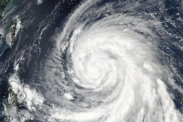
Megi, is a new typhoon which has been intensifying rapidly after forming over the weekend, it is now moving west-northwest towards the central east coast of Taiwan.
Water temperatures and available moisture are both high enough in the region to favor further development.
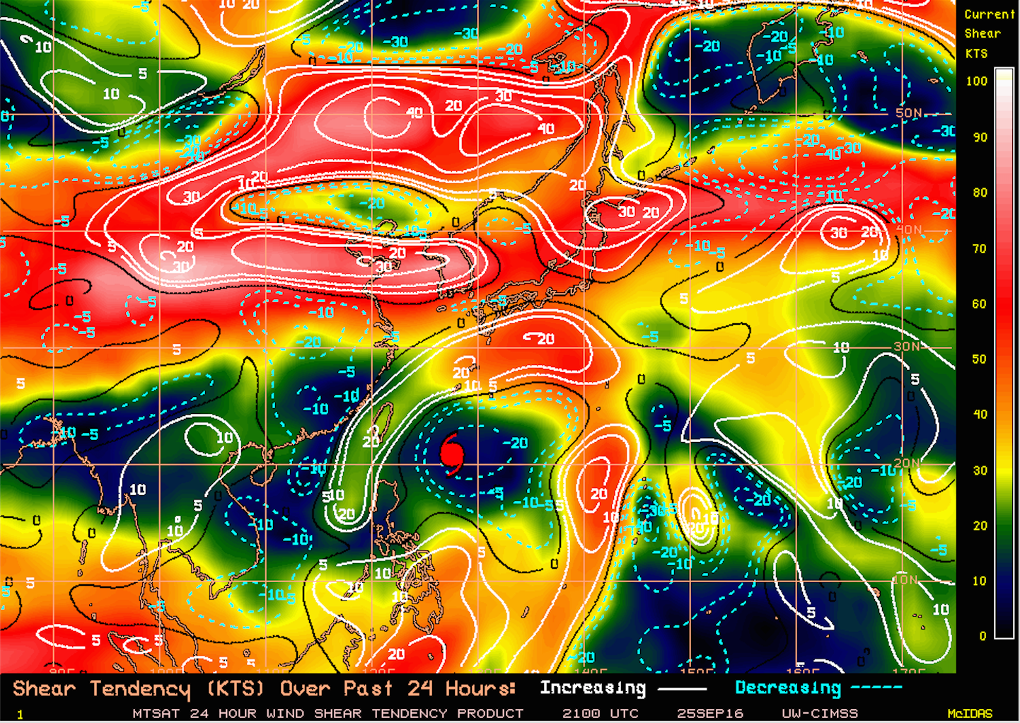
Wind shear conditions have also been favorable for the storm to gain momentum, and it looks like they will continue to be that way for the next 24 hours. However, before reaching Taiwan in a couple of days, higher wind shear conditions could keep Megi from growing stronger into a super typhoon.
![]() STORM TOOL KIT: Be prepared for severe weather with The Weather Network's online essentials: ALERTS | LIVE RADAR | UPLOAD PHOTOS/VIDEOS | LATEST NEWS | FOLLOW ON TWITTER | HIGHWAY FORECAST | AIRPORT FORECAST
STORM TOOL KIT: Be prepared for severe weather with The Weather Network's online essentials: ALERTS | LIVE RADAR | UPLOAD PHOTOS/VIDEOS | LATEST NEWS | FOLLOW ON TWITTER | HIGHWAY FORECAST | AIRPORT FORECAST
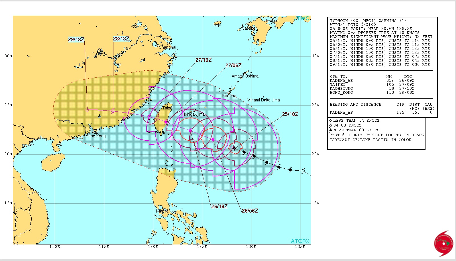
According to the latest JTWC (Joint Typhoon Weather Center) forecast, the storm should strengthen from a Category 2 to a Category 3 typhoon by early Tuesday and remain as such when impacting the east coast of Taiwan later on Tuesday.
If model predictions are on track, landfall winds could be close to 201 km/h, accompanied by high surf and very heavy rains capable of producing frequent landslides along the hilly country of Taitung and Hualien counties.
Luckily, the east coast of Taiwan is not as heavily populated as the west coast, although over half a million people live in these two counties.
![]() NOW ON YOUTUBE: Subscribe to The Weather Network's YouTube channel for access to the best weather-related videos in Canada VIEW THE CHANNEL | VIEWER VIDEOS | POPULAR NOW | SUBSCRIBE
NOW ON YOUTUBE: Subscribe to The Weather Network's YouTube channel for access to the best weather-related videos in Canada VIEW THE CHANNEL | VIEWER VIDEOS | POPULAR NOW | SUBSCRIBE
On July 8th Super typhoon Nepartak made landfall along the the southern end of Taitung causing major damage to buildings, and dumping a tremendous amount of rain across many sections of the island which forced thousands to evacuate their homes. Winds then were close to 150 mph although Taiwan's rugged terrain, a continuous mountain range stretching north-south along the center of the island, helped weaken the storm rapidly.
Below: Precipitable Water in West Pacific
As typhoon Megi crosses central Taiwan late Tuesday into Wednesday, it should experience a similar downgrading process as that lived by Nepartak back in July.
By Thursday, the storm should be crossing the waters of the Strait of Taiwan as a much weaker Tropical Storm, before reaching southeast China somewhere along the coast of Fujian, the same province that was recently impacted by typhoon Meranti.


