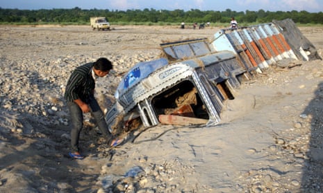
This week a landslide in Kashmir killed more than 400 people and left hundreds of thousands stranded by flooding. As the world adjusts to a changing climate, scientists expect to see rising numbers of landslides like this.
Climate change is accelerated in mountain regions, where temperatures and rainfall patterns are already changing. It’s hard to predict exactly how rainfall will be affected in any one place, but the lashings of rain that affect monsoon regions are forecast to get stronger. Rainwater clogs up the tiny air gaps in soil, bringing already unstable land closer to the brink of collapse. The loss of snow and ice which binds together loose debris on hill slopes is disappearing, further increasing the chance of dangerous landslides.
British universities produce a large amount of the world’s leading research into landslide hazards, but much of it remains locked behind publishers’ pay walls. Landslides rarely come as a surprise to the geological community, and yet they often aren’t on the agenda of NGOs working on the ground.
If valuable research is shared effectively, it can help reduce the risk of disasters. In 2010 a landslide in India-controlled Kashmir, fed by strong monsoon rains, wiped out a Tibetan refugee camp on the flood plain below. Hundreds were killed. If development practitioners had consulted with geologists, they never would have located the refugee camp on a flood plain.
Some scientists are now working to get their research into the hands of people that need it, but communication channels between academics and NGOs are not yet well established.
A conference on the sustainable development of the Himalayas, held in the small town of Leh in June this year, invited internationally acclaimed scientists from the UK, USA and central Asia to speak alongside politicians, development practitioners and local experts. But events like these, sadly, are rare. Scientific research needs to be publicly available and disseminated in easily understandable terms, and development practitioners need to integrate research into their practice.
Both groups can benefit further from consultation with communities in the affected regions. Over a tenth of the world’s population live in mountain regions, where they are highly exposed to dangerous events such as floods and landslides. Many of these people live below the poverty line, often without access to radios or telephones, making them particularly vulnerable. We need scientists, local communities and NGOs to work closely together if we want to reduce the risk of future disasters.
One place where such cooperation is already in action is in the Himalayan kingdom of Baltistan, where scientists have been consulting with the local elderly. Tracking past disasters is important for understanding how they may cause problems in the future. This can be assessed through traditional fieldwork techniques as well as high-tech observations from satellites, but historical records are invaluable for understanding risk at a local level. In Baltistan illiteracy rates are high and the ongoing Kashmir war has prevented much outside access and documentation, so the memories and stories of the elderly have become important historical records. These records are invaluable for understanding risk at a local level.
One example of where this has proven to be useful is the case of Ruzi Mohammed who we interviewed. Ruzi said he suspects that he is around 110 years old. He is illiterate and has only left his village once, when he travelled for three days by foot to see a doctor. Scientists spoke to Ruzi about his memory of a flood when he was four years old (around 1907):
“My family heard the water coming and we climbed up the hillside. The water came around the corner very quickly and we watched our village being washed away. Only the mosque survived.”
From Ruzi’s description of the flood, geologists were able to guess that it was caused by a dam burst following blockage of the Indus River (a secondary hazard that can result from landslides).
NGOs and local authorities can also benefit from community consultation. In 2005 a rainfall-triggered landslide destroyed the village of Panabaj, Guatemala, in 2005. The relocation site chosen by authorities stood on an alluvial fan, where there was a high risk of further landslides. In this case the affected community, fearing a second disaster, lobbied hard for an alternate site. Local communities have an intimate knowledge of the land that is often overlooked outside experts.
Geologists, sadly, expect to hear more stories of disasters coming out of the world’s mountain regions in the coming decades. This additional effect of climate change presents a major challenge to those working in disaster relief, but one that we are better prepared to fight if scientists and NGOs work closely together and integrate the wisdom of local communities.
Rosalie Tostevin is Himalayas programme officer at Geology for Global Development. Follow @Rosalietostevin on Twitter.
Read more stories like this:
Why gender disaster data matters: ‘In some villages, all the dead were women’
The untold story of the Pacific Islands
Flooding in Nepal: will the economy survive the deluge?
Advertisment feature: Cities can lead on climate change to build a resilient future
Join our community of development professionals and humanitarians. Follow @GuardianGDP on Twitter.

Comments (…)
Sign in or create your Guardian account to join the discussion