by Antonio José Paz Cardona / Mongabay
- The erosion has progressed at an accelerated rate and has reached other rivers, threatening a national highway and Indigenous communities.
- Studies commissioned by the Ecuadoran government call for emergency infrastructure to mitigate the erosion, which could reach the catchment dam of the Coca Codo Sinclair hydroelectric plant, with disastrous consequences.
- The Kichwa Indigenous communities affected by the oil spill four months ago say they are still waiting for justice from the government and the pipeline operators.
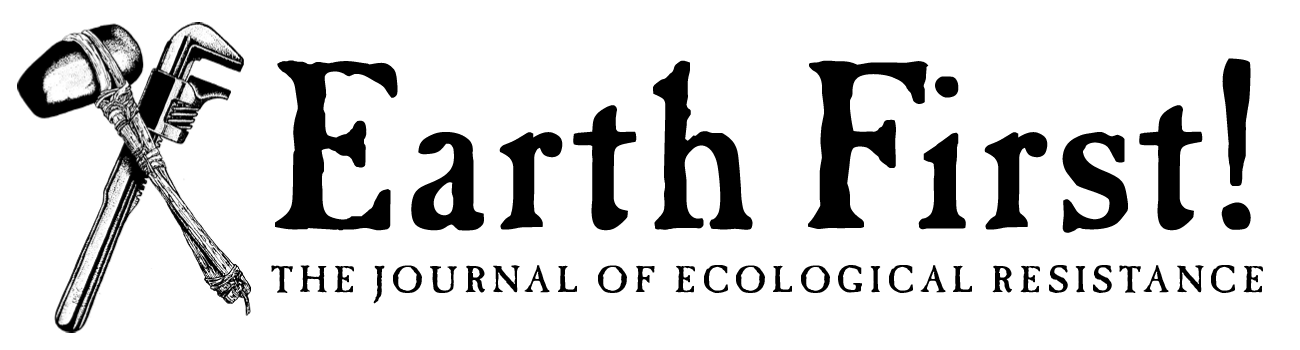
The collapse of the San Rafael waterfall on Feb. 2 and the accelerated regressive erosion that began to occur on the riverbed and edges of the Coca River have turned into a huge problem for the Ecuadoran government.
The San Rafael waterfall, the highest in Ecuador, is located in Cayambe Coca National Park, between the provinces of Napo and Sucumbíos. When the 150-meter (500-foot) falls disappeared, experts consulted by Mongabay warned of the enormous risk this phenomenon posed, especially to the oil pipelines that pass through the area, a national highway, a nearby human settlement, and the catchment dam of the Coca Codo Sinclair hydroelectric plant.
On April 7 and 8, three pipelines ruptured due to landslides along the river and spilled nearly 57,000 liters (15,000 gallons) of oil into the river, affecting downstream Indigenous Kichwa villages and communities. The communities have complained of a lack of “effective and timely reparation” to address the threat. More than two months ago they sued the government and the oil companies.
Only after the oil spill occurred did the government, led by the Ministry of Energy and Non-Renewable Resources, begin to rigorously monitor the erosion. In a press conference on July 9, Minister René Ortiz acknowledged that they “started monitoring more frequently after the fortuitous incident of April 7.”
The Ecuadoran government and several geologists insist the fast-creeping collapse of the riverbed is a natural phenomenon, despite the fact that other experts consulted by Mongabay say the erosion process could have been accelerated due to the sediment retention at the Coca Codo Sinclair (CCS) dam. Either way, the erosion is progressing rapidly and is putting at risk the entire upstream area of the now-disappeared San Rafael waterfall.
Four kilometers of erosion in five months
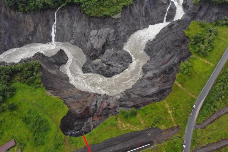
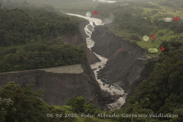
Up to July 6, the regressive erosion of the Coca River had advanced 3.8 kilometers (2.4 miles). For several weeks the tributary encountered rocky material that prevented the erosion from progressing. The containment, however, was temporary, and the process is now continuing with more force. The phenomenon has been much faster than experts like Alfredo Carrasco and Emilio Cobo imagined.
One of Cobo and Carrasco’s main concern is that since June, erosion has already been seen not only progressing along the Coca River but also along one of its tributaries, the Montana River. This has put at risk a bridge on the Baeza-Lago Agrio road. The road had to be closed as a precaution for more than a month.

Cobo, coordinator of the IUCN’s South America water program, consulted again for this article, said the erosive front in the main channel of the Coca River stopped for a month and a half due to rocky debris from the Reventador volcano. But those rocks have been gradually giving way.
“With the rain of the last three weeks, the process has returned to a rapid rate of erosion. There were times when it advanced more than 100 meters [330 feet] per day, which is alarming,” Cobo said. Carrasco, a geologist, natural resources management consultant and former secretary of natural capital at the Ministry of Environment (MAE), added that “between July 3 and 6 the erosion progressed 540 meters,” or nearly 1,800 feet.
Carrasco has visited the area on several occasions and has been closely monitoring the erosion. He said he reached the Coca River on July 1 and found that the regressive erosion was no longer at the confluence of the Montana and Coca rivers, but 450 meters (nearly 1,480 feet) upstream. When he left the region, on July 3, the erosion had advanced by another 475 meters (1,560 feet).
“The process was so accelerated that I was surprised. The waterfalls that I had seen in June [that had been forming as the erosion progressed] have already disappeared and erosion of about 35 meters [114 feet] is probably advancing in those places. Erosion could reach the town of Manuel Galindo in the next 15 days if the river’s energy caused by the rains is maintained,” Carrasco said.

He said it’s important to constantly monitor the Coca and Montana rivers and other bodies of water that could be affected by the erosion: the Loco River, Marker River, Piedras Finas gorge, and Malo River.
Several geologists note that at the Malo River, about 5 km (3.1 mi) upstream from where the erosive front is currently located, there may be an area of volcanic lava that could act as a stable anchor point in the long term. However, “if it’s not the case, erosion will continue to progress and that’s worrying,” Cobo said. “I don’t think it will reach the [Coca Codo Sinclair] dam in less than a year, but both the pipelines and the highway will be exposed. The Montana River is already dealing with the consequences and it is possible that the Marker River will begin an erosion process in the coming weeks.”
The action plan to tackle regressive erosion
According to official information from the Ministry of Energy and Non-Renewable Resources, by April 24 the erosion had already advanced 1.7 km (1.1 mi). Despite this, a day before, Coca Codo Sinclair issued a statement where the vice minister of electricity and renewable energies, Luis Vintimilla, said they had “almost 100% confidence that the hydroelectric power station was not at imminent risk, not even in the medium or long-term.”
Months later, however, the reality is different, and the energy minister, René Ortiz, acknowledged on July 9 that the CCS catchment dam could be in danger. “We are taking preventive measures before this infrastructure [CCS] is at risk,” Ortiz said. Gonzalo Uquillas, the general manager of the Electricity Corporation of Ecuador (Celec), said that “the risk of CCS being affected still exists and that is why it’s essential that we take precautions. The fundamental variable is the speed of the regressive erosion process, which will tell us how much time we have to intervene.”
Despite the warnings that experts like Cobo and Carrasco have given since February about the disappearance of the San Rafael waterfall and the erosion of the Coca River, only on May 11 did the Ecuadoran government sign an official declaration of emergency in this important area of Cayambe Coca National Park. Ten days later, on May 21, the government hired three consultants: one to conduct hydrogeological studies and to plan the new infrastructure; another for topographic studies; and the third for geological studies.
On July 9, the energy ministry announced the outcome of the consultants’ studies and declared that the construction of new infrastructure would begin in the middle of the month. “As of July 15, the construction of a ramp that will be set in the river will begin. Also, the channel will be expanded to alleviate the force of the flow,” Ortiz said.
That would be only the first phase of the action plan. At the same time, a second phase will begin, consisting of several stages: commissioning a series of complementary studies, which must be done no later than Sept. 15; designing the new infrastructure by Aug. 1, which must be completed by Oct. 1; and, finally, constructing the said infrastructure in October, which could take between seven and eight months to complete.

It’s estimated the strategy to deal with the regressive erosion of the Coca River will cost $20 million. Uquillas, the Celec manager, said this figure will change and costs will be even higher.
Uquillas also revealed some of the results and suggestions made by the consultants. One of the key findings is that, so far, between 40 million and 60 million cubic meters (1.4 billion to 2.1 billion cubic feet) of sediment have been detached and that “the accumulation of sediment downstream could represent flood risks for nearby communities, the Coca Codo Sinclair discharge tunnel and eventually the powerhouse,” Uquillas said.
The Ecuadoran government has many challenges ahead, among them, determining the speed of the erosive process and the search for rock formations in the river that can help contain the phenomenon. “That is not easy and we must conduct hundreds of laboratory tests. In many areas these formations are located up to 200 meters [660 feet] below the Coca riverbed,” Uquillas said.
The matter is so complex that Kawsus, the company hired to carry out the topographic survey upstream of the former San Rafael waterfall, expressed the need to extend the study area 50 km (30 mi) downstream, almost at the confluence of the Coca and Napo rivers, with a width of 600 meters (2,000 feet). Uquillas said it’s essential to track and monitor sediment levels in real time.

The effects of the oil spill
Mongabay previously reported how the oil spill that occurred between April 7 and 8 had affected about 27,000 Kichwa Indigenous people living downstream from the collapsed San Rafael waterfall. The Indigenous people, and other inhabitants of the area, have complained of health problems as a consequence of the spill, as well as negative impacts on fishing and access to clean water for consumption. On April 29, they filed a lawsuit seeking precautionary measures, but so far nothing has been done about it.
On July 9, representatives of the Native Union of the Ecuadoran Amazon Communities Federation (FCUNAE), from the Confederation of Indigenous Nationalities of the Ecuadoran Amazon (CONFENIAE), marched on the Judicial Council of the city of Orellana to report the serious situation that their communes face due to “the worst oil spill of the last 15 years in the Ecuadoran Amazon.
In a document, the Kichwa indigenous people requested the reinstatement of the protective action hearing with precautionary measures, which had been suspended for more than a month, and stressed the need to respect due process and act quickly.
Indigenous leader Carlos Jipa, along with religious and human rights organizations, is seeking comprehensive reparation for the damage caused. However, “almost three months have elapsed from the filing of the action and no resolution has been given,” Jipa said.

Miguel Grefa, an elder from the Huataraco community, said this would not be the first march. “Today, the leaders of the communities had to travel for several hours in a canoe, leaving our families to demand attention and justice from the government and the companies Petroecuador and OCP,” he said, referring to the operators of the pipelines. “But if they don’t do anything, we will return with our whole communities. We do not have water, the bottles [distributed by the oil companies] are not enough, we have to use the river water even if it is contaminated.”
Roberto Grijalva, operations manager at OCP, said progress has been made, with more than 60% of the environmental remediation already completed. “This implies that there is still work to be done and for this, we have more than 1,200 people working to achieve comprehensive reparation. OCP Ecuador is doing it committedly, without sparing resources and will continue to do so until the end,” he said.
Grijalva added the company has delivered more than 1.3 million liters (343,000 gallons) of water and more than 18,000 food kits, and has served more than 112 communities and more than 5,000 patients through medical brigades visiting the area. “All these actions are being carried out in conjunction with EP Petroecuador,” he said.
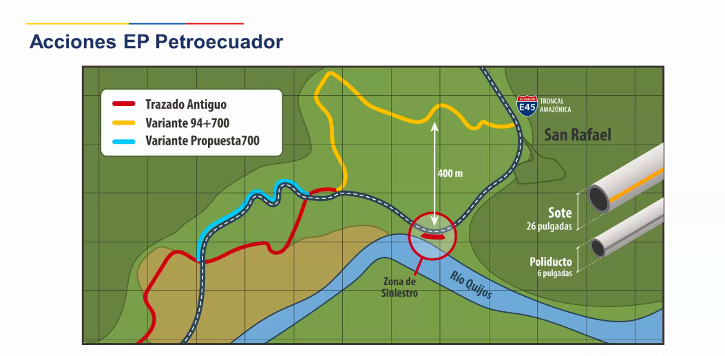
The vice minister of hydrocarbons, María Elisa Soledispa, said Petroecuador has built two bypass lines for each of the two pipelines that collapsed in April — the Trans-Ecuadoran Oil Pipeline System (SOTE) and the Shushufindi-Quito Polyduct — which has allowed it to move between 200 and 400 meters (660 and 1,310 feet) from the riverbed of the Coca River, especially at the confluences of the Marker and Montana rivers. The first bypass for SOTE was built in April, running 1.75 km (1.09 mi); construction on the second began in May and will run 1.1 km (0.7 mi). The first bypass for the polyduct, meanwhile, runs 1.32 km (0.82 mi) and the second 1.8 km (1.1 mi). Soledispa said a third bypass is planned for SOTE that will have an extension of 0.79 km (0.49 mi).
OCP’s Grijalva told Mongabay that the company built a 1.7-km (1.06-mi) bypass in the eroded area to reestablish crude exports.
Despite all this, Verónica Grefa, the president of the Toyuca community, said there “are hundreds of communities that not only see our right to a healthy environment, health, food and a dignified life violated, but also our right to defense and access to justice, among others.
“And although we are in this vulnerable situation, the institutions do not reach the communities to offer us adequate and continuous medical care,” she said. “This is why we have to mobilize.”