A number of photographers have chosen to use Google Maps as a camera. These photographers explore the map and take photos either by capturing a screenshot or photographing the image on their computer monitor with a camera. Exploring Google Maps with a camera allows you to travel to places you couldn’t normally travel or wouldn’t want to be in person. Using Google Maps as a camera also gives you the thrill of discovery and exploration while traversing a virtual representation of our world.
The images created with Google as the camera are pixelated and soft in focus with muted colors. However, the images can be saved and made into prints for presentations in galleries or books. The low fidelity nature of the photographs doesn’t affect their ability to document our world through a facsile of our world.
Living in Map
Google Maps reminds me of a short story written by Jorge Luis Borges called, ‘On Rigor in Science.’ The tale concerns a king who wanted to create the most accurate map of his territory. To accomplish this he commissioned a map where one square mile of territory was represented by one square mile of map. While a map with this magnitude of detail is unfeasable, Google has accumulated map data in concert with aerial photos and street view photos that aims for the fictional king’s level of detail.
This level of detail allows you to explore a virtual space that represents our physical space. This virtual space is immense, consisting of more than 5 petrobytes of data. You may not be able to live in this map but it offers you a nearly endless world to search.
Using Google Maps as a camera allows you to find images that are mysterious and difficult to explain. Often it is possible to find events that seem to be unfolding in this virtual space. These events are artifacts of our human existence in our physical space.


Three Types of Imagery Available in Google Maps
Aerial Images
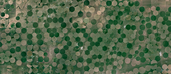

Google maps contains aerial photos that cover the entire planet's surface. These images are created by a system of satellites that circle the planet and are intended to provide information about locations based on what you can see from above. The aerial images can be used to show an area in a way that you can't without the use of an airplane or drone, although the satellite images are taken from an even higher elevation than either of those. Aerial photos are a great place to look if you want to find photographs that have a different perspective and that can leave a viewer feeling as if they are looking at an abstracted image.
Street View Images


Street view images are created by a car with a camera attached to the top. The camera takes 360 degree spherical images. The car drives down roads and creates a sequence of images that are intended to accurately describe the street. Urban places in the United States are the best and most frequently covered, however Street View images can be found from over 39 countries. Unfortunately, the more rural and remote a road is, the less likely it will be covered in street view. Google has created a tricycle system and a backpack mounted system in addition to others to expand street view into places where cars can’t travel.
Historical Images


The aspect of time can be explored when using Google Maps as a camera. Google’s cars create updated imagery for Street View. The newest imagery is always presented first but the historical images can be accessed by pressing the Clock icon on the menu in the top left. Street View was launched in 2007, so a relatively recent project, but imagine if Street View is around for another hundred years: how well these will work as a resource for historical imagery. Street View could become an extremely important tool that will help us visualize the past and see how a place has changed over time.
Found Objects, Found Images, and Photographic Evidence
Found objects have long been considered art. Artists such as Marcel Duchamp pioneered the found object as art. His most famous example is a urinal turned on its side and signed with the name R. Mutt. Duchamp gave this piece the title The Fountain. Duchamp intended to create art by changing the context in which something is viewed. Initially, his work was rejected from exhibitions but it slowly found acceptance as art.
The images created when using Google Maps as a camera are much like found objects. While found objects have been accepted as art for quite some time, the found image is steadily gaining its own acceptance. When searching through Google maps to find an image, you are selecting a particular image that you will present outside of the context of the Google Map program. This re-presentation significantly changes the context of the image.
Can the found image be considered a photograph? Yes, because it is much like selecting an image from the real world that you want to photograph with a camera. In this circumstance, however, you are searching through a virtual world, a recreation of our world, to find this image.
Photographers using Street View as a camera have even been in contention for prominent awards and shown in prestigious galleries. Michael Wolf received an honorable mention in the 2011 World Press Photo competition and Mishka Henner was added to the shortlist for the 2013 Deutsche Börse Photography Prize. Doug Rickard’s series, ‘A New American Picture,’ was shown at MOMA in New York. These examples highlight the acceptance of photos Google Maps as a camera in the media and in art. Now, you'll find many blogs and websites devoted to discoveries from Google Maps.
Explore the Map
Google’s effort to catalog our world with images creates a vast virtual space to explore. From this catalog of images one can find an almost endless variety of photographs. Google map and Street View are a new, giant, virtual world that you can explore photographically.