Indiana Joneses run hi-tech race against Islamic State
- Published

Some of the Middle East's most highly prized archaeological treasures are under threat from the extremist militants of Islamic State (IS).
So archaeologists are desperately trying to record as much of these sites as they can.
And, in contrast to Indiana Jones and its low-tech bullwhip, they're using the latest technology to do it.
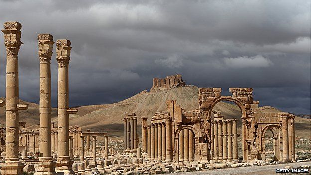
But it may already be too late for the ancient city of Palmyra in Syria. This once-rich oasis straddling age-old caravan routes, featuring colonnaded porticos and the sleek sandstone Tower of Elahbel, fell to IS on 21 May 2015.
The city is now strewn with landmines.
And according to reports, the militants promptly destroyed the 1,900-year-old Lion of Al-lat statue.
Digital ghosts
No wonder archaeologist Roger Michel is in a hurry to preserve - if only in digital form - the relics lying in the militants' onward path.
Mr Michel's team from the Institute of Digital Archaeology - a joint venture between Harvard University and the Classics Conclave - is hoping to flood the area with 3D cameras and enlist local partners to photograph as many items of historical interest as they can.
"If we can get 5,000-to-10,000 [3D cameras] in the field in the next three or six months," he says, "then, if we can't protect these things at the ground, we can at least preserve a highly detailed record of what's there."
He is relying on a patchwork of local museums, non-governmental organisations and volunteers to carry out the digital archiving.
But taking and uploading complex photos in hot, desert conditions where internet access is patchy is challenging.
The cameras need to be robust, have a long battery life and be capable of uploading large files.
"We're working a lot on the battery, since there will be limited access to electricity," Mr Michel says.
They have partnered with New York University's Institute for the Study of the Ancient World to store the 3D images, and with Massachusetts Institute of Technology Three Dimensional Printing Laboratory to print them.
View from the air
The threat from IS has added a new urgency to archaeologists' attempts to record mankind's cultural history.
The Universities of Oxford and Leicester have been using satellite imagery and aerial photography as part of a project called Endangered Archaeology in the Middle East and North Africa.
The £1.2m project will create an open-access database, registering information about each site and its condition, all in easily accessible Geographic Information System [GIS] format.
Remote monitoring is particularly useful in war-ravaged countries like Syria, Iraq, and Libya where on-the-ground surveys are dangerous.
Oxford's Professor David Kennedy, who works with the project, has spent his career refining the techniques used in aerial archaeology.
He has flown in helicopters over Jordan - the only Middle Eastern state to grant him permission - annually for the past 19 years, photographing vast Roman roads and kite-shaped prehistoric animal traps.
While aerial archaeology has been around since French Jesuit missionary and aviator Pere Antoine Poidebard pioneered it in the 1920s and 1930s, modern methods use high-quality cameras, sensors and other sources, such as Google Earth and Bing.
"The resolution is very high, and we can start looking at the neighbouring countries that won't let us fly," says Prof Kennedy.
Only three of the prehistoric kite-shape animal traps had been found in Saudi Arabia before the arrival of Google Earth, he says. Now he has discovered 900 in one relatively small area of the centre-west.
There are now 91,000 images and maps - most of them available on flickr.com - stored by Prof Kennedy's Aerial Photographic Archive for Archaeology in the Middle East.
Virtual diggers
Beyond 3D scanners and Google Earth, a new suite of technologies are bringing archaeology into the 21st Century.
Lidar, a form of radar that use light from a laser instead of radio waves, is helping researchers, like Dr Damian Evans at the Ecole Francaise d'Extreme-Orient, to peer at previously unknown precincts that once surrounded the Cambodian temples at Angkor Wat.
"Using the technology, we can map out the contours of the neighbourhoods, canals, streets, and the fabric of the urban context of the temples," he says.
And ground-penetrating radar is revealing archaeological secrets.
For example, Stonehenge, we now know, was a full circle fitting into a larger complex, including a buried henge two miles away.
And a buried timber building reveals links with the continental property market of 6,000 years ago, too.
Professor Vincent Gaffney, national project leader of the Stonehenge Hidden Landscape Project, says most of the technology now being used at Stonehenge is not new.
"What is different is the speed and the resolution at which we can collect this data," he says.
He points to the importance of the global positioning system (GPS) in particular.
"Everything is being 3D-ed in," he says, recording the precise positions of every object, on landscape-scanning scales in real time.
The future of our past
Dealing with the vast swathes of digital data the new archaeology is yielding, and making it accessible for others, is challenging, says Victoria Yorke-Edwards, editor of the Journal of Open Archaeology Data.
And as archaeologists start inventing new ways to use the tech, finding peers with the technical expertise to review the research it produces is sometimes difficult, she says.
But there is no doubt that the technology is challenging many of the assumptions once taken for granted in the field of archaeology and giving adventurous would-be Indiana Joneses the chance to unearth new treasures.
"It brings out the Indy Jones-loving side of everybody," says Miss Yorke-Edwards.
Although, as she points out: "If you watch the films very carefully, really, he didn't record anything."