Australia's peak science and research organisation today released a homegrown software tool to help emergency services predict the severity and spread of destructive bushfires.
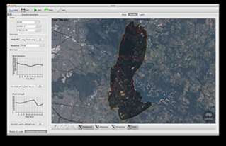
The CSIRO's Spark tool gathers geospatial data on topography, vegetation, humidity and wind patterns from Landsat satellites, and combines it with data provided by fire authorities to give an accurate prediction of fire behaviour.
The organisation expects Spark will not only help emergency services save lives, but also reduce the financial burden of bushfires.
Spark should also allow emergency services to better manage infrastructure planning, fire fighting resource allocation and deployment, evacuation routes, fuel reduction burning, and reconstruction of historical fires, the organisation said.
CSIRO computational modelling researcher Dr Mahesh Prakesh said the tool can relay data on fire behaviour within 15 seconds.
“Spark has the potential to be used operationally for real-time fire spread modelling of bushfires,” Prakesh said.
“The next step is to work with rural fire authorities and land management agencies to incorporate Spark into bushfire planning and management processes.”
The tool is based on Workspace, CSIRO’s in-house developed workflow software. The platform allows the CSIRO to integrate Spark into pre-existing emergency response systems.
Prakesh said Spark was still in the early stages of being rolled out, but the CSIRO was in talks with a number of Australian fire and evacuation authorities.
A demo of Spark is available to download now from the CSIRO website, with updates expected every quarter. Users can also provide feedback on Spark improvements.